Geology and Natural Heritage of the Long Valley Caldera
Geological Processes Shaping the Mono Basin
Julie Xu
Abstract
Located in the Basin and Range province, Mono Basin is a 1 to 3 million year old, structural depression bordered by a fault escarpment on the eastern margin of Sierra Nevada (Mono, 2015). When the Farallon plate finished subducting under the North American plate 20 m.y.a, the Pacific plate started to slide northwest against the North American plate (Tierney, 2000). This tectonic environment has given rise to active faulting, earthquakes, volcanic activity, and crustal extension in the Mono Basin. Warped, flexure-like highlands around Mono Basin suggest that crustal stretching associated with the Basin and Range Province formed the Mono Basin. Different morphology of moraines and weathering of other glacial till deposits provide evidence of multiple glacial periods. Additionally, a wide distribution of tertiary and quaternary volcanic deposits and landforms, such as the Mono Craters, signify the region’s rich, sporadic volcanic history. Lake sediments on the Mono Basin margins, shorelines marks characterized by abrupt changes in plant species density and composition, and dendrochronology data suggest significant past lake level and climate fluctuations. Continued crustal extension but minimal quaternary faulting along the front opposite to the Mono Craters serves as evidence of an intrusive dike system underlying the Mono chain.
Introduction
Mono Basin offers a unique ecological, volcanically active environment in the Basin and Range province, which is characterized by high topographic relief and numerous faults. This terminal basin is bordered by Bodie Hills to the north, Cowtrack Mountain to the west, Long Valley Caldera to the south, and a fault escarpment by Sierra Nevada to the west. Sagebrush is the dominant vegetation covering Mono Basin. Gravity, landslides, and erosional agents such as ice, water, and wind have carried material down from the mountain and filled the basin with sediment (Tierney, 2000). At the deepest part of the basin lies Mono Lake, one of the United States’ oldest lakes, covering over 60 square miles. Mono Basin resides in Sierra Nevada Mountains’ rain shadow, and most inflow comes from Sierra snowmelt. Streams flow into Mono lake, but there is an absence of drainage pathways, accounting for the lake’s high alkalinity (pH = 10) and salinity twice the ocean (Mono, 2015). Despite this chemically extreme environment, the lake hosts a rich ecosystem consisting of algae, extremophile microscopic organisms, alkali flies (Ephydra hians), brine shrimp (Artemia monica), and migrating birds, such as the California Gulls (Larus californica), Wilson’s Phalaropes (Phalaropus tricolor), and snowy plover (Charadrius nivosus) (California, 2014). Mono Lake is well known for Los Angeles Department of Water and Power (LADWP) controversial water diversions of creeks feeding into the lake. Water is an especially valuable resource for L.A. due to the current drought and highly populated city.
Past Tectonic Processes
Before the Basin and Range province was created, the Farallon plate subducted under the North American plate, thickening and heating the crust. After the Farallon plate completely subducted, the once convergent plate boundary changed to a transform plate boundary, in which the Pacific plate on the west continues to slide past the North American plate on the east. This transform tectonic movement gave rise to the 950 km long San Andreas fault. This also created a slab gap, an area with no Farallon plate between the mantle and North American continent. Contact from heat generated by the mantle caused the overhead continent to become less rigid, leading to crustal extension. The Sierra granite bedrock in Mono Basin is depressed 3,353 m below the Sierra crest, suggesting the fault escarpment on its western border is from crustal warping (Hill, 2006). 3 to 4 million years ago, crustal stretching uplifted the Sierra Nevada mountains while down dropping the Mono Basin block. Additionally, Mono Basin is one of several vertically down-dropped basins (Graben) amongst uplifted north-south oriented ranges (Horst) in the Basin and Range Province, further demonstrating crustal stretching caused by normal faulting and dike intrusions (Christensen et al., 1969).
Current Tectonic Activity
Extensional forces are still active in this pull apart basin (Figure 1). The Pacific plate is currently slipping northwestward past the North American plate, generating earthquakes, and relatively recent volcanic activity. Recently in the late Quaternary period, the Sierra range front bordering Mono Basin to the west has experienced minimal faulting. Bursik and Sieh (1989) suggest strain relief provided by intrusion of dikes below the central and southern Mono Craters accounts for this lack of faulting. Dikes are tabular magma bodies intruding into surrounding rock. They are created from magma rising through a fracture or crack in nearby rocks and then cooling into a solid (Dike, 2008) Previously, dike injections induced extension rates resembling faulting rates; however, over the last 14,000 years, the dikes are measured to be intruding with a greater rate of extension than range front faulting from inflation or increased pressure from magma chamber. Therefore, the current extension, previously due to normal faulting, is currently a result of intrusion of dikes below the Mono Craters. Extension in the west-northwest direction has created a slip gap at the Sierra range front and oblique slip faults (have horizontal and vertical motion) oriented north-northwest (Bursik and Sieh, 1989). Dike injections are involved in the earthquake cycle and will play a major role in future volcanic eruptions and earthquakes at the Mono volcanic chain (Long, 2012).
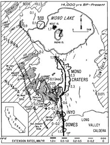
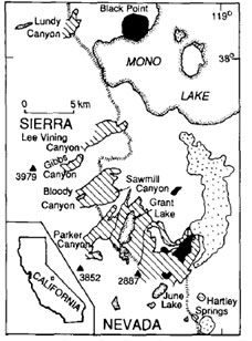
Figure 1: Located in the central, eastern portion of California, the Mono Basin is bordered by the Sierra Mountains, Bodie Hills, Cowtrack Mountain, and Long Valley Caldera to the west, north, east, south respectively. Over the past 14,000 years, the high extension rates of 1.0 + mm/ yr have occurred along the Mono Craters and Mono Lake Islands (Bursik and Sieh, 1989).
Volcanic History
Cenzoic deposits of granite and metamorphic rock make up the deepest portion of the Mono Basin (Figure 2). This granitic basement layer could have been formed from subduction of the Farallon plate. The subducted Farallon plate released water, which altered a portion of the crust’s chemistry from mixing. Magma from mantle rose to melt the above continental crust. Granite magma slowly cooled underground to form granitic plutons underlying Mono Basin, and some rock metamorphosed due to heat from molten rock and high pressure (Hill, 2006).
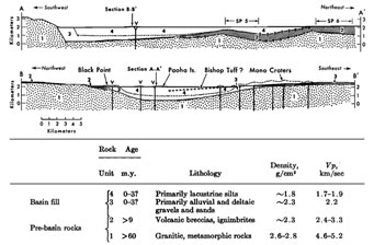
Figure 2: These diagrams represent cross sections of the Mono Basin. Before the Mono Basin was formed, Sierra granitic and metamorphic rocks older than 60 m.y. constitute the basement layer. Older than 9 m.y.a., volcanic breccias and ignimbrites lie on top of the granite at the northeastern edge of the basin, under the Mono Craters, and at Black Point and northwestward. After crustal extension formed the Mono Basin, deltaic and alluvial sediments and lacustrine silts filled the deepest parts of the basin. Bishop Tuff is intermingled within the lacustrine silts on the bottom cross section (Christensen et al., 1969).
9 to 25 m.y. volcanic rocks overlying granite rock were volcanic breccia and ignimbrites distributed over the Mono Basin, indicating multiple, sporadic volcanic events (Figure 2). Landforms indicative of previous volcanic activity surround Mono Lake. Bodie Hills and Cowtrack Mountain are remnants of a volcanic period before the formation of Mono Lake, and Mono-Inyo chain represent more recent eruptions by geologic standards. Eastern crest of Mono Basin has a dip slip fault buried with fill, indicating volcanic activity occurred after the fault formed. Crustal stretching triggered volcanic activity, causing magma to rise under a thin area of crust. Tertiary period rhyolites and andesites cover Mono Basin’s east and north border, especially at Bodie Hills and Mt. Biedeman, suggesting rhyolitc explosions of tephra and ash and andesitic lava flows (Gilbert, 1968). At the eastern part of Mono Basin, 10 m.y. andesite are interposed with more exposed 22 m.y. old rhyolites, implying andesitic flows occurred after explosions of rhyolite. Pliocene era started with latite ignimbrites eruptions from east of the basin. Presence of older than 9 m.y. tuffs, breccia, andesite and rhyolite flows along the northern and eastern border but are absent along the southern and western margin, suggest the andesitic flows and breccia came from north or east Mono Lake vents. Minimal volcanic rocks dated between 7.5 and 4.5 m.y. marked a quiet volcanic period (Christensen et al., 1969).
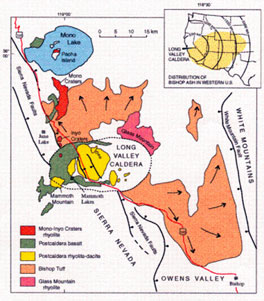
Figure 3: This map illustrates the distribution and composition of material exuded from volcanic eruptions in the Long Valley and Mono Basin area. The Long Valley bishop tuff deposited not only in the Mono Basin area but also radially distributed eastward, as shown by the top right diagram. The Mono-Inyo Craters are composed of rhyolite, and Black Point is composed of mostly post caldera basalt (Long, 2012).
During the past 4 to 1.5 m.y., eruptions occurred from vents at the southern, northern, and eastern basin margins. Crustal stretching and thinning caused the magma from mantle to push up below the ground, resulting in basaltic flows from the east and southern vent of the basin and smaller basalt, latite, rhyolite, andesite flows from the northeastern vents (Christensen et al., 1969). 4.5 to 2.6 m.y. basaltic eruptions from Cowtrack Mountain and Adobe Hills formed newer part of Bodie Hills, Aurora crater, Beauty Peak, Mount Hicks, and Cedar Hill (Tierney, 2000). 0.7 to 1.5 m.y. rhyolite and volcanic domes on Glass Mountains, suggest eruption of a highly viscous magma from high SiO2 content (Figure 3). Bishop tuff in the Mono Basin matching that from the 760,000 years ago Long Valley ash falls demonstrates how vast the eruption was (Huber and Rinehart, 1967). Lake sediments found under a layer of ash from the Long Valley eruption at Paoha Island prove presence of a lake prior to the Long Valley eruption (Figure 2) (Scholl et al., 1967). Latite, rhyolite, and andesite located at Mammoth Mountain and Long Valley provide evidence of continued volcanic activity occurring less than 700,000 years ago.
Formation of Mono Craters and Islands
Mono-Inyo chain, Black Point, and Mono Lake Island formed less than 35,000 y.a. Mono Craters, located south of Mono Lake, makes up North America’s youngest mountain range. These craters are part of the 45-km long north-south trending Mono-Inyo chain, extending from Mammoth Mountain to Mono Lake. Rhyolitic composition of the craters, indicated 500-600 years ago, extrusions of rhyolite created the Mono-Inyo craters (Figure 3). Faults and fissures along the volcanic vents of the Mono-Inyo chain have an N to NNE orientation (Christensen et al., 1969). Rhyolite domes, craters, and flows (coulees) make up the Mono-Inyo craters. Rhyolitic domes indicate eruption of high silica and low gas content magma, and craters were formed from high silica and gas content magma. The older domes (40,000–3,000 y.a.) are porhyritic, indicating magma melt cooled above the ground, allowing time for small phenocrysts to form. The younger Mono Crater domes (3,000–550 y.a.) are aphyric, suggesting magma rapidly cooling above the surface not allowing enough time for phenocryst formation. Bailey (1933) interpreted this change as a result of the eruption source lowering in depth or magma at an elevated temperature.
Tephra scattered all over the Mono Basin indicates volcanic activity from the Mono Crater eruptions (Sieh and Bursick, 1986). The lava dome Mammoth Mountain was created by rhyodacite and dacite eruptions 110,000 to 57,000 years ago (Lewicki, et al., 2006). Lake sediments at the Black Point fissures and angular fragments of basaltic lapilli denote a underwater volcanic eruption. 13,000 years ago, when Mono Lake water covered a larger area, an underwater volcanic eruption gave rise to the basaltic, tephra cone Black Point (California, 2014). Fissures and cracks produced at Black Point’s peak could be formed by tensional forces from crustal stretching or intrusion of magma that cooled, forming cracks.
The northernmost Mono crater, Panum Crater, is a plug-dome volcano erupting only 650 years ago. Pumice and ash located on the outer ring, suggest explosive pyroclastic fall deposits first occurred to form an outer tephra ring. The inner dome made up of pumaceous obsidian and rhyolite, indicate that later, an effusive rhyolitic eruption formed the dome. Obsidian and rhyolite are both formed from felsic (high silica) magma but have different cooling rates. Absence of visible crystals and a glassy texture in obsidian, indicate cooling quickly above the ground, allowing not enough time for crystals to organize to form. Rhyolite is formed from felsic, magma cooling slower than obsidian above the Earth’s surface, forming small grains. Formation of vesicular, pumice-like obsidian is due to high gas content of magma. Breccia was also formed as a result of different rock fragments being held together by a fine matrix (California, 2014).
The dark colored material covering Negit Island are dacitic and rhyolitic volcanic rocks, suggesting that dacitic and rhyolic lava flows and domes ranging from 2000 to 300 years ago created this cinder cone (Stine, 1990). The light-colored Paoha Island, located south west of Negit is a resurgent-like dome. Lake sediments, similar to the lake bottom, cover Paoha Island, suggesting that rhyolite dome magma chamber pushed up at bottom of lake, causing lake bottom sediments to uplift (Figure 4). The darker portion on Paoha Island is made up of rock from the 300-year-old rhyodacite dome found on the neighboring Negit Island, suggesting this is material from the volcanic flow from Negit. At the lake bottom near Paoha Island, Bailey (1933) found four to five circular depressions, indicating subaqueous craters surrounding the island. Steam vents and hot springs on Paoha Island serve as evidence for hydrothermal activity (California, 2014).
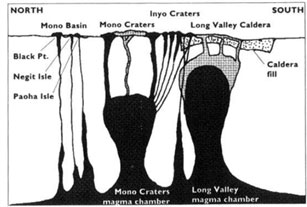
Figure 4: Magma rising from different magma chambers in the Eastern Sierra Nevada region gave rise to volcanic eruptions and formation of the Mono Craters, Black Point, Negit and Paoha Island. Mono Craters and Long Valley have their own separate magma chambers (Tierney, 2000).
Glaciation
Large accumulation of rocks and boulders are present on the southwestern margin of the Mono Basin (Hill, 2006). Huge boulders only can be transported by a medium of high-energy, such as a glacier, indicating the material is glacial till. (Kistler, 1966) also interpreted the material on the Sierran margin south of Lee Vining Creek as Pleistocene eroded till. Bursik and Gillespe (1933) noted moraines along the basin’s western edge (Figure 5), providing evidence of glaciation. U-shaped valleys, glacial erratics, glacial polish and striations in the Sierra Nevada region reaffirm past glaciation. The basin area is flat outside of lake, suggesting glaciation produced a relatively flat, horizontal land (California, 2014).
Bursik (1986) used radiometric dating techniques of clast-sound velocity (CSV) on granitic boulders, morphology of moraines, and weathering on granite to differentiate between moraines in Mono Basin from different glacial periods. CSV is based on the concept that as boulders age, the speed of sound decreases due to increased microcracks. Also morphology and weathering patterns on moraines can distinguish moraines from different glacial periods since erosion and weathering induce changes over time (Bursik, 1986). Difference in the characteristics of the moraines signified multiple glaciation periods. McGee glaciation occurred 1.5 m.y.a,, followed by Sherwin glaciation 1 m.y.a, , Tahoe glaciation 150,000 y. a. to 70,000 y.a., Tioga glaciation 26,000 to 19,000 y. a., and Recess Peak glaciation 15,000 y.a., and then the Little Ice Age from 1250 to 1900 (Hill, 2006).
Glaciation during those periods signify that the winter snowmelt exceeded the summer melts, allowing formation of a glacier. Several glacial retreats and advances, suggest fluctuations in climate occurred during these eras. Hays et al. (1976) matched astronomical cycles with how much heat the Earth receives, demonstrating the orbital geometry of the earth is a major factor of the climate change that formed the Quaternary ice ages. Other agents influencing climate change include eruptions spreading volcanic ash in the atmosphere, which blocks heat from incoming sunlight, or tectonics causing mountain uplift resulting in greater snowfall (Hill, 2006).
Figure 5: The diagonal lines on the western margin of Mono Basin represent late Pleistocene moraines, indicating past glaciation. The dotted area is Quaternary volcanic rock, and the black area represents late Pleistocene basalt and the (Bursik and Gillespe, 1993).
Mono Lake Predecessors
Pleistocene and Holocene fine-grained lake silts make up the basin fill, indicating during those eras, the lake expanded and contracted from climate fluctuations. (Putnam, 1950) identified a trace of a shoreline at an elevation of 2,188 m on the western slope of Mono Lake, which is 143 m higher than the current Mono Lake Visitor Center. Additionally, dated river bed sediments near Adobe Hill and other higher areas prove that 13,000 years ago after the Ice Age, water overflowed and covered an area fives times more expansive than today’s Mono lake. This Mono Lake predecessor is known as Lake Russell (Mono, 2012). Increased water levels result in less saline and alkaline waters that could have potentially serve as a habitat for a complete different set of organisms than that of Mono Lake’s.
Evidence of Lake fluctuations include formation of certain geomorphic delta components on Mill, Lee Vining and Rush creek, which feed into Mono Lake. Mono shore plant density distributions have also served as indicators of past lake fluctuations. Vascular plants cannot grow in Mono Lake due its high salinity and alkalinity. When a lake recedes, the salinity and alkalinity increases since water evaporates, leaving compounds behind that inhibit plant metabolism. Stine (1990) found shoreland below 1959.1 m consisting of mostly barren to sparse vegetation; however, shoreland above the mark was covered with vegetation Additionally, at the 1959.1 contour, there is a abrupt change to lower pH and higher sodium concentrations below the shoreline in comparison to the higher land right above. On the northern, southern, and eastern shores, this difference is especially stark (Zinke et al., 1984). Below the1959.1 m, the vegetation is dominated by rabbitbrush (Chrysothamnus nauseosus var. consimilis), a plant tolerant of high alkaline and saline conditions, but above this level, the dominant species is sagebrush (Artemisia tridentate). Such breaks in the shorelines characterized by sudden change in density and compostion of species is also present at 1969 m and 1981m contour.
Dead vegetation also provides clues to lake fluctuations. On the western shorelands, Jeffrey pines stumps and shrubs are dead from lake inundation. For plant growth, the lake water has to be below the plant’s base (for non extremophiles), so radiocarbon dating of the stump’s wood and growth rings, indicate the time a lake was below elevation a certain elevation. During the Mediaeval periods, Mono Lake had a water level below its historical levels due to a dry climate (Stine,1990). More lake-fluctuation dating needs to be investigated to better understand the forces producing the hydro climate changes.
Input and Outs of Mono Lake
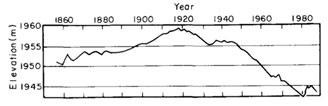
The equilibrium between inflow and outflow determines the Mono lake water level. The three main streams that feed into Mono Lake are Rush Creek, Mill Creek, and Lee Vining Creek. Inputs include precipitation, groundwater and streamflow; however, since Mono Lake is terminal, outflows only include evaporation and manmade water diversions. Fluctuations in the lake can be accountable due to changes in the outflow and inflow. Increased stream diversions by the city of Los Angeles results in sudden decrease in the water level following 1940 (Figure 5).
The evaporation primarily comes from the lake’s surface and is faster during the summer’s higher temperatures (Vorster, 1985). A majority of the water input comes from snowmelt runoff from the Sierra Nevada mountains located at the east of Mono Lake. 80-85% of the rainfall or snowfall occurs from October to May, particularly during the winter months (Graham and Hughes, 2007). Some precipitation from rain, snow, or sleet percolates into the ground, serving as groundwater. Groundwater can percolate up and seep out through springs near Mono Lake. Groundwater only counts as a small portion of the lake inflow, probably due to water loss from groundwater seeping into soil, fissures, and cracks in volcanic and bedrock before flowing to Mono Lake. Some water becomes runoff flowing downwards overland by gravity and eroding and picking up material that it passes. The higher the energy of the water, the larger the rocks it can pick up and transport (Runoff, 2014).
Figure 6: Changing water elevations demonstrate Mono Lake fluctuations in the input and output over the past decades. The rapid decrease in water elevation following 1940 can be attributed to Los Angeles Department of Water and Power (LADWP) water diversions. 1982 represents a low at 1960 m. National Audubon Society and Mono Lake Committee fought through legal means to prevent diversions, causing the State Water Resources Control Board in 1994 to raise the lake level to 6,392 feet by diverting less water (Stine, 1990).
Water Chemistry of Mono Lake
Mono Lake’s waters are extremely saline and alkaline. Since the terminal lake has no outlet expect for water evaporating, the salt and minerals left behind, creating a highly alkaline and saline lake. Sierra streams draw out minerals from surrounding rock such as sodium, potassium, carbonate, calcium and deposit the minerals in this terminal lake.
Calcium carbonate deposits called tufa towers reside along the shores of Mono Lake. Tufa towers tend to be formed at the mouth of springs, suggesting that underground freshwater bring calcium, which combines with the carbonate- rich lake to produce calcium carbonate (limestone) precipitates. An interpretation for this source of calcium could be that running water leeched out the calcium from Sierra metamorphic rock or any surrounding rock. Decrease in the water level has led these tufa towers to be exposed around the lake, especially at the South Tufa towers. These tufa towers range from 13,000 years old at high elevation from Mono Lake’s current shore to 300 years old at the Tufa towers at the southern end, providing evidence to wide fluctuation in the lake level over time. The farthest tufa tower was probably formed during post-Ice age era during the lake’s highest elevation. Sand tufa are also present, indicating calcium rich spring water percolating up through the carbonate rich sand at the bottom of the lake (California, 2014).
Conclusion
The Mono Basin encompasses an active tectonic setting, giving rise to frequent volcanism, earthquakes, and crustal warping. Relatively recent volcanic activity along the Mono islands and Mono-Inyo chain suggest potential future eruptions. 1 mm/yr crustal extension in this region is fed primarily by dike intrusions instead of past range-front faulting (Bursik and Sieh, 1989). Former climate changes have spurred wide fluctuations in historical lake levels and glaciation. Two droughts during the Mediaeval periods caused the lake to recede way below the current Mono Lake’s level, suggesting the current California drought is not anomalous but rather reflective of past drought trends (Stine, 1994). More investigations are needed to analyze past lake and climate fluctuations to better prepare and make predictions for the current California drought.
References
Bailey, R. (1933). Geological Map of Long Valley Caldera, Mono-Inyo Craters Volcanic Chain, and Vicinity, Eastern California. Department of the Interior U.S. Geological Survey, 163-168.
Bursik,. M. and Gillepsie, A. (1993). Late Pleistocene Glaciation of Mono Basin, California. Quaternary Research 39, 24-35.
Bursik, M., and Sieh, K. (1989). Range front faulting and volcanism in the Mono Basin, eastern California. Journal of Geophysical Research 94, 15587-15609.
California Department of Parks and Recreation (2014). Mono Lake Tufa State Natural Reserve [Brochure]. Sacramento, CA: California State Parks.
Christensen, M., Gilbert, C., Lajoie, K., and Al-Rawi, Y. (1969). Geological-geophysical interpretation of Mono Basin, California-Nevada. Journal of Geophysical Research 74(22), 5221-5239.
Dike. (2008). Retrieved June 15, 2015, from http://volcanoes.usgs.gov/images/pglossary/dike.php
Gilbert, C., Christensen, M., Al-Rawi, Y., and Lajoie, K. (1968). Structural and Volcanic History of Mono Basin, California-Nevada. Studies in Volcanology Geological Society of America Memoirs 116, 275-330.
Graham N., Hughes M. (2007). Reconstructing the Mediaeval low stands of Mono Lake, Sierra Nevada, California, USA.
Hays, J., Imbrie, J., and Shackleton, N. (1976). Variations in the Earth's Orbit: Pacemaker of the Ice Ages. Science 194(4270), 1121-1132.
Hill, M. (2006). Geology of the Sierra Nevada (Rev. ed.). Berkeley, California: University of California Press. Holocene 17:197–1210.
Huber, N., and Rinehart, C. (1967). Cenozoic volcanic rocks of the Devils Postpile quadrangle, eastern Sierra Nevada, California,. Washington, D.C: U.S. Govt. Print. Off.
Kistler, R. (1966). Structure and metamorphism in the Mono Craters quadrangle, Sierra Nevada, California. Retrieved June 15, 2015, from http://pubs.er.usgs.gov/publication/b1221E
Lewicki, J., Birkholzer, J., and Tsang, C. (2006). Natural and industrial analogues for leakage of CO2 from storage reservoirs: Identification of features, events, and processes and lessons learned. Environmental Geology Environ Geol. 457-467.
Long Valley Caldera Geology and History. (2012). Retrieved June 15, 2015, from http://volcanoes.usgs.gov/volcanoes/long_valley/long_valley_geo_hist_18.html
Mono Lake. (2012). Retrieved June 16, 2015, from http://volcanoes.usgs.gov/volcanoes/long_valley/long_valley_sub_page_16.html
Mono Lake Quick Facts. (2015). Retrieved June 15, 2015 from http://www.monolake.org/about/stats
Putnam, W.C., (1950). Moraine and shoreline relationships at Mono Lake, California: Geological Society of America Bulletin 61(2), 115-122.
Runoff. (2014). USGS. Retrieved June 7, 2015, from http://water.usgs.gov/edu/runoff.html
Scholl, D., Huene, R., St.-Amand, P., and Ridlon, J. (1967). Age and Origin of Topography Beneath Mono Lake, a Remnant Pleistocene Lake, California. Geological Society of America Bulletin 78(5), 583-600.
Stine, S. (1990) Late Holocene fluctuations of Mono Lake, eastern California. Palaeogeography, Palaeoclimatology, Palaeoecology 78, 333-381.
Stine, S. (1994). Extreme and persistent drought in California and Patagonia during mediaeval time. Nature 369:546–549.
Tierney, T. (2000). Geology of the Mono Basin. Lee Vining, Calif.: Kutsavi Press.
Vorster, P. (1985). A water balance forecast model for Mono Lake, California. Berkeley, Calif.: U.S. Forest Service, Region 5.
Zinke, P.J., Strangenberger, A.G., Post, W.M., Emanuel, W.R., and Olsen, J.S. (1984). Worldwide organic soil carbon and nitrogen data. U.S. Department of Energy.
[Return to Research Projects] [Return to Sierra Home]