Geology and Natural Heritage of the Long Valley Caldera
NATURAL AND POLITICAL HISTORY OF MONO LAKE
Kaitlyn Waling
Abstract
Mono Lake is located in East-Central California near the Nevada state line. It is surrounded by the Sierra Nevadas to the east and White Mountains to the west. Millions of years of tectonic and glacial activity has shaped this area. It originally formed a complex drainage basin connected to multiple southern river valleys, however, over geologic time it has been transformed into a terminal basin. With no water leaving the lake, besides for evaporation, it relies entirely on rain, snow, and five Eastern Sierra tributaries to maintain a healthy, productive ecosystem, for an array of plants and animals. Despite the unique natural history, current social-political issues have arisen due to population growth in large California cities. The ongoing controversy focuses on the supply of freshwater and whether or not streams should be diverted to people of Los Angeles or continue to sustain Mono Lake. As of now an agreement has been reached between environmentalists and the LA Department of Water Resources, to place restrictions on the amount of water that can be diverted via the California aqueducts. The agreement aims to return water levels of Mono Lake to pre-diversion amounts and allow extra flows to supply downstream cities.
Introduction
Mono Lake received its name from the Mono Indian Tribe. In their native language, Yokut, "Mono" refers to "fly people." This specific tribe inhabited the Mono Basin area before the mining goldrush. Fly larva, specifically the Brine (or Alkali) Fly, was a staple in their diet and a major trading commodity [Hill, 2006, p.330]. Mono lake is the second largest lake in California, one of the oldest lakes in North American, and one of the most productive ecosystems in the world [About Mono Lake, 2015]. Due to its rich natural history, ranging from volcanic activity, to glacial episodes, to saline waters, to migratory bird routes, Mono Lake has become "one of the most studied parts of the Sierra" [Hill, 2006, p323]. In the wake of climate change, particularly increased droughts and the need for freshwater diversions, for urban and agricultural development, the area has become a hot spot for political action and environmental advocacy. This summary paper aims to give a brief insight to hydrology, geology, and ecology of Mono Lake and tie it to the water controversy that has been ongoing since 1910.
Natural History
Hydrology
Mono Lake is located in East-Central California near the Nevada state line. It lies close to the middle of the Mono Basin, east of the Sierra Nevada Mountains and west of the White Mountains. It has been present for at least 760,000 years, but possibly closer to one to three million years [About Mono Lake, 2015; Hill, 2006]. The lake is currently 13 miles long by 8 miles wide [Hill, 2006; Mono Basin Geology and Hydrology, 1987]. However, during the Great Ice Age, during the Pleistocene, the lake reached 28 miles long by 18 miles wide, with a depth of 900 feet. With a water level 400 feet higher than it is present day, it was able to flow southward out of the basin. Southbound streams flowed into Owens Valley, Indiana Wells Valley (China Lake), Searles Basin, Panimint Valley, and Death Valley [Hill, 2006, p326]. These "bathtub rings" can still be seen stained on mountains surrounding the lake, marking historical water levels.
At the end of the Pleistocene mono basin became terminal. Freshwater streams continue to flow into the lake from the Sierra Nevada Mountains but there is no longer an outlet for them. The only way for water to leave the lake is through evaporation. The result is a lake with a salt content three times greater than the ocean and 80 times more alkaline [About Mono Lake, 2015; Hill, 2006].
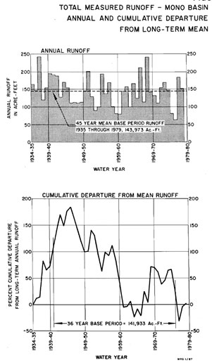
According to Mono Basin Geology and Hydrology [1987], the drainage basin area covered about 750 square miles, half being in the hills and mountains and half being in the valley. Tributaries originate from the eastern slopes of the Sierra Nevada Mountains and include Lee Vining, Parker, Walker, Rush and Mills Creek. The source of water for these streams comes mainly from snowmelt, between April and September. Average yearly snowpack depth at the top of the mountains is about 76 inches. Annual precipitation averages 30 inches atop the Sierra Nevada, 15 inches at the mountain base, and six inches on the eastern side of Mono Lake [About Mono Lake, 2015; Mono Basin Geology and Hydrology, 1987]. Between 1941 and 1976, the average yearly hill/mountain runoff from precipitation sources was 167,000 acre-feet, measured from all five tributary streams [Mono Basin Geology and Hydrology, 1987; Figure 1]. The largest flows came from Rush Creek (60,900 acre-feet or 85 cfs), while the second largest flows came from Lee Vining creek (48,300 acre-feet or 68 cfs) [Mono Basin Geology and Hydrology, 1987].
Figure 1: Mono Basin Geology and Hydrology [1987] graph shows fluctuations in annual amount of runoff from 1941 and 1976.
Geology
When the basin was created, volcanoes, glacial deposits and faults were all operating at the same time [Hill, 2006, p.323]. Because of this, the tectonic basin may have formed by faulting and warping, followed by the extrusion of magma from an underground chamber [About Mono Lake, 2015; Mono Basin Geology and Hydrology, 1987]. Evidence of volcanic tuff overlying glacial till shows that volcanic activity likely occurred before and after the Great Ice Age [Mono Basin Geology and Hydrology, 1987]. Erosion from the Sierra Nevada and White Mountains is responsible for about 4,000 feet of sediment [Mono Basin Geology and Hydrology, 1987], which may also contribute to the compression of the valley and uplift of surrounding hills.
South of Mono Lake are two volcanic landforms: The Mono Craters and Inyo Domes, both of which run north-south. Another volcanic area, Black Point, is located off the north-western shore. The Mono Craters, the oldest of the three, started erupting about 40,000 years ago. The layers in lake bed sediment can be attributed to its several, separate eruptions. Atop these layers is a dark basaltic bed, representing the next eruption in the area, from Black Point, approximately 13,500 years ago [Mono Basin Geology and Hydrology, 1987]. This volcano erupted underwater when Mono Lake’s water levels were extremely higher than they are today. This is evident of its gradual slopes and smooth, compressed texture. The Inyo Craters and Domes began erupting around 12,000 years ago [Mono Basin Geology and Hydrology, 1987], following Black Point.
Mono Lake is also home to two volcanic islands: Negit and Pahoa, which were active 1,700-300 years ago [Mono Basin Geology and Hydrology, 1987]. Negit is older, darker and smaller than Pahoa, with an area of half a square mile. The color of Negit is the result of basaltic magma from oceanic lithosphere, while Pahoa is lighter due to uplifted lake bed sediment [Hill, 2006]. Pahoa is 3 square miles in area and sits about 310 feet above the lake surface [Mono Basin Geology and Hydrology, 1987].
Another unique feature of Mono Lake comes from the abundance of chlorides, carbonates, and sulfates leached from surrounding and underlying rock. Freshwater thermal springs on the north and south shores are responsible for the formation of tufa towers and spires. Freshwater flowing through rock picks up calcium; upon mixing with sand and brine on the lake bed calcium carbonate forms, also known as limestone. In addition to their ties with the hydrologic cycle, these small islands play an important ecological role.
Ecology
Mono Lake does not contain a single fish species due to its high salinity concentration. However, it remains one of the most productive ecosystems in the world. This is because the lake and surrounding area contains "14 ecological zones, over 1,000 plant species, and roughly 400 recorded vertebrate species within its watershed" [About Mono Lake, 2015]. Throughout the course of a year, about 900,000 migratory birds visit the lake to breed and nest [About Mono Lake, 2015; Hill, 2006]. Among these bird species, the most popular are Eared Grebes, Wilson’s Phalaropes, Red-necked Phalaropes, and California Gulls, plus at least 79 other species of waterbirds [About Mono Lake, 2015].
Productivity in the area is maintained through a sustainable trophic system. In the colder months algal blooms occur, often covering the entire lake and turning it green. Between January and April Brine Shrimp, reaching adulthood by June [Hill, 2006]. These small creatures eat the algae and return the waters to a glassy, grey color, while also providing an abundance of food for the migratory birds. Another species present in the system is the Brine (or Alkali) Fly. These water resistant bugs have four life stages – egg, larvae, pupa, and adult – and, instead of bothering humans, they too eat algae and provide food for the birds. Finally, predation on birds is typically limited because they breed and nest on the isolated tufa towers and volcanic islands, away from the shore.
In 1979 lower water levels allowed a land bridge to form, connecting the mainland to Negit Island (Hill). Less water in Mono Lake does more than just increase bird vulnerability due to predation from coyotes; by decreasing the lake volume, salinity increases, making it hard for Brine Shrimp and Alkali Flies to reproduce. Lowered water tables have since been a political issue in the region.
Political History
California Water Supply
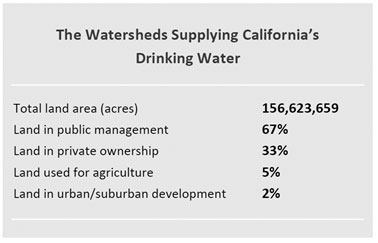
The entire California water supply relies on 157 million acres of land covering 8 states, including the Sacramento, San Joaquin, and Colorado Rivers, and other local streams [Klausmeyer and Fitzgerald, 2012]. Because a majority of water collection is from surface water, land use surrounding these areas is important. Klausmeyer and Fitzgerald [2012] analyzed 80 percent of California residents from 30 of the most populous cities, as well as the watersheds surrounding their sites of collection, such as rivers and reservoirs. Out of all 30 cities, Los Angeles’ water supply area totaled about 146 million acres [Klausmeyer and Fitsgerald, 2012].
Figure 2: Klausmeyer and Fitzgerald [2012] show which land areas receive the most water.
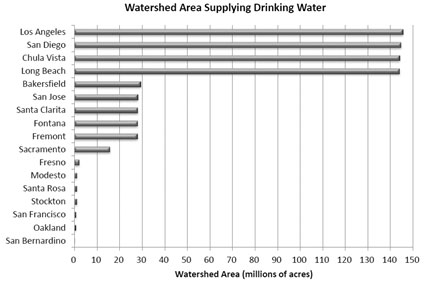
Figure 3: Klausmeyer and Fitzgerald [2012] compare watershed area used for drinking water by each of the top 30 cities in California.
Aqueduct System and the LADWP
The first aqueduct system was completed by the Los Angeles Department of Water and Resources (LADWP), in 1913. It diverted water from the Owens River to the city of Los Angeles for domestic and developmental use. In just 11 years of appropriation Owens Lake had dried and formed a salt flat [Hill, 2006]. The result of this change was a decrease in air quality due to air-borne particulate matter rising from the lake bed. Los Angeles was forced to irrigate the area because it violated the Clean Air Act.
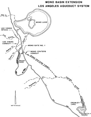
Beginning in 1934, the city of Los Angeles began the Mono Basin Project by purchasing private land and riparian rights to four creeks in the Mono Basin [Mono Basin Geology and Hydrology, 1987; Sax, et al., 2000]. In 1940, the LADWP got permission from the California Water Resources Board to connect the Mono Lake tributaries to the Owens River [Sax, et al., 2000]. Construction of the Mono Basin Extension diverted water from four of the five tributaries feeding Mono Lake, all except Mills Creek. 11 miles of this tunnel was drilled through the Mono Craters; although a revolutionary engineering feat, this diversion dropped Mono Lake vertically 45 feet [LA Aqueduct Centennial, 2015; Mono Basin Geology and Hydrology, 1987]. According to the Mono Basin Geology and Hydrology article [1987], the Mono Basin Extension was able to divert 200 cubic feet per second (cfs) and 93,540 acre-feet per year for storage.
According to the LA Aqueduct Centennial article [2015], the LADWP diverted the largest amounts of water between 1947 and 1982. In 1970, the Second LA Aqueduct was built in order to further increase water supply to Los Angeles. This addition to the aqueduct system caused further lowering of Mono Lake, decreased surface area, increased salinity, and caused ecological damage. The Second LA Aqueduct was able to divert, annually, 210 cfs and 167,800 acre-feet for use and storage, a portion of which comes from Mono Lake [Mono Basin Geology and Hydrology, 1987, p. II.7-II.8].
The Mono Lake committee formed in 1978, teaming up with the California Trout and the National Audubon Society, to advocate for ecological, cultural, and recreational preservation of Mono Lake [About Mono Lake, 2015; Hill, 2006; LA Aqueduct Centennial, 2015]. The legal principles they pursued include the Public Trust Doctrine and the California Fish and Game Codes, in order to protect navigable bodies of water and tributary streams and fisheries [LA Aqueduct Centennial, 2015].
In 1990, excessive diversions to Los Angeles ended. Four years later the State Water Resources Control Board mandated a minimum flow requirement based on wet/normal/dry year classifications and required the lake be returned to 6,392 feet above sea level [LA Aqueduct Centennial, 2015]. According to the Mono Lake Committee Website [2015], requirements for Lee Vining Creek are 25-54 cfs, 4.5-6 cfs for Walker Creek, 6-9 cfs for Parker Creek, and 31-68 cfs for Rush Creek.
Figure 4: Mono Basin Geology and Hydrology [1987] illustrates the Mono Basin Extension and how tunnels through the Mono Craters (dotted line) and connects to the Owens River
Public versus Private
The legal debate between environmentalists and the LADWP began because of unequal distribution of water for municipal water supply needs and for sustaining ecological and recreational needs, at Los Angeles and Mono Lake, respectively.
The LADWP argued that water diversions from northern waterways were necessary to sustain population and agricultural development in larger cities. They backed up this claim by utilizing the Water Commission Act, which says appropriation of water should go to activities with the highest value [Public Trust Doctrine, 2015], which they considered domestic use. By creating an aqueduct system for water supply they also argued in favor of harvesting hydroelectric power from energy flows: pipes, tunnels, dams, and reservoirs, in response to gravity.
Environmentalists argued the diversion of water was degrading Mono Lake and advocated support of a public trust doctrine to protect shores, lake beds, and waters [Sax, et al., 2000]. A public trust doctrine is a principle that says the state must preserve and protect natural resources in an area in order for the public to enjoy and have access to them. This type of doctrine has existed since Roman times and was created to protect the values and rights of the public so states could not benefit from giving away resources only to individuals in a higher class [Public Trust Doctrine, 2015]. Instead of individuals having ownership of a particular resource, specifically water, it is maintained for all.
Applying the public trust doctrine principle to the water controversy over Mono Lake was the main victory for restricting water diversions to Los Angles. The California Supreme Court recognized the significance of the doctrine and expanded it to include recreational and aesthetic values, in addition to natural resources, specifically navigable bodies of water [Public Trust Doctrine, 2015]. They also took into account that the public trust doctrine and the water rights system had developed independently of each other [Sax, et al., 2000]. The Court ruled that the State Water Board had not taken into account the trust before allowing diversions, and, according to Sax, et al. [2000], the State should supervise and control both Mono Lake and its tributaries. Because diversions were necessary, and curtailing all of them would be costly, the LADWP was able to continue their activities if they reduced the amount of water appropriated. Despite the victory, it took 11 years to enforce a healthy lake level, which originated from the California State Water Resources Control Board [Public Trust Doctrine, 2015].
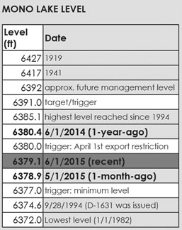
Figure 5: Mono Lake Committee [2015] table shows important dates and water levels for Mono Lake.
Conclusion
The history of Mono Lake’s uniqueness can be attributed to the geologic processes that have formed it into a terminal basin. Without having a source of outflow it requires a specific amount of water to keep it functioning, especially to the standards of being most productive in the world. Whether or not water should be allocated to humans or to the environment increasingly makes water use in this area more controversial, considering factors associated with population growth and climate change. However, with the continuing help of the Mono Lake Committee and protection of the State there is hope Mono Lake will return to pre-diversion levels. Current lake level is at 6,379 feet and management has projected a goal of raising those levels to 6,392 feet. After success they plan to set a new, higher goal.
Bibliography
About Mono Lake. (2015). Retrieved June 14, 2015 http://monolake.org/about/
Hill, M. (2006). Mono Lake: The "Dead Sea" of the West. In Geology of the Sierra Nevada (pp. 323-333). Berkeley and Los Angeles, California: University of California Press.
Klausmeyer, K., Fitzgerald, K. (2012) Where Does California’s Water Come From? The Nature Conservancy of California. Retrieved June 14, 2015.
LA Aqueduct Centennial 1913-2013. (2015). Mono Lake Committee. Retrieved June 14, 2015, from http://www.monobasinresearch.org/images/2013AqueductCentennialFactSheet.pdf
Mono Basin Geology and Hydrology. (1987) II, III, V. (pp. II.1-III.21, V.1-V.4). Los Angeles, California: Los Angeles Department of Water and Power. http://www.monobasinresearch.org/onlinereports/ladwpmonobasingeologyhydrology.pdf
Sax, J., Thompson, B., Leshy, J., and Abrams, R. (2000). Legal Control of Water Resources: Cases and materials (3rd ed., Vol. American Casebook Series). St. Paul, Minnesota: West Group.
The Public Trust Doctrine at Mono Lake. (2015). Mono Lake Committee. Retrieved June 14, 2015, from http://www.monobasinresearch.org/timelines/publictrust.php
[Return to Research Projects] [Return to Sierra Home]