Geology and Natural Heritage of the Long Valley Caldera
Issues Surrounding Proposal for Nuclear Waste Repository at Yucca Mountain
Alejandro Gomez
Abstract
In this report, several issues are explored which pertain to the federal government’s proposal to use Yucca Mountain, in southern Nevada, as the site for a radioactive waste repository. If the project were realized, Yucca Mountain would house all of our nation’s high-level radioactive waste from commercial and national defense operations. The project would be one of unprecedented length, as the waste would have to be safely stored until it reached a stable state. Specific topics of interest will include the origins and future of nuclear waste, as well as the political and environmental factors that will determine whether or not Yucca Mountain is approved for use as a geologic repository.
Creation and Storage of Radioactive Waste
If Yucca Mountain were to be deemed a suitable site for a nuclear waste repository, the Department of Energy (DOE) would dispose of two different forms of waste there. The first kind is spent fuel rods. Nuclear fuel rods contain uranium that has been extracted from ore, enriched, and made into pellets before being placed into a nuclear fuel assembly. Once in place, nuclear power plants use the fuel to produce electricity. The fundamentals of the system are the following: The rods contain fissionable nuclei. In other words, these nuclei can be split, causing a release of energy. This release of energy heats water, which surrounds the fuel rods in the reactor core, and then the water is transported to another chamber where it is has room to expand into a gaseous state. This steam is in turn used to power an electricity-generating turbine. This electricity finds its application in many sectors, including powering homes across the country. There are currently 30 states with commercially operating nuclear power plants. Between these there are 61 total plants, and between those there are 99 total reactors. Depending on its size, a single reactor may contain thousands of fuel rods, and these are spent at a rate of roughly six tons per day. Since the dawn of nuclear energy, the United States has accumulated approximately 30,000 metric tons of spent fuel rods from its power plants (Whipple, 1996).
The second form of waste that Yucca Mountain may house in the future is waste remaining from the reprocessing of spent fuel. This consists of the extraction of certain isotopes from the spent fuel. These isotopes can then be re-used as fuel in a nuclear reactor. Though this sounds thrifty, reprocessing is no longer practiced commercially in the United States because it creates large amounts of radioactive waste. It has been and still is however, practiced by the DOE in our national defense programs.
The Nuclear Regulatory Commission (NRC) considers both of the aforementioned forms of waste materials to be "high-level radioactive waste." These materials are potentially very dangerous to people and the environment by virtue of the highly radioactive fission products that they contain, and as such, must be handled very carefully and stored in isolation until they are deemed harmless. One issue here is the length of time required before the radioactive decay of these products can be carried to completion. Some radioactive materials have half-lives lower than 30 years, such as krypton-85 (10 years) and strontium-90 (28 years). On the other hand, plutionium–239’s half-life is 24,100 years. A "half-life" is the amount of time it takes for half of the atoms of the parent isotope (the radioactive isotope) to decay into stable daughter isotopes. The rate of decay is generally constant and proportional to the amount of parent isotope atoms remaining. It is important to note that before a radioactive material can be considered non-hazardous, it must go through 10 half-lives, meaning that a radioactive product such as plutonium–239 would have to be isolated for at least 241,000 years while it decays into a harmless isotope (in this case, uranium–235). To provide a sense of the hazard of this particular material: It has been estimated that as little as a milligram of weapons grade plutonium–239, inhaled as plutonium oxide dust, would be sufficient to cause cancer in a human being (Cohen, 1990).
For the time being, these waste materials are stored on-site at the power plants and facilities where they are produced, but this is by no means a permanent solution. While these facilities can in theory be maintained indefinitely, there are many risks associated with keeping large amounts of radioactive waste in surface facilities. The tanks that house the waste are subject to corrosion and other environmental stresses, and some of these have already failed in the past. Because the facilities are on the surface, materials escaping the tanks have the potential to be carried by runoff and contaminate groundwater and streams. Exposed to the biosphere, these facilities would be even more dangerous during a seismic or volcanic event, during which many tanks could be ruptured and there would be nothing standing between the released radioactive materials and the environment.
Politics of Disposal
It is with such risks in mind that several countries have determined that this method of storage is not viable in the long term. Rather, the waste must be isolated for very long periods of time, upwards of 10,000 years. In fact, the National Academy of Sciences has recommended that the time frame for protection of the waste must be closer to a million years. Never has such a durable disposal program been attempted in human history, and initially there was debate about what the best location for such a program would be. Disposal beneath the ocean floor and disposal in outer space, among other options, were considered before scientists around the world came to the conclusion that the answer lies in geologic disposal. This entails keeping the waste in a facility deep underground, called a repository. The Nuclear Waste Policy Act was passed in 1982, allowing the DOE to begin formally identifying potential sites. By 1987, it had narrowed its sights on one location in particular: an area of federally owned land 100 miles north of Las Vegas, called Yucca Mountain. There are several geologic attributes of the location that make it favorable as a repository site, and these will be examined later, but there are also non-geologic reasons for why the government chose this location. The first is that no one lives on, or even very near to Yucca Mountain. Yucca Mountain is quite out of the way of civilian life, as would be the operations that may be destined for it. As a result there is not likely to be much civilian opposition to said operations. Another reason why the site may have been chosen is that it is on federal land. The government owns this land because it is adjacent to the Nevada Test Site, where nuclear weapons were tested until the 1990s. The federal government would have had to buy land at any of the other potential sites, and is therefore saving money by choosing Yucca Mountain. President Bush signed House Joint Resolution 87 in 2002, allowing the DOE to begin site characterization of Yucca Mountain. The United States has spent at least $1.7 billion on these studies (Whipple, 1996), which will determine whether or not this is a safe location for a radioactive waste repository. If it is indeed found to be a suitable location, the DOE may apply to the NRC for a license to begin construction of the repository. The State of Nevada may reject the proposal, but their refusal can be overridden by a congress.
Yucca Mountain - Site Characterization
Yucca Mountain is a ridge several hundred meters tall, and 29 km long, mainly composed of welded volcanic ash, or "tuff" (Whipple, 1996). The area has a dry climate, getting an average of 165 mm of rain per year (Stuckless and Dudley, 2002). Less than 5% of this precipitation infiltrates the water table, as most of it evaporates, runs off, or is absorbed by plants. Another favorable attribute of the location is its unusually deep water table. It is on average about 600 meters beneath the surface. These factors are key to the suitability of the site because water is the primary mechanism by which radioactive contaminants may be transported from a repository (U.S. DOE, 2003).
Studies
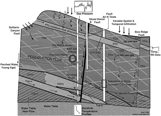
The primary focus of studies at Yucca Mountain has been on the unsaturated zone above the water table, mainly because this is the part of Yucca Mountain where the underground tunnels would be built to house the radioactive waste. To date, the DOE has built two underground facilities with access to the mountain in order to perform these studies. One is a 7.6 km by 7.6 meter lab, which was constructed between 1993 and 1997 and is called the Exploratory Studies Facility (ESF). The other study facility is a 2.7 km by 5 meter tunnel that runs northeast to southwest across the mountain. This tunnel was finished in 1998 and is called the Enhanced Characterization of the Repository Block (ECRB). According to the DOE these labs are used to study the properties of the rock and the behavior of water near the potential repository, which they accomplish by employing three kinds testing: surface-based, underground, and laboratory. The very construction of these facilities also gives scientists an opportunity to assess the strength of the rock. Because of these facilities and the digging of boreholes to extract cores from the mountain, the DOE has been able to acquire much data on saturation, moisture, geochemical environment, and temperature of the mountain, among other things, and this data can be used to calibrate a variety of models (Bodvarsson et al., 1998). Below is a cross-section of the mountain taken from Bodvarsson et al. (1998), that was created using the data from those tests:
Figure 1. A schematic cross section through Yucca Mountain showing some of the field data being collected from boreholes and the EST
Of course the biggest goal with these studies is to determine the potential geologic repository’s capability for isolating radioactive materials over long periods of time. It is quite likely that radionuclides (radioactive elements) will eventually be leached out of the repository, and it is important to have a timeframe and an idea of the magnitude for this scenario (Keller, 1999). DOE scientists are engaged in analyzing a computer model that shows the flow of water on and from Yucca Mountain, and can be used to estimate the amount of radiation that a local farmer 10,000 years down the line might be exposed to. The DOE claims that the amounts would be far below the standards for public health and safety (less than a yearly dental x-ray examination). The problem is that there are many things factoring into the actual situation that are difficult to quantify. Some factors can be quantified with sufficient accuracy, such as the content of the waste and the dispersion of radionuclides in the groundwater (Whipple, 1996), however there are also several unknowns that cannot be ignored. Among these are the actual rates of water infiltration at different parts of the mountain. These rates vary seasonally, water penetrating less deeply into the subsurface during the summer than in the winter due to higher rates of evapotranspiration in hotter weather (Stuckless and Dudley, 2002). This varies still more depending on climate changes, weather patterns from year to year, and the intensity of individual rainstorms. Additionally it should be noted that while mechanisms of radionuclide dispersal are relatively well understood, the exact behavior of these particles depends largely on the area that they are moving through. In other words they will tend to be transported more quickly in water flowing through fractures than in water seeping through the rock itself. Unfortunately it is difficult if not impossible to characterize the mountain at a high enough resolution to know the ratio of water moving through fractures vs. seeping through the actual rock.
Another area of research centers on the materials that should be used to store the radioactive waste. The waste would be packaged in containers before being placed in underground tunnels, and it is essential that those packages be long lasting. One challenge is that an unsaturated environment like the one chosen for the repository is home to conditions that actually encourage oxidation (Whipple, 1996). A solution to this problem might be found in the use of ceramic materials for the containers, being as ceramics are already oxidized. Nonetheless, there are two main factors that contribute to the deterioration of waste packages, namely: direct water contact and humidity. Unfortunately the volcanic tuff that Yucca Mountain is composed of contains much water, causing the inside of Yucca Mountain to be about 99 percent humidity, but there are some strategies for coping with this. One such strategy is ingenious but involves a trade-off. The radioactive waste can be used to heat surrounding rock to above the boiling point of water, eliminating humidity levels and water accumulations in the repository (Whipple, 1996). While this sounds ideal, the same increased temperatures would contribute to package deterioration, so the DOE has yet to determine the ideal temperature at which to maintain the facility.
It has been very important to consider and study the factors by which radioactive materials could be released from the site. Some processes, besides hydrological ones, which could compromise the integrity of the repository include earthquakes and volcanic activity. While historical trends may be used to imply that such disruptions are improbable, a solid understanding of the geological, hydrological, and volcanic context of Yucca Mountain is crucial to making informed decisions about its programs. Thus, the following sections will cover information gathered from studies pertaining to those three contexts.
Geology
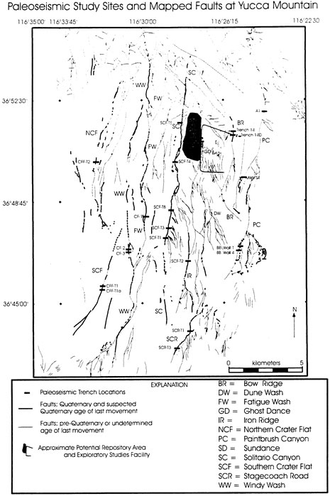
Yucca Mountain is an area called the Great Basin, which is the northernmost part of the Basin and Range province and occupies most of Nevada. The Basin and Range has been formed by shortening and extending of the crust, and the current tectonic environment is dominantly a result of extensional tectonics. Yucca Mountain itself is made of a group of block-faulted ridges that run from north to south. The basin and range faulting has resulted in several faults which cut through Yucca Mountain, running parallel with the ridges. These are mapped in the image below (Stuckless and Dudley, 2002):
The most significant of these faults, insofar as the repository plans are concerned, may very well be the Ghost Dance fault, which is marked GD on the map above. Ghost Dance is a normal extensional fault that strikes north and dips 75-80 degrees to the west (Stuckless and Dudley, 2002). This structure basically cuts the proposed repository in half, and as such, the emplacement tunnels for storage of waste-packages would be placed on either side of the fault. Data collection and mapping of fractured rock has been carried out at the ESF, as these data are useful for developing infiltration and permeability models, and can be used to study the stability of the structures within Yucca Mountain. The fractures found have resulted from three general kinds of paleo-stress, resulting from either the cooling of joints, later tectonic joints, and joints caused by erosional unloading (Stuckless and Dudley, 2002). Paleo-seismicity factors into the area’s stability as well, and data relating to this has been collected since the days of nuclear weapons testing at NTS. Probabilistic seismic hazard analysis has been performed in depth and a panel of 18 experts has deemed the future fault displacement hazard at Yucca Mountain to be very low (USGS, 1998). The panel determined that the average displacements expected at the intrablock faults are far below .1 cm for time periods approaching 10,000 years.
Hydrology
Yucca Mountain is located within the Death Valley hydrologic basin, from which water does not flow to the ocean or to any rivers. Recharge of this basin occurs primarily in the northern and eastern highlands. Surface water in the Great Basin is internally drained into playas, springs, and lakes. The relief in this region is dramatic, ranging from 86 meters below sea level at its lowest, to 3,600 meters above sea level at its highest. Death Valley is in the rain shadow of the Sierra Nevada mountain range, and this geographic position is largely responsible for its dry climate. As water-carrying eastbound clouds encounter the western flank of the Sierras, they are pushed upward along the mountain slopes. At higher altitudes the air is less capable of holding water, and as a result the clouds drop the bulk of their load before crossing the summit of the Sierras. As stated earlier, annual rainfall is about 165 mm. The hydrology of the potential repository site itself has been studied extensively. The unsaturated zone underlying Yucca Mountain is divided into 6 main units, each with different properties in regards to water and gas flow through the rock. A very important characteristic or Yucca Mountain in regards to water flow is the potential for natural barriers to water which would otherwise percolate downward and contact the waste-packages. These barriers consist of impermeable layers of rock as well as fractures around the repository that may act to divert water away from the main chambers by capillary action (Stuckless and Dudley).
It does remain a possibility that that water will still reach the repository and leach contaminants into the groundwater. For this reason it is necessary to understand infiltration trends in the vicinity of Yucca Mountain. Net infiltration is how much water percolates deeply enough to recharge the saturated zone, and it is controlled by many factors. Among these are precipitation, topography, soil type and thickness, permeability of rock, and amount of vegetation present in the area. Again, infiltration is more pervasive in the winter months than in the summer months due to lower rates of run-off and evaporation. It is also more pervasive on ridge-tops where the soil is thinner (Long and Ewing, 2004).
One scenario for radionuclide contamination of groundwater that has been suggested involves groundwater rising up to the level of the repository and inundating it. According to the Natural Academy of Sciences however, not only has an evengt like this never occurred before in the region, but there is seems to be no mechanism by which it could happen in the future.
Volcaniam
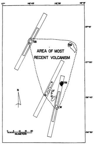
According to (Long and Ewing, 2004) volcanic eruptions have occurred within 50 km of the proposed waste repository over the course of the last 10 million years. Eight of these eruptions are thought to have taken place within a million years ago. As mentioned earlier, there exists no historical record of volcanic eruptions at Yucca Mountain. This does not indicate however that future eruptions at the site are not possible. Because of the lack of a historical record, risk assessment studies of future volcanism and its potential to disrupt the repository are necessarily probabilistic. If the future holds more volcanic eruptions in the region, they would likely be associated with Quaternary centers at Crater Flat, Sleeping Butte, or the Lathrop Wells cone (Hsiang Ho, 1991). The following image, taken from Hsiang Ho (1991) shows areas of highest volcanic risk in and around the area of most recent volcanic activity:
Figure 3. Map outlining the AMRV (dashed line) and high-risk zones (rectangles) in the Yucca Mountain (YM) area that include Lathrop Wells (LW), Sleeping Butte cones (SB), Buckboard Mesa center (BM), volcanic centers within Crater Flat (CF). (Source: Smith et al., 1990a, Fig 7).
The rectangles represent high-risk zones associated with the Quaternary cones that they are drawn around. Yucca Mountain, labeled YM, lies within the high-risk zone for the Lathrop Wells center. A panel of 10 experts studying the volcanic hazards at Yucca Mountain determined that nonetheless, the probability of the repository being disrupted by a volcanic event during a 10,000-year isolation period is around 1 in 7000 (Stuckless and Dudley, 2002). Hsiang Ho points out that while it may be easy to disregard worries about a volcanic disruption of the facility based on these odds, some might argue that any probability whatsoever of such an event occurring poses an unacceptable risk.
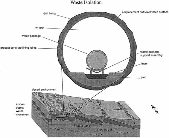
Figure 4. "Defense-in-Depth" The current reference design for the engineered barrier system (from CRWMS M&O, 1997a,b)
Natural Barriers
The DOE uses the term "defense-in-depth" to refer to its strategy for protecting the radioactive waste packages. The idea is that if one of the many protective measures were to fail for whatever reason, there are other measures in place that will continue to do their job and thus make up for the failure. In other words, one unforeseen mishap in a component of the system will not compromise the integrity of the whole system. The combination of natural and engineered barriers to the escape of radioactive contaminants from the facility would be the foundation of the DOE’s broad strategy for containment. Some natural barriers have already been discussed, such as the low water table, capillary action of fractures, and impermeable layers of rock. If water did make it 300 meters down into the repository, it would have to travel yet another 300 meters before reaching the water table – a process that would take a very long time. It is also worth mentioning that there are minerals in the rock below Yucca Mountain that would serve to strain passing water of its radioactive contaminants.
Engineered Barriers
The main appeal of Yucca Mountain as a geologic repository are of course its geologic characteristics, but the planned engineered barriers are perhaps equally important to keeping radionuclides out of the biosphere. The DOE (2003) discusses several of these measures. The first of these is something called a drip shield. Many of these would be put in place to impede water from making it to the waste packages. Then there are the waste packages, which enclose the actual waste and isolate it from the environment. In regards the spent fuel, the fuel pellets are contained inside corrosion-resistant metal tubes called cladding. Finally, the floors of the emplacement tunnels would be made of stainless steel and volcanic rock, helping to prevent the passage of radionuclides.
Conclusion
In conclusion, it remains unclear whether the Yucca Mountain project will ever be fully realized. Research at the facility has already been underway for more than two decades. Whipple (1996) points out that federal financial allocations to the site investigations are declining, as is the amount of people actively working on or supporting the project. It appears that economic reasons are the primary impediments to development of the project, with the urgency of the situation as an environmental and public health issue taking the back seat.
References
Anderson, R.E., compiler, 1998, Fault number 1081, Yucca Mountain faults, western group, in Quaternary fault and fold database of the United States: U.S. Geological Survey website
Bodvarsson, G.S. et al. Overview Of Scientific Investigations At Yucca Mountain–The Potential Repository For High-Level Nuclear Waste. Journal of Contaminant Hydrology 38.1-3 (1999):3-24. Web.
Cohen, B.L. The Nuclear Energy Option. New York: Plenum Press, 1990. Print.
Ho, C.-H.. Risk Assessment For The Yucca Mountain High-Level Nuclear Waste Repository Site: Estimation Of Volcanic Disruption. Mathematical Geology 24.4 (1992):347-364. Web.
Keller, E.A. Introduction To Environmental Geology. Upper Saddle River, New Jersey: Prentice Hall PTR, 1999. Print.
Long, J.C.S., and Ewing, R.C. Yucca Mountain: Earth-Science Issues At A Geologic Repository For High-Level Nuclear Waste. Annual Review of Earth and Planetary Sciences 32.1 (2004):363-401. Web.
Office of Civilian Radioactive Waste Management, U.S. Department of Energy. Overview: Yucca Mountain Project. Yucca Mountain Project (2003): n. pag. Print.
Slovic, P., Layman, M., and Flynn, J.H. Risk Perception, Trust, And Nuclear Waste: Lessons From Yucca Mountain. Environment: Science and Policy for Sustainable Development 33.3 (1991):6-30. Web.
Stuckless, J.S., and Dudley, W.W. The Geohydrologic Setting Of Yucca Mountain, Nevada. Applied Geochemistry 17.6 (2002):659-682. Web.
Wells, S.G. et al. Geomorphic Assessment Of Late Quaternary Volcanism In The Yucca Mountain Area, Southern Nevada: Implications For The Proposed High-Level Radioactive Waste Repository. Geology 18.6 (1990):549. Web.
Whipple, C.G. Can Nuclear Waste Be Stored Safely At Yucca Mountain? Sci Am 274.6 (1996):72-79. Web.
[Return to Research Projects] [Return to Sierra Home]