Geology and Natural Heritage of the Long Valley Caldera
Sierra Nevadan Granitic Bedrock and Ecosystem Regulation
Zoe Doebbler
Abstract
The Sierra Nevada Batholith is a point of geological interest because of qualities related to its unique formation, composition, and geochemistry. Much of this is observable through the specific variety of granitic bedrock that makes up the vast majority of the batholith. The Sierra Nevadan granite is noteworthy for its influence upon the ecosystem on its surface. Although mostly made up of inorganic rock, the Sierra Nevada Batholith is home to many organisms, perhaps most famously groves of gigantic sequoia trees. This paper seeks to explore the characteristics of Sierra Nevadan granite and how it is and is not conducive to plant and animal life.
Introduction
The Sierra Nevada mountain range is located between California’s Central Valley and the Basin and Range Province. Home to a variety of natural wonders, from Mt. Whitney to Yosemite Valley, the Sierra Nevada’s 63,100 sq. km of land area (approximately 640 km north-south, 105 km east-west) encompasses a variety of geological and biological features (U.S. Forest Service). A significant component of the region is the Sierra Nevada Batholith which constitutes the core of the mountain range and is responsible for the granite bedrock prevalent throughout the Sierra Nevada. As a result, the Batholith and its granite are governing factors for the ecosystem growing upon them. Understanding the vegetation of the Sierra Nevada and its limiting factors can reveal characteristics about the bedrock below it.
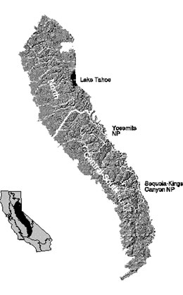
Figure 1. Map of the Sierra Nevada mountain range (state of California in inset). (Davis)
The Sierra Nevada Batholith
Formation
To understand the towering granite spires of the Sierra Nevada visible today, it is important to also understand their history. The Sierra Nevada Batholith is largely the result of plutonism that resulted from a subduction zone which formed at the edge of the North American continent when the ancient oceanic Farallon Plate underneath it (Unger). This subduction is believed to have occurred at the end of the Cretaceous Period, between 115 and 87 Ma (Unger). Rather than consisting of one large pluton, the Batholith was formed by many plutons that emerged during this time range, with older plutons forming in the western half of the Sierra Nevada and the later ones forming in the eastern half (Unger). The distribution in the age of the plutons means that they are "geochemically diverse, but genetically related," allowing for some diversity (Hahm).
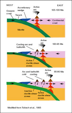
Figure 2. Illustration of the general tectonic setting at the time of batholith formation. (Unger)
Magma composition and granite
The plutons never erupted as lava, leaving the magma inside to cool slowly over tens of millions of years. This is apparent from the granite composition of vast areas of the Sierra Nevada: granite is an intrusive igneous rock that requires a prolonged, subterranean cooling time in order to achieve sizable crystal development. However, simply cooling slowly underground is not the only factor responsible for the formation of granite, especially in large quantities like the Sierra Nevada. In a 1988 report for the U.S. Geological Survey, Paul Bateman posits that "increasing thickness of prebatholithic crust or larger crustal components of parent magma, increasing sedimentary component in crust, and less depletion of the mantle component in such consitiuents as K, Ur, Th with distance from subduction zone" could have affected compositional and isotopic characteristics of the magma that would lead to granite formation (Bateman). Additionally, there is the issue of space when it comes to the Batholith. How could such a massive amount of granite be formed? Creation of space could have occurred through "incorporation of crustal materials in the magma, forcible displacement of wall and roof rocks, stoping, extension across the area of the batholith, and erosion and expulsion of volcanic materials generated in the crust," among other factors (Bateman).
The Effects of the Batholith upon Ecosystem and Landscape
Overview of vegetation
The Sierra Nevada represents an array of plant species, from scrubby sagebrush to towering sequoias. Altitudinal contrasts and their effects are responsible for much of this diversity, with clear distinctions between plant life observed at different elevations, with lowlands in the west showcasing oak woodlands, rising into conifer forests, and then into sparsely vegetated alpine areas (Hahm). Temperature decreases and precipitation increases with elevation, which helps explain the demarcation of vegetational boundaries of the Sierra Nevada. There are still great variations even among areas that are of the same elevation, with "Giant Sequoia, the largest trees on Earth, [growing] in groves adjacent to barren patches where soil is absent and bedrock is exposed" (Hahm). As differences in altitude are not responsible, it stands that soil and bedrock are more influential factors within areas of similar elevation; the different plutons and their varied characteristics, geochemical and otherwise, play an important role in determining the survival of vegetation (see Fig. 3) (Hahm).
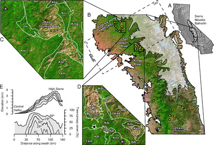
Figure 3. "Vegetation, climate, and bedrock of Sierra Nevada study sites. (A) Shaded-relief map of California with Sierra Nevada Batholith (outlined in black; after ref. 11). (B) False-color Landsat mosaic (SI Text) of central Sierra Nevada Batholith showing sharp altitudinal contrasts in vegetation. Bedrock sampling sites (circles) lie outside the limits of Pleistocene glaciation (transparency; after ref. 12). (C and D) Detailed view of two sampling regions showing simplified bedrock contacts (lines; after refs. 13 and 14), which often separate sparsely and densely canopied plutons. Triangles mark Giant Sequoia groves; star marks Southern Sierra CZO. Letters denote rock types: Granites (Bald Mountain, Kbm; Shuteye Peak, Ksp; Snow Corral Meadow, Ksm; Bear Creek, Kbr; Dinkey Dome, Kdd); Tonalites (Bass Lake, Kbl); Granodiorites (Dinkey Creek, Kdc; Whiskey Ridge, Kwr; Beasore Meadow, Kbe; Camino Creek, Kcc; Mount Givens, Kmg; McKinley Grove, Kmc); Metasediments (ms). (E) Typical range-perpendicular trend in elevation and tree-canopy cover with labels showing percentiles of values observed at each distance along the swath shown in B" (Hahm).
Geochemical controls upon vegetation
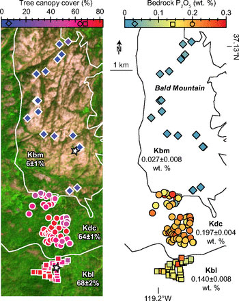
Vegetation is very dependent upon the nutrients available in its soil for growth. For example, phosphorous and nitrogen act like fertilizers when available to plants in the right quantity, and NaCl will inhibit plant growth. Examination of the bedrock beneath the densely vegetated and barren areas of the Batholith revealed significant differences in geochemical properties, particularly differences in phosphorous concentrations (Hahm). As shown is Figs. 4 and 5, areas with greater amounts of phosphorous were significantly more conducive to vegetation than areas with lesser amounts. In this way, the presence of vegetation in some areas of granite and not in other is indicative of the differences within bedrock that may appear uniform upon visual examination.
Figure 4. "Distribution of vegetation across bedrock with differing phosphorus content. (Left) False-color Landsat image of CZO vicinity with georeferenced bedrock contacts from simplified geologic map shown atRight (after ref. 14). Symbol colors match colorbar scales of Landsat-derived, remotely sensed tree-canopy cover (16; Dataset S3 and SI Text), a proxy for primary productivity (Left), and bedrock P concentrations (Right). Vegetated–unvegetated ecotone coincides with boundary of Bald Mountain Granite (Kbm; diamonds), a desert in bedrock P relative to more heavily forested Dinkey Creek Granodiorite (Kdc; circles) and Bass Lake Tonalite (Kbl; squares). Labels show average (±SEM) tree-canopy cover (Left) and bedrock P concentration (Right) by rock type. Stars at Left pinpoint productivity surveys (SI Text)" (Hahm).
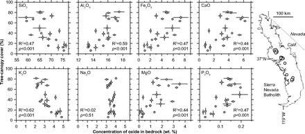
Differences in concentrations of Si, Fe, Al, Mg, K, Ca, and P in bedrock "all significantly correlated with average tree canopy cover," explaining differences in vegetation by "differences in the bulk geochemistry of the bedrock" (see Fig. 5) (Hahm). It is notable that differences in geochemistry did not vary much within plutons, rather between them (Hahm). This is indicative of different types of magma, perhaps only minutely different, being encompassed inside the Batholith.
Figure 5. "Vegetation correlates with bulk geochemistry. Site-wide average tree-canopy cover covaries with average bedrock composition for all elements shown except Na. Error bars are ±SEM. Labels show coefficients of determination (R2) and P values on the correlations based on two-tailed t tests (Dataset S4). Sites span a 186 km lithosequence (Right) of similar elevation and climate through plutons ranging from tonalite to granite" (Hahm).
Weathering
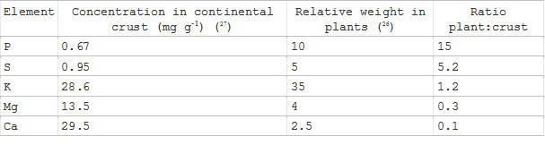
The presence of the aforementioned elements ultimately effects the nutrient concentration of bedrock. These nutrients are made available to plants by being freed from the bedrock by weathering. Since P is the macronutrient required in plants in the "highest concentrations relative to its abundance in the upper continental crust" (see Fig. 5), it is also "the most common rock-derived limiting nutrient in terrestrial ecosystems" and its lack of presence can be an indicator of underlying erosion and weathering within bedrock (Hahm).
Table 1: "Nutrients in Earth’s crust and conifer foliage. Weight relative to weight N in spruce foliage from laboratory and field experiments where nutrients were not limiting" (Hahm).
Weathering is also indicated through mineralogy which "co-varies strongly with bedrock geochemistry," and can also indicate subsurface water-holding capacity and the bedrock’s ability to serve as a substrate for vegetation (Hahm). For example, Si concentrations correlate with an increased presence of quartz and K-feldspar and decreases in both plagioclase content and color index, a measure of mafic minerals (Hahm). Because quartz and k-feldspar are both more resistant to weathering than plagioclase. The weathering of mafic minerals has also been linked to the dissolution of bedrock (Hahm). Within the Sierra Nevada Batholith, then, the increased presence of Si along with a decrease of tree canopy provide indicators of differences in soil qualities, like water retention, that are likely caused by weathering acting upon different plutons in varying ways (Hahm).
Landscape evolution
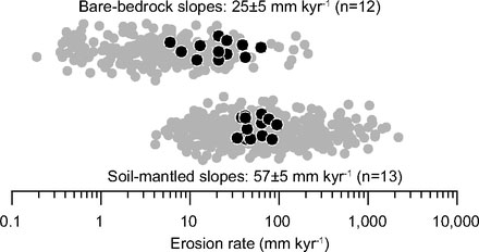
Heavily linked to weathering, particularly erosion, is landscape evolution, or the transformation of a landscape over an extended period of time. The presence of vegetation can speed up this process by creating differences in "soil production and erosion by physical, chemical, and biological processes" (Hahm). Within the Sierra Nevada, areas without significant amounts of vegetation and soil cover erode at a rate greater than two times slower than that of areas with a heavy presence of vegetation and soil (see Fig. 6) (Hahm). The rates of erosion are generally similar within the categories of bare and covered bedrock, even between slopes of different grades. In the long term, it is predicted that the differing rates of erosion will cause changes in relief, with bare bedrock forming the higher points of the new landscape (Hahm). The differences in elevation will ultimately be caused by differences in phosphorous within the plutons: a pluton with a high concentration of phosphorous would presumably attract more vegetation than its low phosphorous level counterpart, and therefore erode at a more accelerated rate.
Figure 6. "Erosion rates versus land cover. A global compilation of cosmogenic nuclide data (gray, after ref. 47) demonstrates that erosion from soil-mantled granitic terrain (Bottom; n = 416) is typically faster than it is from exposed granitic bedrock (Top; n = 250). This is consistent with cosmogenic nuclides in samples from the Sierra Nevada study region (black, with labeled averages ± SEM and number of samples); erosion is more than two times faster on average in soil-mantled terrain (Bottom) than it is in bare rock (Top). Erosion rates (Datasets S6 and S7) are jittered to display their distributions" (Hahm).
Conclusion
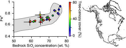
The Sierra Nevada is a rough representative of much of the granite-dominated western U.S (see Fig. 7) (Hahm). While the relationship between bedrock and vegetation is no new concept, the differences within a given type of rock in its component parts has been clearly demonstrated in new ways through studying the Sierra Nevada Batholith and its individual plutons. By understanding the processes at work within and upon the bedrock of this region, it is possible to begin to develop preventative methods against weathering and erosion, or identifying areas at risk of (possibly disadvantageous for humans) landscape evolution.
Figure 7. "Bedrock composition of study sites (circles) and cordilleran granites (gray) of western North America. Average (±SEM) bedrock Fe*, defined as total FeO/(total FeO + MgO), versus average (±SEM) SiO2for study sites (color shows mean tree-canopy cover). Shading in plot shows inner 95% of 538 analyses (after ref. 53) of plutonic rocks in North America’s western mountain ranges (map, after ref.54). Our lithosequence spans nearly the entire compositional range of granitic bedrock in the cordillera" (Hahm).
Works Cited
Bateman, P.C. Constitution and Genesis of the Central Part of the Sierra Nevada Batholith, California. Rep. no. 88-382. Menlo Park, Califoria: U.S. Geological Survey, 1988. Print.
Davis, F., and Stoms, D. Appendix SN. The Sierra Nevada Region. UCSB Biogeography Lab. University of California Santa Barbara, 2011. Web. 15 June 2015. http://www.biogeog.ucsb.edu/projects/gap/report/sn_rep.html.
Hahm, W.J., Riebe, C.R., Lukens, C.E., and Araki, S. Bedrock Composition Regulates Mountain Ecosystems and Landscape Evolution. Proc Natl Acad Sci USA Proceedings of the National Academy of Sciences 111.9 (2014): 3338-343. Web.
Oskin, B.B. World’s Largest Trees Help Explain California Forests’ Bald Spots. LiveScience. TechMedia Network, 10 Feb. 2014. Web. 15 June 2015. http://www.livescience.com/43249-forest-growth-patterns-rock-chemistry.html.
Unger, T.S. Mesozoic Plutonism in the Sierra Nevada Batholith: A Review of Works on Mineralogy and Isotopes in Relation to Models for Batholith Formation. Mesozoic Plutonism in the Central Sierra Nevada Batholith. University of Colorado Boulder, 1999. Web. 15 June 2015. http://www.colorado.edu/geolsci/Resources/WUSTectonics/SierraBatholith/mesozoic.htm.
U.S. Forest Service. Ecological Subregions of California: Section M261E. Ecological Subregions of California: Section M261E. U.S. Forest Service, 2011. Web. 15 June 2015. http://web.archive.org/web/20101205212313/http://www.fs.fed.us/r5/projects/ecoregions/m261e.htm.
[Return to Research Projects] [Return to Sierra Home]