Geology and Natural Heritage of the Long Valley Caldera
Death Valley: A Brief Overview of Natural Processes and Biological Components
Olivia Tuiono
Abstract
Death Valley is a place of extreme heat and desolation, implied by the formidable name. By analyzing the history of the region’s geological activity, an explanation for why the hottest, driest, lowest place on Earth exists where it does is possible. Many are fooled by the name Death Valley into thinking that this area lacks life and diversity, but in fact this place hosts specially evolved life adapted to the extreme environment. Through the analysis of the geological and biological aspects of Death Valley, it is clear that Death Valley was never really dead at all.
death valley
The region in which Death Valley resides has been the center of much scientific interest. Although the name can deter people from wanting to venture there, Death Valley provides striking examples of geological processes. Life within Death Valley is also a popular area of interest in regards to highly adapted animals that have evolved to survive the sweltering climate of the valley and in regards to the inhabitance of Native American tribes for thousands of years before pioneers ever laid eyes on the dry basin.
Native American Inhabitance
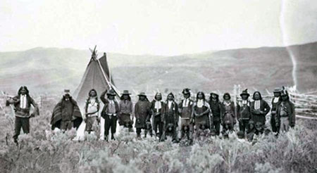
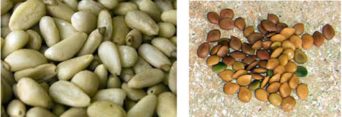
Long before Death Valley was discovered by pioneers from the east, Timbisha Shoshone (image 1) and Paiute tribes called the valley home (NPS, 2014). Their survival relied heavily on seasonal migrations between the valley and neighboring mountains to escape scorching hot summers and freezing winters (NPS, 2014). They lived as hunter-gathers relying on seeds from native plants such as mesquite and piñyon pine as their main food sources (NPS, 2014). Piñyon pine nuts contain essential amino acids and 10% protein (Piñyon Penny’s, 2011)(image 2). Mesquite beans contain up to 17% protein and provide calcium, zinc, and potassium to consumers (Desert Harvesters, 2014)(image 3). In fact, reliance on mesquite as a food source and protection from the sun influenced the Timbisha to view mesquite groves spiritually (Mojave Desert, 2012). The tribes hunted local wildlife such as: bighorn sheep, marmots, rabbits, and lizards. The Timbisha Shoshone even used the surrounding red clays to create dyes for clothing (Mojave Desert, 2012). It’s amazing how the Native Americans were able to successfully survive using natural resources of the valley when the ensuing pioneers only saw death and desolation.
Image 1: Timbisha Shoshone of Death Valley (http://www.crystalinks.com/shoshone.html)
Image 2: Piñyon pine nuts (http://en.wikipedia.org/wiki/Pine_nut)
Image 3: Mesquite beans (http://bluebeetlestudio.blogspot.com/)Pioneer Influence
In 1849, pioneers in search of the California gold coast laid eyes upon the desert valley. Relentless heat, the inability to escape the sun, scarce water resources, and the lack of food caused pioneers to kill their own oxen teams in order to survive and left them unconvinced that this region could provide anything other than death itself (National Geographic, 2012). These experiences were recorded in history, and hence forth the region has been called Death Valley. Death Valley has witnessed gold miners, silver miners, borax miners, and Japanese-American internees that have attested to the Death Valley experience, leaving only remnants of societal existence through broken pottery and shattered glance in the barren landscape.
geographical context
plate tectonic activity
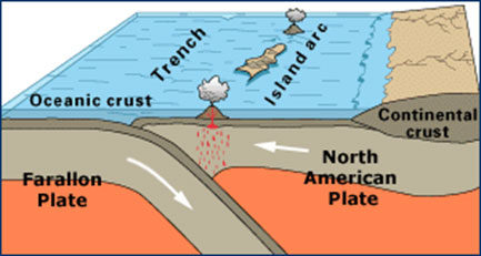
What makes Death Valley such an excruciatingly hot and dry place? Even more, why is it the lowest place in North America? The answers to these questions lie below the Earth’s surface in plate tectonics. About 180 million years ago, a Pacific seafloor plate began to converge with the North American plate (NPS, 2014). As theses plates converged, the Pacific plate called the Farallon Plate began to subduct beneath the North American Plate (image 4) (Blakey, 2014). The plate that subducted was older and denser. The younger, less dense North American Plate was lighter so it stayed above while the denser plate dived below (National Geographic, 2014). This process of higher density material subducting below lower density material is referred to as downwelling, and is also seen in saline lakes and the convergence of cold air with warm air (USGS, 2004).
Image 4: Farallon Plate subducting below North American Plate (http://www.ucmp.berkeley.edu/exhibits/caltrans/index.php)
As the Farallon plate subducted continuously, the size of the magma bodies increased in the mantle. The increase of magma led to eruptions above and below Earth’s surface. Above the surface, volcanoes erupted while underground magmatic eruptions cooled beneath the Earth’s surface creating large intrusive granitic rock formations. Through uplift and a long history of erosion, the granitic batholiths that formed underground were exposed and are what we see in present-day Sierra Nevada Mountains (Hill, 2006).
basin and range formation
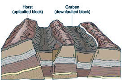
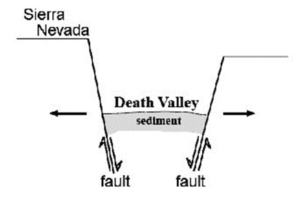
Then 20 million years ago, Earth’s crust began to stretch east to west (Hill, 2006). As the crust stretched, mountain ranges and valleys that run north to south began to form. The stretching of the crust during this time is believed to be caused by contact of the Pacific Plate with the North American Plate (Hill, 2006). The Farallon Plate was sandwiched between the Pacific and North American plates, causing a slight barrier between the two (Blakey, 2014). When the Farallon Plate disappeared for the most part, it allowed the Pacific Plate to move northwest along the edge of the North American plate causing a strike-slip fault (Blakey, 2014). The lithosphere of the western United States was then stretched by the movement of two plates beside each other (Michaelsen, 2014). After the continent stretched, series of normal faults were created throughout the region (Hil, 2006). The Sierra Nevada range began to rise due to uplift of the Sierra block and the simultaneous downdrop of the land to the east of the range (image 5). This process is also referred to as a Horst and Graben formation (Hill, 2006).
Image 5: Horst-Graben/Normal faulting that produces basin and range features (http://www.geogrify.net)
The eastern side of the mountain range rose more steeply than the western side, giving the western side of the mountain range a gradual incline in comparison to the steep incline on the east side (Hill, 2006). This construction of the Sierra Nevada Mountains is crucial to understanding Death Valley’s strange qualities because it allows the Sierra Nevadas to host the tallest mountain: Mount Whitney at 14,949 feet, along with the lowest point in Death Valley at 282 feet below sea level (NPS, 2014). These stark differences stem directly from the uplift/downlift processes that the basin and range province experienced. Death Valley is one of the valleys formed from the continental stretching, serving as an ideal example of the basin and range province of the western U.S. (image 6).
Image 6: Death Valley/Sierra Nevada Horst-Graben process (https://www.e-education.psu.edu/geosc10/l2_p2.html)
weather patterns
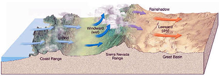
The creation of Death Valley doesn’t necessarily explain why it is the hottest or the driest though. The explanation of these two qualities lies above Earth’s surface, although it is influenced by creations from below the surface. As we mentioned before, the Sierra Nevada mountain range lies to the west of Death Valley. As air from the Pacific Ocean moves towards the eastern inland of the United States, it approaches the Sierra Nevada mountain range and begins to cool due to elevation. As the air cools and forms clouds, it loses its ability to hold moisture. The movement of the cooling air up the mountain range causes precipitation along the mountain range, but as the air moves past the top of the mountains it begins to heat up and dissipates cloud formation (image 7). The air that reaches Death Valley after summiting the Sierra Nevadas is left arid and explains why there is hardly any precipitation in Death Valley, if any at all (National Geographic, 2014). The lack of water to cool the air within Death Valley, along with the lack of water to hydrate Death Valley gives it the hottest and driest traits.
Mining today.
Image 7: Diagram of rainshadow of Death Valley (http://www.stevekluge.com)
topography and hydrology
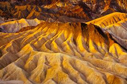
Much of the beautiful scenery of Death Valley is ironically caused by water. Because the land is so dry, when rain occurs it brings along flash flooding due to the lack of vegetation and soil to absorb the water. Flash flooding is the most influential process on Death Valley landscape. In Mosaic Canyon, the canyon was carved by water flow that followed faults within the canyon. In fact, water pathways can help detect faults because water prefers to flow along the weaker fault rock. As flash flooding recurs in the canyon, more debris is moved and marble exposure is increased and polished (NPS, 2014). Another amazing site called Zabriskie Point has been influenced by flash floods, too. This area is made of mudstone that gets loosened when flash floods come into contact with it. Rills are carved in the surface to maximize the rate at which the water can flow downhill with minimal resistance. Zabriskie Point was created by this process of rill creation and continuous use to accommodate rainfall (NPS, 2014). The rills became deeper, forming the beautiful gullies presently seen there (image 8).
Image 8: Zabriskie Point, example of gullys formed from rills (https://contest.thesca.org/photo/sunrise-over-zabriskie-point)
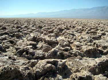
The most remarkable places in Death Valley are within the lowest places of the valley, though. Sights such as Devil’s Golf Course and Badwater Basin were originally covered by melted glaciers of the last Ice Age. Because Death Valley is so low though, due to geological processes, the water only exited the valley through evaporation. As the water evaporated over thousands of years, salt was left behind. After further evaporation, the leftover salt began to crystallize. Because Devil’s Golf Course lies above sea level, the water that reaches this area does not linger long because it is always searching for the lowest point. The crystallized salt mixed with silt from the neighboring mountains is able to form peculiar mounds and spires that never get smoothed over by constant water contact (image 9)(NPS, 2014).
Image 9: Devil’s Golf Course, salt evaporate formations (http://minystock.deviantart.com/art/The-devils-golf-course-51859619)
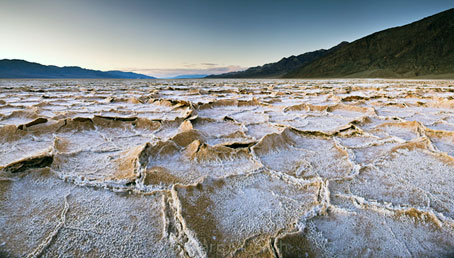
Badwater Basin hosts the lowest point in Death Valley at 282 feet below sea level (NPS, 2014). Water that leaves Devil’s Golf Course is headed directly for this point, causing the basin to serve as an ephemeral lake. Just as in Devil’s Golf Course, the water evaporates leaving behind salt. The standing water erodes crystallized salt formations to a flat surface leaving behind dried polygonal salt cracks (image 10) (NPS, 2014).
Image 10: Badwater Basin salt flats (http://www.luminescentphoto.com/blog/2013/01/25/photo-of-the-day-sunrise-at-badwater//)
hydrological deposits
Mentioned previously, Death Valley was inhabited by gold, silver, and borax miners. The miners sought out naturally deposited ores created by underground hydrological activity. As the mantle heated underneath Earth’s surface, water vapor also heated up allowing it to carry particles of various elements and compounds closer to the surface. When the water began to cool, it precipitated minerals within it at certain temperatures, leading to the congregation of minerals in large deposits that could be mined. Interestingly, the presence of water drastically shaped Death Valley’s most renowned desert characteristics.
Ecosystems of Death Valley
Topographic Zonation
At the lowest point of elevation in the basin, no vegetation is found. Dry land 282 feet below sea level exemplifies the lack of water in the basin. Without water, basic life forms such as plants cannot survive, causing the inability of larger life forms to exist. The highly concentrated amount of salt in the basin also decreases the ability of plant and animal life to exist in this area. Bacterial life has been found deep within the Earth though, suggesting evolution of life in harsh climates (NPS, 2014).
the lower sonoran
The Lower Sonoran ecosystem consists of the lower 4,000 feet of Death Valley (DesertUSA, 2014). 400 feet above sea level is the point at which cacti begin to persist. Desert holly and creosote bushes are also dominant vegetation typically found in alluvial fans (National Geographic, 2014). Desert holly has evolved short roots that allow it to survive off of ephemeral water. Because ephemeral water exposure is unpredictable, desert holly can go a long time without water which allows it to grow in the hot and dry alluvial fans that experience fresh flowing water from the mountains (DigitalDesert, 2014). Desert holly can tolerate high amounts of salt content too, allowing it to grow better than creosote bushes that cannot tolerate high levels of salt (NPS, 2014). Pickleweed has adapted long roots that penetrate underground saturated water zones. They have an extremely high tolerance to salt and can be found growing close to the Death Valley salt flats (DigitalDesert, 2014). Animals that are found in this region are: scorpions, sidewinders, ravens, roadrunners, kit foxes, and kangaroo rats (NPS, 2014). All of these animals are very small in size which reduces the resources needed to survive. The kangaroo rat lives nocturnally to avoid daytime heat. Kit foxes have evolved big tails and ears to maximize heat transfer from blood vessels to keep a cooler body temperature (DigitalDesert, 2014).
The Upper Sonoran
The Upper Sonoran ecosystem ranges from 4,000-8,500 feet above sea level (DigitalDesert, 2014). Piñyon pine and juniper trees coexist at this elevation, along with sagebrush and other shrubbery (NPS, 2014). Antelope ground squirrels, desert woodrats, black-tailed jackrabbits, horned lizards, chuckwallas, and tarantulas are the typical fauna found in this region (NPS, 2014). The increase in elevation allows for more exposure to water along with a decrease in temperature compared to that of the basin. Species differ, but there is still a limit on food and water sources that keeps the size of the animals in this area small, too (DesertUSA, 2014).
The Transition Zone
The Transition zone is defined between 8,500 -9,000 feet in elevation where sierra juniper and mountain mahogany thrive (NPS, 2014). Mule deer, bobcats, cougars, and coyotes are found within this range and the Upper Sonoran ecosystem (DesertUSA, 2014). Because the temperature is much cooler, it is possible for larger animals to exist without risk of overheating. The more hardy plant life provides a better diet for the mule deer, which serve as great food sources for the larger predators (Miller,1946).
The Sub-Alpine
The Sub-Alpine zone starts at 9,000 feet above elevation where bristlecone pines and limber are the dominant plant life (NPS, 2014). The high elevation reduces the ability for life to proliferate, so highly evolved species of plants such as bristlecone pines than can survive thousands of years are able to live here. Bighorn sheep are the most notable inhabitant of this region due to their ability to eat any plant and lack of predators due to elevation (NPS, 2014).
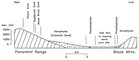
Elevation
These zones are generalized because they are so hard to rigidly define. The main correlation between life and Death Valley lies within elevation and water access (image 11). Extremely low elevation reduces the chances of water exposure, along with a great increase in heat exposure. As you move up Death Valley in elevation, the decrease in temperature and higher chances of water exposure increase allowing insects, mammals, and reptiles to exist. At the highest areas of Death Valley elevation reduces the ability to survive based on oxygen levels, although precipitation increases and temperature decreases. If you could imagine it, the life found in Death Valley would form a graph that resembles an upside-down parabola with biological activity on the y-axis and elevation heights on the x-axis.
Image 11: Water access and elevation relationship (http://palynology.geoscienceworld.org/content/24/1/49/F2.expansion.html)
Conclusion
Death Valley is an amazing place with a name that can trick you into believing nothing exists there other than blistering desert and ghost towns. Death Valley has so much to offer though, from extraordinary geological landscapes like Zabriskie’s Point to its harshly constrained ecosystems. Geological processes directly contribute to climate formation, which then exerts a direct evolutionary pressure on life within the valley. Death Valley was mistaken by those first pioneers to experience it. The heat was not mistaken, but the inability to live was. Death Valley serves as a prime example of Earth’s never-ending activity through land formation and deformation, along with the never-ending perseverance of life to inhabit the most undesirable of lands.
references
Blakey, R. (Blakey). Geologic history of the northern Sierra Nevada. Retrieved from website
Death Valley National Park: Description (DesertUSA). (n.d.). Retrieved June 12, 2014, from website
Desert Harvesters (n.d.). Desert Harvesters: Appreciating the Native Foods of the Southwest Mesquite (English). Retrieved from website
Feller, W. (DigitalDesert). Death Valley Ecosystems. Retrieved June 9, 2014, from website
Feller, W. (DigitalDesert). Plants in Death Valley. Retrieved June 10, 2014, from website
Hill, M. (2006). Great is Granite. In Geology of the Sierra Nevada. Berkeley: University of California Press.
Michaelsen, J. (n.d.). Basin and Range Region. Retrieved from website
Death Valley National Park. National Geographic. Retrieved from website
National Park Service (NPS). Death Valley National Park (U.S. National Park Service). Retrieved June 9, 2011, from website
Piñyon Penny’s. Pine Nut Varieties. American vs. Imported Pinenuts. PineNut.com. Retrieved from website
Timbisha Shoshone-Death Valley Native Americans. (n.d.). Retrieved from website
[Return to Research Projects] [Return to Sierra Home]