Geology and Natural Heritage of the Long Valley Caldera
Volcanic Processes, the Resulting Landforms, and What These Mean To the Residents Nearby
Erin Tarnowski
Introduction
Ancient Eruptions
Volcanoes present many hazards to the populations nearby. Famous historic examples such as the Italian city of Pompeii can attest to this as the damages Mt. Vesuvius rained in on the city are preserved in the ancient streets in the form or air fall and pyroclastic flows that consumed the people of Pompeii.
New Understandings, New Technologies
Today we are fortunate to have newer understandings of the earth around us. We can now understand where volcanos occur in relation to plate tectonic settings and how active the volcanoes are likely to be. We know from studying magma types that Silica, and gas content, and calculating the amount of magma can help us analyze the level of danger a volcano can present. We can track warning signs around a volcanic area such as seismic activity, the popping up of fumaroles, and measuring deformation. We can turn to seismometers, Global Positioning Satellites, and measurements and records of the types of gasses being emitted from underground. With all of this new knowledge, volcanologists of the U.S. Geological Survey have compiled a threat level system a volcano presents based on certain warning signs around a volcanic area. This system helps predict when an eruption might occur and helps authorities decide when it’s time to evacuate the area to prevent casualties.
This isn’t an exact science though, like most sciences there’s always sources of error. However, there’s a significant risk factor to being wrong when it comes to volcanic predictions. It’s important to note that there’s a lot more than meets the eye when it comes to volcanic processes and how to prepare for the hazards they present to residential life.
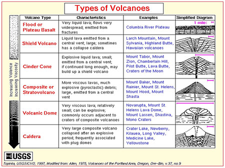
TYPES OF VOLCANOES
Different types of volcano shapes indicate a different type of magma/lava that is responsible for the shape. For example this chart shown here:
summarizes the different types of volcano shapes and their names with a schematic sketch of what each type might look like. Note that the arrow along the side denotes increasing violence/viscosity as the list progresses. One thing to make note of is that a Caldera is in fact a collapsed volcanic feature but may continue to have activity as magma gathers underground.
Viscosity means Violence?
By technical definition viscosity isn’t really a synonym for violence but it may as well be to a volcanologist. Viscosity refers to the thickness of the magma, how easily it will or won’t flow. Thicker, stickier magmas have been found to contain high amounts of silica. Silica molecules tend to form long polymer chains that aren’t easily broken. High silica magmas/lavas are said to be Rhyolitic and can contain upwards of 70% silica. The intrusive version of a Rhyolite is a Granite. Intermediate igneous rocks such as Andesite (intrusive equivalent: Dacite) contain between 63-52% silica. Mafic rocks such as basalt (or gabbro) contain 45-52% silica. The lower the amount of silica the less polymer chains that form on a molecular level and the less dangerous the lava will be. Low viscosity magmas/lavas would form flood basalts and shield volcanos. Intermediate magmas/lavas would form cinder cone or composite volcanoes, and high viscosity magmas will make composite volcanos too and calderas.
Volatiles
Another factor that determines the violence of an eruption is volatiles. Volatiles are gases dissolved in the magma. The primary gases are H2O and CO2. The reason gas dissolved in magma is so dangerous is because as the magma wells up in the magma chamber, the pressure increases and the gas separates out of solution. The decreased volume results in faster moving molecules, and basically the gas needs to escape. Gas bubbles in a sticky viscous magma are what makes a lava violent and dangerous.
Volume
The last thing that makes a lava dangerous is volume. The amount of magma can make a difference of how dangerous an eruption with be. If the amount of magma erupted never reaches beyond the edges of the volcano there will be minimal impact. A massive amount of lava though can cause damage for kilometers in all directions. Another important thing to consider is population densities around the volcano. A volcano erupting in the sea can cause less damage when compared to places like Tokyo, Japan. That’s not to say that the eruption can’t cause other problems, but that will be discussed in the next section.
hazards
The hazards I’d like to discuss are specific to the Long Valley Caldera of the California/ Nevada area. The types of lava that would be produced here are Rhyolitic and andesitic in composition, which means that the magmas have a relatively high silica content.
Earthquakes, Faults, and Fissures
The movement of magma underground can result in faults and fissures and can cause seismic activity. Faults are breaks in the rock, where rock is under stress and shows signs of rock sliding against rock in the fault itself. Seismic activity can occur in faults and/or trigger dangerous landslides. Seismic activity is the result from the rocks grinding against each other which translates to shaking in the earth or earthquakes. A fissure is a crack or split in the rock from which magma and steam can erupt out of. A couple ways to tell an old fissure from a fault is to see if there is any displacement on either side of the break, if there is dramatic movement, it’s probably a fault. Another way to tell is observe the rock on either side of the break. A fissure may show magmatic banding parallel to the break. This would be a result of the eruption thrusting the lava upward along the walls of the break.
Earthquakes can trigger tsunamis too. When the earthquake happens in the ocean it's probably near a mid ocean ridge. The earthquake causes the water to recede, dropping the water level at first. Not very long after the water comes back with force. Tsunamis can devastate coastal cities, both fatality and damage wise.
Gas Emissions
The fractures created around a volcano can allow a pathway for steam to get to the surface. The steam occurs when the magma underground comes into contact with aquifers. The heat of the magma causes a phase change from liquid to gas. Anything else that was in the water like sulfides, chlorides (just to name a couple) and such become gas as well. The molecules in a gas are moving at a fast rate and a small volume that the gas is contained in can cause a high pressure. Near fault has more space for this gas so the gas escapes into the space to decompress. The gas can travel all the way to the surface. The area where the gas reaches the surface is called a fumarole. The steam released here as one can imagine can be very hot and can carry toxic gases. The threat this presents is obvious, one wouldn’t want their house to be built on a fault or even near one if there’s a threat that these gases could leak into someone’s home and poison a family without them even knowing. If a fumarole occurs out in the open it can be relatively harmless. But closed spaces where the toxins can linger could kill people, animals and even vegetation. Near Mammoth Mountain, the Horseshoe Lake area experiences a large amount of vegetation death as the gases became trapped under the snowfall in the area and then the gases were trapped in the soil essentially choking the plant life. The major gas recorded in this area is CO2. It’s not all bad news though, the energy stored in the steam in the form of heat can be converted to energy. This energy can be used to supply homes with electricity. This kind of energy is called geothermal energy.
Landslides
Volcanoes can also cause other events like landslides. The shaking from the movement of magma can move rock around and cause loose rocks to fall or flow. Big boulders to fine clay can flow in a wet or dry fashion. The movement of magma can create fractures that allow for eruptions on the sides of volcanoes, even fumaroles which can carry ions that can alter the surrounding rock. Landslides can cause fatalities, property damage, and block streams and roadways. Blocking water flow can be a big deal especially in communities with little rainfall that depend on the few rivers they do have.
lava flows
Lava flows can obstruct escape routes and streams as well. A lava flow can present difficulties to the nearby residents when it spills over onto residential property or into roadways. Slow flows are dangerous but less so than faster ones. Either way lava flows are hot and can cause fires and burn forests or buildings that they come into to contact with. Once the lava solidifies it can become another nuisance entirely based on the silica content. Rhyolites contain quartz which is harder to mine through but basalts weather away relatively easily.
fire rocks flow
When air fall debris falls out early and gathers on the steep sides of a volcano, with the assistance of gravity, a pyroclastic flow occurs. Pyroclastic flows have the potential to block roadways, bury homes, and burn property. A pyroclastic flow is made of effusive volcanic material. The flow can be dangerous when it’s a large flow with velocity. A pyroclastic flow is similar to a mud flow but its hot rocky material.
Tephra and air fall
When a volcano erupts, the first part of the lava instantly cools to glass and is blasted into the air by the heat below. As with the pyroclastic flow discussion above, i mentioned that the heavier bits fall out and become a flow but the remaining lighter pieces are carried by winds. This debris that is carried is called air fall (simple enough) and can also be called tephra. I should also clarify that the pieces carried aren’t always small pieces, the force of the explosion can dictate how high or how far these pieces are carried. Tephra can be carried miles and miles (or kilometers and kilometers) out from the volcano. Air fall can come in various sizes and can fall for weeks before a lava flow occurs. The pieces falling are called lapilli. The ash and lapilli aren’t very dangerous, they can end up being more annoying and disruptive than harmful. The ash flow can gather like snow, block roads and just in general disrupt daily life for residents near the volcano.
WATCH OUT! (MONITERING TECHNIQUES)
While volcanoes can cause many different things to happen and produce many different products, through extensive studies, scientists have found some signs that a volcano will erupt. Turns out the activity can be tracked and increasing frequency of events means the (not so) dormant beast is about to wake up. We can tell that the alarm is about to go off by measuring and recording the area’s seismicity, tracking deformation via global positioning satellites, recording the gas emission types and amounts, and watching for the emergences of lava domes.
Earthquake!
The areas seismicity is a big clue about when the volcano will blow. Scientists can also tell whether the shaking moves through a liquid or a solid. When an earthquake occurs there’s an initial wave called the P-wave (primary) and there’s a second wave called the S-wave (secondary). S-waves can only travel through solids, but P-waves can travel through liquid and solids. Scientists can triangulate the focus of an earthquake by using 3 different seismometers and using the time differences to calculate where it occurred. As stated above, a lot of consequences happen because of earthquakes near a volcano, to be able to use that and rack when it’s going to erupt is an amazing advance compared to the days of Pompeii.
It’s Deformed
In accordance with the earthquake theme, using the GPS network (global positioning satellites) we can track, measure, and record how much deformation is occurring around the volcano. Things like displacement on faults and bulges from resurging domes of calderas are all measurable forms of deformation. The satellite works by using multiple satellites to trilaterate a position to get a most likely pinpoint of location on the earth. It uses clocks and receivers to measure distance and reports back information. Geologists set up stations and use receivers to record information at set cemented points and measure them from time to time to see if there’s been any movement. They can measure if a fault has moved or displaced anything if they have the cemented stations perpendicular to the fault. To measure bulges scientists would measure the elevation differences and displacement. The cemented stations would be put in place and measured probably regularly after the bulge started to occur. The more movement/deformation correlates with a volcano erupting sooner rather than later.
What’s that smell? Gas Emissions
Gas emissions can give away where the magma is hiding. The release of gas is also a sign that the magma producing the gas is under pressure and could be dangerous. Remember, volatiles like CO2 and H2O are part of what makes a magma/lava destructive. Measuring and recording the amount of gas in an area of say dead vegetation could be crucial to tell how dangerous the eruption will be. It’s important to also note the areas of gas emission and monitor the area. While carbon dioxide exists in the atmosphere, it being trapped in a home can suffocate a person. Closed spaces can make a normally harmless gas dangerous.
lava dome emergence
The emergence of a lava dome itself is a sign that a volcano will be erupting soon. It means that the magma was under enough pressure to erupt and bulge the surface. This can also tell scientists what kind of magma the volcano might have. If the lava domes make a sort of pattern over tens of thousands of years one can predict the area of the next one and ultimately around when the volcano will erupt.
alarm system
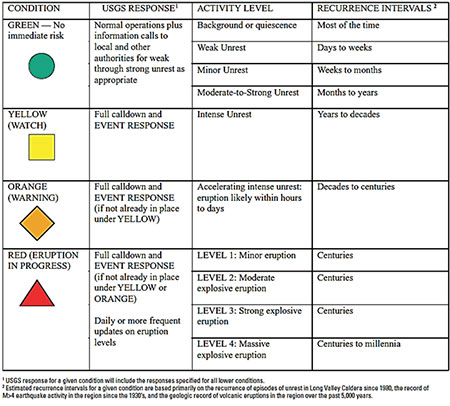
All this compiled research and new knowledge has allowed scientists to compile a sort of alarm system for volcanoes. To make it simpler to digest, I’ll be outlining the alarm system specific to the Long Valley Caldera volcano system. The table below outlines a general overview of the signs of the volcano erupting mostly based on the seismicity. The seismicity is more easily quantified and tracked to allow a proper estimation of eruption time. There are 4 levels denoted by colors, green being the normal activity for a volcano that won’t erupt very soon. Red represents an eruption is occurring currently.
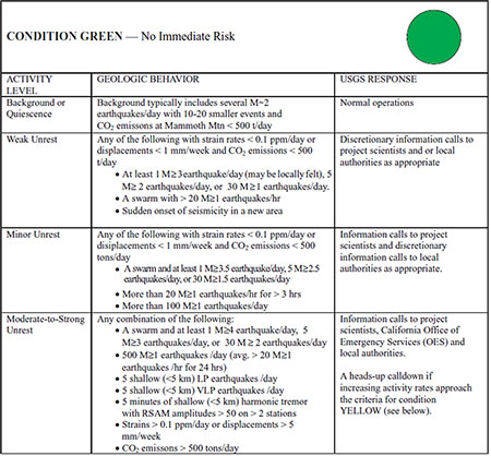
Green
Green represents a volcano that isn’t likely to go off in the next week basically. This level has 4 sub levels to describe how "rested" the volcano is. Even in the lowest level for concern it allows for several small magnitude earthquakes a day, a certain amount of CO2 emissions and a certain amount of displacement. Weak unrest is characterized by more earthquakes in number and at least one of magnitude 3. Another characteristic of the weak unrest sublevel is the abrupt seismicity in a new area. Weak unrest warrant calls to local authorities where fitting. Minor unrest can have up to one 3.5 magnitude earthquake per day and 5, 2.5 magnitude earthquakes per day and about 100 small 1 mag. earthquakes a day. The scientists working in this area are notified at this level and so are the appropriate authorities. Moderate to strong unrest calls for calls to the office of emergency services, the local authorities in the affected cities, and the scientist studying the area if they have not already been called. At this sub level there is at least one earthquake of magnitude 4 a day and a generous allowance of smaller earthquakes including shallower earthquakes. This table outlines all of this information and this is from the official volcano strategy for the Long Valley Caldera area.
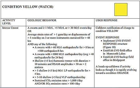
Yellow
The only sublevel in the Yellow level is called intense unrest. This level allows for up to one magnitude 5 earthquake and a few smaller ones or an allowance of up to 5 millimeters of strain a day for three days in a row and many smaller earthquakes. The response plan for this level is to put the Long Valley observatory event response in place and set up a field observatory in the Mammoth Sakes area and another in Bridgeport. A precautionary call is warranted if the activity looks like it's rapidly progressing to level orange.
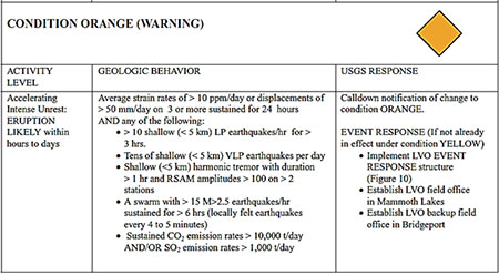
Orange
Orange level is most notably characterized by the level of deformation being around 10 ppm/day or 50 millimeters a day and below on 3 or more stations in a 24 hour period. Many small earthquakes may accompany this deformation, as well as increased CO2 emissions Reaching this level means that an eruption is likely within hours or days and necessary evacuation must be implemented at or before this point of unrest.
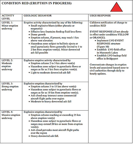
Red
Red level is broken down in sub categories dependent on the level of eruption; minor, moderate, strong, and massive. Minor eruptions may have explosive blasts of magmatic or phreatic (water) origin. Some effusive eruptions are expected and the areas nearby may be subjected to tephra and pyroclastic flows. Also the dome may bulge and grow larger at this point.in a moderate eruption the eruption column may grow up to 5km in height above the vents, pyroclastic flows and air fall debris/tephra ash will occur. In the strong eruption level expect to see large 5-15km tall columns and pyroclastic surges up to 10km out from the vents. Ash clouds will block site of any aircraft in the area and they will need to be rerouted. Ash fall will occur in the nearby areas that are downwind of the eruption. The final eruption level, Massive, will have large amounts of ash fall pyroclastic flows extending 20km out from the vents and a large eruption column at or over 25km in height above the vents. Overall the red level requires daily or hourly updates the authorities on the status of the eruption and volcano. This table outlines these levels.
Abbreviations:
- LP = long period
- LVO = Long Valley Observatory
- M = Magnitude
- RSAM = real-time seismic amplitude measurements
- t = tons
Conclusion
In conclusion, science and understandings of volcanoes and their processes have increased greatly since the times of Pompeii. Knowing the processes and the resulting products has helped us better understand how to prepare for disaster associated with volcanos. Also with the use of new technology and monitoring techniques we can predict around when a volcano will go off and put together a plan of action to avoid human fatalities. However property damage, water blockage and roadway damage may not be as avoidable.
citations
Hill, D. P. (2002). Response plan for volcano hazards in the Long Valley Caldera and Mono Craters region, California. Menlo Park, Calif.: U.S. Dept. of the Interior, U.S. Geological Survey .
Volcano Hazards. (2009, February 2). Retrieved June 4, 2014, from website
Smith, K. (2013). Environmental hazards assessing risk and reducing disaster (Revised ed.). London: Routledge.
[Return to Research Projects] [Return to Sierra Home]