Geology and Natural Heritage of the Long Valley Caldera
Volcano Tourism: Hazards and Mitigation
Madi McNew
Abstract
The Long Valley area of California, including the Long Valley Caldera, the Mono-Inyo Craters, and Mammoth Mountain, is a prime area for geotourism. Geotourism is a branch of tourism stemming from ecotourism and sustainable tourism. The volcanic features in the area and the Mammoth Mountain ski resort attract thousands of visitors each year. The various products and effects of volcanoes make hazards unavoidable. Regardless of the known hazards of living near and visiting an active volcanic site, various small towns are located precariously within and around the active zone and would be affected if an eruption occurred. Therefore, monitoring and mitigation of the volcanoes are necessary in order to protect the residents and tourists in the event of a volcanic eruption. Towns also need to provide residents and visitors with information and response plans to educate and ensure safety without detracting from the visit.
Introduction
Volcanic features, such as fault zones, craters, domes, steam vents, hot ponds, and calderas attract tourists from all over the world each year. National Parks like Yellowstone and Hawai’i Volcanoes include volcanic features as their main focus of attraction. Small mountain towns and ski resorts, like the one in Mammoth Lakes, California, are built on and around an active volcano. While the tourism brings necessary revenue to these areas, the volcanic features do present hazards that may or may not be recognized by visitors. These hazards require monitoring from government and geological agencies in order to help mitigate the effects of potential natural disasters. Mitigation tactics that are present but not prevalent or easily accessible to visitors include educational and informational packets, response plans, and hazards awareness information. This information should be made readily available to residents and visitors in order to ensure safety and promote volcano education.
TOURISM PRACTICES IN THE SIERRA NEVADA
Volcanoes as Geotourism
National Geographic’s Center for Sustainable Destinations [2010] defines "geotourism" as "tourism that sustains or enhances the geographical character of a place—its environment, culture, aesthetics, heritage, and the well-being of its residents." While geotourism is a relatively new form of tourism, it derives from ecotourism and sustainable tourism. Geotourism as a practice aims at informing the public about the Earth, conserving and preserving our natural resources and environment for future generations, and giving back to the environment through volunteer efforts or monetary donations.
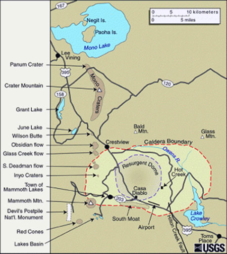
Long Valley Caldera
The Long Valley Caldera was formed approximately 760,000 years ago due to an extremely large eruption. Erosion and glaciation have transformed the boundaries and the depth of the caldera over the years [USGS Volcano Hazards Program]. The caldera runs 17 by 32 km, and a resurgent dome resides in the middle of the caldera that is about 10 km long. The resurgent dome was formed when magma underneath was put under pressure, causing the ground above the magma chamber to uplift and deform. The eruption that formed the caldera also expelled a large amount of debris and tephra in the forms of ashfall and pyroclastic flows. The debris from the eruption is known as the Bishop Tuff and can be seen as far east as Oklahoma, Kansas, and Nebraska.
This figure is a map of the Long Valley Caldera and volcanic features in the vicinity. Figure reproduced from USGS Volcano Hazards Program (exact reproduction).
Mammoth Mountain
Mammoth Mountain is located on the southwest rim of the Long Valley Caldera. While Mammoth Mountain is home to a world-class ski resort, the mountain is also an active volcano and an attraction for geologists. The mountain, which is the largest in the area, was formed around 57,000 by multiple eruption periods [USGS Volcano Hazards Program]. The location of the mountain on the rim of the caldera may be due to fissures where the magma followed the path of least resistance to the surface. Mammoth Mountain has been the site for earthquake activity in the past, and it is therefore a highly monitored area.
Mono-Inyo Craters
The Mono-Inyo Craters are located between Mono Lake and Long Valley. They were formed as early as 600 years ago. The craters were formed by phreatic explosions; when hot water was exposed to magma, the water flashed to steam, and the reaction initiated an explosion. The craters are located in a general north-south direction that indicates a dike running underneath. The dike was a path of least resistance for the magma, and the eruptions occurred at vents above the dike where the ground was faulted and especially weak [USGS Volcano Hazards Program]. Because the Mono-Inyo Craters are a rather new geological feature, geologists are closely monitoring the area because future activity is likely to resemble eruptions that created this chain.
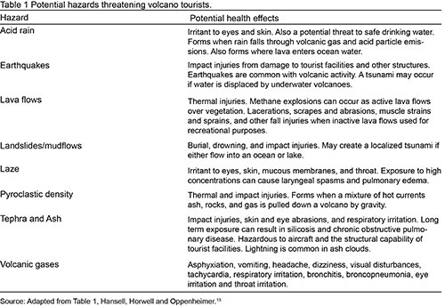
PRODUCTS OF VOLCANOES AND SPECIFIC HEALTH HAZARDS
Lava Flows
Lava flows are fundamentally associated with volcanoes. However, volcanoes can be classified as red or gray, meaning that a volcano is primarily effusive or primarily explosive. Effusive volcanoes produce lava flows. Lava flows are destructive because they bury and burn whatever is in their path. They rarely threaten human life, however, as they are typically slow. Humans tend to have enough time to evacuate with their possessions, and there have been instances when humans have even tried to stop or divert lava flows, with mixed results [McGuire, 2002]. Volcanoes in the Long Valley area are primarily felsic, and therefore are more explosive than effusive. The magma contains a high level of silica and is also very viscous, causing the magma to stick to the inside of a volcano and clog the opening [Merritts, 1998]. Therefore, Long Valley volcanoes tend to explode gray matter, making lava flows less of a concern to residents.
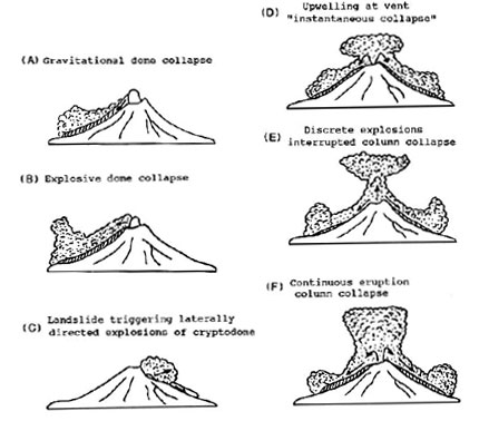
Pyroclastic Flows
Pyroclastic flows are comprised of rock material of various sizes and gases that erupt from a volcano in an event similar to a lava flow or mudslide. Pyroclastic flows typically occur in conjunction with an ashfall [USGS Volcano Hazards Program]. Flows are fast and dangerous, destroying and burying all in its path. Flows are caused by several different forms of explosions and collapses (see figure below). These flows are a hazard to the Long Valley area because the volcanoes are primarily gray, eruptive volcanoes. The Mono County Multi-Jurisdictional Local Hazard Mitigation Plan [2006] includes two scenarios that describe what actions will be taken if pyroclastic flows or surges occur. While the plan provides for the worst-case scenario, in which multiple volcanoes erupt simultaneously, even one pyroclastic flow would cause extreme damage. Although an evacuation would be possible, the areas closest to the eruption site would be affected most, causing damage to all buildings nearby. The plan also mentions how pyroclastic flows occurring in the winter months would also cause snowmelt and could possibly cause consequential mudslides.
Mechanisms for generating pyroclastic flows (modified from Cas andWright, 1987). Mechanisms B and C represent formation of laterally directed blasts; catastrophic blasts would have an origin as in C. D, E, and F represent three of many origins based on collapse of eruption columns.
Figure reproduced from Scott [1995] (exact reproduction).
Ashfall
Ashfall is one of the most detrimental products of volcanoes as it can negatively affect human health, particularly the respiratory system. While the short-term affects, like coughing, wheezing, and discomfort while breathing, aren’t considered to cause long-term harm, people are still advised to avoid breathing ash. People who have preexisting respiratory conditions will be affected to a greater magnitude [USGS Volcano Hazards Program]. Ashfall can include tephra and lapilli of larger sizes that can damage structures. If debris is not cleared from buildings, the weight of the ash can cause roofs to collapse. Ash can also cause damage to airplanes in flight and communications and power lines. Other long-term effects include the killing of crops and contamination of water sources [McGuire 2002]. While some effects of ash cannot be prevented, avoidance of ash and the timely clearing of ash can greatly reduce damages.
Volatiles
Volcanic gases such as sulfur dioxide, carbon monoxide, and carbon dioxide are prevalent around volcanoes and fumaroles. Sulfur dioxide produces a noticeable smell, and the short-term effects of exposure to the gas will not cause any severe problems. However, long-term exposure to the gas can cause eye, skin, and lung irritation and difficulty breathing [Heggie, 2009]. Carbon monoxide and dioxide are both odorless and can be deadly in high concentrations. It is denser than air, so it tends to accumulate in fumaroles or low-lying topographic features. Large quantities of carbon dioxide near Horseshoe Lake sunk into the soil and killed trees in the area, as well as a couple skiers who became trapped in a snow depression [USGS Volcano Fact Sheet].
Secondary Effects
Mudslides can be caused when volcanic explosions melt snow, when rain occurs simultaneously with an eruption, or when lakes contained in craters erupt [USGS Volcano Hazards Program]. Collapse of volcanoes can happen without warning due to the loosely compacted makeup of most volcanoes paired with steep slopes and weaknesses within the structure of the volcano [Scott, 1995]. Earthquakes and volcanic collapse into the ocean can also trigger tsunamis on nearby or foreign shores. Hazards caused after initial volcanic activity can be just as destructive and dangerous as the volcanic activity itself, as many secondary effects come without warning.
Climate Change
Volcanic eruptions have the capability to alter the climate on a large scale. Gases exhausted from volcanoes can travel long distances and block the sun in the form of gas clouds, lowering the temperature in some places and raising it in others [McGuire, 2002]. However, according to the USGS Volcano Hazards Program, carbon dioxide in the atmosphere is not capable of causing global warming, and humans produce more CO2 emissions than volcanoes [2012]. There are no known ways to mitigate volcanic effects on the climate, but it is apparent that volcanoes contribute to global cooling rather than global warming.
Figure reproduced from Heggie [2009] (exact reproduction).
MITIGATION OF VOLCANIC PRODUCTS AND EVACUATION PLANS
Hazard Scare of 1980s
In the early 1980s, geologists warned the inhabitants of Mammoth Lakes of impending hazards multiple times after a series of large earthquakes. The local business owners grew tired of the warnings scaring off customers, and geologists were torn between being too sensitive to volcanic activity and being safe. The warnings led the economy and the housing rates of the tourist town to plummet 40% in just a day [Blakeslee, 1990]. The scare allowed a new system of warnings to be put into place, in which the public would not be alerted until the fourth level. While the changes helped Mammoth Lakes return to normal, it is still debated as to when the public has a right to know the status of the active volcano they are living next to.
Mammoth Scenic Loop Escape Route
In conjunction with the increased earthquakes and warnings in 1983, an escape route was built connecting Mammoth Mountain to Highway 395 [Colasurdo, 2000]. Previously, only one road connected the two. However, after the scare wore off and the economy returned to normal, the route was renamed the "Mammoth Scenic Loop" to further encourage tourists. While the route remains an extra means of escape during an emergency, labeling it as a tourist attraction greatly detracts from the education of hazards present in the area.
Mono County Multi-Jurisdictional Local Hazard Mitigation Plan (LHMP)
The Mono County Mitigation Plan is a very detailed plan that provides for mitigation of various natural hazards. When describing volcanic activity, the document provides research-backed information and the geological history of the area. The plan mentions the unrest of the 1980s but still puts the probability of a large explosion occurring at less than 1% per year. However, the plan does say that if the volcanic activity calls for an orange condition, then the probability greatly increases [Mono County Multi-Jurisdictional LHMP, 2006]. While the document basically says that probability is low in our lifetime, it covers itself by saying that future eruptions cannot be predicted and that an eruption could occur at any time or never. While the document prepares for the worst scenarios and plans out losses and destruction, the document is trying to convince people that nothing will ever happen. Volcanic activity in Mono County is high, and the document would be better suited to make plans for smaller hazards and be prepared to teach tourists how to protect themselves in small and large-scale volcanic events.
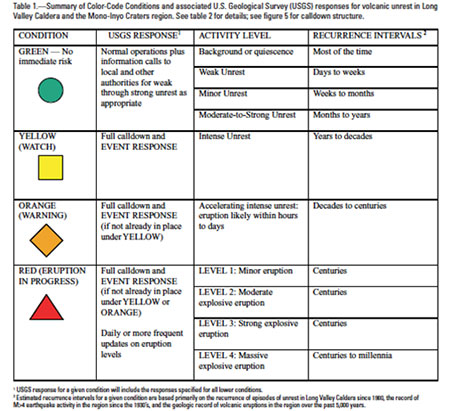
Response Plan for Volcano Hazards in Long Valley Caldera and Mono Craters Region
The Response Plan for Long Valley includes the new Color-Code Conditions for volcanic activity, although the conditions were formed and adopted in conjunction with Mono County and other agencies in 1997 [Hill, 2002]. While the document gives background history on the geological processes of the area, the majority of the document discusses the color conditions and what actions will be taken under each color. The document also assigns public officials and geologists roles in the event of a catastrophe. This response plan seems more informative and user-friendly than the Mono County LHMP because it is written in simpler terms, includes detailed descriptions of each color condition, and provides necessary background information.
Figure reproduced from Hill [2002] (exact reproduction).
VOLCANO MONITORING
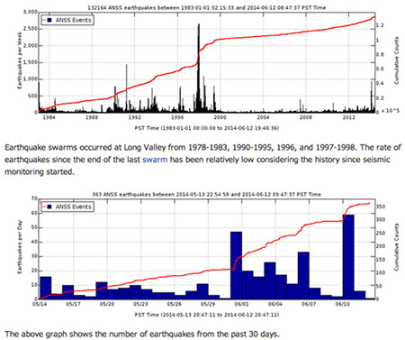
Seismicity
The United States Geological Survey conducts seismicity monitoring with 61 seismometers in the Long Valley area [USGS Volcano Hazards Program]. The seismometers record when the earth moves as magma moves through it. Periods of higher unrest, in which a large number of earthquakes occur each day, may be signs that the magma is getting closer to the surface and that volcanic activity may be approaching. The USGS website shows the number of earthquakes per day for the last 30 days compared to a graph with number of earthquakes per week. Spikes in the past included a far greater number of earthquakes per day than any spikes occurring within the last 10 years.
Figure reproduced from USGS Volcano Hazards Program [2012] (exact reproduction).
Deformation
Deformation of a volcano or landmass occurs when lava underground moves closer to the surface, forcing the ground to expand or deform upward and outward. This deformation can be monitored by GPS and tiltmeters. The USGS has 46 GPS receivers and 9 tiltmeters in the Long Valley area that measure deformation [USGS Volcano Hazards Program]. The GPS devices use pinpoint locations to measure change in distance over time. The tiltmeters work like a level to measure change in angle over time. New satellite images are also being gathered that will allow geologists to detect deformation of remote or inaccessible volcanoes from a lab, providing them with more information and the ability to warn otherwise unsuspecting residents [University of Bristol, 2014]. While deformation can occur long before eruptions, monitoring deformation still gives geologists a good idea of how active the volcano is and can help decide when to warn the public about possible hazards.
Eruption Rates and Hazard Maps
Historical references can give geologists timelines of volcanic activity. Past eruption rates can be studied in order for geologists to derive patterns and try to predict future outcomes based on those timelines [Chester, 2008]. Volcanologists recently created a program that will determine how far pyroclastic flows will travel based on the topography of the area. This kind of hazard mapping will determine different levels of risk for each area and will allow officials to notify residents quickly if they are in danger [Penn State, 2009]. Hazard maps are another way for officials to plan for realistic hazards and make the information available to residents before the event occurs.
THE FUTURE OF LONG VALLEY AREA
Likeliness of Future Eruptions
While the USGS says that the probability of a large volcanic eruption in Long Valley is less than 1% in any given year, they also recognize the fact that volcanoes are unpredictable and that an eruption could occur without warning [USGS Fact Sheet, 1998]. A small, phreatic eruption like those that formed the Mono-Inyo Craters would be most likely. Because those structures are so recent and in such a linear pattern, it would make sense that another small feature would occur in the same fashion. Any type of eruption will have impacts on the environment, but all impacts vary based on size and style of eruption. Another large eruption like that which deposited the Bishop Tuff would devastate the area, be very hard to avoid, and could have secondary effects worldwide.
Plans Put into Action – What Will Work?
Because Long Valley and Mammoth Mountain are tourist attractions, the towns involved must be aware of protecting both residents and tourists. While residents can be expected to know the response plans and color conditions, visitors will not seek out such information. An evacuation of Mammoth Mountain or Long Valley would have to be swiftly executed and organized in order to work correctly. However, in an emergency situation, officials must act as though no one knows the plan. No form of planning will ever be able to eradicate chaos during an emergency or to ensure that no fatalities occur. Regardless, response plans are necessary and condensed versions should be made readily available to visitors. At the very least, visitors should be made aware of daily volcanic hazards and should be aware of the color conditions should the area enter a color level. Another problem to be addressed is the fact that most posted hazards signs are only in one or two languages, making the signs worthless to many visitors. Japan is a leading example in volcano hazard safety, as they list warnings in up to four languages and with picture symbols [Erfurt-Cooper, 2011]. Many visitors of different ethnicities travel to see the volcanic sites in California, and the majority of the posted information, risks, and warnings are only printed in English, making all warnings irrelevant. Posting signs in multiple languages would increase education for tourists and would make the trip safer and more enjoyable in general.
Conclusion
Thousands of people live in the vicinity of active volcanoes, and thousands more visit volcanic zones each year for recreation and geotourism. Volcanic sites harbor numerous small hazards and the potential for catastrophic hazards that visitors to the area may not be aware of. Towns that are in the midst of these hazards must take steps to provide information to residents and visitors in order to educate them and ensure a safety without detracting value from the visit. Volcano monitoring is an important way for geologists to predict when volcanoes will advance from being in a state of unrest to being active. It is possible that an eruption will occur of any size in the near future, which is why residents and tourists need to know the hazards associated with the area and be prepared for anything.
References Cited
About Geotourism. (n.d.). Center for Sustainable Destinations, Geotourism, Places, Tips, Articles. Retrieved June 11, 2014 website
Blakeslee, S. (1990, September 11). Wrong Once, Experts Keep Quiet on Volcanic Activity in California. New York Times.
Chester, R. (2008). Furnace of Creation, Cradle of Destruction: A Journey to the Birthplace of Earthquakes, Volcanoes, and Tsunamis. New York: AMACOM.
Colasurdo, C. (Fall 2000). Mammoth’s Perilous Magma. California Wild, V53.4.
Erfurt-Cooper, P. (2011). Geotourism in Volcanic and Geothermal Environments: Playing with Fire?. Geoheritage, 3, 187-193.
Heggie, T. W. (2009). Geotourism and volcanoes: health hazards facing tourists at volcanic and geothermal destinations. Travel Medicine and Infectious Disease, 7(5), 257-261.
Hill, D., et al. (2002). Response Plan for Volcano Hazards in the Long Valley Caldera and Mono Craters Region, California. Menlo Park, California: U.S. Geological Survey.
McGuire, B. (2002). Raging Planet: Earthquakes, Volcanoes, and the Tectonic Threat to Life on Earth. Hauppauge, NY: Barron’s.
Merritts, D., DeWet, A., and Menking, K. (1998). Environmental Geology: An Earth System Science Approach. New York: W.H. Freeman.
Mono County Multi-Jurisdictional Local Hazard Mitigation Plan. (2006). Retrieved June 6, 2014, from website
Penn State. (2009, January 26). Off the Shelf Maps Help Mitigate Volcanic Hazards. ScienceDaily. Retrieved June 10, 2014 from website
Scott, W. E. (1995). Volcanic and Related Hazards. Vancouver, Washington: U.S. Geological Survey.
University of Bristol. (2014, April 3). Satellite view of volcanoes finds the link between ground deformation and eruption. ScienceDaily. Retrieved June 10, 2014 from website
USGS Volcano Fact Sheet. (1998). Future Eruptions in California’s Long Valley Area—What’s Likely? U.S. Geological Survey.
USGS Volcano Fact Sheet. (2000). Invisible CO2 Gas Killing Trees at Mammoth Mountain, California. U.S. Geological Survey.
USGS Volcano Hazards Program. (n.d.). Volcano Hazards Program. Retrieved June 6, 2014, from website
[Return to Research Projects] [Return to Sierra Home]