Geology and Natural Heritage of the Long Valley Caldera
Glacial History and Processes of the Sierra Nevada
Mitchell Latta
Abstract
Glaciation can change a lot of things and it has done so around the Sierra Nevada. There are features and landforms that would not exist if it was not shaped by glacial activity. Yosemite is an example of a place that has been altered and shaped by glacial activity. The rock has been cut and smoothed by the ice slowly moving through. You can see mountains where ice has cut into pre-existing fractures to form multiple jagged mountain tops and others where a mountain has no fractures to intrude and is just smoothed to an even granite dome. The glacial activity not only in Yosemite but the entire Sierra Nevada has evidence of glacial activity over time.
Glaciers
A glacier is a very interesting and powerful thing. It is an extremely large body of dense ice that is always moving under the force of its own weight. They are formed over long periods of time, sometimes centuries, when snow and ice can accumulation surpasses the melting of the ice. Overtime glaciers move and slowly they begin to deform and break under the stress of its own weight. This stress causes fracturing which leads to crevasses which are deep cracks in the ice sheet. These crevasses can be used to distinguish a glacier from a solitary body of ice. Mostly all of the glacial ice left on earth is contained in expansive ice sheets in the polar regions, but you can find smaller glacial activity in mountain ranges in every continent but Australia. Glacial ice is the largest reservoir of freshwater on the planet. Glaciers contain freshwater as ice in alpine environments and during warmer seasons that ice can melt and be used by the public for consumption or other things. The volume and weight of a glacier make it easy for it to cut and abrade rock very easily. It can break rocks along pre-existing fractures or just cut them down by the amount of stress it can apply. Because it can deform rock so easily, it can also leave behind some interesting features and landforms for us to observe.
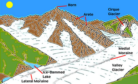
Glacial Landforms
Glaciers leave a lot of evidence behind in different ways. There are a variety of different types of landforms and features that a glacier can leave as it cuts through the topography (some shown in the picture above). There are landforms made by erosional and depositional processes. One example of an erosional glacial landform is a cirque which is a circular impression made at a mountain peak from and show where a mountain glacier originated from. U-shaped valleys are created when a glacier cuts through rock and forms a wide open valley in the U-shape. Another erosional landform is an arète. Arètes are spiky lands that are higher than a glacier and have been left behind after a glacier has passed through. An example of a depositional landform is a moraine which is an accumulation of glacial debris. A Medial moraine is a moraine that forms in the middle of two converging glaciers. A Lateral moraines form on the sides of a moving glacier, and a terminal moraine forms at the end of a glacier. Another depositional is an outwash fan which is a fan of glacial debris that gets dumped at the end of a glacier. Glaciers can also be responsible for the creation of different lakes and ponds. A kettle lake forms when a block of ice breaks off of a glacier and forms a depression which then fills with water. A glacial lake is a lake that forms between the last terminal moraine and the front of a glacier. Striations are also great evidence for identifying glacial activity. Striations are lines that have been cut into rock by glacial movement.
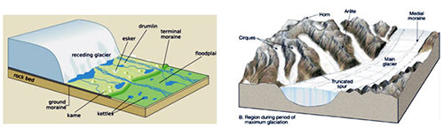
Continental vs. Alpine Glaciation
Continental glaciation (above left picture) and alpine glaciation (above right picture) are a little different in the way they form and what types of landforms they produce. Continental Glaciers are expansive masses of ice which are considerably larger than the alpine glaciers. These continental glaciers are sometimes referred to as ice sheets and can be extremely thick. Smaller continental glaciers are also referred to as ice fields. Continental glaciers can form moraines, drumlins, kettle lakes, and create long flat valleys as they cut across the surface. Alpine glaciers begin up in a mountain where the snow and ice accumulates in a bowl shaped depression or a cirque. The ice then flows out of the cirque and down the mountain into a valley where it can run into or join other alpine glaciers. Alpine glaciation can form moraines, arêtes, cirques, u–shaped valleys, and other smaller features. These glaciers are similar in processes and form similar landforms but they also have their differences like size and how they are formed.
History of Glaciology
Glaciation is the study of the natural formation of ice on the Earth and or other celestial bodies. This study is mainly focused on the formation of glaciers and large polar ice sheets. Glaciology is considered as a geological profession, as well as a meteorological and an astronomical profession which means that glaciologists normally require more training and education from a variety of different scientific fields. Glaciologists can work with the ice for a few different reasons. Some are interested in the geologic history that goes along with glaciation and others prefer to use the ice to determine the effects of global warming on the earth or climate change. However, one of the principal goals of glaciologists is to determine what the climate was like on the planet eons ago. Ice, like layers of rock strata, can tell us something about the natural history of the Earth. Through different core samples of the ice, scientists can figure out what the composition of the Earth’s atmosphere were at the time that rock was formed. This, especially when cross-checked with the geologic record can show us what different species must have for optimal survival. Glaciology can also be studied to explain why we see certain landforms even when there are no current glaciers or ice sheets to be found. For example there are no glaciers in the present-day Midwestern United States but, the rolling hills found in this area were most likely created by a glacially-related mechanism. Another interesting thing about this field is what it can help us figure out on a galactic scale. If we can understand glaciation on other planetary bodies, we may be able to find signs of extraterrestrial life on other planets that exhibit the appropriate environment. To sum it up glaciology is a very interesting field with multiple helpful applications. Most glaciologists work with different research facilities or universities but some can work in the private industries looking for oil or certain minerals.
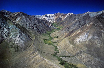
The Sierra Nevada
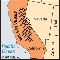
The Sierra Nevada area (above picture) is located along the state borders of East-Central California and Western Nevada. We visited many sites along this area and we saw a lot of different geologic features. However, a lot of the places we went, especially the alpine environments, had evidence of glacial activity. It is clear that there were a lot of things going on glacially in that area. This area is right along the end of the basin and range which is a series of mountain ranges and valleys running east to west along California and Nevada.
Glaciation and Geomorphology of the Sierra Nevada Area
Intro to Glaciation of the Sierra Nevada
The Sierra Nevada is definitely a very interesting place when you are talking about geology and glaciology. There is so that went on in that area tectonically, volcanically, and glaciological. It is truly an amazing place to study as far as geology goes because it seems to cover something in every single branch of geology and the area is just so beautiful all-around. The glaciological aspect is especially interesting because there is just evidence of glacial activity all over the area.
Alpine Glaciation of the Sierra Nevada Mountain Range
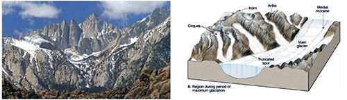
The Sierra Nevada Mountain Range (above left picture) is a perfect place to study alpine glaciation. The picture shows a few of the features from the diagram to the right such as the horns, arêtes, and a U-shaped valley. This is showing classic examples of alpine glaciation where an accumulation of ice occurs at the peak of a mountain causing a cirque. Eventually as the ice accumulates and gets heavier it slowly starts to drift down the mountain cutting away at the rock to form these arêtes, and U-shaped valleys as it flows down into the valley where it can be absorbed into other free moving glaciers. When it finally gets to the valley it will most likely dump a lot of the heavier stuff into moraines. These moraines can be huge and are found all around the base of the Sierra Nevada mountain range. The entire area around the Sierra Nevada is loaded with huge glacial erratics. These are giant rocks and boulders that have been picked up by a glacier and deposited in another new environment. Without glacial activity these erratics would have never ended up all over the area. The picture below shows a U-shaped valley which is outlined by two lateral moraines that flow toward the basin.
Glacial History of the Sierra Nevada Area
Like any story, the story of the Sierra Nevada is very complex and long but so many people have studied this area for so long that we are starting to piece the book together. Once the tectonic movement and mountain building processes had created the mountains in that area, it became a big target for glacial processes to occur. These glaciers came in and reshaped the landscape. We do know that the mountains had to pre-date the glaciers because the mountains would have had to occur first if they were affected by glacial activity. This has to be true because if the mountains were not there when glaciation occurred we wouldn’t see any of the evidence of alpine glaciation. We know by dating methods that there were periods of glaciation in the Sierra Nevada during the Pleistocene epoch which lasted from 2,588,000 to 11,700 years ago. The Pleistocene marks the world’s most recent period of repeated glaciations, so this is not a huge surprise to most geologists. During the Pleistocene an estimated 30% of the Earth’s surface was covered by ice at maximum glacial extent. The average annual temperature around the edge of the ice was 21°F. Each of these glaciers during this time period could be extremely thick, from 4,900-9,800ft thick. Snow would accumulate at the top of the Sierras and be compacted into ice. As the ice gets accumulated the glacier begins to flow under the force of its own weight, and creates all the features that are shown in the area of the Sierras. This classic example of alpine glaciation is the dominant force that shaped the Sierras. When you think of all the cutting and sculpting glaciation can do you can realize that it plays a huge role in how our topography looks today, not only in this area but all over the planet. These glaciers determined what the Sierra Nevada area looks like and, for the most part, it has remained the way they left it after they receded away.
Glaciation of Yosemite National park
Intro to the Glaciation of Yosemite National Park
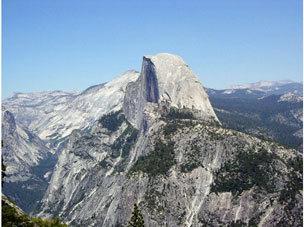
Yosemite National Park is a great place to study glaciation. The picture above (half-dome in Yosemite National Park) is one of many great examples of glacially sculpted landforms that reside in the park. It is a fantastic place to see some truly amazing evidence of glacial processes and the impact a glacier can have on a place.
Yosemite Glacial History
Yosemite Valley has been shaped and carved by several glacial events, one which covered nearly all of half-dome. The rock that was carved by the ice formed around the cretaceous period, about 100 million years ago. Eventually glaciers began to intrude the area and changed the topography drastically. Yosemite Valley has been referred to as a "classic" glacial valley and was profoundly influenced by these moving ice sheets. During one event in the Merced River canyon, a glacier filled the valley to its rim which created the general broad shape of the valley and cut out a deep bedrock basin, which in its eastern part, lies over 1,000ft below the present floor of the valley. François Matthes named this glacial episode El Portal in his huge Yosemite study. This name was given because François originally believed that the glacier flowed down the Merced canyon towards the community of El Portal. Today we know that the El Portal episode is similar to the Sherwin glaciation which was defined from studies along the east side of the Sierra Nevada and which name is now used to describe this episode. The Sherwin is the most extensive, and longest-lived, known glaciation that is documented in the Sierra Nevada. This Sherwin glaciation may have lasted 300 thousand years and ended about 1,000,000 years ago. Glaciations that occurred after the in the Sierra Nevada were of smaller areal extent and did not last as long as the Sherwin. The most documented events are the Tioga and Tahoe events, which most likely spiked at about 130,000 and 20,000 years ago, respectively. Together they’re equivalent to Matthes’ "Wisconsin" glacial stage, which he didn’t subdivide. The last known glacier in Yosemite Valley which was around the same age as the Tioga event only advanced as far as Bridal veil Meadow. The advancing forward flow of the glacier was balanced by the melting of ice at its front, or terminus. A "terminal" moraine, a low ridge crossing the valley, was built with loose transported rock debris carried by the glacier and deposited at its end. The extent of the younger Tahoe-age glacier within the valley is not clear, but evidence in other places around the Sierra Nevada, suggests that it most likely would have been a little bit lengthier than the Tioga glacier. Nonetheless, since the first excavation of Yosemite Valley by a Sherwin-age glacier, no earlier glacier has packed the valley to the rim, a conclusion that has significant impacts on the topography. These events and others have helped to shape Yosemite National Park into what it is today.
Features of Yosemite National Park
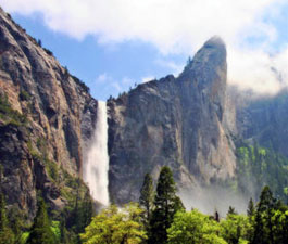
Hanging Valley Waterfalls
These glaciers have literally cut the park into what it is today. Bridal Veil Falls (shown in the picture above) is formed as a result of a hanging valley. A hanging valley is a river valley at a greater relief then the main passage which it flows into. The main glacier cuts away at a deep U-shaped valley with sides that are almost vertical while the river valley, with a much smaller volume of ice, makes a shallower U-shaped valley. Because the surfaces of the glaciers were generally at the same level of elevation, the shallower valley seems to be "hanging" overhead the main valley.
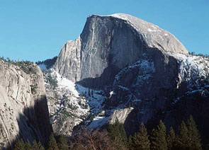
Half Dome
Half Dome is a very interesting and extremely popular example of glaciations ability to change the landscape. Half Dome is a fairly rounded granite dome in Yosemite National Park and possibly the most well-known feature in the park. The dome seems to be cut in half, hence the name. Back during the Sherwin Glacier event most of half dome was covered by ice. This is responsible for why the dome was cut in half. The glacier got into joints and preexisting fractures and expanded until the rock broke off and formed what you see today (outside of deformation erosion over time). This is yet another powerful example of how glaciers can re-shape the landscape.
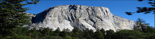
El Capitan
El Capitan (above photograph) is another example of glaciation in Yosemite. El Capitan is a granite monolith about 3,000ft from base to summit. This monolith has survived several periods of glaciation, but the Sherwin glaciation was the longest episode it encountered. The impressive thing about the formation is the overall size of the outcrop. This massive monolith has been kept in one piece because for the most part there were no preexisting fractures for the glaciers to cut through. Therefore, the monolith has remained intact, minus erosion over time, and will continue to be a popular tourist and climbing destination for the public.
Overview
The Sierra Nevada is a very diverse and special place, geologically speaking. The amount of processes that went into the development of that area is mind-boggling. There is overwhelming evidence that glaciation played a huge role in sculpting out this area. It also proves just how powerful glaciers are, and how they can so easily manipulate the landscape under the weight of their ice. Glaciation can make a huge impact on our environments and we can learn a lot about studying them and what they have left behind for us to find. In the Sierra the products of glaciation are almost textbook examples of what glaciers leave behind and how they impact our landscape.
References
Clark et al. "Mountain Glaciations of the Sierra Nevada." Quaternary Geology of the United States. Field Guide volume, Desert Research Center Institute, Reno, NV. Pg.287-311. PDF.
Hill, Mary. "Geology of the Sierra Nevada." California Natural History Guides. University of California Press. May 15th 2006. PDF
Huber, N. King. "The Geologic Story of Yosemite Valley." United States Geological Survey. U.S. Geological Survey Bulletin 1595 pg. 64. Web.
Gillespie, Alan R., Zehfuss, Paul H., "Glaciations of the Sierra Nevada, California, USA." Quaternary Research Center. U of Washington. 2004. PDF.
Phillips et al. "Chronology for Fluctuations in Late Pleistocene Sierra Nevada Glaciers and Lakes." Science Vol. 274. (1996) pg. 749-751. PDF.
Resendes, Mary Ann. "Geology of the Sierra Nevada." Central Sierra Historical Society. Central Sierra Historical Society, Shaver Lake CA, 2012. Web.
[Return to Research Projects] [Return to Sierra Home]