Geology and Natural Heritage of the Long Valley Caldera
The Unique Ecosystem of Mono Lake
Aidan Geissler
Abstract
This research paper examines the geology and ecology of the Mono Basin. This paper explains how the unique geological, volcanic, and hydrological setting of the Mono Basin was formed, and how this geology engenders the unique ecosystem of Mono Lake. Upon observation, both anthropogenic and drought-induced decreases in lake levels have clearly threatened the lake’s ecosystem. It is predicted that continued lowering of lake levels would quickly destroy the life in Mono Lake. And as this lake is vital to the migration and life of millions of birds, the destruction of this productive ecosystem would certainly be significant and devastating. Thus, the unique, productive, and important ecosystem of Mono Lake needs to be protected.
Introduction
Mono Lake is located in the Mono Basin of Mono County, California. The unique historical geological setting of tectonics and volcanism shaped the basin to be completely enclosed by mountains and hills, creating the internally draining watershed known as Mono Basin. In this basin is Mono Lake, one of the most alkaline, most saline, and oldest lakes in the US (Hill). The lake is at least 760,000 years old, about 21 km long, about 13 km wide, and has a current average depth of about 17 meters (Hill and Quick Facts). This peculiar lake has unusually high levels other minerals such as carbonates, chlorides, sulfates, and more (Chemistry). This unusual water chemistry grants the lake a unique ecosystem. While few species can survive in such extremely saline, alkaline water conditions, those that can survive exist in flourishing abundance. Therefore, the lake is teeming with brine shrimp and alkali flies, providing birds with an abundance of food (Hill). Thus the lake has come to play a critical role in regional bird migration. The lake has also suffered from anthropogenic water diversion, lowering lake levels, increasing salinity, and threatening the entire ecosystem. A significant environmental debate ensued, which remains one of the most important environmental disputes in the history of the US (Young). All things considered, Mono Basin is a fascinating blend of geology and ecology that constitutes a unique and valuable site of scientific study.
GEOGRAPHY AND GEOLOGY
Overall Geological and Geographical Setting
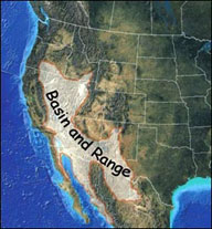
Basin and Range Province: Mono Lake is located in an extensive series of roughly north-south oriented mountain ranges with basins in between oriented in the same direction. This region is known as the Basin and Range Province. This province spans from the Sierra Nevada Range in California eastward into the entirety of Nevada and parts of Oregon, Idaho, Utah, Arizona, New Mexico, Texas, and Mexico (Introduction to the Basin and Range).
FIGURE 1: Map of Basin and Range Province (Introduction to the Basin and Range)
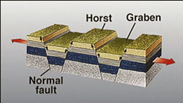
The tectonic setting is largely responsible this particular physiographic region. The lateral motion of the Pacific Plate relative to the North American plate caused the western region of North American to be stretched out. The tensional stress of this crustal stretching caused a series of normal faults to form. These faults split the region into blocks. A pattern of uplifted blocks (horsts) adjacent to down dropped blocks (grabens) were formed to accommodate the tensional stress. The horsts and grabens became the ranges and basins of the Basin and Range Province, and one particular graben formed the Mono Basin (Introduction to the Basin and Range).
FIGURE 2: Diagram of normal faulting with horsts and grabens (Introduction to the Basin and Range)
Volcanic Setting: Mono Basin resides in a region rich with volcanic history. One of the most characteristic features of the region is the Long Valley Caldera, which is a large depression created about 760,000 years ago in the aftermath of the enormous Long Valley volcanic eruption. This eruption also created the volcanic tableland, a large area of volcanic deposits known as Bishop Tuff. Volcanism also played a major role in shaping and the Bodie Hills to the north of Mono Basin and the Sierra Nevada range to the west (to be explained in more depth in the following section) (Hill). More recently than hills, mountains, and calderas, volcanism has formed volcanic domes and craters in the region. This chain of craters and domes is known as the Mono-Inyo Craters. It is located almost exclusively in Mono Basin, between the Long Valley Caldera and Mono Lake. More than 50,000 years ago eruptions that formed these craters and domes began, and the most recent eruptions were only about 300 years ago (Mono-Inyo Chain). The craters are the result of a combination of episodes of volcanic eruptions and/or phreatic explosions. Crater-forming volcanic eruptions are violent emissions of lava while phreatic explosions occur when rising magma transfers its heat to underground water, which then expands, causing an explosion that forms a crater. In addition to craters, the Mono-Inyo Crater Chain has a number of lava domes, which are mounds of igneous rock formed by the extrusion of lava with high viscosity and low gas content (Bursik).
Geological Boundaries of Mono Basin
Sierra Nevada Range: The Sierra Nevada Range forms the western boundary of Mono Basin. These mountains formed as the Farallon Plate underwent subduction beneath the North American Plate. The material melted as it approached the Earth’s hot interior, then being hotter and less dense than the surrounding material it rose towards the surface. These plutons of rising magma solidified to form the granitic Sierra Nevada batholith. The batholith underwent uplifting, primarily on the eastern edge of the Sierra Nevada where the crustal stretching and tensional forces caused uplifting and down dropping of crustal fragments to form the Basin and Range Province (Hill).
Cowtrack Mountain: The Cowtrack Mountain is part of the Basin and Range Province and it constitutes the eastern border of the Mono Basin. The peak of this mountain sits at 2698 meters above sea level, which is approximately 750 meters higher than the surface of Mono Lake (Cowtrack Mountain).
Bodie Hills: The northern boundary of the Mono Basin is formed by the Bodie Hills. The Bodie Hills were formed by many years of volcanic activity, including silicic, dacite, and rhyolite domes along with stratovolcanic eruptions (John). Ridge of the Long Valley Caldera: The Northern Ridge of the Long Valley Caldera creates the southern border to the Mono Basin. This Caldera formed approximately 760,000 years about in the Bishop Eruption. After this enormous volcanic eruption, the magma chamber was emptied, so there was no material to support the weight of the material above it. Therefore, the material above the empty magma chamber collapsed, forming what is now known as the Long Valley Caldera (Hill).
Geological Features of Mono Basin
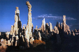
Tufa Towers: One of the most striking, unique features of Mono Lake are the tufa towers.
FIGURE 3: The Tufa Towers at Mono Lake (Rieger)
Mono Lake is the only place in the world where these particular tufa structures are visible (Hill). These towers are composed of calcium carbonate, which is the same chemical composition that constitutes limestone (Rieger). The tufa forms underwater and has been exposed and become visible due to the lowering levels of the lake water (Young). When freshwater springs in the alkaline lake emit calcium-containing water, the calcium reacts with the accumulated carbonate in the lake to precipitate into the mineral thinolite, an unusual form of calcium carbonate (Rieger and Hill). Over time the tufa forms underwater in a column around the opening of upwelling calcium water, thus the tufa towers indicate the location of current or previous underwater springs (Rieger).
Volcanic Islands: Mono Lake has 2 volcanic islands, both of which are volcanic cinder cones (Mono Lake). The larger of the two is Paoha Island, which was formed in the mid 1600s. Paoha Island has a white surface, which is composed of lake-bottom sediments that have since been uplifted due to rising magma (Hill). The island has visible cinder cones, lava flows, hot springs, and active steam vents (Mono Lake and Hill). The smaller island is Negit Island. This island is black and was formed from a series of volcanic eruptions ranging from 1,700 to 300 years ago (Hill).
Old Lake Shores: From 1900 to 1940 the Mono Lake water level was fluctuating between 6,417 to 6,427 feet above sea level. Then Los Angeles began diverting water in 1940, causing the levels to steadily decline, eventually reaching a historic low of 6,372 in 1982 (Mono Lake Level). This exposed almost 15,000 acres of lakebed (Scoonover). These highly alkaline exposures were picked up by regular Mono Basin winds causing hazardous dust storms (Young). These exposed old shorelines are visible as concentric rings around the lake. Geologically speaking, these rings are known as strandlines. The highest strandline of Mono Basin is visible at 7,180 feet above sea level. This indicates that the lake’s water levels were once about 800 feet higher than they are today (Long Valley Caldera…).
HYDROLOGY
Inputs
Streams: 5 freshwater streams provide water to Mono Lake. The water source of the streams is the melting of the winter’s snowpack in the high Sierra Nevada. The input streams are Rush, Parker, Walker, Lee Vining, and Mill Creeks (Mono Basin Creek Profiles).
Precipitation: Another water source for Mono Lake is precipitation. The average annual precipitation at Mono Lake is a mere 35 centimeters (Mono Lake). The reason Mono Lake has such a low rainfall is due to the rain shadow effect of the Sierra Nevada Range. As the eastward moving winds rise up the Sierra Nevadas, the air expands, cools, and is less capable of retaining moisture. Therefore, along the western Sierra Nevada the majority of the moisture in the air is deposited as precipitation. After crossing the Sierra Nevada Range and continuing eastward, there remains little moisture in the air, thus accounting for the low rainfall at Mono Lake (Rain Shadow). The influence of the rain shadow effect at Mono Lake is evident as the Sierra Crest receives an average annual precipitation of 45 inches while the eastern shore of Mono Lake receives only about 5 inches (Quick Facts). Additionally, an interesting phenomenon that occurs at Mono Lake is virga. Virga is when rain falls from a cloud but evaporates before reaching the ground (Virga). The dry, hot, arid climate at Mono Lake can allow this spectacle to take place.
Groundwater: Mono Lake has a number of underground springs providing freshwater to the lake. These springs are sourced by underground aquifers, which are sourced by underground runoff that ultimately came from precipitation on or along the mountains. Gravity drives the groundwater runoff downwards where it eventually collects in a water-saturated aquifer; here some of the water rises upwards to relieve the immense gravitational pressure. Sometimes underground magma transfers heat to the water, causing it to expand, rise, and eventually reach the surface to form a thermal spring (Winkler).
Outputs
Evaporation: With no outflow of water by any stream or river, evaporation is the primary and arguably the only mechanism by which water leaves Mono Lake. And in this hot, dry climate the rate of evaporation is quite significant, averaging approximately 45 inches per year (Quick Facts).
Groundwater: It may be argued that small amounts of water seep from the lake into the material beneath and possibly ultimately feed into an aquifer. While this certainly is plausible, it is predicted that no seepage occurs due to the lake’s basement being composed of solid, impermeable crystalline bedrock (Winkler).
Accumulation of Minerals
Due to the fact that Mono Lake has no outflow and water leaves predominantly by evaporation, over time minerals accumulate in the lake. The reason for this is the 5 streams providing water to the lake are also depositing minerals such as salts, borate and potassium. When the water is evaporated, these minerals are left behind, and are thus amassed in the lake (Hill).
ECOSYSTEM
Abiotic Components
Climate: The Mono Basin climate is a semi-desert, with hot, arid conditions. The largely wide-open area frequently fosters strong winds (Winkler). During the summer, daytime temperature average at 28°C and drop to about 9°C at night. In the winter, daytime temperature are about 5°C and drop to about -8°C at night. The average annual precipitation at the lake is 35 centimeters, peaking at just less than 6 centimeters in winter (Mono Lake).
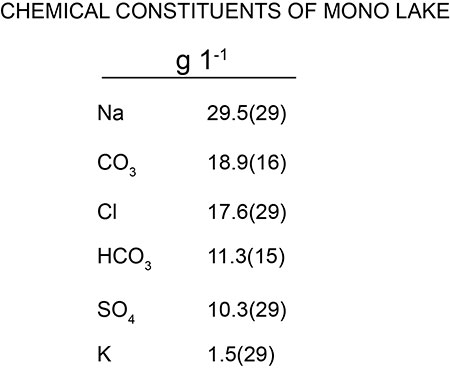
Water Chemistry: Mono Lake is about 3 times saltier than the ocean with an average salinity measure of 81 grams/liter (Quick Facts). The lake contains approximately 280 million tons of salt, which are primarily sodium chloride, but also include sodium sulfates and sodium carbonates (Hill). This also causes the lake to be 80 times more alkaline than the ocean, (Hill) with an average pH of 10 (Chemistry). Mono Lake water additionally contains unusually high concentrations of borate and potassium (Chemistry). The lake’s water also contains trace amounts of the following elements: strontium, magnesium, calcium, fluoride, arsenic, lithium, iodine, tungsten, uranium, thorium, plutonium, carbon-14, and more (Chemistry).
FIGURE 4: The major chemical constituents of Mono Lake (Winkler)
Water Properties: The surface water temperatures of the lake range from 2°C to 23°C. The top 10 meters of the lake water remain nearly a constant temperature throughout the lake (Winkler). In the fall, when the warm upper layer of the lake cools, it becomes more dense, and thus sinks. This is known as a lake turnover. This process effectively brings nutrients to the surface water, which is essential for the lake’s ecosystem (Mono Lake). The lake water has a rather high light penetration, measuring at a maximum of 8.5 meters below the water’s surface. The strong winds in the area cause the water to be quite turbid (Winkler).
Biotic Components
Algae: The algal community of Mono Lake includes cyanobacteria, phytoplankton, and diatoms, and can be categorized into two main groups: phytoplanktons and benthic algae (Mono Basin Ecosystem Study Committee). The two primary species of phytoplanktonic algae found in Mono Lake are Nitzschia communi and the green coccoid species of the genus Coccomyxa. These species are highly tolerant to conditions of high salinity, allowing them to thrive in Mono Lake’s hypersaline waters (Winkler). Small traces of several other algal species were also found. In terms of benthic algae (algae residing at the bottom of the lake), the predominant species are Nitzschia frustulum and Ctenocladus circinnatus (Mono Basin Ecosystem Study Committee). While the lake exhibits relatively low diversity of algal species due to the unusual and extreme chemical composition of the water, the dominant algal species in the lake are incredibly prolific and abundant (Winkler). As with all algae, Mono Lake’s algae are autotrophic, and thus via photosynthesis convert the sun’s energy into chemical energy, and in the process produce the much needed-oxygen. Therefore, algae is the foundation of the entire Mono Lake ecosystem.
Alkali Flies: The Mono Lake ecosystem is abundant in salinity-tolerant Ephydra hians, commonly known as alkali flies (Winkler). These flies have a dark brown to black body ranging from 4-7 millimeters in length. Fascinatingly, these flies can go underwater for up to 15 minutes. They achieve this as tiny hairs on the their bodies form an air bubble around themselves, allowing them to breath for an extended period of time. In this way, female flies enter the lake and lay their eggs on algal mats approximately 3 meters below the water’s surface (Simeone). When the egg hatches, the larva emerges and remains underwater for approximately 30 days, feeding upon detritus and benthic algae such as Nitzschia frustulum and Ctenocladus circinnatus (Simeone and Winkler). By this time they are ready to pupate. The larva often attach to a tufa formation and enter the pupa stage of 1-3 weeks in which the larva is surrounded by a sac, remains immobile, and does not feed. After the metamorphosis is complete, the adult alkali fly is fully mature and floats to the surface of the water and spends its remaining 2 weeks of its life on the shore of Mono Lake breeding, and returning to the water to feed upon algae (Simeone).
Brine Shrimp: Mono Lake is home to Artemia Monica, a species of Brine Shrimp that is found nowhere else in the world. In the absence of fish or any other aquatic predators, brine shrimp are tremendously fruitful and abundant. In the summer, there are an estimated 4-6 trillion brine shrimp in the lake. In the winter nearly all of the brine shrimp die off, but the females have laid tiny eggs of dormant, undeveloped embryos known as cysts. These cysts can withstand harsh temperatures (Brine Shrimp). The following spring these cysts hatch as microscopic larva known as nauplii. After 14 molts the larva has become a fully mature brine shrimp, (Winkler) which reach an approximate length of 1 centimeter (Mono Lake). The brine shrimp feed primarily upon the phytoplankton in the lake (Winkler).
Birds: Mono Lake, with brine shrimp and alkali flies in abundance and with two safe, isolated islands on the lake, is an ideal bird haven. This peculiar yet productive ecosystem has become a vital pit stop for migratory birds. Over 325 species of bird have been spotted at Mono Lake (Birds of the Basin), and in one individual day there has been counted an approximate 800,000 birds feeding at the lake (Young). Of these numerous birds, arguably the most significant is Larus Californicus, the gray-white bodied, black and white wing tipped California Gull (Bird of the Month at Mono Lake). Mono Lake hosts up to 50,000 California Gulls, which constitutes 95% of the state’s population. Seeking warmer weather in the winter, these gulls come to the islands at Mono Lake to breed, nest, and feed (Young). Another significant bird at Mono Lake is Podiceps nigricollis, the Eared Grebe. In winter, these black-necked birds with golden tufts behind their eyes migrate from northern US and Canada to the southern US and Mexico. Along the journey they stop at Mono Lake to feed upon brine shrimp and molt (Eared Grebe). Wilson’s Phalarope (Phalaropus tricolor) is another common bird of the Mono Lake ecosystem. These birds reside in the central US and central Canada. During summer, they fly to Mono Lake and stay there for 4-6 weeks molting their feathers and feeding upon algae, alkali flies, and brine shrimp to bulk up for their long journey ahead of them. They then embark upon a nonstop 3,000-mile flight to Ecuador (Wilson’s Phalarope). The California Gulls, Eared Grebes, and Wilson’s Phalaropes are the lake’s most common, consistent, and abundant avian visitors, but they are by no means the only. Millions of birds of hundreds of species visit the productive ecosystem of Mono Lake to rest, nest, breed and feed.
Larger Mammals: While the millions are birds are largely safe and protected, they do have a few potential predators. The Mono Basin biome and foodchain is also home long-tailed weasels, coyotes, and the occasional mountain lion (Mono’s Wildlife). There have been instances in which a land bridge formed, connecting the lake’s shore to the islands on which the birds nested. This land bridge allowed weasels and coyotes to prey upon the birds and their eggs (Winkler).
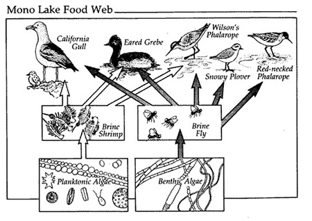
Food Chain
FIGURE 5: The food chain at Mono Lake (Botkin)
Figure 4 above depicts the food chain of the Mono Lake ecosystem. The diagram lacks the predators of the birds (mountain lions, weasels, and coyotes), but other than that the diagram illustrates the food chain succinctly and accurately.
Anthropogenic Effects
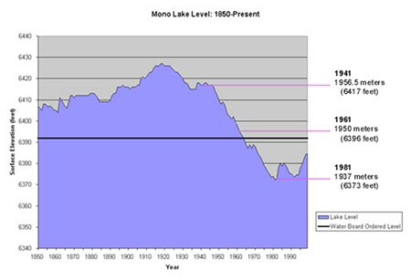
Water Diversion: In 1941, to provide water for its many citizens, the Los Angeles Department of Water and Power began diverting water from 4 of the 5 freshwater streams feeding into Mono Lake (The Mono Lake Story). These diversions caused a significant decline in lake water levels.
FIGURE 6: Graph showing the effects of anthropogenic water diversion (Mono Lake)
The lowered lake levels exposed once underwater lake sediments. These fine lake sediments were easily picked up by the strong winds of the basin, causing poor air quality for the area (The Mono Lake Story). In addition to poor air quality, the decreased lake level caused a significant increase in salinity, which severely threatened the life of brine shrimp and alkali flies. The lowered water levels also, late in the summer of 1978, dropped low enough to form a land bridge to Negit Island. The newly formed land bridge allowed coyotes to raid the island, wrecking havoc upon the birds’ once safe nesting place (Young). To address both the Mono Lake ecosystem and the growing water needs of Los Angeles, the Mono Lake Committee formed in 1978. They have set a target management lake level elevation of 6,392 feet above sea level. Since then they have strived to save Mono Lake restore its spectacular, priceless ecosystem (The Mono Lake Committee).
DISCUSSION AND INTERPRETATIONS
One of the most thorough mathematical models used to predict Mono Lake’s future was An Ecological Study of Mono Lake, California. The model predicted that if Los Angeles continued to divert water at its early 1970s rate of 100,000 acre-feet per year, the lake levels would drop rapidly until they reached a stabilized level of 6,323 feet above sea level, over 50 feet lower than current levels. This decline would cause the lake to lose 46% of its surface area and 71% of its volume, along with exposing 20,000 acres of lakebed. The study also calculated that if Los Angeles had never diverted water, the lake would be safe, sitting at about 30 feet above the current level. Additionally, the mathematical model projected that to stabilize the lake at the level desired by the Mono Lake Committee, Los Angeles would have to cut its diversions by approximately 75% (Winkler). Considering the current water diversion reductions and average precipitation of the region, the Mono Lake Committee has hypothesized that Mono Lake will reach its management level in 2021 (Mono Lake Committee). However, this prediction is threatened as the rising lake levels have been stymied due to the state of California facing a 3-year and counting drought. This drought has been attributed to global warming by many. Whether or not the drought is a result of global climate change, the fact of the matter is the well-being of Mono Lake is being considerably threatened. If the patterns of drought continue and the lake levels continue to drop, the important, unique, vibrant ecosystem of Mono might be extinguished. The story of such an incredible ecosystem portrays that these biomes can be delicate, and that human intervention can cause significant detriment to them, either directly via water diversion or arguably indirectly via global warming due to the excessive burning of fossil fuels. Mono Lake’s story can serve as warning to the ecosystems of other terminal lakes, such as the Great Salt Lake. Terminal lakes are sites of unique geology and ecology and are priceless in terms of scientific studies. And as evident in the story of Mono Lake, while these ecosystems can be fragile, it must be remembered they are certainly worth the effort to preserve. Hopefully humans learn from the struggles to restore and preserve Mono Lake, and exhibit precaution and care in dealing with unique, invaluable ecological sites.
Conclusion
The Mono Basin is a site of important geological history due to its unusual amalgamation of tectonics, volcanism, and hydrology. The basin’s unusual geology and geography have created the extraordinary Mono Lake, with an ecosystem unrivaled in productivity and peculiarity. The lake is one of the oldest lakes in America, in addition to being among the most saline and alkaline. To set it apart even more, Mono Lake is said to be the only location to have tufa towers of thinolite and Artemia Monica, the species of brine shrimp in the lake. Additionally, Mono Lake is a crucial site of food and refuge for millions of migratory birds. Thus, considering its environmental importance, overall uniqueness, and value to ecological and geological studies, Mono Lake needs to be restored and protected.
Works Cited
"Birds of the Basin." About Mono Lake. Mono Lake Committee, Web. 07 June 2014. website.
"Bird of the Month At Mono Lake." www.monolake.org. Mono Lake Committee, 2014. Web. 13 June 2014. website.
"Bird of the Month At Mono Lake." www.monolake.org. Mono Lake Committee, 2014. Web. 13 June 2014. website.
"Chemistry" About Mono Lake. Mono Lake Committee, Web. 07 June 2014. website.
"Brine Shrimp." About Mono Lake. Mono Lake Committee, Web. 07 June 2014. website.
Bursik, Marcus, and Kerry Sieh. "Most Recent Eruptions of the Mono Craters, Eastern Central California." Journal of Geophysical Research: Solid Earth 91.B12 (1986): S 12,539-12,571.
"Cowtrack Mountain." Summit Cheeseburger. N.p., 07 June 2014. Web. 12 June 2014. website.
"Eared Grebe." www.monolake.org. Mono Lake Committee, 2014. Web. 13 June 2014. website.
Hill, Mary. Geology of the Sierra Nevada. Berkeley: University of California Press, 2006.
"Introduction to the Basin and Range." EarthScope Voyager. UNAVCO, n.d. Web. 15 June 2014. website.
John, D.A. "Geologic Map of the Bodie Hills Volcanic Field, California and Nevada." SAO/NASA ADS Physics Abstract Service. American Geophysical Union, Dec. 2011. Web. 12 June 2014. website.
"Long Valley Caldera Field Guide - Mono Lake." Volcano Hazards Program. USGS, n.d. Web. 15 June 2014. website.
"Mono Basin Creek Profiles." Mono Basin Clearinghouse. Mono Lake Committee, 2014. Web. 12 June 2014. website.
Mono Basin Ecosystem Study Committee. National Academy of Sciences Report on the Mono Lake Ecosystem. Washington, D.C.: National Academy, 1987.
"Mono Lake." Ecoscenario: Mono Lake. Populations and Ecosystems, Web. 07 June 2014. website.
"The Mono Lake Committee." About Mono Lake. Mono Lake Committee, Web. 07 June 2014. website.
"Mono Lake Level." About Mono Lake. Mono Lake Committee, Web. 07 June 2014. website.
"The Mono Lake Story." About Mono Lake. Mono Lake Committee, Web. 07 June 2014. website.
"Mono’s Wildlife." About Mono Lake. Mono Lake Committee, Web. 07 June 2014. website.
"Mono-Inyo Chain." Volcano Hazards Program. USGS, n.d. Web. 15 June 2014. website.
"Quick Facts." About Mono Lake. Mono Lake Committee, Web. 07 June 2014. website.
"Rain Shadow." National Geographic Education. National Geographic Society, n.d. Web. 12 June 2014. website.
Rieger, T., 1992, Calcareous tufa formations; Searles Lake and Mono Lake: California Geology, v. 45, no. 4, p. 99-109.
Schweich, Tom. "Mono Basin." Mono Basin, Mono County, California. N.p., 22 May 2014. Web. 07 June 2014. .
Scoonover, Mary. "Mono: The Lake, the Legacy." Environs 18.1 (1994): 26-34. Web.
Simeone, Mono. "The Biogeography of Mono Lake Alkali Fly." San Francisco State University Department of Geography. N.p., Dec. 2011. Web. 12 June 2014. website.
"Virga." Oxford Dictionary. Oxford University Press, n.d. Web. 12 June 2014. website.
"Wilson’s Phalarope." www.monolake.org. Mono Lake Committee, 2014. Web. 13 June 2014. website.
Winkler, David W. "An Ecological Study of Mono Lake, California." Institute of Ecology Publication 12 (1979): n. pag.University of California, Davis. Web. 10 June 2014.
Young, Gordon. "The Troubled Waters of Mono." National Geographic 160.4 (1981): 504-519. Web. 7 June 2014.
[Return to Research Projects] [Return to Sierra Home]