Geology and Natural Heritage of the Long Valley Caldera
Geology and Climate of the Mono Basin: An Analysis of Historic and Present Issues in the Mono Basin and at Mono Lake
Becky Ferber
Abstract
The Mono Basin is studied widely by geologists for its volcanic history, and within the basin lies Mono Lake, an equally intriguing point of study for scientists, environmentalists, and researchers worldwide. This paper summarizes and explains the primary issues and points of intrigue surrounding the Mono Basin. From recent volcanism to even more recent political debate, the Mono Basin contains the youngest volcanoes in the United States as well as a threatened ecological system at Mono Lake, where tens of thousands of birds make their nests. The last three years of low rainfall, now categorized as a drought, have put an already fragile ecosystem in more danger. In analyzing the geology and ecology of the basin, this paper seeks to understand the extent of the impact that both anthropogenic and natural forces have had on the Mono Basin.
Introduction
Mono Lake – an alkaline Lake that rests between the Great Basin and the Sierra Nevada Mountain Range – has a complex geological and political history, as well as an equally interesting and delicate future. This lake, which is home to trillions of brine shrimp and alkali flies and serves as a nesting ground for over one hundred species of birds, has been a source of immense political debate over the years, as members of the Los Angeles Department of Power have contended with environmentalists and ecologists regarding the use of the five freshwater streams that feed into the salt lake.
Regional Background: Geology, Climate, and Ecology of the Mono Basin
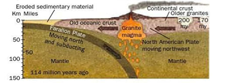
The geology of Mono Lake is particularly unique, as it lies on the eastern edge of the colossal Sierra Nevada Mountains and on the westernmost edge of the basin and range province, just north of the Long Valley Caldera. 150 million years ago, the convergence of the oceanic Farallon plate and the continental North American Plate caused the Farallon plate to sink underneath the North American plate, forming a subduction zone of hot magma and volatiles that overtime uplifted to form the Sierra Batholith—the large body of granitic igneous rock that makes up the core of the Sierra Nevada mountain range (Hill, 179). Today, although the Farallon plate has been entirely lost underneath the North American plate, tectonic activity still impacts the Sierra Nevada range, as the Pacific plate slide past the North American plate at the transform boundary of the San Andreas Fault.
Subduction of Farallon Plate and Formation of Sierra Batholith (Hill, pg 180)
The Sierra Nevadas have an immense impact on the climate of the Mono Basin. Large mountain ranges such as the Sierras create a rain shadow, in which the cool air on top of the mountains drops large amounts of precipitation in the form of snow, but once past the mountains, warms and causes the clouds to dissipate (National Geographic). This dissipation of clouds on the rain shadow side of the mountain prevents large amounts of precipitation from falling on that side—in the case of the Sierra Nevadas, the basin and range. The rain shadow side of the mountain thus becomes dry and arid.
So, Mono Lake, which lies on the rain shadow side of the Sierra Nevadas, already faces the reality of little precipitation – it receives on average 5–7 inches of rain each year (http://www.monolake.org/about/stats). Rather than rely on rain as a water source, Mono Lake is renewed by five streams that flow down the eastern side of the Sierra. These streams are the primary inputs to the lake, as rainfall is scarce in the region. Furthermore, the Mono Basin is a terminal basin; that is, no streams or rivers flow out of the region and into a larger source. All of the non–water materials that are brought into Mono Lake by these streams then remains in Mono Lake, as only the water evaporates out. It is this geologic landform of a terminal basin that makes Mono Lake saline in the first place, as when the water evaporates from the lake, salt is left behind with no outflow to carry it to the ocean. The high salinity of the lake makes it impossible for most species to inhabit; there are no fish in Mono Lake. But trillions of brine shrimp and alkali flies reside at Mono Lake, feeding on algae and depending on the salinity of the water for survival. Further, Mono Lake is home to 85% of the California Gull population as well as a critical stopping point for migratory birds such as eared grebes, northern phalaropes, and Wilson’s phalaropes (Winkler iii).
Volcanic Features
The geologic history of the mono basin is younger than that of the Sierras, ranging from one to three million years old. Crustal stretching at the divergent plate boundary creates the basin and range, of which the Mono Basin is apart. The north, south, and east sides of the basin consist of volcanic landforms, including the Mono Craters – the youngest volcanic chain in North America. In fact, Panum Crater, which is the northernmost of the Mono Craters, erupted only 640 years ago (USGS). According to the US Geological Survey, the first eruption at Panum Crater was steam-based, or phreatic. This phreatic eruption blew out lake sediments that rested at the top of the volcano, depositing them in mounds throughout the area and creating a crater where the blown out debris used to be. An eruption of pyroclastic flow followed the steam eruption, resulting in the deposits of ash and pumice from the cooled magma. Finally, the eruption was finished with a lava dome style eruption, in which lava oozed out of the volcano following the more explosive eruption. This oozing of magma creates a dome shape, and while the lava dome is hardening, more lava escapes through cracks in the surface, resulting in tall spires. Throughout Panum Crater clasts of both pumice and obsidian can be found, as these varying rhyolites form based on the degree to which the magma cools (USGS).
Negit and Paoha – the two islands in the center of Mono Lake – are both volcanic. Negit, which is the smaller of the two islands, has experienced eruptions as late as 1,700 years ago to as recently as 250 years ago. The larger island Paoha formed roughly 300 years ago, when magma pushed lake bottom sediments upwards. The white deposits on the island are markers of this lake sediment, while the darker rocks on the northeast and southeast corners have been formed by flows from the volcanic cones that formed the island. Paoha Island contains steam vents and fumaroles, which have lead geologists to believe that the island may not in fact be dormant. (Winkler 8).
The landform known as Black Point that lies on the northwestern shore of Mono Lake is a cindercone volcano that erupted much earlier than the other volcanoes in the Mono Basin, some 13,500 years ago (USGS). This eruption occurred during the Great Ice Age, at which time Mono Lake was nearly five times its current size, leaving Black Point underwater. Today, the water level is much lower than it was during the ice age, exposing the lake sediment from this ancient lake. However, the weight of the water on top of the volcano has flattened its top, and deep fissures run north to south along Black Point.
Mono Lake, Stream Diversions, and an Emblazoned Political Battle
Mono Lake itself is at least 760,000 years old, and in this time the lake level has varied drastically (Monolake.org). During the Great Ice Age, Mono Lake was over 900 feet deeper than it is today, so the Black Point, Negit, and Pahoa would not have been exposed above water. Yet, while lake level has dropped drastically over these 760,000 years as a result of changing climate and glaciation, it is anthropogenic forces that have had certainly the most concerning impacts on Mono Lake’s level. That is, as a result of stream diversion from four of the five input streams, the Los Angeles Department of Water and Power has severely altered Mono Lake’s water level, threatening an entire ecosystem and an important geological feature.
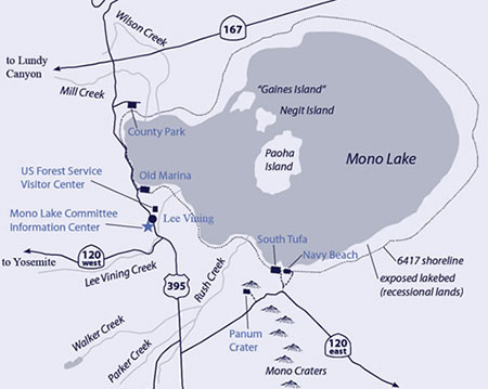
Map of Mono Basin shows four input streams into Mono Lake: Rush Creek, Lee Vining Creek, Mill Creek, and Wilson Creek (Monolake.org)
In the 1930s, when the city of Los Angeles realized they would eventually need to increase their water supply, the city bought up large plots of the land, and thus the water rights, in the Mono Basin. It was not until 1941 that the Los Angeles DWP began diverting Mono Lake’s tributaries in 1941, a result of an increasing Los Angeles population and little rain or localized water sources to meet the growing demand for water. So much water was diverted, that the level of Mono Lake dropped by nearly fifty feet in fifty years, its salinity increasing from 51.3 g/l to 99.4 g/l (Monolake.org.about/story). The drastic drop in lake level exposed 18,500 acres of lakebed that had previously been underwater, as well as revealing the lake’s tufa structure, which formed when calcium from fresh water springs came in contact with the carbonate–rich lake water, forming white limestone deposits of calcium carbonate (Monolake.org.about/story). The drop in lake level and the effects it had on both the salinity and the level of the lake posed extreme problems for the ecosystem.
One of the primary threats to the ecosystem came from land bridges that formed as the lake level dropped from Mono Lake’s islands to its shore. Where birds had preciously come to nest and avoid the threat of predation, they now found coyotes and other predators able to reach this land. In fact, when the land bridge became exposed in 1978, the National Guard attempted to destroy the bridge with explosives in order to protect nesting birds, but to no avail. Furthermore, the increased salinity of the lake impaired both brine shrimp reproduction rates and photosynthesis capabilities for the lake’s algae, ultimately impacting the amount of food sources available for both the alkali flies and the birds that inhabited the area (Winkler 2). According to a 1981 National Geographic article, the increasing salinity of the lake had caused ducks and geese to leave the lake entirely, so that it became "hard to find even one out there now" (National Geographic). And finally, decreased lake level also impacted air quality in the Mono Basin, as alkali–dust that rested on the newly exposed lakebed became picked up by winds.
By the 1970s, members of the local Lee Vining community and environmentalists around the globe decided that they could no longer let Mono Lake be dried up by the Los Angeles DWP. In 1978, teaching assistant at Stanford University David Gaines formed the Mono Lake Committee in hopes of increasing awareness about the importance of the lake in a major conservation and preservation effort. Their Summer 1987 Mono Newsletter dedicated the committee "to the preservation of the scenic and wildlife values of Mono Lake, California." The newsletter from the following fall expanded that mission to also preserve "scientific values of Mono and other Great Basin lakes by limiting water diversions to levels that are not environmentally destructive, to further public interest in the natural history and preservation of these lakes, and to facilitate relevant research."
What began as a small environmental organization soon became a strong opponent in a heated legal battle with the City of Los Angeles. In 1979 the Mono Lake Committee was joined by the Audubon Society, which proclaimed Mono Lake as a high priority campaign, and together they campaigned to protect Mono Lake and reverse the damage of the stream diversions. Their lawyers argued that the immense stream diversions of the Mono Lake tributaries violated the public trust doctrine, which, according to the California Supreme Court, states: "the duty of the state is to protect the people’s common heritage of streams, lakes, marshlands, and tidelands" (Mono Lake Newsletter, Summer 2014). So, after over a decade of fighting with the LADWP, on September 28, 1994, the California State Water Resources Control Board issued Order D1631 to protect Mono Lake and its tributaries. All streams would be mandated to maintain minimum flow levels, and a Mono Lake stabilization plan was put in place to raise the level by 17 feet to 6,392 feet above sea level. It was expected at the time that it would take approximately 20 years for the stabilization level to be reached (reference website). This monumental decision, truly for the first time, took ecosystems as unique as Mono Lake’s into consideration regarding water distribution. Launching this new era marked by compromise between humans and animal populations would require the DWP to restore much of the damage that it had created in the Mono Basin. The chart below shows just how much damage the DWP would have done to Mono Lake, had it continued its unrestricted diversions.
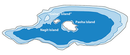
The dark blue represents what Mono Lake might have looked like at 6360’ if DWP diversions had continued at their full, unrestricted, historic levels. The lightest blue represents pre-diversion Mono Lake, at 6417 feet above sea level, and the medium blue represents Mono Lake’s current level of 6380’. (Mono Lake Committee)
The Drought and Mono Lake Today
Today, Mono Lake is at a level of 6,380 ft, still below the stabilization level (Monolake.org). Reaching this stabilization level has proven to be more complicated than imagined, as despite political successes and negotiations with the Los Angeles DWP, setbacks still occur. Although Order D1631 marked a compromise between the DWP and the Mono Lake Committee’s goals, seeking to continue providing water to the city of Los Angeles but in a more managed and restricted way, the DWP does not always follow the rules and restrictions that have been outlined for them by the California Supreme Court. For example, the Grant Lake Operations and Management Plan (GLOMP), states that water from the lake can be exported year-round at a constant rate of 22 cubic feet per second. This past spring, however, the DWP exported 150 cfs during the months of April and May (Mono Lake Newsletter, Summer 2014). Since Grant Lake serves as a reservoir for Rush Creek, its increased amount of water exportation will negatively impact the amount of stream flow from Rush Creek into Mono Lake, setting back plans of lake and stream restoration.
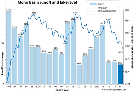
Natural causes have also played their part in delaying the stabilization of the Mono Lake level. For the past several years, snowfall in the Sierras has been well below average, leaving less and less runoff in Mono Lake’s tributaries. The past three years have been the third driest in California history, just behind the droughts of 1928-31 and 1974-1977 (Mono Lake Newsletter Summer, 2014). The graph below shows Mono Lake’s runoff as a percentage of the average and the impact that it has had on the lake level.
Mono Lake rises and falls according to wet and dry years; its progress since the 1994 State Water Board decision has not been a straight-line trajectory. However, long-term, Mono Lake is on the rise to the management level of 6392 feet above sea level. (Mono Lake Committee)
In January of 2014, California Governor Jerry Brown declared the state in a drought emergency, while the US Department of Agriculture named nearly half of California’s counties–including Mono County–as natural disaster areas (Mono Lake Newsletter, Spring 2014). Greg Reis of the Mono Lake Committee predicts that this dry period will be a major setback in the restoration of Mono Lake to stabilization level. In addition to impacting the timeframe in which this level can be reached, drought will undoubtedly increase the severity of dust storms from the newly exposed lakebed, and the water may be shallow enough in some places for coyotes and other predators to reach the nesting places of the California gulls and other important birds to the Mono Lake ecosystem (Mono Lake Newsletter, Summer 2014).
If the level of Mono Lake does not reach 6,380 feet by April 1, 2015, whether a result of anthropogenic or natural causes, the DWP will face severe cutbacks in the amount of water it can divert from Mono’s streams. Currently, the DWP can export 16,000 acre-feet per year from Mono Lake’s tributaries, but if these cutbacks were to occur, the DWP would be restricted to 4,500 acre-feet of export (Mono Lake Newsletter, Spring 2014). If the lake level were to continue falling further and reach a level as low as of 6,377 feet above sea level, the DWP would be completely cut off from diverting Mono Lake’s tributaries to Los Angeles. So, both ecologists concerned with protecting the ecosystem and stabilizing Mono’s lake level as well as members of the DWP concerned with diverting a certain amount of water to provide to the city of Los Angeles are hoping for a wet winter and an end to this three year dry period that has had a severe impact on the Mono Basin.
Conclusion
Water has long been an issue in the state of California, and its inhabitants are not unfamiliar with droughts. Largely a result of the Mono Lake decision in 1994, Los Angeles has become extremely efficient in its use and conservation of water. Today, it is the lowest per-capita water consumer of any large city (over one million residents), and per-capita residential water use is under 85 gallons per person per day (Mono Lake Newsletter, Spring 2014). Working with the Mono Lake Committee, residents and politicians in Southern California have worked to increase conservation efforts and raise awareness about water issues throughout the state. As a result, Los Angeles residents have grown more conscious of their water sources, including that of Mono Lake. So, despite small struggles between the DWP and the Mono Lake Committee as well as natural setbacks in the restoration of the Mono Lake level, ultimately this educated community combined with a perseverant group of environmentalists will manage to maintain the ecological and geological integrity of the Mono Basin. In a region that has existed for over 700,000 years, a three-year drought and even a 70-year diversion project will not be able to destroy what David Winkler denotes as "one of the most beautiful and scientifically interesting regions in California," marked by its "granite escarpments, glacier-scoured canyons, volcanoes, and lava flows…dominated by the blue expanse of Mono Lake" (Winkler i).
Works Cited
"About Mono Lake." About Mono Lake. N.p., n.d. Web. 07 June 2014.
"America’s Volcanic Past Long Valley Vicinity, California." CVO Menu. N.p., n.d. Web. 07 June 2014
Hill, Mary. Geology of the Sierra Nevada. 2nd ed. Berkley, CA: University of California Press, 2006. Print.
McQuilkin, Geoffrey. "The State Water Board decision at 20." Mono Lake Newsletter Summer 2014. Web.
Miller, Bartshé. "Mono Lake Amidst a Drought." Mono Lake Newsletter Winter-Spring 2014: Print.
Miller, Bartshé. "Olympic Dry." Mono Lake Newsletter Summer 2014. Web.
"Mono Lake Background Information." Mono Lake Background. N.p., n.d. Web. 07 June 2014.
"The Mono Lake Story." The Mono Lake Story. N.p., n.d. Web. 07 June 2014.
"Quick Facts About Mono Lake." Quick Facts About Mono Lake. N.p., n.d. Web. 07 June 2014
"Rain Shadow." National Geographic Education. N.p., n.d. Web. 04 June 2014.
"USGS: Volcano Hazards Program - Long Valley Caldera Field Guides: Panum Crater." USGS: Web. 07 June 2014.
Winkler, David W. "Mono Lake Committee." Lee Vining, CA: n.p., 1979. N. pag. Print. Rpt. of "An Ecological Study of Mono Lake, California." Institute of Ecology 12
[Return to Research Projects] [Return to Sierra Home]