Geology and Natural Heritage of the Long Valley Caldera
The Great Diversion Project in the Owens River Valley and Mono Lake Area: Origins, Processes, and Challenges
Ingrid Barce
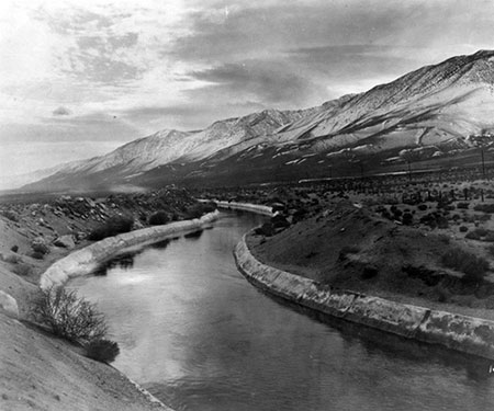
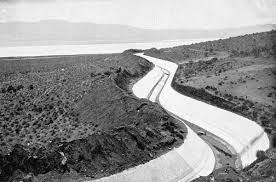
View of the Los Angeles Aqueduct in the Owens River Valley. Reproduced from the Department of Water and Power, 2012.
"It is no stretch of the imagination to say that Mono County will take its place in the foremost ranks of the counties of California in the very near future." Mono County: The Land of Promise, 1908 "California’s water system might have been invented by a Soviet bureaucrat on an LSD trip." -Peter Passel, "Economic Scene: Greening California" New York Times 1991.
Abstract
In the early 1900s, the city of Los Angeles looked to the future and began to prepare for a long term investment in water resources as the city’s population began to grow rapidly. California is notoriously lacking in water resources, which became especially apparent after the gold rushes began in the mid-1800s. To address their needs, Los Angeles turned its attention to the north, where high elevation and locations within the Sierra Nevadas had potential to provide much needed water and power. This paper will focus on one of Los Angeles’ major projects to produce water, the Mono Lake and Owens River Valley diversion project. Over the course of the paper, the reason for why water was needed so badly in Los Angeles, how the city mitigated this need with the Mono Lake diversions, and some of the challenges that the city and area that was being tapped had to cope with will be addressed to provide a comprehensive picture of the interactions between geology, politics, economics, and geography in the Sierra Nevadas and Los Angeles.
Introduction
Overview of the Mono Lake and Owens River Valley Area
Both Mono Lake and the Owens River Valley are located within the Basin and Range Region, an area that covers most of eastern California, Nevada, Utah, and Arizona. The Basin and Range region is characterized by a series of mountain ranges and basins oriented in a general north to south direction. The unique topographical feature is a result of crustal stretching which is also evidenced by numerous faults that run throughout each basin. Mono Lake is located at the northern edge of Long Valley and the Owens River Valley is found south of Long Valley. Both are bounded by mountain horsts on each side, in this case, the Sierra Nevadas on the western edge and another lower range on the east. Unlike other basins in the region, Long Valley is volcanically active and the faults found in the valley are often situated near or on volcanic vents. (Sorey, Lewis, and Olmsted, 1978). Due to their lower elevation and glaciation hundreds of thousands of years ago, each valley used to be filled by a lake. Today, Mono Lake is still present, though it has been on the verge of destruction, and Owens Lake has completely disappeared due to the water diversion projects by Los Angeles.
Why Los Angeles Needs the Mono Basin
Because Mono Lake and Owens Lake are on the Eastern side of the Sierra Nevadas, they fall within the rain shadow meaning that both lakes receive very little rain as a source of freshwater input. As Los Angelesdiverted more and more water, Mono Lake became increasingly saline to the point of almost being unviable for its fairly simple food chain, while Owens Lake dried up almost completely, leaving extremely alkaline, dry soil that can only be populated by a few species of plants. However, the location of both valleys is extremely valuable because both not only produce water, but also can produce hydroelectric power due to the high elevation from which the water originates.
Other Diversion Projects
As a steady stream of people flowed into the state, officials in Southern California recognized that their portion of the state lacked the surface water that would be necessary to replenish their aquifers at the current rate of growth. Like many of the other cities in the region of Los Angeles, the issue of water is compounded by historically little rainfall, long dry periods, and few sources of freshwater. As a result, the city of Los Angeles draws water from locations around the western United States. A major source for water is the Mono Lake and Owens River Valley aqueduct. However, another major diversion project was authorized in 1928 by Congress that includes the Hoover Dam, the Imperial Dam, the All-American Canal, and most importantly for Los Angeles, the Colorado River Aqueduct. Instead of being managed by Los Angeles like the water coming from the Mono Lake area, the water that comes from the Colorado River Aqueduct is managed by the Metropolitan Water District of Southern California. (Hanak, 2011) where it is then distributed among Los Angeles for urban use.
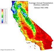
Precipitation map of California. Figure reproduced from the Oregon Climate Service (1995)
Focus
In this paper I will strive to answer three main questions, first, why was the diversion project in the Mono Basin needed?; second, how was diversion from Mono Lake achieved?; and third, what were some of the geologic and geographic challenges that were faced during the construction of Los Angeles’ Aqueduct?
Why Was the 1940s Diversion Project in the Mono Lake Area Needed?
The Need for Water
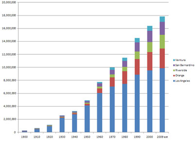
Los Angeles is not a prime site for a city in terms of resources, especially water. The city sits on a coastal plain and is surrounded by desert on three sides and the Pacific Ocean on the fourth. Unlike other major cities like New York, New Orleans, or Chicago that have plenty of access to water for shipping, industry, and supporting a significant human population, Los Angeles only has a very small, not very viable Los Angeles River. During pueblo times when the Spanish occupied California, the site could have supported a small trading outpost, however, as the population soared into the hundred thousands, then the millions in the early twentieth century, city officials quickly realized that they needed a reliable source of water to support the burgeoning population. According to Mark Wheeler, author of California Scheming, at the turn of the twentieth century, California had the nation’s fastest growing economy and population as people flocked to the coast in search of jobs and new opportunities, especially during the Great Depression. The surge in souls would cause numerous legal problems in the formative years of Los Angeles as it battled with neighboring cities and agricultural operations for control of the water resources.
Population growth in Southern California. Los Angeles is demonstrated by the light blue bar. Figure reproduced from the Center for Global Geography Education, 2008.
Legal Concerns
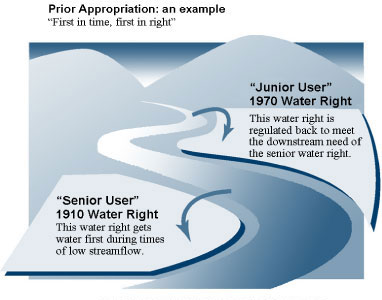
Early in water saga of California, the state Supreme Court made several key decisions that would shape the development of water allocation throughout the twentieth century and into the twenty-first century. One of the major rulings in the nineteenth century was the decision to uphold ancient Spanish pueblo laws that gave a city the right to make the first claims on all the native waters of a source that was located within the city (Hanak, 2011). In the case of Los Angeles, that decision meant that the city had the right to all the native waters of the Los Angeles River, which it would use to its advantage in the 1880s when the city sued its neighboring cities for the absolute right to all the groundwater basins that were connected to the river. That decision would be decisive to the fate of the Owens River Valley thirty years later. Another critical component of California water law was the decision to uphold both riparian rights and the system of prior appropriation. Riparian rights give a settler the right to access water that is located along their land for their use while prior appropriation is simply the concept of "if you claim it first, it’s yours" (Babb, 1992). These two systems are an interesting mix of both old and new as riparian rights are a part of the archaic English Common Law that was incorporated into California’s legal system in the 1850s and prior appropriation which was developed initially by miners. Currently, the balance between riparian rights and prior appropriation has been decided that those with riparian rights have the first claim to natural waters and then after the riparian demands are met, those with prior appropriation may take the remaining water (Hanak, 2011). Again, this decision and the balance between these rights will have a major impact on both the Mono Lake area and the Owens River Valley.
Representation of the concept of prior appropriation. Reproduced from the Water Resources Department, Oregon, 2005.
Depletion of Other Water Sources
When the decision to extend the aqueduct from the Owens River Valley was made by the citizens of Los Angeles, a considerable amount of damage had been done to the original site of the aqueduct around Owens Lake and the groundwater basins around the city. Many of the natural groundwater basins near Los Angeles had already been depleted far below a sustainable level and the Los Angeles River was neither a significant source of freshwater nor a reliable. Not much time passed, either, in the Owens River Valley before locals started noticing a dramatic drop in water level, over ten meters in just twelve years (Babb 1992). Bekedam (1997) found that due to the city’s right of prior appropriation, Los Angeles was allowed to exhaust every possible source of water in the valley from input streams, to groundwater basins, to runoff in times of excess. The absolute diversion of major water input sources caused a critical depletion, over time, of available water and thus has had a significant detrimental effect on the local ecosystem. As Owens River Valley locals grew increasingly agitated and water levels dropped lower and lower, the city of Los Angeles looked to the north for new sources of freshwater.
Why Mono Lake Was Chosen
Besides being a natural extension north, Mono Lake seemed to be a fairly easy choice for city officials to push into to divert water. There are four major streams that flow down from the Sierras, Rush, Lee Vining, Mill, and Gibbs Canyon Creeks, and, at the time that the site was surveyed, there were few inhabitants around Mono Lake that could interfere with plans for diversion. When surveyed by engineers, officials concluded that, unlike the fiasco at Owens River Valley, Mono Lake would only be reduced to one third of its original size before it would reach equilibrium between diversion and natural springs that fed into the lake (Van Norman, 1936). Of course, the impact on Mono Lake’s ecosystem was never really factored into the decision to divert the lake nor was the impact that a major reduction in area size would have on the massive avian breeding grounds for which Mono Lake is famous. Additionally, when the decision was made in May 1930 to fund the project, California was coming out of a major drought and in Los Angeles particularly, the population had soared to a half million in just a few short decades. So, facing limited resources and recognizing a potential solution to a serious problem, Los Angeles pushed forward with their aqueduct into the Mono Basin.
The Los Angeles Aqueduct next to a filled Owens Lake. Reproduced from weirdca.com, 2004.
How Was the Mono Lake Diversion Project Achieved?
Owens River Valley Origins
Beginning in 1908 and completed in 1913, the Owens River Valley was a highly controversial project carried out by Los Angeles’ Department of Water and Power. To gain unlimited access to the valley, Fred Eaton and William Mulholland, a former mayor of Los Angeles and the Chief Engineer of the Los Angeles Aqueduct respectively, personally traveled to the site of the aqueduct to buy up the land in the valley. To help circumvent some of the local rancher’s suspicion about a massive land grab, Eaton personally purchased most of the land in the valley before transferring it to the city. (Wheeler, 2002). What little land left in the valley was subsequently purchased in the next few decades by Los Angeles so that the Department of Water and Power could also tap the subterranean groundwater basins. Sooner rather than later, however, protests became heated as the level of Owens Lake crashed. Before the diversion project began, the Owens River Valley was used for cattle ranching, but after, the area became so desiccated that it is plagued by dust storms, to this day, that throw massive amounts of parched valley floor into the air. Due to lack of regulation at the time of diversion in the Owens River Valley, Los Angeles is now having to reinvest resources into reinvigorating the destroyed ecosystem.
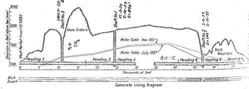
The Mono Craters Tunnel Project
In order to reach the water resources of the Mono Basin, engineers had to cut a tunnel through the Mono Craters that was over eleven miles long, a major feat of engineering. Throughout the construction of the tunnel, several world records were even set. Multiple times, the first in 1935, a record was set for hard rock tunnel drilling which measure the feet drilled through solid rock per day. On average, workers could drill about nineteen feet per day, but on the day that the records were set, about ninety feet were drilled Van Norman, 1936). Progress was crucial for the engineers so they maximized the use of labor and technology as much as they could. According to site reports by Wyckoff, a chief engineer on the project (1938), throughout the course of drilling, six headings were begun that would all meet in the middle of the main tunnel and workers were kept on site twenty-four hours of the day in three, eight hour shifts. Those that had engineered the initial Owens River Valley had the foresight to plan for potential enlargements in the water carried to Los Angeles. One of the main purposes of tunnel construction was to increase the water supply by roughly 145 second feet to bring the aqueduct to its full carrying capacity of 480 second feet (Jacques, 1939). Problems encountered with the geology of the Mono Craters will be discussed later in the paper. The tunnel itself is remarkable, but the entire Los Angeles aqueduct system is equally impressive.
Labor and Technical Aspects of Construction
The Los Angeles Aqueduct is a modern marvel by itself, carrying water from the High Sierras hundreds of miles down to the city of Los Angeles. Starting in the Mono Basin, the diverted streams flow down to Grant Lake, through the Mono Craters Tunnel, where it then joins the Owens River where it flows into Lake Crowley. After reaching Lake Crowley, the water enters a pipeline to flow into the Pleasant Valley Reservoir in Owens Valley where it is held until the city lets the water run down to the Haiwee Reservoir, from where it is utilized for urban use (Hollet, 1991). The gargantuan scale of the project is remarkable, but even more so when one considers the extremely low number of fatalities on the job, given the harsh conditions with which workers had to cope. One of the engineers of the project, Van Norman (1936), wrote to his supervisors in Los Angeles that every provision has been made for the comfort and welfare of the men. An excerpt from the camp records (Jacques, 1939) of the construction team working on the Mono Craters Tunnel Project, the level of care becomes clear from the libraries created for the families of the workers and state of the art hospital established should there be a major accident, to name a few commodities. During the work day, supervisors also took hazards on the job into consideration. When dangerous vents of carbon dioxide were found in the Mono Craters, Wyckoff (1938) notes that a rescue team was assembled, specifically designed to handle those affected adversely by the gas. The construction Los Angeles Aqueduct was not only a feat of engineering, but a marvel of labor and technological management.
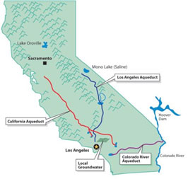
Map of the Los Angeles Aqueduct. Reproduced from the Sierra Club, 2006.
Key Figures in the Diversion Project
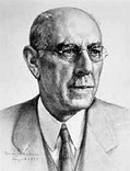
Fred Eaton: Eaton was the mayor of Los Angeles at the turn of the twentieth century. During his time in office, he, like many others, recognized the growing need for a reliable source of water. After he was out of office, he continued to be a proponent of the Los Angeles Aqueduct and travelled to the Owens River Valley with William Mulholland to buy the land that would later support the aqueduct.
Fred Eaton. Reproduced from the LADWP, 2014
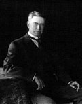
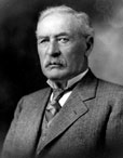
William Mulholland: Starting from a lowly position in the Los Angeles Department of Water and Power, Mulholland taught himself engineering and rose to become the chief engineer of the Owens River Valley diversion project in the DWP. He is responsible for completing the most difficult engineering project ever undertaken by an American up to that point in history within the original time and within budget. (LADWP, 2014).
William Mulholland. Reproduced from the LADWP, 2014
J.B. Lippincott: Though his name is not often associated with the diversion project, Lippincott played a critical role in the buy up of the Owens River Valley. While Los Angeles was charging forward with their quest for water, the state of California has also enlisted the federal government to assist with a massive reclamation project to help the State Water Board access water as well. While in the Owens River Valley, Eaton persuaded Lippincott to allow him access to the land records which allowed Eaton to acquire some of the land that had been marked for the federal reclamation project (Hanak, 2011). The federal land that Eaton failed to acquire was later leased to the city of Los Angeles.
J.B. Lippincott. Reproduced from University of California, Berkeley, 2013
What Were the Geological and Geographical Challenges of the Diversion Project?
Volcanic Geology of the Mono Craters
Tunneling in the Mono Craters provided a valuable record of the geologic history of the area. Jacques (1939), the engineer of the major construction of the project noted that volcanic ash could be found from the surface down to about 560 feet. After the volcanic material came approximately three hundred feet of unconsolidated glacial material which suggests that the formation of the Mono Craters was a fairly recent geologic, volcanic event, after the last period of glaciation, a theory that is supported by the presence of both obsidian and pumice. The two types of volcanic rocks also hint at a formation process similar to the other craters and domes in the area, an initial violent explosion that created ash, then a smaller, more oozing volcano that deposited the obsidian (Wyckoff, 1938). As the tunnel progressed farther into the earth, drillers found granitic intrusions and medi-sedimentary rocks and many areas within the crater had been kaolinized, two pieces of evidence for volcanic activity both past and present. In his analysis of the area, Roy Bailey noted that workers ran into problems with copious amounts of carbon dioxide and warm waters upwards of thirty-five degrees Celsius. Both problems often are a result of increasing pressure in a magmatic chamber. Further evidence of continuing activity was observed in the numerous faults that ran north, typical of the area, by Wyckoff (1938). These faults would prove difficult for the construction workers as they cut their way through the craters.
Diagram of the Mono Craters Tunnel Project. Reproduced from Wyckoff, 1938.
Construction Impacts on the Workforce
The biggest problem for the workers was the emission of carbon dioxide. Vents had to be installed to keep the concentration of carbon dioxide at about two percent because workers became adversely affected at around two and a half percent concentration (Van Norman, 1936). Carbon dioxide emissions frequently reached one thousand cubic feet per minute. However, due to the swift reaction by project supervisors, there were no fatalities from carbon dioxide poisoning during the construction of the Mono Craters Tunnel. Another problem encountered was water. Water caused numerous problems for workers and included flooding when unconsolidated sediments were not strong enough to hold back water, but another, surprising problem was the presence of water "boiling" out of the ground, according to Jacques (1939), one of the major engineers. Despite problems with the unrestful valley floor, construction was completed on time and on budget with minimal human cost.
Potential for Future Activity
The Long Valley Caldera is still volcanically active today. The Mono Craters are part of a chain of smaller eruptions that have moved north over time and created similar domes and craters. Though the Mono Craters began forming about thirty five thousand years ago, eruptions around 1340 A.D. and 1850 A.D. created the islands in the middle of Mono Lake (Bailey, 1989). These eruptions beg the question of when and where will the next eruption be? If there were to be another, smaller eruption on the scale of those that created the Mono Craters, the water flow to the Los Angeles aqueduct could be severely disrupted. Or, more likely, another earthquake swarm like that of the early 1980s could damage the aqueduct or damage the structures that help divert the water. Engineers also had to factor in potential increases in geologic activity that could be caused by a magma chamber under pressure like mineralization that was already evident in the kaolinite deposits and potential ground displacement if the faults within the craters were to move. The Los Angeles Aqueduct is intended to be a long term solution, but unrest at the source of the water could be a challenge for the city’s Department of Water and Power.
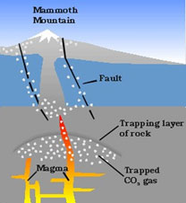
Diagram of carbon dioxide venting at faults. Reproduced from the University of Pomona, 2007.
Conclusion
Environmental Impacts
The destruction seen in the Owens River Valley is an ominous sign for the residents around Mono Lake. Before diversion of Mono Lake began in 1941, the lake level rested at approximately 6,420 feet. At its lowest point before diversion the lake fell to 6,404 feet, but diversion dropped the lake down to 6,372 feet, a near critical threshold for sustaining life since Mono Lake only grows increasing saline as the water level drops (Stine 1984). As Mono Lake fell lower and lower, the bird populations that are heavily dependent on Mono Lake as a breeding ground became endangered by predators that had access to the nesting sites by land bridges that had appeared as water disappeared. Birds have the potential to recover, however, unlike the Owens Lake which has become so arid that environmentalists have to focus on controlling the massive dust storms instead of restoring native species of plants and animals. Luckily for Mono Lake, the level of water became critical in an era when people had the power to fight a major urban bureaucracy. The dropping levels of the lake helped the California Supreme Court reach the current balance between riparian and prior appropriation rights. Unluckily for Owens Lake, however, legislation came too late and current ecologists can only hope to semi restore the destroyed valley as there is little hope for a full recovery of Owens Lake.
Potential Impacts of a Long-Term Drought
Today, California is in the middle of a three year drought which has already started raising questions about the allocation of water throughout the state. Last winter, California received a record low amount of snowfall that is critical when the snow melts to replenish the mountain streams. Due to recent legislation, riparian rights have been semi-restored which is good for Mono Lake during a drought, but not so good for the city of Los Angeles. Because riparian rights are in place, if Mono Lake falls below a certain level, which may happen this summer, diversion stops completely until the lake reaches a certain benchmark. Los Angeles already has to conserve water, so a further reduction in the amount of available water to the citizens of the city may result in an even stricter crackdown on water usage. What the future holds for the water of Los Angeles and the level of Mono Lake is yet to be determined, but will surely factor into a much larger state, or even nationwide debate about how water should be dispersed among natural and urban environments.
References
Aquafornia, 2005, Where does southern California’s water come from? Aquafornia Water Education Foundation. Retrieved from http://www.aquafornia.com/index.php/where-does-southern-californias-water-come-from/
Babb, D.E., History of early water diversions and their impact on Owens Lake. Water Usage: Sociology/Economics. City of Los Angeles Department of Water and Power.
Bailey, R.A., 1989, Geologic map of Long Valley caldera, Mono-Inyo Craters volcanic chain, and vicinity, Eastern California. U.S. Geological Survey.
Bekedam, S. (1997). Owens Valley tragedy. University of California, Irvine. Retrieved from http://darwin.bio.uci.edu
Hanak, E. and Lund, J. (2011). Floods, droughts, and lawsuits: a brief history of California’s water policy. In Managing California’s water: from conflict to reconciliation.(19-69). Public Policy Institute of California.
Jacques, H.L., 1939, Mono Craters tunnel construction problems. Journal- American Water Works Association, vol. 32, no. 1.
Sorey, M.L., Lewis, R.E., & Olmsted, F.H. (1978). The hydrothermal system of Long Valley Caldera, California. USGS Professional Paper.
Stine, S. and Friends of the Pleistocene, Pacific Cell, 1984, Holocene paleoclimatology and tephrochronology east and west of the central Sierran crest. Field Trip Guidebook for Friends of the Pleistocene, Pacific Cell.
Van Norman, H.A. (1936) The Mono Basin project: aqueduct to supply Los Angeles with Additional water now under construction in Civil Engineering. May 1936.
Wheeler, M. (2002). California Scheming. Smithsonian Magazine, October 2002.
Wyckoff, W.W. (1938). Mono Craters Tunneling has involved struggle with water and gas flows. Department of Water and Power. Los Angeles, California.
[Return to Research Projects] [Return to Sierra Home]