Geology and Natural Heritage of the Long Valley Caldera
A Land of Many Uses: Federal Land Policy in the Western United States
Kelly McCarthy
Abstract
The United States Federal government today owns approximately 650 million acres of land, much of which is located in the western United States. Management and research of the best use for federal lands has been directed by the federal government, and a policy of research and development of natural resources has dominated legislation and practice during 1800s and early 1900s. Environmental concerns, however, objected to the trend of exploitation and resource development, and by the 1960s, policy adapted, reflecting a more responsible use and management of the land’s resources, a compromise between resource development and environmental preservation. The Federal government has instead embraced a policy of "multiple uses, sustained yield." A conservationist approach which moves to utilize the Earth’s resources effectively, which ensuring a continued existence for future generations.
Expansion West and Context for Federal Land Ownership
Expansion west has defined United States society and politics since its founding. Through transactions such as the Louisiana Purchase (1803), the Adams–Onis Treaty (1819), the annexation of Texas (1845), the Treaty of Guadalupe–Hidalgo (1848), and the Alaskan Purchase (1867), the United States rapidly expanded its territory claims during the eighteenth, nineteenth, and twentieth centuries (U.S. Department of Justice, 2009). In total, the federal government owned and managed approximately 1.8 billion acres of public domain land (U.S. Department of the Interior, 2013). The intent of the government, however, was never to retain possession of this land. Initial federal land policy promoted the transfer of the public domain to private ownership. The federal government wished not only to raise revenue to pay off war debts and finance its military campaigns, but it also wanted to encourage settlement in the western territories. Some land was retained for government purposes: administrative buildings, public schools, and military use. Land was also sold or given as grants to settlers, homesteaders, veterans, local governments, colleges, universities, and private companies. The Homestead Acts, for example, allowed individuals to apply for a claim to 160 acres of land surveyed government land, at roughly $1.25 per acre. Through the Homestead Act, 80 million acres of public land were distributed by 1900 (Library of Congress, 2010). To date, the U.S. federal government has transferred nearly 1.3 billion acres of land out of its ownership (DOI, 2013).
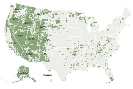
Image reproduced from The New York Times, “The Open West, Owned by the Federal Government,” 2012. Green area highlights federally owned land.
Contested Mining Rights and the Passage of the General Governing Act of 1872
The economic allure of inexpensive land and unblemished natural resources of the American West attracted thousands of pioneers to the new territories, providing a considerable boost to the government’s resettlement plan. This became especially true after the discovery of gold by James Marshall in Sutter’s Mill, California in 1848. Mining and mineral resources quickly became major industries in the western territories and states. Although it was not permitted by law, open mining on public lands was very common in the West during this time (U.S. Department of Justice, 2009). Some believed these self-proclaimed miners were little more than squatters, abusing and misusing the land, and considerable contestation concerning mining rights in public domain land developed and the debate attracted national attention (U.S. Department of Justice, 2009).
As a result, the United States Congress passed the General Mining Act in 1872. It was an act created for the development of the mining resources in the U.S., and it specifies the way in which mining claims can be made and administered on federal land. This Act governs the prospecting and mining for minerals such as gold, silver, copper, lead, zinc, and many other minerals found on public lands (Committee on Resources, 2002). This Act remains the standard for mining claims of modern day.
During this time, the Federal government recognized the need for mapping the West and surveying new lands. Little information was available for mining, extraction of mineral resources, logging, and water availability. For this purpose, Congress appropriated money for the establishment of the U.S. Geological Survey in 1879. As a branch of the Department of the Interior, the USGS was charged with the "classification of the public lands, and examination of the geological structure, mineral resources, and products of the national domain" (qtd. from Rabbitt, 2000). The original mandate of the USGS was not for pure scientific research, and the USGS was needed for the purpose of forming a standard classification of public land for recommendations for economic development and disposal to settlers (Rabbitt, 2000). USGS studies provided guidance to prospectors and investors in the West.
In order to meet the mandate to "classify the land," while avoiding overlapping duties with the General Land Office, the first Director of the USGS, Clarence King, directed the Geological Survey to produce land maps specifically for the benefit of agriculturists, miners, engineers, and economists. At that time, the future security of American currency was at risk, information about the country’s mineral wealth, mining techniques, and production capacities was inadequate, and knowledge specifically of precious metals was desperately needed (Rabbitt, 2010). As a result, the focus of the Geological Survey’s initial work emphasized geology as it related to mining. With limited funding, paleontology and topographic mapping was only valued insofar as it supported the understanding of mining and mineral resources (Rabbitt, 2010). Although King believed this type of study would tangentially benefit basic scientific study, the USGS was, since its creation, a practical tool utilized for appropriately implementing public energy policy.
In subsequent decades, considerable attention was given to the research of energy resources such as petroleum. Just as geological mapping was needed for mining resources, geological mapping for potential oil areas was pursed in areas like Wyoming, Montana, and Alaska (Rabbitt, 2010). This was information highly valued by oil companies at the time, and the Geological Survey, through its Director, became very influential in the development of a national energy policy. Similar patterns of need, research, and subsequent development followed through the war eras. For example, in the 1930s, attention was drawn to the lack of knowledge about wartime strategic minerals, and in 1939, Congress passed the Strategic Materials Act, which appropriated funds to this ends (Rabbitt, 2010). Through the War, the USGS provided strategic information to the U.S. military, further contributing to the war effort. The post-WWII industrial boom added additional incentive to Congress to continue and augment funding for the USGS.
In addition to mineral resources, water and its availability was also an area of interest for national policy and thus, the USGS. During the 1870s and 1880s, increased settlement of people in the Great Plains, and it was evident that farmers and ranchers were in fierce competition for the little water that was available. The problem was compounded by a drought in 1886, which was followed by an unusually severe winter. Almost all of the public lands were classified as "arid," defined in a 1878 report as a region where rainfall is less than 20 inches per year (Rabbitt, 2010), and according to an early report, very little of the land was suitable for conventional farming and irrigation. Early policy recommendations included changes to organization of irrigation and pasturage districts, which included suggestions for reservoirs and canals. Again, natural resources and their use was evaluated for its potential for human development. Water, like mineral resources in the area, was a commodity.
Environmental Movement and Conservation Efforts
The story of human settlement and economic policies in the American West has not been a story purely of industrial development and resource extraction. Early explorers and environmentalists successfully advocated for the establishment of Yellowstone National Park in 1872, the world’s first of its kind. A series of legislative acts that followed lay the groundwork for the national parks system that is in existence today (National Parks Service). It was not until the twentieth century, particularly during the administration of Theodore Roosevelt, that the conversationalist movement really begins to gain a national voice. Whereas previous government land management policy focused almost exclusively on the practical economic benefit of geological resources, conservationists argued for the protection of natural resources from complete extraction and depletion. A shift occurred: in the early 1900s, inventories of natural resources in official policy reports contained both estimates of resources available as well as predicted timelines for mineral resource depletion. It was not until the 1960s and 1970s, however, that this movement was able to translate its objectives into significant public policy.
In the early 1960s, the Public Land Law Review Commission (PPLRC) was directed to review existing public land laws and regulations, and in 1970, the PPLRC issued a report which contained a considerable number of legal and policy recommendations for the improvement of federal land management. First and foremost, the Commission recommended that existing federal lands should be retained as federal lands. Future disposal "should be only those lands that will achieve maximum benefit for the general public in non–Federal ownership." Federal ownership should be retained on lands "whose values must be preserved so that they may be used and enjoyed by all Americans" (One Third of the Nation’s Land: p.1.) This recommendation was quickly integrated into federal land policy. In 1972, the Federal Land Policy and Management Act was signed into law, formally ending the disposal policy of earlier years. Further disposal of public land would occur only if such a transaction would serve the "national interest" (Halden, 2011).
Wilderness
In 1964, Congress passed the Wilderness Act, which permanently classified 9.1 million acres of land as the National Wilderness Preservation System. "Wilderness," as defined by the Act is "an area where the earth and its community of life are untrammeled by man, where man himself is a visitor who does not remain" (Halden, 2011). It is an area of undeveloped federal land, now protected from commercial use and construction of permanent roads and buildings.
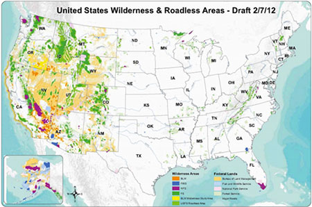
Image reproduced from Sportsmen for Public Land.
Antiquities Act
This Act was a major victory for the preservationist movement. Through its designation as "wilderness," tracts of land are protected from development and human use. Land has also been protected from development by what is known as the Antiquities Act. Passed in 1906, the Antiquities Act gives the President of the United States the power to declare public lands as national monuments, in effect protecting them from sale, leasing, or other disposition under public land laws, excluding transactions that further the protective purposes of the monument. Thirteen presidents have invoked the Act for the creation of 125 national monuments, totaling in nearly 100 million acres of land (Halden, 2011). Even though more Americans are sympathetic to protection and designation of federal land as wilderness (Rudzitis, 1991), past use of this executive authority has been met with considerable opposition. In 1996, President Bill Clinton used the Antiquities Act to create the Grand Staircase–Escalante monument in Utah, an area totally approximately 1,700,000 acres (Halden, 2011). This action was seen to target coal interests in the region. Although companies legally retained the rights to stake mining claims in the area, permits for building roads and mining facilities were almost certainly to be denied.
A Land of Many Uses
Despite these victories for the preservationist movement, the Federal government’s land policy is overwhelmingly guided by the idea that land in the public domain should be utilized in as many ways possible. The U.S. National Forest service, for example, operates under the motto, "a land of many uses," meaning management of the land should provide environmental protection, recreational services, and wood for industrial purposes (U.S. Forest Service). Both watershed protection and a sustainable supply of timber should be serviced through proper management of public lands and the national forests. Rather than remove public lands from easy accessibility in a pure preservationist mindset, the U.S. Forest Service, National Parks Service, and the Bureau of Land Management all seek a compromise between resource utilization and environmental management.
The Mono Lake Case (information from http://www.monolake.org/)
This type of compromise can be best understood through the example of the Mono Lake Case. Mono Lake, located in Mono County, California, north of the Long Valley Caldera, is a terminal basin. Like all lakes in the Great Basin hydrological region, it has no outlet to the sea. This lack of outlet has caused high levels of salts to accumulate, and a unique ecosystem as evolved, adapted to the unusual environment.
In 1941, following the early public doctrine of consumption of natural resources, the Los Angeles Department of Water and Power began diverting tributary streams from Mono Lake in order to meet the growing needs of the City of Los Angeles. Mono Lake only receives water from a few freshwater streams, snowmelt runoff, and precipitation. The rain shadow of the Sierra Nevada, however, keeps the average level of rainfall on Mono Lake at approximately 5–7 inches. Evaporation soon quickly exceeded water input. By 1962, the lake level had already dropped 25 feet.
The Mono Lake Committee, formed in 1978 in order to protect Mono Lake from irrevocable damage, successfully argued in court for the protection of Mono Lake through the Public Trust doctrine. However, the decision, was remarkably balanced. The legal resolution did not completely favor the Los Angeles DWP, nor did it accept an entirely preservationist point of view. Instead, the California Supreme Court has required the DWP to reconsider its water diversion projects in order to meet certain flow levels of water back to Mono Lake. The DWP has for this reason built aqueduct systems that only divert some water to the City of Los Angeles. Water levels in the Mono Lake tributaries (Lee Vining Creek, Walker Creek, and Parker Creek) must be continually measured to ensure proper flow levels to Mono Lake.
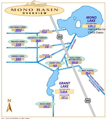
Image reproduced from www.MonoBasinResearch.org. The blue numbers on the map report real-time updates of water levels and stream flow information, data from 12 June 2013.
The system is not a perfect one, and water levels have not yet reached levels mandated by the Water Board. However, it is a compromise, and although it was litigation settled within the state of California, the Mono Lake case illustrates the broader success of the conservationist movement: wise management of natural resources for sustained production and enjoyment, today and future generations.
Resources
Committee on Resources, 107th Congress, 2nd Session. "Historical Information of the Committee on Resources and Its Predecessor Committees, 1807-2002: Preparation for a Bicentennial." U.S. Government Printing Office. Washington: November 2002.
Halden, Ann E., 2011. Forham Environmental Law Review, Volume 8, Issue 3. "The Grand Staircase–Escalante National Monument and the Antiquities Act." Accessed online: website
The Library of Congress. Homestead Act. 30 July 2010. website
National Park Service, U.S. Department of the Interior. Aug 2011. website Accessed 10 June 2013.
Mono Lake Committee. 2013. website
One Third of the Nation’s Land: A Report to the President and to the Congress by the Public Land Law Review Commission (Washington, D.C: U.S. GPO, June 1970), p.1.) Annual Review of Energy. Accessed from this website
"The Open West, Owned by the Federal Government." The New York Times, published March 23, 2012. Accessed online at this website, on 7 June 2013.
Rabbitt, Mary C., "The United States Geological Survey: 1879–1989." 2010. U.S. Geological Survey Circular 1050. website
Rudzitis, Gundars & Harley E. Johansen. How Important Is Wilderness? Results from a United States Survey, 1991. University of Idaho, Dept. of Geography. Springer-Veriag: New York Inc.
Sportsmen for Public Land. 2013. website
U.S. Department of the Interior, Bureau of Land Management. (2013). Public Land Statistics, 2012, Volume 197. BLM/OC/ST-13/002+1165: P-108-2. Accessed from this website
U.S. Department of Justice. Public Lands and National Treasures: the First 100 Years of the Environment and Natural Resources Division. 2009. Accessed from this website
U.S. Forest Service. 2013. U.S. Department of Agriculture. website
[Return to Research Projects] [Return to Sierra Home]