Geology and Natural Heritage of the Long Valley Caldera
The Geology and Biology of Mono Lake
Lucas Hatcher
Abstract
Mono Lake is an ancient saline lake 20 km east of Yosemite National Park on Highway 395 in California. It sits approximately 1945.23 meters above sea level [Mono Lake Committee website, 2013] and is 21 km long by 13 km wide [Hill, 2006]. It is considered one of the oldest lakes in North America due to the discovery of a layer of volcanic ash in the rock of one of its islands (Poaha), meaning that it dates back to at least before the Long Valley Eruption ˜760,000 years ago. Its age and the unique composition of its waters and the organisms that have adapted to live and thrive in its waters have made Mono Lake a site of vigorous conservation efforts and activism.
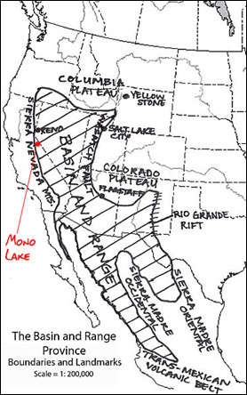
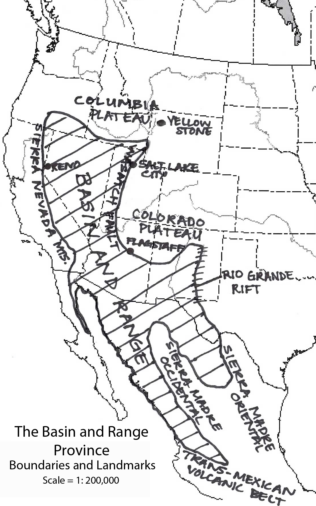
Figure 1. adapted from [Wikipedia Basin and Range Province, 2013](modified version)
Formation of the Mono Basin
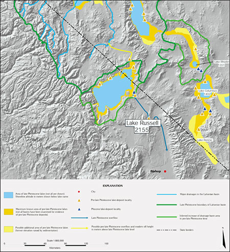
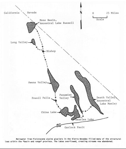
The Mono Basin began as a terminal depression that formed roughly three million years ago by the forces of faulting, in this case normal faulting, which is characteristic of the Basin and Range Province where the Mono Basin lies [Fig. 1]. As the footwall of the Sierra Nevadas got uplifted, the western side of the Mono (hanging wall) sunk and downwarped the land on the other side of the basin – this created a large bowl–like feature that could easily be filled with water. For much of the Pleistocene, the area was indeed filled and even overflowed with water due to glacial melt of the last great ice age, and, due in an even larger part, to increased precipitation. This large pluvial body of water that covered the Mono Basin was called Lake Russell and was the ancestor to what would eventually become Mono Lake. Lake Russell would reach 2200 m above sea level [Fig.2]. It covered almost 880 square kilometers and reached a depth of 270 m – over 5 times higher than modern day Mono Lake [Hill, 2006]. During this time the lake had its only outlet flowing southward, via the Owen’s River (forming the Owen’s River Gorge), into the Owen’s Lake (the lake filling Owen’s Valley), and then into a series of other ancient lakes [Fig. 3]. Ever since the ice age Lake Russell had no outlets, which led it to shrink greatly in size due to evaporation and eventually form modern day Mono Lake [Wilkerson et al., 2007].
Figure 2. adapted from [Reheis, 1999] (modified version)
Figure 3. adapted from [Wilkerson et al., 2007] (exact reproduction)
The Mono Lake Volcanic Field
Mono Lake has two islands, Paoha, which is Kuzedika (Paiute) for ’diminutive spirits having long, wavy hair’ and Negit, which is Paiute for ’goose’ Both islands are young relative to geological time. Paoha (the white island) was uplifted from the lakebed by intrusion of a rhyolitic cryptodome just 300 years ago [USGS Website, 2012] – over this time it has been subject to repeated weathering and erosion, giving it badlands topography. It is relatively large, around 9 square kilometers in area and rises about 88 m above the surface of the lake [Wikipedia Paoha Island, 2013]. Though both islands are volcanic in nature Paoha looks white because of layers of lake sediments, consisting of mostly clay, that have been accumulated on its surface. Because of this, the island may not seem to look volcanic at all but at the north and south ends of the island there are cinder cones, lava flows, and fumaroles that betray its volcanic origins. The island was named Paoha because of the foggy vapor that comes from its hot springs, vents, and fumaroles and sometimes envelopes the island, giving it a ’spirit–like’ appearance. Negit (the black island) is the more obvious volcanic feature – it was formed over numerous volcanic eruptions, the oldest being 1,700 years ago and the most recent being only 270 years ago [Hill, 2006]. Negit is smaller than Paoha and sits only 43 m above the lake’s surface [Wikipedia Negit Island, 2013].
Because of the two islands’ recent volcanic activity, much interest has gone into the lake’s potential for geothermal power. On September 13, 1971 drilling began on the south side of Mono Lake, and a month later on the northern side [Hill, 2006]. Even though this area seemed a very likely candidate, no temperatures ever exceeded 46 degrees Celsius before bedrock was hit and nothing ever became of it. This wasn’t the first time people tried to utilize Mono Lake, because during WWII Negit was used for explosives testing [Wilkerson et al., 2007]. However, humans aren’t the only animals to use the islands – their most important use is by millions of migratory birds. The birds bred on Negit because it was completely cut off from land (and therefore predators). Over the last 50 years, however, as the water level of Mono Lake has subsided, a land bridge has surfaced, connecting the island [Hill, 2006]. These, and many other reasons are why Mono Lake is a hot spot, not only for volcanic activity, but also environmental activism.
Negit and Paoha aren’t the only volcanic formations at Mono Lake. Approximately 13,500 years ago an underwater volcano called Black Point erupted. The basaltic cone cooled and contracted, creating a series of volcanic fissures at its summit that run north to south (also characteristic of the Basin and Range Province). As the lake waters subsided, the volcano became exposed and today is entirely visible and can be explored as the only previously underwater volcano in the world. It can be seen that Black Point was once underwater because of the layers of exposed ash, sediment, and tufa that lie in its fissures. These three volcanic features are considered the northernmost part of the Mono–Inyo Crater Chain, which is a 40 km stretch of volcanic features consisting of cones, craters, and domes – and are excellent examples of recent volcanic activity.
Tufa Towers
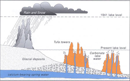
One of Mono’s most unique structures is the tufa tower. Simply put, these picturesque landforms are craggy spires of limestone that form below, and rise above the surface of Mono Lake. They form when calcium from subaqueous springs mixes with the carbonates in the water, and they react to one another to form calcium carbonate. This limestone precipitates around this spring and over time forms a tower of tufa [Fig 4]. If the tower is underwater it is safe to grow and expand, but once it comes into contact with the elements outside of the lake the tufa can grow no longer. Much of the tufa at Mono is entirely landlocked, remnants of a bygone age when the waters of the lake were much higher [Hill, 2006]. Towers aren’t the only way in which tufa forms in Mono Lake. It can also form in crystals of calcium carbonate that cover parts of the lake bottom like boulders and dead organisms, and also by biogenesis, wherein tufa grows due to the processes of animal life (alkali flies leave behind calcium carbonate as a byproduct of their pupation). One of the most interesting things about tufa is the potential secrets that it holds. Since the process of the precipitation of calcium carbonate can sometimes trap microbes, NASA scientists have studied Mono Lake’s tufa to see if perhaps it holds the clue to how they can find evidence of life on Mars (where scientists believe lakes like Mono used to exist). Mark Twain once looked at Mono’s many towers and asked, "How did they get there? I simply state the fact–for it is a fact–and leave the geological reader to crack the nut at his leisure and solve the problem after his own fashion."
Figure 4. adapted from [Wilkerson et al., 2007] (exact reproduction)
Chemical Composition
The reason this tufa exists in the way that it does is because of the unique chemical composition of Mono’s water. Mono is an alkaline lake (pH of 10) and extremely saline, this is due to the mountain streams. Mono Lake doesn’t receive much rainfall (13-18 cm) because the Sierra Nevadas block most precipitation, therefore snow melt streams have to supply it with most of its water, and these streams bring in salts and other minerals with them ’in solution.’ All mountain streams do this, however, Mono has no outlets, so therefore the only way water exits the lake is through the process of evaporation, a lot of evaporation (enough to decrease the depth of the lake 270 m since the last ice age). This process takes 4 vertical feet of water a year currently, leaving all of the salts behind [Mono Lake Committee website, 2013]. Because of this, Mono Lake is 2–3 times saltier than the ocean (280 million tons of dissolved salts) and 80 times more alkaline [Hill, 2006]. It also makes Mono 1000 times saltier than Lake Tahoe to the north. Mono is a ’triple water’ lake, meaning it has chlorides (sodium chloride), carbonates (sodium carbonate), and sulfates (sodium sulfate) – with smaller amounts of borate and potassium. While this composition is similar to other saline lakes in the area such as the Great Salt Lake and Lake Albert, they don’t have as high amounts of carbonates in them. This allows Mono’s tufa to form into towers, and gives it such a high pH, making Mono’s waters very unique [Mono Lake Committee website, 2013].
Biology
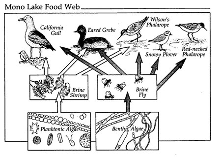
Due to its chemical composition Mono Lake can sustain no fish. Because of this, it has led many people (like Mark Twain) to believe that Mono is a lifeless, treeless, hideous desert. This is simply not the case – Mono is bursting with life. The lake is home to trillions of Brine Shrimp that erupt into streaks of color on the lake’s surface, Alkali Flies that coat the shore inches thick, and millions of migratory birds, such as the Eared Grebes, Phalaropes, and California Gulls that nest there annually. They all call Mono home for one important reason, algae. Tons of microscopic algae inhabit Mono’s waters and form the bottom of the food web there [Fig 5] and are fed on by shrimp and flies.
Brine Shrimp (Artemia monica) at Mono come in the trillions (4–6 trillion to be exact) and are a specific species of Brine that can be found in no other ecosystem except Mono Lake. The shrimp hatch from January to April and thrive in the lake during the heat of the summer. They feed off of the algae, and around June the shrimp have eaten so much of the algae that it actually makes the waters of Mono clearer and easier to see through [Hill, 2006]. But as the circle of life keeps moving, and summer turns to fall, the shrimp either die off or are eaten by birds – by wintertime Mono’s waters are entirely ’shrimpless’ (except for the small shrimp ’cysts’ that the female shrimp lay on the bottom of the lake to hatch during the spring) [Mono Lake Committee website, 2013]. Without the shrimp to feed on them, the algae ’bloom’ and repopulate, becoming so great in numbers that it turns the waters green and the cycle of life at Mono begins again [Hill, 2006].
Alkali Flies (Ephydra hians) begin their life underwater. First as larvae, then as a pupal, and finally the fly emerges, as a small sac of air bursts out of its head and breaks its casing. The fly then surfaces from the casing and reassembles its head back together on shore, ready to begin adult life. The flies can return underwater anytime and have to do so to feed on algae and lay their eggs. They have small hairs on their body that can trap a thin layer of air for the fly to breathe which allows them to survive under the water. They are such a significant staple to the Mono food web that the entire area is named after them. ’Mono’ is a local Native American tribe’s nickname for the Kuzedika, meaning, ’fly eater.’ The Natives would begin the summer with a harvest of the fly pupae in the shallow water – they would dry them, take their shell off, and eat them. High in calories the Kuzedika ate enough of the flies to garner the name ’Mono’ [Mono Lake Committee website, 2013].
Birds, Mono Lake has a lot of them. In fact over 300 species of birds show up at Mono yearly, and they are on top of Mono’s food web [Fig 5]. The main reason is that the flies and shrimp are in such abundance that it can feed millions, and indeed it does. The three main birds that employ Mono’s waters are the California Gull, the Phalarope, and the Eared Grebe. The California Gulls (Larus californicus) that live their lives in California (as opposed to Utah) are almost all born at Mono Lake (as opposed to the Great Salt Lake). By May somewhere between 44,000 and 65,000 gulls return to Mono to feed and to breed [Mono Lake Committee website, 2013]. Some 30,000 gulls used to nest at Negit Island (as previously discussed) because of its safety from predators like coyotes. They have been unable to do so in recent time because of the formation of a land bridge to the island in 1979 due to lowering water levels, and while Mono’s waters are on the rise, only a fraction of those gulls have been able to return [Hite, 1999]. Instead the gulls use tiny inlets that are close to the island but force them to live in much greater density. The second bird is the Phalarope, in this case the Wilson’s Phalarope (Phalaropus tricolor). Unlike the gulls, these Phalaropes do not breed at Mono – they do their breeding on the coasts of Washington and British Columbia. Mono Lake is an important stop for them on their nearly 5,000 km journey down to South America. They appear at Mono around July and spend a few weeks feeding on the shrimp and flies (effectively doubling their weight) and molting. By September they all leave Mono full of energy and ready for their journey ahead. Arguably the most important bird in the Mono ecosystem is the Eared Grebe (Podiceps nigricollis). Like the Phalaropes the Grebes breed in Southern Canada and make their way to Mono in late summer as a pit stop to eat and molt for their migration south. They come to Mono in the millions (1.5–1.8) and nearly triple their weight diving in the water and feasting on the abundant shrimp. They can compress their feathers and their organs in order to decrease their buoyancy allowing them to sink under the water to avoid predators and to feed. Their bodies are extremely adapted for swimming, with a slim physique and dense bones to help them dive – their feet are lobed and their legs are pushed back to help propel them through the water. Because of this the Eared Grebe has to spend its entire life on water and will only fly when it has to (its wings and tail are undersized). If it ends up on land it is so unable to walk that it will usually die. Luckily for them, Mono provides sufficient water and excess food, so much food some leave Mono too large to fly and have to slim down before withdrawing to Mexico for winter. Mono Lake is an important environment for millions of birds, with almost 100 birds nesting around its waters every year [Mono Lake Committee website, 2013].
.Figure 5. adapted from [Botkin et al., 1988] exact reproduction
Environmental Activism
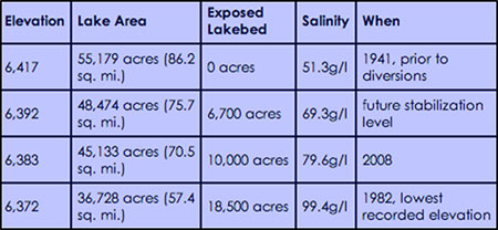
In 1941 Mono began its story of environmental activism. To meet the needs of a growing city, the Los Angeles Department of Water and Power began to divert 4 of the 5 streams that provided Mono its waters and by 1962 the depth of Mono had dropped by half [Mono Lake Committee website, 2013]. The chemical composition of Mono is very particular and fragile and is an important factor in the lives of the organisms that call Mono home. As the depth of Mono Lake changed, the concentration of the important ions in the lake also changed and effected the ’osmotic environment’ [Patten et al., 1987]. This change in the osmotic environment reduced the rate of photosynthesis of the algae, made it difficult for the Brine Shrimp to reproduce, and caused dust storms to begin cropping up due to exposed lakebed. If left to continue Mono would have ended up like Panamint Lake before it, which was a saline lake similar to Mono and now is nothing but a dried up lakebed, and a host to toxic dust storms. Horrified by this prospect a man by the name of David Gaines formed the Mono Lake Committee in 1978 to protect Mono Lake and its inhabitants. By taking on the LADPW and by reducing the amount of water taken from Mono’s tributaries, the Mono Lake Committee not only brought the depth back up to a healthy level [Fig 6], but also was also able to continue allowing Los Angeles to receive water from the Sierran mountain streams.
Figure 6. adapted from [Mono Lake Committee website, 2013] exact reproduction
Conclusion
Mono Lake is very important piece of geological history and ecological present. It is one of the few ancient saline lakes still in existence, it is a prime example of recent volcanic activity (and underwater volcanic activity), it has a unique chemical composition, and tufa that grows like nowhere else on earth – but most of all it has a flourishing ecosystem that was once threatened by the hands of men. Now Mono is safe, protected for our benefit, and for the future benefit of everyone, not just in the Mono Basin, but everywhere.
Works Cited
Hill, Mary. Geology of the Sierra Nevada. Berkeley: University of California Press, 2006.
Wilkerson et al., Roadside Geology and Mining History: Owens Valley and Mono Basin. Bakersfield: Buena Vista Museum of Natural History, 2007.
Patten et al., The Mono Basin Ecosystem: Effects of Changing Lake Level. Washington, D.C.: National Academy Press, 1987.
USGS. "Mono Lake Volcanic Field." Last modified May 23, 2012. website
Mono Lake Committee. "Brine Shrimp: Mono Lake’s Unique Species." Accessed June 6, 2013. website
Mono Lake Committee. "Mono’s Alkali Fly: The First Fly You’ll Ever Love." Accessed June 6, 2013. website
Mono Lake Committee. "Birds of the Basin: The Migratory Millions of Mono." Accessed June 6, 2013. website
Mono Lake Committee. "Quick Facts." Accessed June 3, 2013. website
Wikipedia. "Paoha Island." Accessed June 4, 2013. website
Wikipedia. "Negit Island." Accessed June 4, 2013. website
Hite, Justin. "The Awesome California Gull: Mono’s Unlikely Mountaineer." Water Matters. Accessed June 7, 2013. website
Mono Lake Committee. "Eared Grebe at Mono Lake." Accessed June 7, 2013. website
Washington State University. "The Mono Lake Food Web." Accessed June 6, 2013. website
Wikipedia. "Basin and Range Province." Accessed June 3, 2013. website
[Return to Research Projects] [Return to Sierra Home]