Geology and Natural Heritage of the Long Valley Caldera
Geological Constraints on High–Level Nuclear Waste Disposal and their Relationship to Possible Long Term Storage Solutions – A Case Study of the Yucca Mountain Project
Teresa Dunn
Abstract
Since the development and utilization of nuclear energy during World War II, the United States has struggled with the issue of disposing of high–level nuclear waste. A danger to the environment and human health, this waste has increased in quantity with the widespread production and use of commercial nuclear energy. The U.S. government has recognized geologic disposal as a solution since the mid-1950s, and chose a single repository site in 1987– Yucca Mountain, Nevada. However, geologic constraints such as properties of composition, hydrologic systems, seismic activity, and volcanism created debate in both the scientific and political community, and Yucca Mountain, to date, has never been utilized. This report explores the relationship between the geological setting of the Yucca Mountain Project and the scientific requirements for secure confinement of high–level nuclear waste- primarily, the importance of hydrologic systems and geologic composition in the selection and development of a secure, long–term storage facility.
Introduction
According to the U.S. Energy Information Administration (or EIA), there are a total of 104 operable nuclear generating units in the United States, as of February 20131. This relatively small number of plants produces about 20% of the United States’ total energy consumption [EPA website, Nuclear Energy, 2013]. Although nuclear energy is considered a "clean" energy– largely because of its lack of direct harmful air, water or ground contamination and its absence of direct use of fossil fuels– it produces waste that is extremely harmful to the environment
1 "Nuclear generating units" defined as those units which hold "full–power licenses, or equivalent permission to operate, at end of period." [U.S. EIA, 2013]
There are three types of radioactive waste associated with the use of nuclear substances and energy. They are characterized by the level of radioactivity of the substance and its corresponding risk to the environment– classified as low–level, intermediate–level, or high–level waste. Low–level waste is produced from everyday use of radioactive substances or nuclear energy, such as in hospitals or industry. It has an extremely short–lived radioactivity, and is approved for shallow land burial. Intermediate–level waste usually contains fission products, chemical "sludge" and contaminated materials from reactors. It contains higher levels of radiation and requires a small–to–moderate amount of shielding. It is usually disposed of by solidifying the waste in concrete [World Nuclear Association website, 2012].
Understandably, high–level nuclear waste has the highest amount of radiation, and therefore presents the highest risk to the environment and human health. This waste requires cooling and a high amount of shielding, in order to minimize those risks. High–level waste (or HLW) accounts for, on average, over 95% of the total radioactivity produced in the process of electricity generation by nuclear fission [World Nuclear Association website, 2012]. Nuclear waste categorized as high–level is primarily "spent" fuel used to produce nuclear energy; contaminated materials from reactors can be classified as HLW as well, however this makes up an almost negligible amount of the total waste produced and is not related to this research, and is therefore disregarded for the purpose of this report. These fuel cells are made up of concentrated uranium oxide pellets. During the fission process the stable uranium atom becomes radioactive, due to changes in the relationship between the atomic nucleus and its electron clouds as a result of the massive release of energy as the uranium atom is split into two. After all its energy is released, the uranium fuel cells are considered waste [Gosline, 2013].
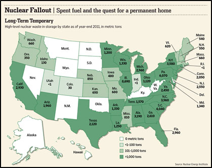
When HLW (in the form of spent fuel) is removed from reactors, it is isolated from the environment in order to prevent environmental damage and human contact. The fuel rods are stored in racks that are then placed in deep pools, which also give the added benefit of allowing the rods to cool. These storage facilities are located on–site at nuclear reactors around the country (Figure 1); however, they are not designed for long–term use [U.S. NRC, 1996]. Because of these substances’ extremely high level of radioactivity, any repository meant for long–term storage of nuclear waste would have to be able to ensure the waste’s isolation for the maximum amount of time it would take for that waste to decay to a point at which it was safe to be exposed to the biosphere. This is called its half–life; that is, how long it takes for half of a sample to undergo radioactive decay, therefore rendering it harmless to the environment.
Figure 1: High–level nuclear waste temporary storage by state. Figure reproduced from Johnson [2013]
By the early 1980s, with nuclear energy and technology rapidly developing across the world, the problem of nuclear waste disposal became an extremely pressing political and scientific issue. This problem was recognized by the US Government, and in 1982 the Nuclear Waste Policy Act (or NWPA) was passed. This Act formally established geological disposal as the best long–term solution for the disposal of high–level nuclear waste and created requirements and guidelines for the Department of Energy to research, develop, approve and implement a long–term geologic solution at one of multiple sites considered [NWPA, 1982].
In fact, according to a 2011 report prepared for the U.S. Department of Energy (or DOA), geologic disposal has been the "recommended option" for permanent disposal of spent nuclear fuel and high–level waste in the United States since 1957, when the National Academy of Sciences (or NAS) published a report on the subject. This position has been reaffirmed many times since, by the NAS itself (most recently, in 2001) as well as the DOA, the NRC, etc. [Rechard et al., 2011] Although there are other alternative options for disposal which have been proposed, for the purpose of this report they are disregarded.
In 1987, the United States Congress designated Yucca Mountain as the primary nuclear waste disposal site for the U.S. Energy program. However, with escalating political and scientific debate continuously delaying and halting the project, the Obama Administration shut down the Yucca Mountain site in 2010, before any repository could be finished or tested. [Johnson, 2013].
Geologic Criteria
Following the passing of the NWPA in 1982, the United States Geological Survey (USGS) performed research in 8 states (including Oregon, Idaho, California, Nevada, Utah, Arizona, New Mexico, and Texas) in order to evaluate favorability for waste disposal. The USGS studied a variety of features of each site, including geological content, hydrological systems and tectonic environment. Specifically, the USGS studied the amount of potential host rocks on the surface of the site, Quaternary faulting and volcanism, seismic activity, vertical movement, water table level, groundwater flow units and contours, Pleistocene water bodies and mineral and energy resources [Dinwiddie and Trask, 1986]. When comparing the research done by USGS and that of the National Research Council, it is clear that the USGS largely based their evaluation off of geologic criteria for nuclear waste repository sites developed by the National Research Council in 1978. Included in these criteria were specific depth requirements, a clear emphasis on the stability of the rock formations within the region, a lack of active faulting, geothermal activity and volcanism and the provision of significant sorption and lack of vulnerability to dissolution within the rock [Long and Ewing, 2004]. In 1980, the Department of Energy listed salt, granite, shale and basalt as "examples of repository host rock" in which a radioactive waste disposal system would be considered. Volcanic tuff was also mentioned as a possible candidate. In the same report, the DOA discussed the use of a multiple–barrier system, both engineered and geologic barriers designed to minimize the risk of exposure of the waste to the surrounding environment [U.S. DOA, Management, 1980]. It is necessary to point out, however, that the use of multiple barriers (both engineered and geologic) in order to prevent the exposure of radioactive waste to the biosphere creates an even larger range of possible geologic materials to consider. [Rechard et al., 2011].
In 1986, using this research and criteria, the Department of Energy selected three "finalists" to be considered, by Congress, for a nuclear waste repository. These sites were Hanford, Washington; Deaf Smith County, Texas; and Yucca Mountain, Nevada. A year later, Congress designated Yucca Mountain as the only site for further consideration [Johnson, 2013].
Yucca Mountain Project
Physiographic and Geologic Setting
Yucca Mountain is located in the southwest region of Nevada, about 100 km north of Las Vegas. The site is within the boundary of a larger piece of land used by the U.S. government for nuclear weapons testing in the mid–to–late 20th century, known as the Nevada Test Site. This region is a small part of the Basin and Range Province, which is characterized by internal water drainage. This means that the water within this region does not drain to the ocean, as does most water in the hydrologic cycle on Earth – it drains internally.
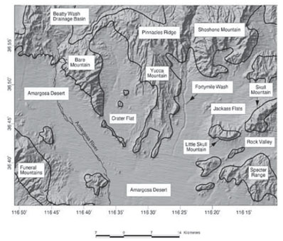
The lowest elevation at the site can be found in the lowlands east and west of Yucca Mountain, which range in elevation from around 850 to 1000 meters above sea level. The highest point, the crest of Yucca Mountain, rises to around 1930 meters above sea level [Stuckless and O’Leary, 2007]. As in most arid climates, surface water runoff is ephemeral in the region, and at Yucca Mountain runs primarily through Fortymile Canyon and south through Fortymile Wash (Figure 2). Drainage from Jackass flats to the east also flows into the Fortymile Wash, which in turn runs into the Armargosa River about 15 kilometers southwest of the site [Stuckless and O’Leary, 2007]. However, a drilling program developed by the USGS in order to study possible sites for HLW repository found differences in water table elevations which suggested that the fault of Solitario Canyon just west of Yucca Mountain was retarding the eastward movement of groundwater. Chemical analyses performed in this same study revealed that the most abundant ions in the groundwater were sodium and bicarbonate [Dinwiddie and Trash, 1986].
The Yucca Mountain site has a thick unsaturated zone (490–760 m), which is common in arid environments, as the groundwater table is generally very low [Dinwiddie and Trask, 1986].
Figure 2: Geography of the Yucca Mountain site and vicinity (the boundary of which is characterized by the San Andreas Fault in California). Figure reproduced from Stuckless and O’Leary [2007].
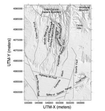
The Basin and Range Province also has a north–south trend of normal faults, formed by the tectonic extension of the region as a result of the strike–slip fault boundary between the Pacific Plate and the North American Plate. As the plates grind against each other, the North American plate is pulled by the Pacific plate in a general north–west direction. This pattern is consistent in the Yucca Mountain site and vicinity, which has a number of north-south trending fault ridges (Figure 3)2, two of which bound the repository site– Solitario Canyon Fault to the west and Bow Ridge fault to the east, and three of which lie within the actual site (the Ghost Dance, Sundance and Drill Hole faults). These faults are considered active, as the region is still being altered by the modern–day movement of the plates. Seismically, this translates to an active tectonic environment that has produced earthquakes as large as 5.6 on the Richter magnitude scale (June 29, 1992 at Little Skull Mountain, about 12 miles from Yucca Mountain) [Long and Ewing, 2004].
Bedrock in and around Yucca Mountain is comprised primarily of ancient ash fall overlying Paleozoic carbonate pre–Tertiary basement rock, which has a depth ranging from 1,250 to 1,830 meters [Dinwiddie and Trask, 1986]. The ash, deposited by a volcanic eruption between 11 and 14 million years ago, cooled and hardened into a rock type known as "tuff." This volcanic tuff is extremely fractured as a result of the cooling process. The amount of fracturing in specific sections (or "beds") of rock depends on the speed of cooling, as well as details of deposition and geologic history. Generally, the tuff is either welded (highly consolidated as a result of the rapid introduction of high–silica lava flow to the ash fall) or non–welded (loosely consolidated). Welded tuffs tend to have more fractures and are more brittle than nonwelded tuffs, which also contain more zeolites (complex minerals known for their ability to sorb metals). Both types of tuff have extremely low matrix permeability (around 10-18 m2 – 10-13 m2), with a much higher secondary permeability (owing to fractures and faults) [Long and Ewing, 2004].
Figure 3: Tectonic features of Yucca Mountain and vicinity. Figure reproduced from Long and Ewing [2004]
2 This detailed mapping of fracture patterns and tectonic features at the Yucca Mountain site was first done by the USGS in the early 1980s, as research performed in accordance to the guidelines of the Nuclear Waste Policy Act of 1982. In fact, this mapping and characterization was the first time that fracture trace patterns for two-dimensional slices (taken from exposed rock pavements near the Yucca Mountain site) were quantified, using fractal geometry, through a three-dimensional fracture network.
Silicic volcanism has occurred in the Yucca Mountain area for over 8 million years, primarily at the Timber Mountain caldera complex to the north of Yucca Mountain [Fabbro, 2010]. Since then, basaltic volcanism has occurred in three "peaks" of volcanic activity, the most recent being approximately one million years ago. Although the region is currently in a fairly inactive period, there have been three episodes of small–volume volcanism in the last 80,000 years, within 80 kilometers of Yucca Mountain [Long and Ewing, 2004].
Repository Specifications
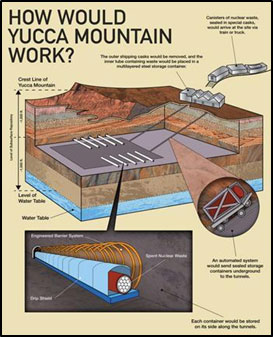
Figure 4: Diagram of proposed Yucca Mountain repository. Figure reproduced from Gosline [2013].
In their Final Environmental Assessment of the Yucca Mountain Site in 1986, the DOA detailed the specifications for a geologic repository at the site (Figure 4). The concept is very similar to a large underground mine occupying about 2,000 acres at a depth between 300 to 1,000 meters (or between 1,000 to 4,000 feet). This would place it in the unsaturated zone of the region, 200 to 400 meters (656 to 1,300 feet) above the water table [Fabbro, 2010]. Surface facilities were to be developed at the site to handle the waste when it was first received for disposal, which would occupy about 400 acres. The site would be "active" (receiving and actively moving waste) for around 30 years, at which time the repository would be sealed and full waste isolation would be achieved. Multiple barriers would be utilized to ensure the isolation of the waste, including natural barriers (geologic, hydrologic and geochemical environments of the site) as well as engineered. These man–made barriers would consist of the waste package itself and the underground facility.
The "waste package" included the waste form and waste disposal container, as well as materials placed over and around the containers. These materials included a titanium "drip shield," which would provide another layer of protection from hydrologic seepage [DOA, Recommendation by the Secretary of Energy, 2002]. The underground facility would consist of underground tunnels and backfill materials.
As per requirement under the Nuclear Waste Policy Act of 1982, as well as the Energy Policy Act of 1992, the EPA set specific standards for the length of time a long–term HLW repository site would have to remain geologically stable in order to protect the waste from exposure, until the waste reached a level of radioactivity which would be considered harmless to the environment and public health. Originally, this standard was set at 10,000 years; however, in July 2004 the US Court of Appeals for the District of Columbia Circuit ruled that the standards must be amended as they apply specifically to Yucca Mountain. The new standards extended coverage beyond 10,000 years to 1 million years and established a dose rate limit for the post–10,000 year period (decided as 100 mrem/year) [EPA website, About Yucca Mountain Standards, 2012].
Analysis
Geologic Composition
Both the welded and nonwelded tuffs that make up the majority of Yucca Mountain’s geologic composition present distinct advantages and disadvantages to the construction and utilization of a HLW repository at this site. In this case, both types of tuff have low matrix permeability [Long and Ewing, 2004], which would prevent a large amount of permantation of leaked radionuclides into the rock, and eventually to the ground water below. However, its secondary permeability, which is significantly higher in both the welded and nonwelded tuffs [Long and Ewing, 2004], presents a problem. This permeability is significantly higher, as mentioned above in the discussion of physiographic and geologic setting in Yucca Mountain, because of the fractures that exist within the tuff. These fractures serve as pathways for surface and ground water seepage to travel through the rock, making the risk for radiation contamination and eventual ground–water dispersal higher. A more attractive feature of the tuff, however, is its ability to trap radionuclides through sorption. The presence of complex minerals known as zeolites in the tuff causes the rock to absorb a variety of metals when exposed– most notably, certain radionuclides that are found in spent fuel cells. This would mean that the rock surrounding the Yucca Mountain site could, in theory, absorb some of the contamination if exposure occurred [Fabbro, 2010]. However, this would depend on the location of nonwelded tuff beds, as zeolites are much more present in nonwelded tuff [Long and Ewing, 2004]. Therefore, nonwelded tuff would serve as a much more successful barrier to radionuclide transport, compared to welded tuff.
Hydrology
The thick unsaturated zone at Yucca Mountain is a simple but important factor in its predicted success as a HLW repository site– a thick unsaturated zone translates to a very low water table, which can minimize the risk of hydrologic contamination. And because the repository is 200 to 300 m above the already low water table [Stuckless and O’Leary, 2007], it can be reasonably assumed that the most likely cause of hydrologic contamination would be infiltration of surface water. However, Yucca Mountain only receives an annual precipitation of around 150 millimeters (5.91 inches). Because of the extremely arid climate, most of this water is returned to the atmosphere through evaporation before it can infiltrate deep enough into the rock to reach the level of the repository, and eventually the water table. In fact, only about 3 percent or less of the annual precipitation in the region reaches the depth proposed for the repository [DOA, Final Environmental Assessment, 1986]. This drainage pattern was established soon after the volcanic activity that deposited the tuff that formed this area, and the overall system has changed little since then [Stuckless and O’Leary, 2007]. However, it is worth considering that future climatic uncertainties (primarily those concerned with extreme climates, such as the Yucca Mountain site) may cause this pattern to drastically change [Fabbro, 2010].
Erosion
Erosion is a very small risk in this specific case. Although calculations have been performed, the time period at which erosion would reach the repository is extremely broad (between 500,000 and 5 million years) [Fabbro, 2010]. While climatic and hydrologic changes could cause erosion to become a much more significant issue in the distant future, its risk is small enough (compared to other risks presented at this site) to disregard.
Earthquakes
When considering the risk of seismic activity and earthquakes at and around the Yucca Mountain site, there are two time periods of interest– the "pre–closure" period (defined as 300 years) and the "post–closure" period (of 10,000 – 1 million years). While there is a precedent for considering seismic risks during the pre–closure period (which is roughly equivalent to time periods considered in other critical structures), the prediction of risk over the post–closure period has no precedent [Long and Ewing, 2004]. Therefore, while it is possible to predict seismic activity in the area within the pre–closure period, it is extremely difficult (if not impossible) to predict seismic activity at any possible site for the time period of post–closure. This is especially difficult at a site at which seismic activity has occurred for a long period of time: while it is quite reasonable to assume that activity will exist, it is difficult to predict when, where, and at what magnitude.
The most distinct danger when considering earthquakes is not direct damage– once again, it is an issue of fracturing and faulting in the rock. Both smaller–scale fracturing and large–scale faulting create significant new space in the rock in a number of ways– openings at the edge of faults or in areas perpendicular to the seismic movement; dilation of faults, causing large increases in secondary permeability; and many other possible movements associated with seismic activity [Long and Ewing, 2004].
Direct damage is not a significant risk because of the repository’s ability to move with the rock. Damage to the repository is a risk; however, this risk is usually associated with a "direct hit" – a large earthquake occurring at the site of the repository – and the statistical chances of that are extremely slim, making the risk relatively insignificant [Fabbro, 2010].
Volcanism
The U.S. Department of Energy’s analysis of risks of radioactive releases during the 10,000–year compliance period (prior to the EPA’s extension of the period) found that the risks of contamination are relatively small. While this analysis comes with a recognizable amount of bias, it is curious to note that these risks (while small) are dominated by volcanism [Long and Ewing, 2004]. These future volcanic risks are estimated from geologic records of paleovolcanism in the Yucca Mountain area. Because of its large amount of volcanic activity in the recent geologic past, the risk of contamination as a result of volcanic activity is extremely high at the Yucca Mountain site, especially when compared to other, non–volcanic sites. However, it seems that this method of prediction would also come with a larger amount of uncertainty than normal, as the Yucca Mountain site lies on the borders of three different tectonic domains– the Basin and Range, Walker Lane, and Inyo–Mono domains [Stuckless and O’Leary, 2007]. These three domains are all tectonically and volcanically active in recent geologic history, however, which presents a greater risk for volcanism.
An eruption near the repository presents two main risks. In terms of direct alteration, both basaltic and explosive pyroclastic flow could infiltrate the repository as magma (pre–eruption) and subsequently erupt through repository tunnels, carrying HLW into the biosphere and (in the case of pyroclastic flow) into the atmosphere. Indirectly, hydrothermal circulation resulting from active volcanism in the area could increase the speed of corrosion of engineered barriers and absorption of radionuclides into the ground water, therefore increasing the amount and speed of contamination [Fabbro, 2010].
Conclusions
It is clear that, although there are a number of geologic constraints on long–term solutions for nuclear HLW disposal– including geologic composition, hydrologic interaction, seismic activity, erosion, and volcanism– even in extremely arid climates such as the Yucca Mountain site, hydrologic interaction is the most prevalent. It is the primary mechanism of which contamination can occur, and is the most prevalent consequence to other risks discussed.
In terms of the Yucca Mountain Project as a case study, it is clear that geologically, the area’s hydrologic setting was its most attractive feature, and therefore a large part of the deciding factor in choosing this site. While there are a significant number of risks (such as volcanism), the area’s hydrologic system (as well as the geologic compositional features such as low permeability and sorption ability) clearly placed this site ahead of all others considered.
Weighing the risks in this case is difficult. While the advantages of the geologic and hydrologic environment are definite, the risks (while extremely significant) are uncertain. The very active presence of volcanism in the area makes these risks more definitive; however when weighed against the presence of over–crowded short–term storage facilities across the country, it becomes a question of long–term versus short–term safety, and the probability of finding another possible long–term storage site in the near future. The decision seems to have already been made. After decades of political and scientific debate, the Yucca Mountain Project was formally halted in 2010, when the Obama Administration stated that the Energy Department would stop seeking Nuclear Regulatory Commission licenses for the project [Johnson, 2013]. Therefore, the site was never constructed or utilized as a waste repository. This makes the applicability of Yucca Mountain as a case study even more powerful– not only does it exemplify the geologic constraints of long–term HLW repository research; it encompasses the much more complex environment that exists when policy and science meet.
Resources
May 2013 Monthly Energy Review. Rep. no. DOE/EIA-0035(2013/05). U.S. Energy Information Administration, 28 May 2013.
"Nuclear Energy." EPA. 30 Apr. 2013. Environmental Protection Agency, website
"Radioactive Waste Management." World Nuclear Association. Apr. 2012. website
Gosline, Jeanie E. "The Problem with Yucca Mountain." State & Local Energy Report. 21 May 2013. website
Generic Environmental Impact Statement for License Renewal of Nuclear Plants: Main Report. Rep. no. NUREG-1437. Vol. 1. Washington, DC.: U.S. Nuclear Regulatory Commission, May 1996.
Nuclear Waste Policy Act of 1982. 96 Statutes at large 2201, 42 U.S. Code 10101 et seq.
Rechard, Rob P., Barry Goldstein, Larry H. Brush, James A. Blink, Mark Sutton, and Frank V. Perry. Basis for Identification of Disposal Options for Research and Development for Spent Nuclear Fuel and High–Level Waste. Rep. no. FCRD-USED-2011-000071. U.S. Department of Energy, March 2011.
Johnson, Keith. "How Should We Deal With Nuclear Waste?" The Wall Street Journal. 11 Apr. 2013. website
Long, Jane C.S., and Rodney C. Ewing. Yucca Mountain: Earth–Science Issues at a Geologic Repository for High–Level Nuclear Waste. Rep. no. 32:363–401. Annual Reviews, March 2004.
Final Environmental Impact Statement: Management of Commercially Generated Radioactive Waste. Rep. no. DOE/EIS-0046F. Vol. 1. U.S. Department of Energy, October 1980.
Stuckless, J.S. and O’Leary, D.W., 2007, Geology of the Yucca Mountain region, in Stuckless, J.S. and Levich, R.A., eds, The Geology and Climatology of Yucca Mountain and Vicinity, Southern Nevada and California: Geological Society of America Memoir 199, p. 9-52, doi: 10.1130/2007.1199(02).
Dinwiddie, G.A., and N.J. Trask. U.S. Geological Survey Research in Radioactive Waste Disposal – Fiscal Years 1983, 1984 and 1985. Rep. no. Water–Resources Investigations Report 87–4009. U.S. Geological Survey, 1986.
Fabbro, Gareth. "Nuclear Waste – A Geologist’s Perspective." Science 2.0. 10 Sept. 2010. website
Final Environmental Assessment: Yucca Mountain Site, Nevada Research and Development Area, Nevada. Rep. no. DOE/RW-0073. Vol. 1. U.S. Department of Energy, May 1986.
Recommendation by the Secretary of Energy Regarding the Suitability of the Yucca Mountain Site for a Repository Under the Nuclear Waste Policy Act of 1982. Recommendation Report. U.S. Department of Energy/Secretary of Energy Spencer Abraham, February 2002.
"About Yucca Mountain Standards." EPA. 30 Aug. 2012. Environmental Protection Agency. 12 June 2013. website
[Return to Research Projects] [Return to Sierra Home]