Geology and Natural Heritage of the Long Valley Caldera
The Geology and History of the Bodie Mining District
Jacob van Wesenbeeck
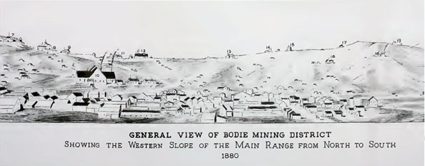
Figure reproduced from Chesterman et al., 1986
Figure reproduced from Michael Hamburger, website
Abstract
The Bodie mining district, in Mono County, California, is the site of a historical gold mining operation. A magma source underground and a series of faults allowed a hydrothermal system to develop in which water was heated underground and forced to the surface, where it deposited minerals, including silver and gold in quartz veins. These veins were mined and the ore milled and smelted into gold bars locally in Bodie between the 1840s and 1950s, when it was abandoned. The town of Bodie, including a stamp mill, has been a preserved ghost town since 1956.
Introduction to Gold
Gold has been used in jewelry since prehistoric times; jewelry and currency were its only uses until the 1900s, when several industrial uses were discovered, such as in architectural glass, circuits, radioisotope medicine, and radiation shielding in space craft (Butterman and Amey, 2005). Even today, 3/4 of the gold supplied each year is made into jewelry (Butterman and Amey, 2005). Gold was used as currency as early as 6000 years ago in Egypt, and as a standard to back symbolic or paper currency between the 1700s and the 1970s, when the United States and the IMF untied currency from gold (Butterman and Amey, 2005). Gold is extremely valuable; despite a recent plunge in gold prices, they remain at $1560 USD/ounce (La Monica, 2012).
Humanity’s insatiable quest for gold continued in California beginning in 1848 when gold nuggets were discovered near Sacramento, California (California Resources Agency website). The news of the discovery brought half a million people to California in search of gold, in what is termed the Gold Rush (California Resources Agency website). The gold deposit of Bodie, California was discovered during this period (Chesterman et al., 1986).
History of the Bodie Mining District
The Bodie Mining District is an area in northern Mono County, California, north of Mono Lake, extending approximately 3 miles north–south and 1 mile east–west (Chesterman et al., 1986). Gold was first discovered there in 1859 in placer deposits, sedimentary structures where denser particles are concentrated at a low point in a stream; the same year, gold–bearing veins of quartz were discovered (Chesterman et al., 1986). The Standard Mining Company began mining in 1877 and the following year struck a rich vein which sparked a 10 year long boom (Chesterman et al., 1986). The ore was milled locally within the district (Chesterman et al., 1986). Following the boom, which ended in the late 1880s, mining continued until 1915 and then sporadically into the 1950s (Chesterman et al., 1986). Approximately 1.5 million ounces of gold were mined from the district (Herrera et al., 1993). The town of Bodie has been preserved as a State Park since 1956 (Chesterman et al., 1986). Recent surges in the past few years in the price of gold have rekindled interest in mining the Bodie district, which hasn’t been mined since the 1950s (Scheck, 2011).
Milling in the Bodie Mining District
Eight mills operated in the Bodie district by the 1880s (Chesterman et al., 1986); one such (abandoned) mill was visited by the author. Gold ore was carried up from the mine in buckets, it was then placed on a conveyor belt and carried into the mill. Ore pieces less than approximately 5 cm passed through, while larger pieces were sent to the crusher to be broken up. The smaller pieces continued to the stamps, originally steam-powered, then hydroelectrically powered. The stamps were made of very heavy steel cylinders which were lifted about a meter by a rotating cam shaft and then allowed to drop down onto a pile of ore about once per second, pulverizing the ore to a fine powder. The powder was then mixed with water and run down an amalgamation table of copper coated in a mercury solution. The gold would bind to the mercury and remain on the table, while the waste rock would simply flow off the edge of the table. A secondary gold recovery method was a shake table: a fine mesh table which was slightly tilted and then vibrated, so that the denser gold and silver would move to the lower end and leave the less dense waste rock behind. The gold was then heated until the mercury evaporated (the mercury would be condensed and recycled), then melted and forged into gold bars. Some gold was still contained in the waste rock, however, and when the cyanidation process was discovered around the early 1900s, it was applied to the waste rock in the talus heaps. The rock was dissolved in a cyanide solution and the gold bonded to the cyanide and was then separated from the waste solution.
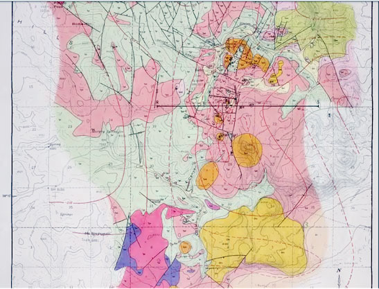
Figures 1 and 2: Geologic map and legend showing area from Bodie Bluff to Sugarloaf. Figures reproduced from Chesterman et al., 1986.
Host Rock Geology of the Bodie Mining District
The bedrock of the district is formed of pre-Cretaceous granitic rock intruding into gneiss and schist (Chesterman et al., 1986). That rock is overlain by tertiary volcanic rocks, including tuff, lava flows, and plugs, most of dacitic composition, but some of rhyolitic, andesitic, and basaltic compositions (Chesterman et al., 1986). The age of these volcanic rocks ranges from 13.3 to 5.7 Ma (Herrera et al., 1993). Figures 1 and 2 show these young volcanic rocks. The vast majority of gold recovered occurs in the plug around Bodie Bluff and Standard Hill (Chesterman et al., 1986), colored orange (dacite plug, 8.2 – 8.7 Ma) in Figure 1.
The volcanic rocks of the district are divided into three units: the Potato Peak Formation, Murphy Spring Tuff Breccia, and the Silver Hill Volcanic Series (Chesterman et al., 1986). The Potato Peak Formation crops out in the northwest of the district and is comprised of dacite flows layered with dacitic tuff breccia approximately 9.1 to 8.4 Ma in age (Chesterman et al., 1986). The combined thickness of the dacite flows is about 107 m, the thickness of the tuff breccias about 46 meters (Chesterman et al., 1986). The dacite flows are porphyritic, containing plagioclase (An 0.3–0.5), biotite, hornblende, and diopside phenocrysts (Chesterman et al., 1986). The tuff breccia is composed of fragments approximately 30 cm across in a matrix of ash and small fragments and is interlayered with tuff sandstone and conglomerate (Chesterman et al., 1986). The Murphy Spring Tuff Breccia crops out in the south of the district and is composed of flows, plugs, and tuff breccia of dacitic composition approximately 8.7 Ma old (Chesterman et al., 1986). Pyroclastic flows contain boulders approximately 30 cm across in a matrix of smaller rocks and ash, layered in beds along with lava flows dipping away from central plugs 400 to 800 meters across composed of dacitic porphyry containing plagioclase, hornblende, and biotite phenocrysts. (Chesterman et al., 1986). The Silver Hill Volcanic Series is composed of layers of dactic lava flows and tuff breccia (8.8 to 9.1 Ma) and plugs (8.3 to 9.2 Ma) that make up Bodie Bluff and Standard Hill (Chesterman et al., 1986).
The district is cut by several normal faults, one set which runs approximately north–northeast and another which runs approximately east–northeast. (Chesterman et al., 1986). Important gold-bearing quartz veins run along the north-northeast faults (Chesterman et al., 1986).
Ore Geology of the Bodie Mining District
The first gold discovered in Bodie was a placer deposit (Chesterman et al., 1986). However, the most lucrative gold deposits in the area were the quartz veins which strike approximately north and contain plagioclase, calcite, native gold, silver, pyrite, sphalerite and other hydrothermally deposited minerals (Chesterman et al., 1986). These veins are between several centimeters and several meters in width and run for thousands of meters along their strike, and were usually rich in gold and silver down to 150 m, though in some cases down to 300 m (Chesterman et al., 1986). The veins are crosscut by faults and are offset across those faults (Chesterman et al., 1986).
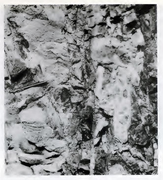
Figure 3: Section of a brecciated quartz vein with native gold. The pencil is about 13 cm. Reproduced from Chesterman et al., 1986.
The most productive veins in the district were those in the Standard Hill area, which are divided into three series of veins: the Incline, Fortuna, and Burgess, in order of decreasing productivity (Chesterman et al., 1986). The Incline veins are mostly between 36 cm and 2 m wide, run generally north to north-northeast and dip between 40 and 65 degrees to the west (Chesterman et al., 1986). The older veins in the series are banded flinty quartz, fractured in some places and associated with red clay, while the younger veins are more porous and crumbly (Chesterman et al., 1986). The vein series was rich in gold to 150 meters below the surface (Chesterman et al., 1986). The Fortuna vein series contained the richest ore in the Bodie mine; it ran north-northeast and dipped 30 to 45 degrees to the east, with an average width of less than 70 cm (Chesterman et al., 1986). The series was rich in gold down to 300 m; the vein’s quartz also contained silver, argentite, pyrite, and sphalerite (Chesterman et al., 1986). The Burgess series also ran north–northeast, dipping to the east, and included very gold–rich deposits in ground–up host rock and clay along the edges of the vein (Chesterman et al., 1986).
Geologic History of the Bodie Mining District
The intrusive granitic rocks which underlie the more recent volcanic rocks of the district are related to the Sierra Nevada batholith (Herrera et al., 1993). The batholith formed as a result of flux melting as the Farallon plate subducted under the North American plate 150 Ma ago (Hill, 2006). As the plate subducted, volatiles, such as H2O were released, which melted the rocks above the plate, which in turn rose upward due to their low density (Hill, 2006). These magma bodies solidified to form the granitic rocks under the district, but some of it must still have been molten recently to allow for the extrusion of lava and ash, as well as the young dacite plugs and still–active hot springs. The faults formed after the emplacement of the dacite plugs ((Chesterman et al., 1986). The approximately north–oriented faults coincide with the pattern of similarly oriented faults that dominate the Great Basin province as a result of the crust stretching as it is pulled at the contact between the North American and Pacific plates (John, 2001).
Hysrothermal Systems and Alteration
Following the volcanism of the district, the tuff breccia and other volcanic products began to be altered by hydrothermal activity, first propylitic, then argillic, potassic, and silicic (Chesterman et al., 1986). Propylitic alteration, alteration by fluids rich in Fe, Mg, and Na, precipitated chlorite, sericite, epidote, quartz, pyrite, and hematite (Chesterman et al., 1986). Argillic alteration, alteration by acidic fluids, precipitated quartz, chalcedony, montmorillonite, kaolinite, carbonates, and pyrite (Chesterman et al., 1986). The next phase, potassic alteration, was limited to the Bodie Bluff and Standard Hill plug area and resulted in potassium feldspar making up a large component of some quartz veins (Chesterman et al., 1986). Silicic alteration is restricted to the central portion of the district and played a part in the formation of quartz veins and the silicification of the tuff (Chesterman et al., 1986). The fluids in the system were mostly meteoric water between 215 and 250°C that rose to the surface similarly to the hot springs that are active there now (Herrera et al., 1993).
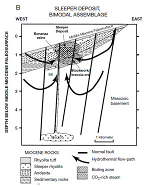
Figure 4: The schematic diagram shows a possible model for hydrothermal systems similar to that of Bodie. Reproduced from John, 2001.
Looking at the three parts Danskin (1998) divided the valley into and fitting them into the information provided by the Owens Valley Committee, it suggests that all three of those categories of water of have been affected by the aqueduct system. The unsaturated zone has less snowmelt and runoff periodically coming through it because upstream water is being diverted. The multiple dams and reservoirs scattered throughout the Valley, as well as the fact that Owens Lake is now dry, show how surface water is being diverted by the LADWP. Finally, the saturated groundwater system is also being pumped to the aqueduct, further depleting the area of water resources.
As shown in Figure 4, the water source is meteoric, meaning that it comes from the atmosphere and infiltrates into the ground (John, 2001). As it goes closer to a stock of magma, it is heated and flows back up faults, where it deposits minerals (John, 2001). This is a good model for the Bodie district because there is an extensive series of faults, which are parallel to the veins of ore. There is also a source of heat, the magma that must have been close to the surface as recently as about 8.5 Ma ago, when it formed the dacite plugs.
Conclusion
The Bodie mining district has a rich tectonic history. Beginning with the subduction of the Farallon plate under the North American plate 150 million years ago (Hill, 2006), Bodie was on a path to become the site of a major gold deposit. The magma generated as the Farallon plate released its volatiles, which then melted portions of the North American plate (Hill, 2006) provides the heat necessary to produce a hydrothermal system. Heat was not enough though, there also needed to be a route from the hot underground to the surface, which was provided by a series of normal faults caused by another tectonic event, the stretching of the North American plate as it was pulled at its contact with the Pacific plate (John, 2001). These two tectonic events allowed water to flow down from the surface, be heated up and dissolve ions, then rise back to the surface through faults and deposit minerals in veins near the surface (John, 2001). These veins were then mined and milled to retrieve the gold and silver they contained.
Works Cited
Butterman, W.C., and Earle B. Amey III. Mineral Commodity Profiles–Gold. Usgs.gov. United States Geological Survey, 2005. Web. 12 June 2012.
Chesterman, Charles W., Rodger H. Chapman, and Cliffton H. Gray. Geology and Ore Deposits of the Bodie Mining District. Sacramento, California: California Department of Conservation, 1986. Archive.org. Web. 7 June 2012.
Herrera, P.A., L.G Closs, and M.I. Silberman. Alteration and Geochemical Zoning in Bodie Bluff, Bodie Mining District, Eastern California. Journal of Geochemical Exploration 48.2 (1993): 259-75. Print.
Hill, Mary. Geology of the Sierra Nevada. 2nd ed. Berkeley: University of California, 2006. Print.
John, D. A. Miocene and Early Pliocene Epithermal Gold–Silver Deposits in the Northern Great Basin, Western United States: Characteristics, Distribution, and Relationship to Magmatism. Economic Geology 96.8 (2001): 1827-853. Print.
La Monica, Paul R. ’Au’-sterity Takes a Big Bite out of Gold. CNNMoney. Cable News Network, 14 May 2012. Web. 12 June 2012. website.
Scheck, Justin. Gold Fever Stirs Ghost Town. Wall Street Journal. N.p., 18 Aug. 2011. Web. 7 June 2012.
The California Gold Rush. California’s Natural Resources: A Brief History of the Gold Rush. California Resources Agency, n.d. Web. 12 June 2012. website.