Geology and Natural Heritage of the Long Valley Caldera
How Glaciation Has Shaped the Landscape of the Eastern Sierra Nevada
Keith Weisberg
Abstract
The Eastern Sierra Nevada’s landscape, ranging from Yosemite to Mono Basin, is heavily influenced by the effects of glaciation. Glaciers form in times of ice ages, which occur at times when the Earth’s climate is cooler. This can be predicted by Milankovich Cycles, which take into account the eccentricity, precision and obliquity of the Earth’s orbit and their respective effects on climate. This paper outlines glaciers from how they are created to their demise and how they affect the landscapes in which they exist. Glaciation leaves noticeable evidence and respective ice ages can have extreme differences on the changes in the landscape.
Introduction
The entire west coast of America has been dramatically shaped by geomorphology. The Horst and Graben systems that make up rolling basins and ranges cover the inner landscape. Earthquakes due to subduction activity between tectonic plates remind the population of California of the activity in the area. Further inland in the basin and range systems sits the Mono Basin, a natural low point and graben. The Sierra Nevada Mountains guard the western side of the basin as water drains naturally to Mono Lake, which lies at the lowest point in Mono Basin. All water in the Mono Basin Watershed leads to Mono Lake, which includes a significant portion of the Sierra Nevada Mountains’ melting snow. The water that doesn’t drain to Mono Basin makes it towards Hetch Hetchy, the aqueduct of San Francisco, and eventually the Pacific Ocean. While water has drained to these respective basins over the last hundreds of thousands of years, it was not always in the liquid form we see it in today. Enormous masses of ice known as glaciers used to rule the landscape of the Eastern Sierra Nevadas, having enormous influence in crafting the landscape we view today.
What is a Glacier?
Glaciers form near mountain tops when snow accumulates faster than it melts over a long period of time, therefore a glacier is originally a product of snowfall. Mountains are often covered in snow because of their height. The high altitude causes there to be less atmosphere and therefore lower temperatures. Clouds that are full of precipitation often leave snow on mountains they pass over. After a snow begins to accumulate, it can begin to crush itself under its own sheer weight. As the snow crushes itself, it can be compressed into solid ice. The air is squeezed out of the space that existed between the snow and it can recrystallize into large crystals of ice. A glacier is considered to be ice that is thick and persistent enough that it not only sags downhill under its own weight, but also can begin to flow due to this weight and gravitational forces acting upon it. Snow fields are phenomenon that can occur geographically along with glaciers. These are collections of snow that can be enormously thick like glaciers, but not thick enough that they have been compressed into solid ice. Glaciers are more prevalent during times when the Earth is colder, since this allows them more time to grow. The Earth naturally goes through periods of glaciation and periods of interglacial behavior.
The Ice Ages and Their Effects
During periods of glaciation the Earth tends to have significant increases in the amount of ice on the planet. Glaciers cover up enormous areas of land and change the landscape dramatically. These changes are so dramatic that each glacial episode tends to cover up the previous episode, so more is known about the newest glacial periods than those before them. During these time periods the sea level of the entire planet can rise or fall. "Since 1993 to 2008 the average sea level rose at a rate of 0.11 to 0.13 inches per year."
Milankovitch Cycles
While the Earth constantly orbits the sun, the actual eccentricity, precision and obliquity of the specific orbit vary in a predictable amount of years.
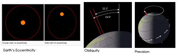
Earth’s Eccentricity, Obliquity, and Precision
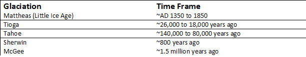
These variations in orbit, known as Milankovitch cycles, can have dramatic changes on the climate of the planet. How circular or elliptical the Earth orbit is, known as eccentricity, varies every 100,000 years. Precision, or the angle of the tilt of the Earth’s axis, varies every 26,000 years. The obliquity, "tilt of the Earth’s axis with respect to a direction perpendicular to its orbital plane," varies between a tilt of 22.1 degrees and 24.5 degrees every 41,000 years. All these affect how much sunlight the Earth receives. The eccentricity, precision, and obliquity added together to calculate the amount of sun received in the Northern Hemisphere of the Earth. Since most of the Earth’s currently sits on the Northern Hemisphere, the amount of sunlight that region receives has the greatest effect on the planets climate. As the climate changes on a geological time scale, the temperature of the planet increases and decreases. These changes usher in "ice ages," or periods of glaciation separated by "warm ages," known as interglacial periods. The last glacial maximum was known as the Tioga period and took place around 20,000 years ago.
The Anatomy of a Glacier
As glaciers move due to gravity, the different sections of a glacier can be recognized and labeled. The head, or very top, of the glacier is known as the zone of accumulation. Snow continues to fall at the zone of accumulation, which eventually gets compressed and increases the size of the glacier. Glaciers can move as solids when the ice reaches a thickness of 100 feet and are thickest at their center. As the glacier moves downwards and begins to melt, this marks the zone of ablation. The toe, terminus, or bottom of the glacier, can continue downwards until it begins to melt (or ablate). The size of a glacier changes in respect to the climate. The smallest rise drop in temperature can cause the toe to advance further downwards, while the opposite effect can lead it to retreat upwards. Temperature changes can also lead to a circumstance where the glacier isn’t fully frozen, allowing water to run through the glacier. The water can not only run out of the terminus of the glacier, but find its way out through the sides. The water often can refreeze and change the texture and strength of the glacial body as well .
How Glaciers Move and Interact With the Landscape
As glaciers move they have substantial and lasting erosion effects on the landscape. As the glacier slides past peaks and ridges it begins to sharpen the features. Large crevasses, known as bergschrunds, are clear indicates of glacial movement that separate stationary ice sections of a glacier from moving sections . Glacial erosion’s effects vary based upon the material that it travels past. As it travels past peaks and ridges, the features are sharpened. Near the head of the glacier horns and arêtes can be found. A horn is a sharpened peak that has been carved away by glaciers on more than one side, while an arête is a sharp ridge between two glaciers in which eroding both sides have sharpened it into a crest. If a glacier doesn’t cover a feature in its path, an "island" of a peak can be left in the glacier called a nunatak that is sharpened similarly to a horn or arête. As the glacier travels downwards, it can pick up and carry lose sediments and materials. Fractures in rocks can allow glaciers to slip into the cracks and "pluck" out materials. When water finds its way into these cracks and freezes, the pressure can help break up the rocks called frost shattering. This plucking process, also known as glacier quarrying is primary driver for many of the geomorphological effects glaciers leave behind.
As a glacier travels many micro–effects can occur. The larger plucked rocks can leave glacial grooves/striations in land that it travels. These gashes in rock that remains can reveal the direction of glacial travel. When felt they are smoother in the direction of travel that the glacier traveled in, while rougher in the opposite direction. As glaciers travel, the naturally break down rocks they pick up making them more rounded in shape than they were at their provenance. As the mixture of rocks grows, containing rocks ranging from silt to boulders it becomes glacial till. Glacial till can grind over hard rocks, leaving them polished instead of striated. The polished rock is known as glacial polish. Glacial till is one of the key indicators of glaciation evidence after glacial retreat.
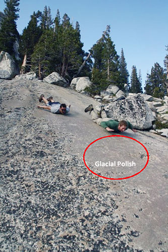
Glacial Polish on D.A.F.F. Dome, Yosemite, CA
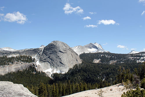
On a macro-level glacial travel can leave behind enormous landforms. The travel of glaciers smooth out most features turning most "V" shaped valleys they travel through into a "U" shape.
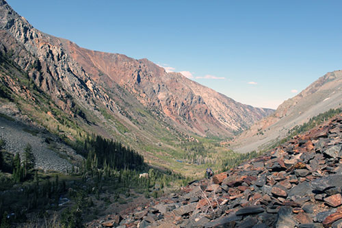
Lundy Canyon, Inyo National Forest, CA – A "U" Shaped Valley
Cirques are enormous valleys that are formed beneath the headwall of glaciers. The weight of glaciers causes these depressions in the ground, which remain long after glacier retreat. When the glacier is still frozen the water that may run through it can’t necessary overcome obstacles that the larger body of ice can. This water can pool in cirques or behind other features that the larger glacier travels over, leaving behind lakes. A lake left behind in a cirque or glacial basin is known as a tarn. One of the most beautiful features glaciers can leave behind is a hanging valley.
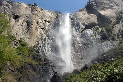
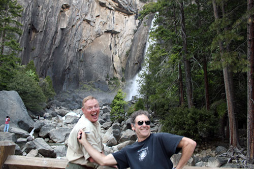
A Hanging Valley – Bridal Veil Falls, Yosemite, CA
A hanging valley is usually the creation of a smaller, tributary glacier that has met a much larger glacier at a level where their tops might be at the same height, but their bottoms differ. The melting of the ice causes the tributary glacier’s channel to be higher, often leaving a waterfall in place.
All glacial movement carries some degree of glacial till. These deposits of materials which are carried by a glacier, either from rock fall landing on top of the glacier or as glacial till under/within the glacier become left behind once the glacier retreats in the form of moraines. Moraines can be hundreds of feet high and provide the most significant signs of evidence of past glaciation. Many different kinds of moraines can be created, depending on the movement of its parent glacier.
An Example of a Moraine from Mono Basin
When two glaciers come together, a medial moraine is created as they merge and drop their glacial till. Lateral moraines are created parallel to its parent glacier, often showing the primary movement of where the glacier once existed. Terminal moraines are created where the toe of the glacier lies. Recessional moraines are similar to terminal moraines, lying in areas where a glacier may have retreated temporarily, unlike terminal moraines which mark the end of glacier.
A moraine can be used to estimate when a glacier once existed within a landscape. Moraines start out as sharp features, but with time they begin to erode and become more rounded. Boulders that sit on the peak of a moraine can be indicators of age because as time passes less will remain. If boulders remain on the moraine, the degree in which they have weathered can provide an age estimate of their respective moraine. Cosmogenic radionuclide dating can be used to very accurately determine the age of a moraine. Cosmogenic radionuclide dating is expensive, but the most scientifically advanced way to determine the rate a rock has been on the Earth’s surface.
Simplified Glacial History of the Sierra Nevadas
Mattheas is the most recent period of glaciation. The largest significance of this glacial maximum to the landscape of the Sierra Nevada is the evidence of a few moraines. Evidence of the Tioga and Tahoe ice ages can be visibly seen throughout the Eastern Sierra Nevada and Mono Basin area.
The Sierra Nevada Mountains have a rich history of glaciation. The eastern side of the mountain range towards Mono Basin differs in how past glacial maximums have affected the land versus the western side towards Yosemite National Park. This is especially visible the in moraines, though the deposits in this area can easily have their ages confused though due to "incorrect stratigraphic correlations and from inaccurate dating."
The Mono Basin on the eastern side of the Sierra Nevadas was affected by heavy faulting. These formed many cracks within the rock that allowed frost shattering. Since more rocks were removed from this side, the crushed up rocks were eroded by glaciers. Moraines can be viewed throughout the landscape, since glacial till was easy to pluck.
Yosemite National Parks’ peaks consist of granite. Granite is an extremely strong rock which goes through a variety of heating and cooling. It has tightly packed big crystals which have inter-woven and grown with each other. The strength of granite makes it significantly more resistant to glacial erosion. Glacial polish and striation of rocks give evidence of glaciation, versus the larger amount of glacial till found in Mono Basin.
Conclusion
During this current intra–glacial period on the Earth few glaciers exist within the eastern Sierra Nevada region. Glaciation is one of the most prevalent features regards to how the area and their respective basins have been shaped. Hanging valleys have been replaced by waterfalls and most glaciers have been replaced by streams of melting snow. Evidence of sharpened peaks, enormous moraines, and large tarns left behind from the last glacial maximum show the incredible affect glaciers had on the entire landscape. This evidence will remain visible on a geological timescale, spanning until the land is once again covered in the enormous flows of ice known as glaciers.
Works Cited
The National Snow and Ice Data Center. All About Glaciers, Introduction. Cooperative Institute for Research in Environmental Sciences, University of Colorado Boulder, n.d. Web. 12 June 2012. website
Climate Change Indicators in the United States–Sea Level. EPA. Environmental Protection Agency, n.d. Web. 12 June 2012. website.
The Seasons and the Earth’s Orbit. The Seasons and the Earth’s Orbit. The United States Naval Meteorology and Oceanography Command (NMOC), 14 June 2011. Web. 12 June 2012. website
Hill, Mary. Geology of the Sierra Nevada. Berkeley: University of California, 2006. Print
’cirque.’ Encyclopædia Britannica. Encyclopædia Britannica Online. Encyclopædia Britannica Inc., 2012. Web. 12 Jun. 2012 website.
Glaciers and Icefields. Glaciers and Icefields. Tongass National Forest, 10 July 2002. Web. 12 June 2012. website.
Cryosphere Glossary The Cryosphere: Where the World Is Frozen. National Snow and Ice Data Center, n.d. Web. 12 June 2012. website.
Glaciers and Icefields. Glaciers and Icefields. Tongass National Forest, 10 July 2002. Web. 12 June 2012. website.
Dr. Allen Glazner – Lecture: Glaciers, Granite, and Moraines of the Eastern Sierra Nevada - website
Glazner, Allen F., and Greg M. Stock. Geology Underfoot in Yosemite National Park. Missoula, MT: Mountain Pub., 2010. Print.
This ice age did have disastrous effects on the human population’s food sources as well as shaped other sections of the world.
Clark, D., Gillespie, A.R., Clark, M., Burke, R., 2003, Mountain glaciations of the Sierra Nevada: in Easterbrook, D.J., ed., Quaternary Geology of the United States, INQUA 2003 Field Guide Volume, Desert Research Institute, Reno, NV, p. 287-311.
Note–All pictures in this paper were taken personal by Keith Weisberg and thereby have permission to be used.