Geology and Natural Heritage of the Long Valley Caldera
History of the Long Valley Caldera
Alicia Pardoski
Abstract
The history of the Long Valley Caldera is an active one that began 280 ma years before present with the building and eruption of Glass Mountain. With mild activity happening constantly, at 760,000 years ago a catastrophic eruption rocked the western US ejecting 600 cubic km into the air and creating the Long Valley Caldera. This eruption of the nameless volcano is preserved and seen today in the Bishop Tuff, or the welded ash fall. Today the area continues with its unrest, but not as actively as once before. Domes formed from the most recent of magmatic activity within the caldera, earthquakes rock the surface, uplift of the resurgent dome continues and carbon dioxide leaks into the air from depressurization from magma under lying Mammoth Mountain.
Glass Mountain Rock Types
Glass Mountain is made of a complex of rock rich in igneous history. Underlying the exposures of the more recent rock is an exposure of much older granodiorite rock.
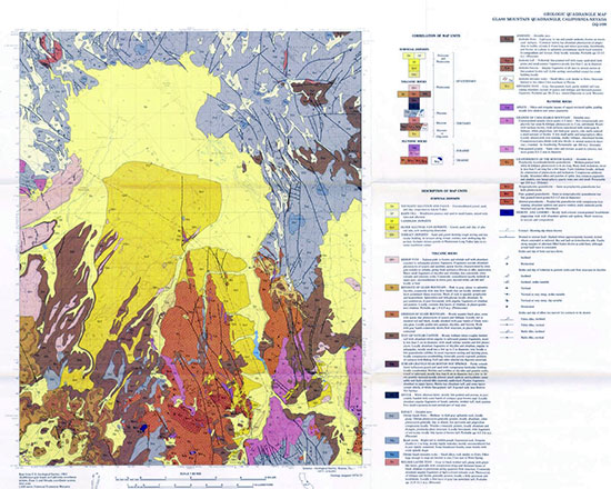
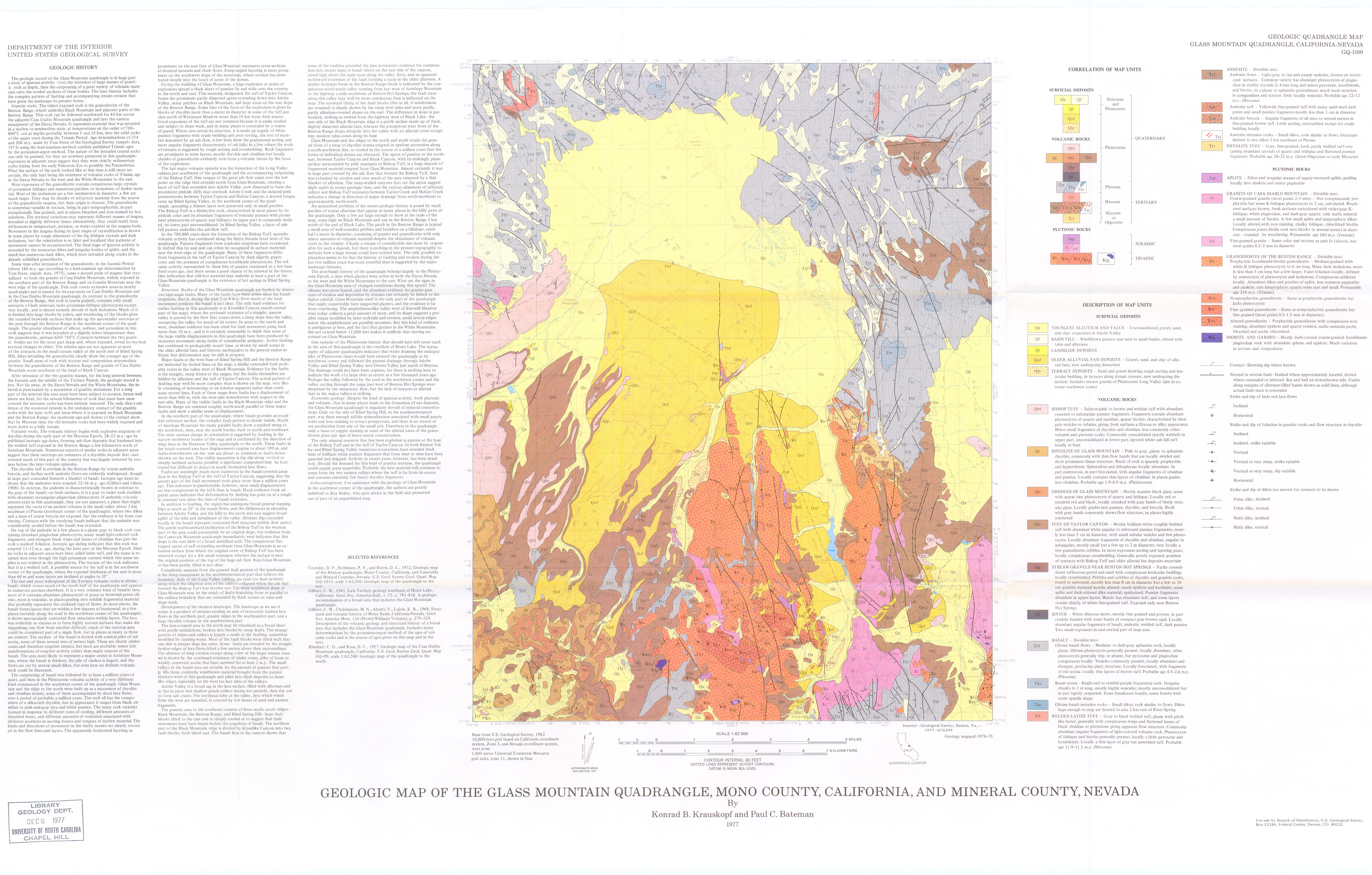
Figure 1 Geologic map of the Glass Mountain Quadrangle. Glass Mountain can be located in the lower left hand corner. Image shows rocks types discussed. [Image from Krauskopf and Batemn, 1977]
The exposure represents rock that was intruded in either a molten or at least a semi-molten state [Krauskopf and Bateman, 1977]. Using a lead-uranium method of dating the exposure was dated to be from the Triassic Period, between 214 and 280 million years old [Krauskopf and Bateman, 1977]. Study of the exposure shows that it varies in texture from very fine–grained to non–porphyritic, with large crystals of potassium feldspar and darker colored inclusions, the textural differences could mean that two different magma masses intruded at two different time, or this differences could be due to differences in temperatures, pressures, or water content [Krauskopf and Bateman, 1977].After the intrusion of the granodiorite a second body of magma solidified to form a granite, which formed about 160 million years ago based on the same kind of lead- uranium dating [Krauskopf and Bateman, 1977]. The granite is coarse grained, lacking both large amounts of the potassium feldspar and the dark inclusions of the granodiorite. The formation of Glass Mountain is the result of a series of rhyolitic and obsidian domes, which overly the granodiorite and granite as well as a basaltic rock reports Krauskopf and Bateman [1977]. Krauskopf and Bateman [1977] also report that the domes are accompanied by small flows which vary in rock types, appearing to have taken place over a period of a million years.
Structure
Faulting of the area has been active for about three to four million years states Krauskopf and Bateman [1977], fractured by high–angled faults. Glass Mountain, as well as other ridges, still retain the appearance of rhyolite domes, with areas to the northeast aproned with large deposits of broken up material erupted from Glass Mountain.
Bishop Tuff Eruption
Long Valley Caldera
Formed by the collapsing roof of a magma chamber which was evacuated by a catastrophic eruption about 760,000 years ago [USGS Long Valley Caldera, 2012]. The caldera itself is a 17 by 32 km oval shaped depression from a subsidence of about 2 km of the existing magma chamber [USGS Long Valley Caldera, 2012]. The eruption the caused the evacuation of the chamber lasted a period of six days in which about 600 cubic km of magma was blown out [USGS Long Valley Caldera, 2012].
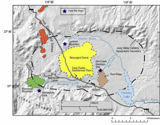
Figure 2 Simple map of the Long Valley Calerda, showing the boundary of the caldera in the dashed and dotted line. Highlighted are a few post caldera features, including Mammoth Mountain, the resurgent dome, and the Mono–Inyo Craters. [Image from USGS long Valley Caldera, 2012]
Bishop Tuff
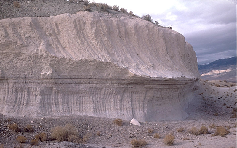
The Bishop Tuff is the name given to the ash fall deposits of the Long Valley Caldera eruption. Bishop ash settled as far east as Nebraska, being thickest at its origin, the caldera, about 1400 m thick. [Hill, 2006]. Pyroclastic flows continued for several days, evidence of this seen in exposures in the Owens River Gorge and the volcanic tableland [Hill, 2006]. The tuff can be easily divided into eight individual layers [USGS Long Valley Caldera, 2012]. The tuff is distinctive being pink in color, with phenocrysts of feldspar and quartz. The upper part is largely welded while the lower portion mainly unconsolidated [Krauskopf and Bateman, 1977].
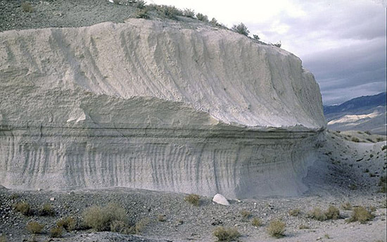
Figure 3 Image of an exposure of the Bishop Tuff ash deposit. Some layering is visible. Upper and lower portions easily distinguished by the vertical dark bands in the exposure. [Image from Wikipedia]
Post Caldera Activity
Resurgent Dome Uplift
Uplift of the caldera floor in the form of the resurgent dome is a sign that dormant volcano is becoming active once again [Sieh and LeVay, 1998]. In May of 1980 four magnitude six earthquakes shook the caldera and the towns around it, with this came the discovery that old survey points had uplifted ten inches since the year before [Sieh and LeVay, 1998]. This uplift promotes the idea that magma is still present beneath the quiet caldera and that the old magma chamber may be being inflated by new magma pushing its way to the earth’s surface [Sieh and LeVay, 1998]. As the years past the earthquakes along with the uplift of the resurgent dome continued, for the next two years scientist continued to record hundreds of earthquakes, most of which were located beneath the south moat of the caldera where the rock is covered with steep sloped fractures that mark the ring fracturing that formed the caldera [Sieh and LeVay, 1998]. Some of the movement was not consistent with normal side–way slippage, but rather it seemed that the earthquakes were caused by rocks being pulled apart which is consistent with fluid, fresh magma or water, pushing its way up from the magma chamber [Sieh and LeVay, 1998] By 1983 the uplift had reached 16 inches higher than previously recorded measurement from 1979 and the edges of the resurgent dome were pulling apart [Sieh and LeVay, 1998].
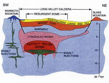
Figure 4 Image displays a simple cross–section of the Long Valley Caldera, showing the Bishop Tuff deposit, overlying caldera fill, and the magma chamber. The thick black lines edging the caldera are lines of faulting. [Image from Bigthink.com from an article about super volcanoes]
Mammoth Mountain
Mammoth Mountain sits on the southeast part of the caldera rim. About 220,000 years ago Mammoth began to form from twelve domes [Hill, 2006]. The magma constructing this volcano was thick, most new layers stacking up on top of the others, with occasional explosions and ash and pumice pouring from vents [Hill, 2006]. The latest magmatic eruption of Mammoth was about 57,000 years ago, but more recent phreatic eruptions happened only 700 years before present [USGS Long Valley Caldera, 2006]. The magmatic system that fuels Mammoth is the same that fuels 35 magmatic vents in the immediate area, including the Red Cones [USGS Mammoth Mountain, 2012]. In recent years the volcano has experienced years of unrest in the form of earthquakes, ground uplift, and volcanic gas emissions, which is said to be attributed to the dike intrusion lying below Mammoth Mountain [USGS Mammoth Mountain, 2012].
Domes
Three domes exist within the Long Valley Caldera, Dead Man Creek Dome, Glass Creek Dome, and Obsidian Dome. All these domes are relatively the same age, about 550 years old. A series of eruptions formed these distinct features starting with Dead Man Creek vent, then Odsidian vent, followed by the Glass Creek vent [USGS Inyo Eruptions, 2004]. The magma that fuelled these eruptions probably was fed to the surface through a dike [USGS Long Valley Caldera, 2012] These eruptions likely began with phreatic eruptions followed by pyroclastic eruptions and then ended with passive lava extrusions that built up the domes [USGS Long Valley Caldera, 2012].
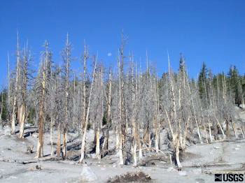
Figure 5 Shows trees that have had their roots killed by over exporsure to carbon dioside in the soil around Mammoth Mountain by Horseshoe lake.
CO2 Tree Kill
In 1990 the Forest Service noticed that trees in the area were dying. At first this was believed to be due to the ongoing drought; in March of that same year a ranger experience the feeling of being suffocated upon entering a snow covered cabin [Sieh and LeVay, 1998]. Following several more similar incidents the toxin was concluded to be carbon dioxide, which was normally present in small amounts, at higher concentrations the gas can kill tree roots and suffocate humans [Sieh and LeVay, 1998]. Carbon Dioxide levels in the soil were ranging from 20 to 90 percent, where in normal conditions carbon dioxide levels were below one percent [Sieh and LeVay, 1998]. Evidence linked the carbon dioxide was coming from Mammoth, one line of evidence being that when the gas was analyzed it had a ratio of different isotopes that were characteristic of gas released from magma [Sieh and LeVay, 1998]. Carbon dioxide release has continued since 1990, but this does not necessarily indicate an eruption in the near future, more likely to have phreatic eruptions produced from magma interacting with groundwater [USGS Future Eruptions of Long Valley, 2012].
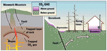
Figure 6 Shows the behavior of carbon dioxide as it escapes the magma through depressurization.
5. Conclusion
The Long Valley Caldera has been, and seems always will be a very active place of volcanism. Activity in the area has continued for millions of years, ranging from huge eruptions to minor earthquakes. Unrest is common at this place and further eruptions are not only likely but expected to happen, but not likely within our lifetime.
Works Cited
Bishop Tuff. Wikipedia. N.p., n.d. Web. 12 June 2012. website.
CO2 Gas Killing Trees. USGS, n.d. Web. 12 June 2012. website.
Hill, Mary. Geology of the Sierra Nevada. Berkeley: University of California, 2006. Print.
Krauskopf, and Bateman. Geologic Map of Glass Mountain Quadrangle. N.p., 1977. Web. 12 June 2012. website.
Mammoth Mountain. USGS, n.d. Web. 12 June 2012. website.
Long Valley Caldera. Long Valley Caldera. USGS, n.d. Web. 12 June 2012. website.
Sieh, Kerry E., and Simon LeVay. The Earth in Turmoil: Earthquakes, Volcanoes, and Their Impact on Humankind. New York: W.H. Freeman, 1998. Print.
themanyfacesofspaces.com. Yellowstone. Super Volcano: Cross section of the Caldera. website