Geology and Natural Heritage of the Long Valley Caldera
Geologic History of the Mono Basin
Elizabeth Nixon
Abstract
The Mono Basin, an elongated tectonic depression on the western edge of the Basin and Range Province, is a well–preserved region rich in geologic processes and history. For the purposes of this paper, the account of the Mono Basin begins at the stretching and thinning of the basin 5mya and continues through today. Since the subduction of the Farallon sea floor plate 20mya, thinning and expansion of the basin and range, as well as potent earthquake activity, has led to extensive faulting along the eastern front of the Sierra Nevada. The millions of years postdating the initial process of expansion exhibit evidence of systematic glaciation, catastrophic volcanism (especially in the Long Valley region, where approx. 150 cubic miles of ash was expelled from the earth), and intensive tectonic change. The faulting process on the eastern Sierran front lasted until around 40kya, when the role played by the fault escarpment was replaced by the intrusion of northwest-striking dikes along the surface of the basin. These dikes have fed the more recent volcanism of the area, and hold the highest potential for further volcanic activity in the near future.
Introduction
The Mono Basin, an elongated expanse situated in eastern California, marks the westernmost basin of the geologic landscape commonly known as the Basin and Range Province. For the purposes of this paper, the basin will be described as the area bounded by the Bodie Hills to the north, Cowtrack Mountain to the east, the Long Valley Caldera to the south, and the Sierra Nevada Mountains to west (See Appendix A for map). This tectonic depression is the site of well-preserved geologic landforms, exhibiting signs of several geomorphic processes including numerous periods of glaciation and volcanism. Its defined geomorphic characteristics allow the geologic history of the region to be traced back from the recent volcanism of the Mono–Inyo Craters through the initial tectonic processes for which the basin and range are known.
Tectonic Situation of the Mono Basin Resion
Tectonics
The basin and range characteristics of the Mono Basin region are largely attributed to the ancient tectonic situation of western North America. Some 20 million years ago (mya), the final exposure of the Farallon sea floor plate slid under the North American plate, eliminating the remaining space between the Pacific sea floor plate and the North American continental plate. Instead of creating a convergent plate boundary like its predecessor, however, the Pacific sea floor plate encountered the North American continental plate and sheared against it in dextral motion, creating a transform boundary that would generate the modern San Andreas Fault. This unusual process created a gap behind the subducted Farallon plate, exposing the lithosphere of the overriding plate to the aethenospheric mantle beneath, a process referred to as the "slab–gap" theory. Due to this high-temperature contact, the lithosphere has been stretching, thinning, and sometimes fracturing, contorting the land into the sinking basins and uplifted ranges that we witness today (Tierney 2011).
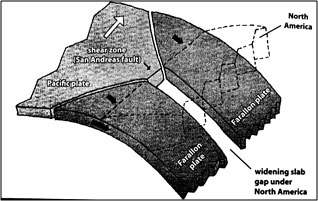
Figure 1: (Tierney 2011) This diagram illustrates the "slab–gap" theory as it pertains to the tectonic history of western North America. The exposure of the North American continental plate to the mantle allowed for expansion and creation of the Basin and Range Province.
Early History of the Mono Basin
The initial contortion of the Mono Basin began sometime around 5mya, with consequent block faulting occurring along the eastern front of the Sierran range (WETMAAP 2000). In the time since the origination of the Mono Basin, the Sierran front has risen approximately 4,000ft, while the basin has sunk about 6,000ft, leaving the estimate of differentiation between the crest of the Sierras and the trough of the basin at approximately 1,100ft (Tierney 2011).
At roughly the same time the block faulting and creation of what is currently called the Sierra Nevada frontal fault escarpment, down-warping of the region became evident in what Bailey (1976) described as the "broad, warped, faulted, graben–like depression" of the shorelines of modern Mono Lake. This down–warping remains an indication of a large zone of "reverse–drag" that can be observed throughout much of the Mono Basin (Bailey, et all. 1976).
Figure 2: Map adapted from Bailey (1976) to illustrate reverse drag zone in the Mono Basin.
Basin and Range Volcanism
The thinning and faulting of the western lithosphere of the North American continental plate provided a route for upwelling of basalt from the underlying mantle to reach the continent through fractures in the earth – a process which can be held responsible for the subsequent volcanism of the region. A strong period of mafic volcanism commenced in the area around the same time the warping began, erupting east and west of the Mono Basin. The most prominent of these eruptions occurred in the vicinity of Cowtrack Mountain. It was also during this period of volcanism that the younger portion of the Bodie Hills was created (Tierney 2011). Although the sizes and variations of eruptions would differ throughout the ages, this same volcanic period can be traced through millions of years and even persists through major glaciation within the area.
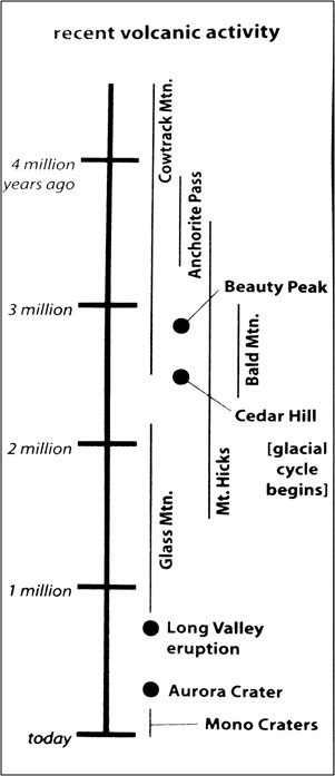
Figure 3: Chronology of volcanic events dating back 5my (Tierney 2011).
Pre–Tahoe Glaciation
There is some controversy surrounding the existence and remnants of pre-Tahoe glaciation in the Mono Basin, especially concerning its relationship to the Sherwin glaciation of 730 thousand years ago to 900 thousand years ago (kya)–this age estimated by Tierney (2011) and also a source of controversy. Due to the lingering uncertainty concerning the nature and age of the glaciation, for the purposes of this paper this glacial period will be referred to as simply "Pre–Tahoe," believed to have taken place during the late Pleistocene Epoch.
Controversy aside, there is little argument about particular effects of this glacial age. This pre–Tahoe glaciation is largely accredited with the glacial excavation of the eastern Sierra range, evidenced by the trademark U–shaped valleys and peaked arêtes that would later be sculpted further by younger glaciations. Other evidence of the existence of an enormous glacier during this time period are heavily eroded masses of glacial till deposits, which can still be found around Rock Creek, Lee Vining Creek, and in several areas beneath the Bishop Tuff (Bailey 1989).
This Pre–Tahoe glacier was arguably the most extensive glaciation in the Sierra, completely enveloping the Yosemite Valley and several other nearby areas. Further evidence of the massive reach of this glacier include heavily worn, scattered granitic erratics throughout the area that could only have been transported from the mountains by a glacier the size of this Pre–Tahoe episode (Huber 1938).
Long Valley Magma Chamber
Creation and Composition of Chamber
Sometime during the faulting and warping of the Mono Basin, a chamber began to form underneath what is today known as the Long Valley Caldera. This chamber, originally of the same basalt that had penetrated the continent and erupted around Cowtrack Mountain, has been the main source of volcanic magma over the last 3 million years in the Mono Basin. The basaltic magma of origin, however, slowly began to melt away the granitic rock surrounding the chamber and thus the compositional makeup of the magma has changed over the last 3 million years (Tierney 2011).
This compositional change can clearly be evidenced within the chronology and classification of eruptions within the Mono Basin throughout this time period, beginning with the basaltic eruptions of Cowtrack Mountain (Figure 3). After the eruptions at Cowtrack Mountain around 2.5–4.5 mya, Beauty Peak, Cedar Hill, and Bald Mountain erupted with more force and explosion—direct evidence of an andesitic mix of basalt and granite. Only half a million years later, Glass Mountain began its volcanic processes, by which time the composition of the lava had transformed into a distinctly granitic material. (Tierney 2011)
Eruption of Long Valley
As the composition of the magma changed, the granite surrounding the chamber began to melt faster than the newly formed granitic magma could erupt. With this enormously viscous material building up massive amounts of pressure beneath the surface of Long Valley, an eruption of outstanding magnitude became a necessary outlet. Around 760kya, Long Valley erupted in a magnificent rhyolitic explosion dwarfing any modern–day counterpart. This explosion ejected around 150 cubic miles of ash at enormously high temperatures, covering parts of the southwestern Mono Basin in over 600ft of ash. Among the most noted remnants of this enormous eruption are the miles of tuff in the caldera and surrounding area known today as Bishop Tuff (Tierney 2011). The caldera itself represents the post-eruption collapse of the Long Valley magma chamber, currently exhibited as an elongated depression running around 30km in width and 15km from the northern rim to the southern rim, and continuing into the earth to a maximum depth of 3km (Pakiser 1976).
Postcaldera Tectonics
The eruption of the Long Valley chamber coincides with a spike in movement along the formerly mentioned Sierra Nevada frontal fault escarpment where several meters of postcaldera offset are noticeably discernible. While the Long Valley chamber solidified, an organization of north–trending fissures expelled basaltic and trachyandesitic lavas as well as pyroclastic material. These eruptions are believed to be a consequence of faulting along the eastern front of the Sierran range, originating from a much deeper source of mafic magma. Evidence of mafic volcanism extends from southwest of the Long Valley caldera all the way through the northwest shore of Mono Lake, revealing this enormous network of fissures running parallel to the eastern front of the Sierra Nevadas (Bailey, et all. 1976). The importance of this network will be discussed as it correlates to the existence of the Mono–Inyo Craters, a chain of volcanic structures that run along its system.
As a further note regarding the chronology of geologic events, it is important to note existing theories concerning the timing of the Long Valley eruption in relation to the Pre–Tahoe glacial episode. Outside of the Mono Basin, but still relevant to the region, evidence of glacial interaction with Bishop Tuff suggests that there was a glacial episode persisting through the eruption of Long Valley and for a time afterward. This interaction is evidenced by transported glacial erratics and scattered within the caldera, clearly transported after the eruption and potentially ice–rafted across what once may have been a lake within the caldera during the immediate postcaldera time period. This episode would have occurred either during the tail end of the main Pre-Tahoe event, or theoretically could evidence a younger, smaller glacial occurrence in the area (Bailey 1989).
Further Glaciation
Further stages of glaciation in the Mono Basin area resumed around 120kya, with the beginning of what has been labeled the ’Mono Basin’ glaciation. Chronologically, the full glacial cycle only came to an end around 11kya, after cycling through the Mono Basin glaciation, Tahoe glaciations, Tenaya glaciation and Tioga glaciation, respectively. Each glacial event has been studied extensively for the sake of understanding their timeline, and while controversy still exists, the order listed above is now a chronology that is generally agreed upon in the scientific world (Tierney 2011).
The Mono Basin is a particularly fascinating area for those studying the glacial chronology of the Sierra Nevada range, principally due to the well–preserved moraines of Bloody Canyon. The semi–arid climate and relatively low rate of erosion contribute to an ideal location for the preservation of glacial remnants, with many of the differentiating factors between glaciations discernible to the naked eye. In general, the age of a moraine can be approximated by scrutinizing the amount of erosion that has occurred, due to the uniform rate of erosion in the basin. No matter the timing of the glacial deposit, no moraine will erode faster than another, which provides the trained observer with a clearer distinction between glacial episodes. If a moraine dates back to deposits of a glaciation such as the Mono Basin glaciation, the evidence of pre–existing surface boulders will have eroded away, and the moraine itself will be wider and diminished in elevation (Sampson and Smith 2006).
Dating back to around 60 ±75kya, the Tahoe glaciations (sometimes referred to as Tahoe I and Tahoe II) display a slightly younger set of age markers than that of the Mono Basin glaciation. The surfaces of these moraines tend to also be highly eroded with mild slopes, but still display a few heavily weathered boulders visible on the highly developed soil that has established itself over thousands of years. Younger moraines, left by the Tenaya glaciation, date back to 24 ± 30kya and tend to have sharper crests and visible stones that are significantly less weathered than those of Tioga or Mono Basin glacial origin. Encircled by Tenaya moraines, the youngest moraines of the Tioga glaciation (dating back to 11 ± 21kya) exhibit the highest elevations and largest expanses of surface boulders (Sampson and Smith 2006).
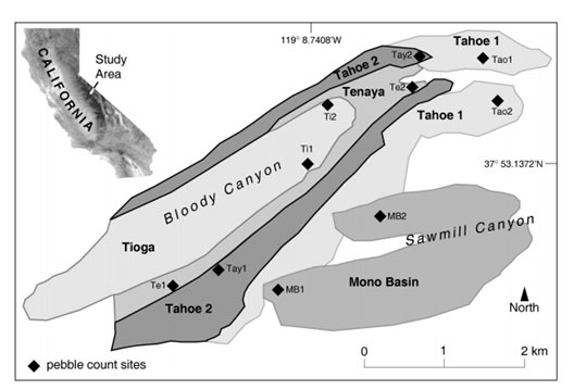
Figure 4: Glacial moraines in Bloody Canyon, classified by Sampson and Smith (2006). "Pebble count sites" refers to the method utilized to classify each moraine.
Mono-Inyo Colcanic Chain
Mono Craters
The Mono–Inyo Craters, notorious long after the extinction of the Tioga glaciation, lie on the previously mentioned network of northbound fissures that range from the southern end of the caldera through the north shores of Mono Lake. It has been hypothesized that several other craters may have been in existence throughout the lifespan of these fissures, which could date back to the beginning of the Sierra Nevada frontal fault escarpment. However, today such craters would lie buried beneath the exposed material of the more recent volcanoes. The exposed Mono Craters, generally older and more rhyolitic than their southern Inyo counterparts, range from around 630ky on the southern end to as young as Panum Crater, aging at only 600 years (Hill, et al. 2002).
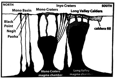
Figure 5: Magma chambers underneath the Mono Basin and Long Valley Caldera (Tierney 2011).
The most active movement and expansion of these fissures coincides with the creation and volcanism in the craters, which dates back to about 40kya. Around this time, the fault systems running parallel to the Sierra Nevada frontal fault escarpment began to slow and eventually cease expansion and activity. Bursik and Sieh (1989) hypothesized that the pressure from tectonic action, normally contributing to the expansion of fractures and faults in the region, found a new outlet in the form of extensive dikes that have extruded magma from the underlying network of fissures. Any fault extension continuing in the Mono Basin continues only at a small fraction of the rate that once constituted normal activity for the escarpment (Bursik and Sieh 1989).
From the spike in volcanic activity 40kya to a period of time around 14kya, the extension of dike intrusion corresponded to calculated fault-slip rates, suggesting that the dikes are indeed responding to regional crustal stretching, replacing the earlier role of the frontal fault system. The extension of these fissures and their application as an alternate form of pressure release would offer a sufficient explanation not only for the pause in fault activity but also for the source of magmatic eruptions in the Mono-Inyo Craters (Bursik and Sieh 1989).
The most recent eruptions within the Mono Craters mark the origin of North Coulee, Panum Crater, and several surrounding domes around 630 years ago. These eruptions are the direct result of a feeder dike estimated to be around 8–10km in length, a dike which is thought to have sourced several other vents in the area. (Hill, et al. 2002)
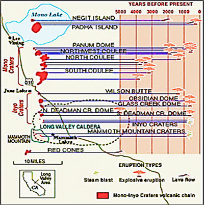
Figure 6: (Hill, et al. 2002) Volcanic activity in the Mono–Inyo chain within the last 5000 years, illustrated with regard to age and variation of eruption. Volcanic activity in the region began around 40kya and has continued through the recent creation of Paoha Island. Black Point, also a local volcanic region, is excluded from this diagram.
Inyo Domes and Craters
The Inyo craters and domes, younger than their northern neighbors, mark a notable mixture of pumice and obsidian hypothesized to be the result of Mono Craters magma intermingling with residual magma from the Long Valley chamber. The Inyo region displays a wide mix of rhyodacitic and rhyolitic material that has sparked interest in the geologic world for some time (Bailey, et all. 1976).
Fed by an 11km dike that could potentially be sourced by both magma from the Long Valley Caldera and magma from the chamber beneath the craters, the most recent eruptions in the Inyo Domes have occurred on the south end of the area, creating three craters of phreatic origin within the bounds of the caldera (Bursik and Sieh 1989.
Lying within the basin are three magmatic domes entitled Wilson’s Butte, Obsidian Dome, and Glass Creek Dome (running north to south, respectively). Also of phreatic origin, the domes also exhibit pyroclastic deposits from historic eruptions that predate the final, passive phase of their eruptive cycle in which magmatic extrusion expands the dome. Eruptions within the area most likely occurred 600–700 yrs ago (U.S. Geological Survey 2006).
Black Point
Black Point, one of the most striking volcanic features in the Mono Basin, lies just on the northern coast of Mono Lake. It last erupted around 13,300yrs ago, during the peak of the Tioga glaciation. During the Tioga glaciation, Mono Lake, existing as Pleistocene Lake Russell during the glacial episode, possessed a much more elevated shoreline than that of today. At this point in time, Black Point was completely submerged beneath the lake, causing subaqueous volcanism that is today verified by the presence of tufa along the walls of exposed fissures in the area, which is a process only possible underwater. (Tierney 2011)
Negit Island
South of Black Point, within the waters of present-day Mono Lake, Negit Island ages at around 1600 years and is entirely composed of black basalt. Its last eruption is estimated to have been only 270yrs ago (Tierney 2011). Seven different lava flows derived from four different vents in the island testify to the island’s volcanic nature, which sources from the same northwest-striking fissures that feed the Mono-Inyo volcanic chain. On the north end of the island, pyroclastic deposits suggest subaqueous volcanism sometime in the island’s earlier history, and surrounding lake sediments indicate that the island might have once been similar to its younger neighbor, Paoha Island (Bursik, Kobs and Jayko 2008).
Paoha Island
Paoha Island, lying within Mono Lake just south of Negit Island, marks the creation of a 250 year old shallow crypto-dome beneath the lake. Its light color and composition reflect a makeup that consists of mostly unconsolidated lake bed sediments. Still a volcanic island, however, Paoha provided the location for a relatively small volcanic eruption of andesitic lava from the north side of the island (Hill, et al. 2002). Paoha is well-known for its hot springs and steam vents, signaling a potential for further volcanic activity in the area (Tierney 2011)
History of Mono Lake
Lake Russell and Creation of Mono Lake
The history of Mono Lake continues all the way back to its Pleistocene ancestor, Lake Russell, making it arguably one of the oldest lakes in North America. This enormous lake once filled the entirety of Mono Basin, predating most of the previously discussed landforms by several thousand years. The lake was so large that during several periods of its height, it would spill over the basin rim into the Adobe Valley and surrounding areas, leaving remnants on the eastern rim of erosion caused by this overflow. This spill point, however, was constantly changing due to late Tertiary and Quaternary volcanism and faulting. The height of the lake shore is indicated by what can only be described as the remaining marks of a ’bathtub ring’ measuring at 2155m and 2188m above sea level. As the freshwater lake receded, the lake lowered to become the saline remnant today known as Mono Lake (Reheis, Stine and Sarna–Wojcicki 2002).
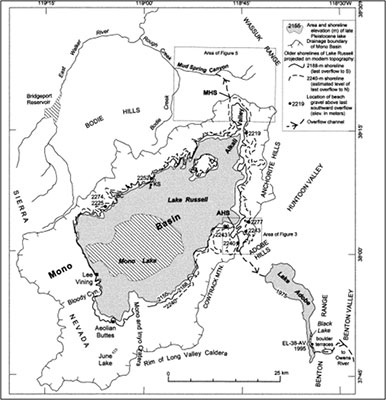
Figure 7: Map of Lake Russell shoreline and overflow channels during the Pleistocene Epoch (Reheis 2002).
Water Composition of Mono Lake
The water of today’s Mono Lake is highly alkaline and rich in chlorides, carbonates, and sulfates. The chloride in the water most likely originates from local eruptions in the area, while the carbonates are a likely result of silica reacting with atmospheric carbon, producing HCO3 (the silica being dissolved from igneous rock by the streams that feed the lake). With evaporation as its only outlet, Mono Lake is described as a very saline terminal lake, full of salt and other chemicals left behind by evaporated water (Tierney 2011).
Salt Playa of Mono Lake
At the northeast end of the lake lies a vast stretch of salt which, while generally attributed to the receding level of the lake and thus higher exposure of the salt beneath, is actually an active, ongoing process. At this end of the lake, fresh, shallow groundwater is overrun by the salinity of the lake, leaving only a surface of salt as the groundwater evaporates straight from the earth. On this side of the lake, alkali particles can be witnessed flying violently up into the air, blown by heavy winds which can create a somewhat toxic temporary atmosphere in the area (Tierney 2011).
Tufa of Mono Lake
The formation of tufa in Mono Lake has been a constant source of tourism for the area, as towers of the chemical concoction stand passively, exposed by the receding lake line and looking somewhat exterraneous. These towers are a mixture of calcium and carbonate, supplemented by calcium from the springs feeding the lake. As the calcium–rich water enters the carbonate–rich lake, the chemical reaction forms a relatively solid tower of this white tufa. This process, previously noted in the Black Point fissures, can only take place underground, and is therefore a good indicator of the historic lake levels of the area (WETMAAP 2000).
Current Situation of Mono Lake
While the lake dates back to the Pleistocene Epoch, its current situation warrants some concern for the lake’s continued well–being. Starting in 1941, the Los Angeles Department of Water and Power began diverting four of the five major streams feeding Mono Lake, causing the lake to plummet 45ft in level and lose around half of its volume. With this drop in level, the salinity of the lake rose drastically, offsetting the delicate ecosystem that survives in the area (Mono Lake Committee 2012).
In 1978, when the Mono Lake Committee was founded, the legal battle to save the lake began. While the battle continued up until 1994, the solution found favored the restoration of the lake, restricting the diversion of water to allow for the lake to return to its ecologically healthy level of 6,392 feet above sea level. With continued support and enforcement of the legal agreement, the hopeful future of Mono Lake stands as a landmark for environmental cases throughout the country (Mono Lake Committee 2012).
The Future of the Mono Basin
Potential Eruption Locations
The violent volcanic past of the Mono Basin and its surroundings provides a foreboding sense of caution for the inhabitants of the area. The United States Geological Survey has identified almost all of the areas mentioned in this document as potential stages for future activity, but the Mono-Inyo craters hold the highest statistical probability for eruption in the near future. As volcanic episodes in the history of the Mono Basin have cycled through eruptive episodes lasting for up to one million years, the relative age of the Mono-Inyo Craters signifies a low likelihood that their eruptive cycle has ended. With the threat of Mono-Inyo craters as well as potential activity in the Long Valley Caldera and nearby Mammoth Mountain, the USGS has developed a functional system of alert in order to improve procedure in the case of an eruptive event (U.S. Geological Survey n.d.).
Potential Eruption Types
With potential eruptions within the Mono Basin area quite likely, it is important to consult the geologic history of the region to determine the likely type of explosion that may occur in the near future. Logic dictates that eruptions from the past are possible indicators of the size, classification, and magnitude of future eruptions in the basin, and since the geologic record of the area indicates a recent cycle of granitic eruptions, the most likely eruption will presumably be of a more rhyolitic and explosive nature, theoretically preceded by a phreatic event. However, the decisive factors concerning volume and composition in a future eruption will be location, which is difficult to predict in an area so rich with volcanic activity (Hill, et al. 2002).
Conclusion
The volcanism witnessed in the Mono Basin and the well–preserved glacial remnants of the area make the Mono Basin a prime location for the study of geological processes. In a basin surrounded by so many geologic features, Mono Lake has drawn many geologists from all over the world to add their theories to the tumultuous mix of ideas, each idea contributing a new twist to our understanding of the region’s geologic history. As dating techniques evolve and become more accurate, the importance of this area to understanding earth science develops as well, from the subduction of the Farallon Plate to the preparedness required to survive volcanic threats of modern times.
Appendix A: Map of Mono Basin
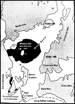
Appendix A: Map of Mono Basin, adapted from (Tierney 2011) to include more detailed locations of mentioned areas. 1) Bloody Canyon 2) Black Point 3) Negit Island 4) Paoha Island 5) Beauty Peak 6) Mono Craters: Listed North to South – Panum Crater, North Coulee, Crater Mountain, South Coulee, Devil’s Punchbowl 7) Aeolian Buttes 8) Inyo Craters (listed North to South – Wilson’s Butte, Obsidian Dome, Glass Creek Dome 9) Aurora Crater 10) Mt. Hicks
Works Cited
Bailey, Roy A. Geologic Map of Long Valley Caldera, Mono–Inyo Craters Volcanic Chain, and Vicinity, Eastern California. Department of the Interior US Geologic Survey, 1989.
Bailey, Roy A, G Brent Dalrymple, and Marvin A Lanphere. Volcanism, Structure, and Geochronology of Long Valley Caldera, Mono County, California. Journal of Geophysical Research, 1976: 725–44.
Bursik, M, S Kobs, and A Jayko. Volcanic Geology of Negit Island, Mono Lake, CA. American Geophysical Union, 2008.
Bursik, Marcus, and Kerry Sieh. Range Front Faulting and Volcanism in the Mono Basin, Eastern California. Journal of Geophysical Research 94, no. B11 (November 1989): 15,587-15,609.
Hill, David P, et al. Response Plan for Volcano Hazards in the Long Valley Caldera and Mono Craters Region, California. Bulletin, United States Government Printing Office, 2002.
Huber, N King. The Geologic Story of Yosemite Valley. U.S. Geological Survey, 1938.
Mono Lake Committee. About Mono Lake. 2012. website (accessed June 8, 2012).
Pakiser, LC. Seismic Exploration of Mono Basin, California. Journal of Geophysical Research, 1976: 3607–3618.
Reheis, Marith C, Scott Stine, and Andrei M Sarna–Wojcicki. Drainage Reversals in Mono Basin during the late Pliocene and Pleistocene. Geological Society of America, 2002.
Sampson, Kevin M, and Laurence C Smith. Relative Ages of Pleistocene Moraines Discerned from Pebble Counts: Eastern Sierra Nevada, California. V.H. Winston and Son, Inc, 2006.
Tierney, Tim. Geology of the Mono Basin. Lee Vining: Kutsavi Press, 2011
U.S. Geological Survey. Geologic History of Long Valley Caldera and the Mono-Inyo Craters Volcanic Chain, California. n.d. website (accessed June 8, 2012).