Geology and Natural Heritage of the Long Valley Caldera
The Beauty of Granite and Ice: Glaciation in Yosemite National Park
Sarah Klapperich
Glaciation is a process that can wipe out and smooth miles of earth in a matter of moments. In the world of geology, this time frame is thousands of years. Over the last 85 millennia glaciation has transformed very well consolidated granite of Yosemite National Park into a splendorous sight. We may not be in a glacial maximum right now, but it doesn’t mean there isn’t one in the "near" future. The three major glaciations of Yosemite are a crash course in the general understanding of glacial formations as well as glacial ice’s interaction with granite, feldspar, quartz, hornblende, and biotite. Yosemite has also produced many phenomenal features such as El Capitan, Lembert Dome, Tuolumne Meadows and Yosemite Valley. If you can appreciate these many formations, glaciation and its beauty will not be lost to the masses.
"In the development [of these mountains] Nature chose for a tool – the tender snowflowers noiselessly falling through unnumbered centuries, the offspring of the sun and sea" (Hill, 2006). These beautiful words of John Muir enlighten geologists and people alike to the magnificence of glaciers and glaciation. At one time the Sierra Nevada was beneath the earth’s crust. As time passed volcanoes emerged above the surface, covering a large expanse of "granitic terrain" (Huber, The Geologic History of Yosemite Valley, 2004) that was later exposed by erosion of the less–compacted volcanic rock above it. The uplift of the Sierra block and the down drop of the area to the east created the beginning of the Yosemite Valley we know today.
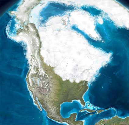
In the history of the Sierra Nevada there has been six recorded glacial periods: Matthes, Recess, Tioga, Tahoe, Sherwin and McGee. Each of these glaciations made their own impact on the Sierra Nevada as well as helping to form Yosemite National Park and Valley. Information about glacial maximums prior to the Tioga is imperfectly known because paths and evidence have been eroded away and wiped by younger glacial periods, but it can still be used to understand glacial features found today (Glazner, 2012). This period of last glacial maximum from 26,000 to 18,000 years ago has left the most present information for geologists to make observation and interpretations about Yosemite.
Glacier quite literally means "river of ice" taking on a visibly blue color as well as layering within, evidence of each winter’s accumulation. This may seem like a hypocritical statement, how can a solid ever behave like a liquid, but glaciers have found a way. The accumulation of snow year after year grows in density. As freeze and thaw happens, snow recrystallizes into ice, and when that ice is thick enough and persistent enough it will flow downhill under its own weight. This movement is referred to as plastic flow. Mary Hill describes this process as "each molecule gliding across its neighbor as the giant ice sheet shuffles along" (Hill, 2006). It takes approximately 50 meters of ice for enough pressure accumulation to allow the glacier to move of its own volition.
This miraculous process of glaciation took the simple V–shape of Yosemite Valley and turned it into the flat–bottomed vertical wall Valley that is seen today, unlike the usual U–shape that is most frequently the product of glacial impact. Yosemite Valley is a deviation from the norm because there was more than one glacial period in the area. A Sherwin–age glacier was almost surely responsible for the major excavation and shaping of Yosemite Valley within the Merced River canyon. The later glacial periods of Tahoe and Tioga did not influence the Valley nearly as much as the Sherwin. This previous glaciation allowed for joints to widened, rock to fracture and crumble, and waterfalls and cascades to erode back into alcoves and ravines. Thus the pinnacles and spires that seem so anomalous for a glacial valley actually had a million years to form (Huber, The Geologic History of Yosemite Valley, 2004). The differentiation between these glacial periods shows that each glacier behaved in a unique way, and left its own mark on the land.
As seen below, this image gives a wonderful understanding of what the many glacial periods in Yosemite National Park did to the quartz, feldspar, biotite, granite and hornblende of the Valley walls. The sharp, straight edge provides a steep cliff, the sudden drop permits spectacular waterfalls; the flattened bottom gives room for quiet lakes and marshes (Hill, 2006). At one time, a glacier did fill Yosemite Valley to its brim, but how do we account for the glacial erratics above the Valley rim. This is best explained by more than one episode of glaciation, creating such a unique geologic location.
Figure 2 (Huber and Roller, Bedrock Geology of the Yosemite Valley Area, 2000)
Glaciers themselves are very curious geologic process. They also produce a multitude of geologic markers that allow for the identification of a glaciated area. Horns are carved away by glaciers, while the same or multiple glaciers carve an arête on two sides. The cirque is an amphitheater shaped concave headwall that can hold the remains of a once great glacier. Terminal and lateral moraines form as glaciers move downward from higher elevation areas carrying rocks, debris and other assorted material. These are deposited on the edge and end of a glacier’s movement. The last predominant marker is a lake deposit in a depressed glacial basin, or a tarn. Abundant peaks, arêtes and horns stood above the late Pleistocene ice sheet of Yosemite National Park. These trim lines and glacial landforms of glacial striae and boulder accumulation define ice–flow direction, geologic evidence for the work of glaciers within the Park (Wahrhaftig, 1990)
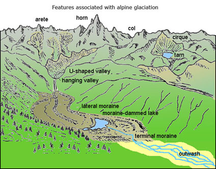
Figure 3 An apt understanding of basic glacial features (Cafe, 2012)
Bedrock structures that affected the formation and shaping of many Yosemite features are that of jointing. Most specifically sheet jointing formed through the process of exfoliation, like the peeling of an onion. As exfoliation happens, sheets of granite are shed away, and the dome shaped of many Yosemite features like Half and Lembert Dome was created. Glacial polish, another visible marker seen on many rock features in Yosemite allows for a better understanding of which glacial period polished a specific areas as well as their possible age. "The deep weathering of the glacier polish found on the steeper slopes of the Nevada Fall area and on the low ridge that extends east from Liberty Gap into Little Yosemite Valley indicates that it is pre–Tioga in age" (Schaffer, 1977). If the Tioga age glacier had made it this far to the polish, the present day polish would have been obliterated or at least smoothed down much more so than is seen today.
Different trim lines as well as striations and nunatacks give geologists a good understanding of the glacial stages that Yosemite Park underwent throughout history. During the era of the Tuolumne ice filed, nunatacks or islands in the ice (Glazner, 2012) were never run over by glaciers. These outcrops show a visible trim line in Tuolumne Meadows, which gave way to the beautiful Cathedral, Unicorn and Mt. Lyell peaks.
The glaciation of Tuolumne Meadows and Hetch Hetchy was not as restricted as that of the Merced River and Yosemite Valley. This Tioga age glaciation, though much less in size than the Sherwin had an ice field of much greater proportion. This ice field was three times larger spreading out over broad reaches producing "roches moutonnées" (Hill, 2006). These rounded rocks are gradually smooth and rise on one side, while the opposite side is irregular, angular and plucked much like this image of Lembert Dome below.
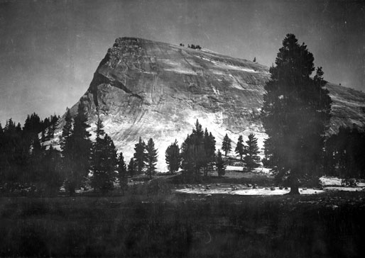
Figure 4 Lembert Dome, a northeastern view from Tuolumne Meadows (Gilbert, 1908)
In regards to Lembert Dome the downstream side was smoothed and the up-glacier side was plucked giving it its visible teardrop shape. The striations in the rock surface of Lembert dome show ice motion. Though Lembert dome looks smooth from a distance, up-close there are plenty of handholds and rough patches. Needless to say, that still makes this mostly granite face a very difficult climb.
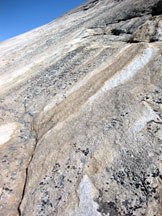
Figure 5 Zoomed in portion of the Lembert Dome Face (Klapperich, 2012)
Another stunning feature of Yosemite National Park, and evidence that it was a glacially shaped area is the many leaping falls and hanging valleys. When the Sherwin glacier shaped Yosemite Valley, it carved the chasm of the now present valley. Smaller tributaries entered in from the sides of the valley meeting the Sherwin glacier at its uppermost level. Once the glacier melted away, there were thousands of feet between the past tributaries and the valley floor. This left what is known as a hanging wall, many of which had waterfalls to make the breathtaking leap to the valley floor. The two most well known and visible hanging walls and leaping falls in the Valley are Bridalveil and Yosemite Falls.
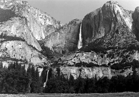
Figure 6 UPPER YOSEMITE FALL now leaps from the hanging valley of Yosemite Creek. In the not–too–distant geologic past its water cascaded down through the prominent ravine to the left. The spire of Lost Arrow is visible upward and to the right of Upper Yosemite Fall. The middle tree–covered bench at left marks the approximate upper limit of the Tioga–age glacier in Yosemite Valley. (Huber and Roller, Bedrock Geology of the Yosemite Valley Area, 2000)
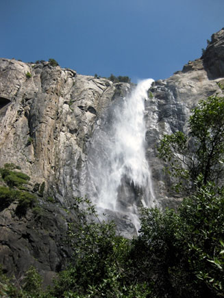
Figure 7 Bridalveil Falls in Yosemite Valley (Klapperich, 2012)
All of these magnificent geologic formations would not be present if the Tahoe, Tenaya, and Tioga glaciations (Schaffer, 1977) had not made their way through Yosemite National park 85,000 – 10,000 years ago. Not only did glaciation carve out beautiful Yosemite Valley, but also produced outstanding formations like Lembert and Fairview Dome and well as El Capitan. There is no one specific understandings why the earth cools and glaciers that were once present to form these great features no long exist. One thing is for certain, whatever the force, it was a very powerful one. "If the cloud cover, today at 31% of the Earth’s surface increased to 36% it has been estimated that the temperature could drop 7°F, enough to trigger a new ice advance" (Hill, 2006). The potential for another glacial period is ever pending the question is when?
Works Cited
Cafe, G. (2012, June 5). Introdution to Geology. United States of America: Gavilan College .
Gilbert, G. (1908). Lembert Dome. Yosemite National Park, California, United States of America: United States Geologic Survey Photographic Library .
Glazner, A. (2012, May 22). Glaciers, Granite, and Moraines of the Eastern Sierra Nevada. SNARL Lecture Series.(SNARL, Compiler) Mono County, California, United States of America: Sierra Nevada Aquatic Research Laboritory.
Hill, M. (2006). Great is Granite, Days of Ice. In M. Hill, Geology of the Sierra Nevada (pp. 196–202 ,291-319). Berkeley, California, United States of America: University of California Press.
Hodges, C. A. (1999, May 05). Half Dome. California, United States of America: United States Geologic Survey.
Huber, N. K. (2004, January 13). The Geologic History of Yosemite Valley. Yosemite National Park, California, United States of America: United States Geologic Survey.
Huber, N. K., & Roller, J. A. (2000, September 18). Bedrock Geology of the Yosemite Valley Area. Yosemite National Park, California, United States of America: United States Geologic Survey.
Klapperich, S. Lembert Dome Blow–up, Bridalveil Falls, Yosemite Falls. Private Photographs, Yosemite National park, California.
Lutgens, F. K. (2011). Glaciers, Deserts, and Wind. In F. K. Lutgens, Essentials of Geology (11th ed., pp. 129–148). United States of America: Prentice Hall.
NASA Visible Earth. (2012, June 11). Earth – Last Ice Age. Animation of Last Ice Age. Bloomington, IN, United States of America: National Aeronautics and Space Administration.
Schaffer, J. P. (1977). Pleistocene Lake Yosemite and the Wisconsin Glaciation of Yosemite Valley. California Geology, 30 (11), 243–248.
Varner. (2009). North America, Pleistocene Glacial period, 0.026 Ma (26000 years ago). Pleistocence Epoch of the Quaternary Period. Arizona, United States of America: Northern Arizona Univeristy.
Wahrhaftig, C. (1990, October 16). Late Pleistocene Glaciation of Yosemite National Park and its Impacts. A Global Issues Symposium. Yosemite National Park, California, United States of America.