Geology and Natural Heritage of the Long Valley Caldera
Death Valley, CA: Alluvial Fans in the Making
Muhammad Shahir Muttaqin Mohd Fauzi
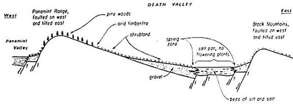
Figure 1: Simplified cross section of Death Valley [Hunt,1975]
Abstract
This study explains why tectonic environment is often interrelated with alluvial fans and how does it affect the formation of the fans. Death Valley is situated in the Basin and Range system, which is associated with the forces of pulling apart the North American continent resulting from tectonic activities. Even though tectonic environment is one of the many aspects of alluvial fans formation, other aspects also play an equal role for the formation. The purpose of this writing is to summarize the studies and knowledge that scholars currently have about alluvial fans especially in Death Valley. Particularly for the last two decades, alluvial fans are one of the landforms that have been studied very rigorously, mainly for its distinct geomorphology and geologic history. Alluvial fans are distinct ancient landforms that form a segment of a cone that radiates downslope from the point where the stream leaves the source area and are made up of deposit materials [Bull 1977]. There are three ideal conditions for alluvial fans to be created [Blair and McPherson 1994] discussed in the later part of this paper. It would also help to remember the distinguishing aspect of alluvial fans and pediments. While pediments are formed by erosional process, alluvial fans are created in a depositional environment by constructional processes [Bull, 1977].
Introduction
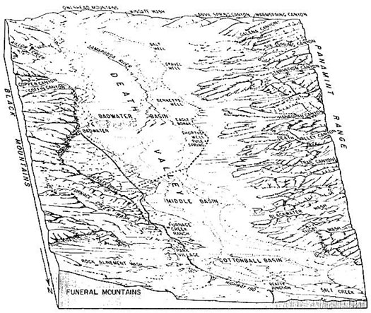
Figure 2: The figure shows a sketch of Death Valley from a bird's eye view [Hunt, 1975]
Death Valley is arguably one of the few places that never cease to leave an emotional impact on almost everyone who visits it. To some the valley is a just unbearably hot, unnerving, and dry salt bed that lies below sea level, surrounded by very steep mountains in almost every corner. Others might think that the place is mind-blowing, full of stories in its most glorious days and mysteries waiting to be disentangled one by one. Those who were lucky enough to witness the beauty of the valley before their eyes usually could not help but wonder how it became what it is. Death Valley is world renowned for its colorful and complex geology, attracting scholars and visitors to come and visit the natural geologic museum. The valley is located in Eastern California and situated within the Mojave Desert. Death Valley is also famous for its distinctive landforms. Some of the Death Valley landforms that have always been the talk of Earth science enthusiasts are alluvial fans, salt flats, basins and valleys, canyons, the Devil’s Golf Course, mountains, sand dunes, Devil’s Hole, springs and seeps, and the list goes on. However, the purpose of this paper is to discuss the geomorphology, sedimentology and dynamics of alluvial fans which has caught the interest of the author upon visiting the valley.
For its extreme settings, Death Valley features the lowest, driest, and hottest locations in North America, receiving less than two inches of rain per year. In 1913, a temperature of 134°F was recorded in Death Valley as one of the highest temperature ever recorded on Earth, coming second after the great Sahara Desert in Libya in 1936 with 136°F [USGS Death Valley website, 2004]. As if that was not enough, the lowest point in the United States is also located in the valley, at 282 feet (86 meters) below sea level. In the 1920s, Death Valley’s significant scientific importance was first brought to the attention of the National Park Service and later was announced as a national monument on February 11, 1933 by President Herbert Hoover [Death Valley Visitor Guidebook]. In present days, the national park is made up of nearly 3.4 million acres, housing some of the most magnificent ancient landforms. Death Valley is bounded by Black Mountains on the east side and Panamint Range on the west side of the valley [Implied from Figure 2]
Geological Settings of Death Valley
For centuries, Death Valley has become one of the most famous spots for geologists to come and study the desert geomorphology in the Basin and Range province of North America. Extreme climates of the region set Death Valley apart from the temperate and tropical environments in a way that Death Valley receives very minimal rainfall annually as compared to the latter. By definition, any area that receives less than 10 inches of precipitation with high evaporation rate is considered a desert [USGS Death Valley website, 2005]. The dry aspect of the region is due to most of the moisture from clouds having already been precipitated on the western side of the mountains, causing the eastern side of the mountains receiving only dry "rainshadow." In between Death Valley and the ocean, there are four major mountain ranges, each one adding to the intensity of the "rainshadow" effect. On the other hand, the hot climate aspect of the valley is caused by the depth and shape of Death Valley. The long and narrow basin with high walls and steep mountain ranges trap heat from escaping the valley. Also, very sparse vegetation allows sunlight to continuously heat the desert surface. As heated air rises, it is trapped by the high valley walls, cooled and recycled back to the valley floor. This continuous process mainly contributes to the extreme summer temperatures in the valley.
Faulting, Uplift, and Subsidence
Remarkable examples of faulting, alluvial fans, shorelines of ancient lakes, weathering and erosion of brightly colored sediments, and a history of western frontierism is presented in the harsh landscape of Death Valley. The dramatic geological landscape of Death Valley is also affected by the location of the region itself. Because the region is located near the western edge of cratonic North America, plate boundary effects that can be dated back to the Proterozoic era can be recorded. Some of the boundary effects include rifting and the development of the passive margin during Late Proterozoic, crustal shortening and Sierra Nevada magnetism largely during the Mesozoic, and crustal extension and magnetism during the Late Cenozoic [Miller, 2005].
Death Valley is a part of the Basin and Range system, which is a large region of "regionally corrugated, angular topography of high relief in the western Cordillera" [Eaton, 1982]. Basin and Range is associated with the forces of pulling apart the North American continent that created a series of several hundred mountain ranges and valleys. Stretched from the Wasatch Fault along the Wasatch Mountains in central Utah all the way to the Sierra Nevada in eastern California, the Basin and Range province includes part of Mexico, Texas, New Mexico, Arizona, California, Nevada, Utah, Oregon and Idaho. According to Eaton [1982], poorly sorted gravel that slope smoothly basinward marks the range flanks. Eaton also states that low fault scarps that are parallel to the range front faults and by alluvial fans at the mouths of canyon draining the ranges interrupted the flanks. For the last 25 million years, the Earth’s crust within the Basin and Range Province has been stretched and pulled apart to up to 100% of its original width. It is also remarkable that the stretching of the Earth’s crust in the Basin and Range Province is still happening even today. Large faults, mainly normal faults, are created as the crust thinned and cracked due to the constant stress applied to the crust [USGS Basin and Range website, 2004]. These faults allow large–scale vertical movements of the Earth’s, thus marking the boundaries between the down–dropped "Basins" (low valleys) and the up–thrown "Ranges" (steep and very high mountains) that make up the Basin and Range physiography. The lowest point of the Basin and Range region is Badwater Basin with the elevation of 282 feet (86 meters) below sea level, while the highest point of the region is the Telescope Peak at 11,043 feet (3,366) above sea level.
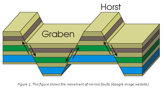
Figure 3: This figure shows the movement of normal faults [Google image website]
Weathering and erosion impact the rocky ranges. The process of erosion by water, ice, wind and other erosional agents is constantly reducing the mountains and filling the basin with large volumes of sediments. According to USGS website [2005], the sediments that are accumulated in the valley consist of boulders, gravel, sand, silt, and clay. The sediments are carried downhill by the force of gravity and water which also forms the magnificent landscapes of Death Valley and can easily be seen along the region. The processes involved in the formation of the landform will be discussed in great details in later sections of this paper. Despite of the continuous sediment fill into the region, Death Valley has not filled up due to the effect of buoyancy. As mass is being added, the valley sinks down and the mountains on both sides of the valley are also reacting by being uplifted.
Formation of Alluvial Fans
Unusual environment settings and location of the Death Valley have enabled geomorphologists to witness the many magnificent landforms within the region that were created by natural processes throughout geologic time. Death Valley has always been a classic spot for geologists to unravel the mysteries behind the glorious geomorphology of Death Valley. A lot of the geomorphology in Death Valley can be easily seen by the naked eye, but they cannot be necessarily easily understood per se.
Blair and McPherson [1994] define alluvial fans as "a prominent landform type commonly present where a channel emerges from mountainous uplands to an adjoining valley." Due to the ease of access and exposures, alluvial fans in desserts have conventionally been the most studied even though alluvial fans can occur in possibly every type of global climate. Resembling a cone segment radiating downslope from a point where a channel emerges from upland, alluvial fans are typically made of sedimentary deposits of different sizes and types [Bull, 1977]. Looking from a bird’s–eye view, alluvial fans generally are in a semi–circular shape, while cross–section profiles of the fans show a plano–convex geometry. Correspondingly, from a research done by Anstey [1965], alluvial fans ordinarily have a radii range of 0.5 to 10.0 km from the mountain front.
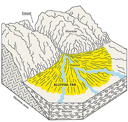
Figure 4: The figure shows a cross section of an alluvial fan system [The San Bernandino Sun website,2011
Based on the on–site observations that the author has done, alluvial fans have course–grained, poorly sorted, and unconsolidated deposits almost unvaryingly due to three major interpretations. First being the relative short transport distance of the sediment from its source, mass wasting processes initiated by high relief, and lastly the flow carrying capacity that decreases very rapidly as water runs downslope [Blair and McPherson, 1994]. From very small debris cone to large fluvial fans, it is tacit that a continuum depositional process needs to occur in order for alluvial fans to be created [Saito and Oguchi, 2005]. As most other landforms take a very long time to develop, so do alluvial fans as a continual process of sediments depositions need to happen before alluvial fans can visibly be seen which might take up to thousands of such occurrences and perhaps several thousand years to acquire the alluvial fans that we get to see today. The age of an alluvial fan can be studied by radiocarbon dating of the sediments in the alluvial fan. According to the principle of superposition, sedimentary layers are deposited in a time sequence, with the oldest on the bottom and the youngest on the top, thus theoretically an accurate age of an alluvial fan can be obtained by chemically dating the bottom–most layer of the fan.
To go deeper into this matter, Blair and McPherson [1994] also stated that there are three conditions necessary that are essential for the development of alluvial fans. First, it is important that a topographic setting where a channel can flow from upland to lowland be unconfined. Marginal to uplifted structural blocks bounded by faults with significant dip–slip is the most typical setting for alluvial fans. A clear example for this is the Basin and Range Province where tectonic activity has developed the upland and adjoining lowland configuration. Second, the basin drainage basin must have an adequate sediment production. Usually this can be achieved with the presence of relief and continual weathering of rocks, given adequate time. Lastly, high water discharge created by infrequent intense precipitation as a mode of transport for the sediments. Flashfloods, rock falls, rock avalanches, gravity slides and debris flows are some of the example of the prominent process associated with the transport of sediments for alluvial fans development.
Alluvial fans key morphologic features are the drainage basin, feeder channel, apex, incised channel, distributary channels, intersection point, active depositional lobe, and headward–eroding gullies [Blair and McPherson, 1994] (Figure 5). Sediments and water are discharge from an upland area drainage basin, which naturally characterized by very steep slopes especially in desert settings and have up to five short ephemeral channels. Additionally, the topography and shape of alluvial fan drainage basins make them particularly prone to generating catastrophic flash floods, which also aid the formation of alluvial fans. A mountainous desert like Death Valley provides ideal conditions necessary for alluvial fan development for its necessary topography and tectonic history.
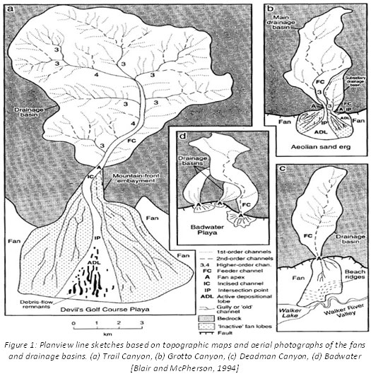
Figure 5: Planview line sketches based on topographic maps and aerial photographs of the fans and drainage basins. (a) Trail Canyon, (b) Grotto Canyon, (c) Deadman Canyon, (d) Badwater [Blair and McPherson, 1994]
Conclusion
Alluvial fans develop from constructional process of sediments deposition that comes from the result of destructional process from adjacent mountains. These constructional and destructional process complement each other in a way that what would be the product of destructional process of one thing can become the source for a constructional process of another. Death Valley has shown us a glimpse of a whole lot of interesting processes that might have happened throughout the geologic years in the Basin and Range Province. The richness of the region should always be preserved and left undisturbed so that the legacy of the superb geomorphology can always be celebrated for centuries.
Works Cited
Blair and McPherson. Geomorphology of Desert Environments. London: Chapman & Hall, 1994.
Bull, William B. The alluvial–fan environment. SAGE Journals (1977).
Eaton, Gordon P. THE BASIN AND RANGE PROVINCE: Origin and Tectonic Significance. Annual Reviews Earth Planet Science 1982: 32.
Hunt, Charles Butler. Death Valley: Geology, Ecology, Archeology. London: University of California Press, 1975.
Miller, Marli Bryant. Geological landscapes of the Death Valley region. (2005): 14.
Mosaic Canyon. n.d. website.
SBSUN. Debris–Flow Areas, Alluvial Fans and Unpredictable Floods. 2011. website.
USGS. Death Valley’s Incredible Weather. 13 January 2004. website
Geologic Provinces of the United States: Basin and Range Province. 13 January 2004. website.