Geology and Natural Heritage of the Long Valley Caldera
Tessellations in the Eastern Sierra
Elizabeth Davis
Abstract
In the Eastern Sierra Nevada, landforms formed by fracture tessellations occur in both Death Valley’s Badwater Basin and the Owens River Gorge. Badwater Basin’s salt playa is a sedimentary landform of salt and mud layers, deposited by evaporating water, cracked by either thermal or dessication stresses, and enhanced by efflourescent crystallization. This creates a tessellation of buckling, geometric salt cracks. The Owens River Gorge is a volcanic landform created after the deposition of the Bishop Tuff Volcanic Tableland cooled and fractured into roughly hexagonal vertical joints and rosettes. The Owens River cut the gorge, revealing the regular jointed walls and rosettes
Introduction
Nature’s tessellations have captured the attentions and imaginations of humans for thousands of years. Patterned ground, regular fractures, and other aesthetic phenomena are not anomalies – the earth is littered with small areas of repeating patterns. The Eastern edge of the Sierra Nevada is no exception. This paper explores the geological foundations for geometric tessellations in two distinct areas – the cracked salt playa of Badwater Basin in Death Valley, and the columnar joints in the walls of the Owens River Gorge. Unfortunately, this paper does not explore the specific physical and chemical properties that regulate polygonal fracturing, but rather focuses on the processes and landforms allowing these patterns to occur.
I: Badwater Basin, Death Valley
The first example of polygonal cracking is the salt playa of Badwater Basin in Death Valley National Park, Nevada. Flat layers of salt and mud are deposited on the floor of the basin. Then, cracks form in the surface of the salt layer, creating tessellations of large polygons across the basin floor.
Landforms
The Badwater Basin salt playa of Death Valley is a 200 square mile playa of crystallized salt, which cracks regularly into rough polygons of about 1.5 m in diameter ("Salt Flats," 2012). The floor of the basin is flat and extends horizontally up to the alluvial fans that mark the edges of the ranges on either side of Death Valley. During May of 2012, the salt crystals on the ground were white and tan, and protruded enough to crunch when stepped on – up to 1 cm tall. On the salt were numerous short, fine hairs of crystallized borax. The ground was homogeneous in texture and composition. The cracks in the salt ranged from hairlines to gaping 3–4 cm wide. Around the larger crack openings, the edges of the floor layer formed a 4–5 cm tall ridge around the opening (see photo below). Through these large cracks, the underside of the salt layer was visible: below the crystallized top crust hung a brown layer of thicker mud. Other hairline cracks were filled with very white crystallizations of salt. Past chemical analysis of the floor has shown that 95% of the salt deposits are sodium chloride, but calcite, gypsum, and borax are also present ("Salt Flats," 2012).
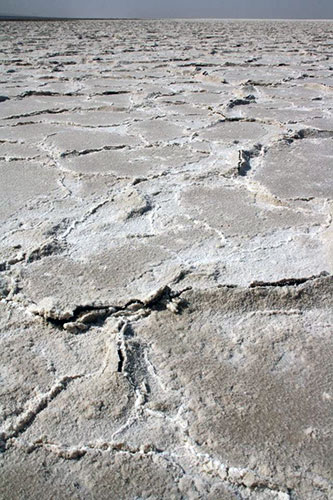
Figure 1: Polygonal salt crack: macro texture and color. Photo by Elizabeth Nixon, 05/2012
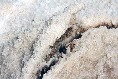
Figure 2: Polygonal salt crack: micro texture and color. Photo by Elizabeth Nixon, 05/2012
Processes
This observational information has lead scientists to form a commonly–accepted view of the processes that formed the salt pan in Badwater Basin. The formation of a salt flat requires a source of salts, a non-draining basin, and a climate where the evaporation rate exceeds the precipitation rate ("Salt Flats," 2012). Death Valley has all three of these requirements. The source of salts is the 9,000 square mile drainage system that runs off the Panamint Range to the West and the Black Mountains to the East (Death Valley geology field trip, 2004). Highly–soluble salts from rocks and earth dissolve in rainwater as it falls, running into Death Valley. The elevation of Badwater Basin is 282 feet below sea level, making it the lowest point in the contiguous United States. This means that there is no way for water to flow out of it. All the water and salt ions stay in the basin. The average annual rainfall is only 1.9 inches, while the average annual evaporation rate is 150 inches, meaning that all this runoff water will evaporate, precipitating all the salts on the basin floor. This process occurred on a large scale during the Holocene, when a wet climate led to the filling of Death Valley with a 30 ft deep lake. Eventually the rainfall declined, and the water all evaporated, leaving significant salt deposits. Today the process occurs on a smaller scale, when large rainstorms temporarily but periodically shallowly flood the basin floor, re–dissolving and re–depositing some of the salts.
The process behind the cracked pattern of the salt is more complicated. A study from Southeast Arabia describes in detail the processes in that area (T. M. Goodall et al. 1998). Though different in scale, those salt basins are somewhat similar in landforms and water availability to those of Death Valley. Goodall and his colleagues suggest that salt deposits form in two distinct ways—through the precipitation process described above and through efflorescence. Efflorescence occurs on a small scale, when brine drops clinging onto sedimentary grains deposit salts onto those grains as the brine evaporates. They suggest that while the brine in the basin is evaporating, supersaturation of the salts in the brine causes sheets of halite (sodium chloride) crystals to precipitate in "rafts" onto the surface of the brine. As these grow larger, they become too heavy and sink to the floor of the playa, leaving about 3 cm of loose halite rafts on the bottom, forming the salt crust. These planar sheets with individual crystals might be flattened in a few weeks by desert dew and blowing sediments. The long–term accumulation of these sediments is what causes the brownish discoloration of the salt crust.
The polygonal cracks are formed when the volume of the salt crust decreases, either by thermal contraction or dessication (water removal). Dessication is the preferred method of explanation for the polygonal cracking of mud and clay playas, but it is highly disputed as the explanation for salt crusts, primarily because salt is easily soluble. Goodall et al. suggest that thermal shrinkage works the same way as can be seen in hexagonal fractures and columnar jointing in basalts, but offer no suggestion of which theory is more correct. (Section II of this paper explores more deeply the volcanic thermal contraction that causes vertical jointing.) However, they confirm that after fracturing occurs, efflorescent halite forms in the cracks, causing the white salt deposits in the hairline cracks, and causing the vertical buckling and expansion of the edges of the larger cracks.
This process occurs homogeneously across the surface of the Badwater salt playa, causing the repeating pattern of polygonal cracks.
II: Owens River Gorge
The Owens River Gorge displays another example of polygonal fracturing in the Eastern Sierra Nevada, this time volcanic in origin rather than sedimentary. The formation of the gorge occurred in three stages: deposition of the Volcanic Tableland, welding and cooling of the volcanic material, and river erosion which cut the gorge. The cooling of the tableland is where the polygonal fracturing occurred—leaving huge vertical joints on the gorge walls, and stunning rosette patterns on the rock faces.
Landforms
The landforms in the Owens River Gorge are defined by the specific jointing displayed there. The gorge is cut essentially vertically, and is relatively narrow – about 50m from rim to rim. The walls of the gorge exhibit columnar jointing and rosettes. In May 2012, the columns appeared to have between four and seven sides, and were highly variant in length. They appeared to have diameters between 0.25 and 1.5 meters. The rosettes were series of fractures extending out in a half circle from one point about two thirds of the way up the wall. Below the point, there was typically a vertical fracture. Above the rosettes, there were often piles of tephra on the surface of the volcanic tableland.
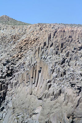
Figure 3: Columnar jointing in Owens River Gorge. Photo by Elizabeth Nixon, 05/2012
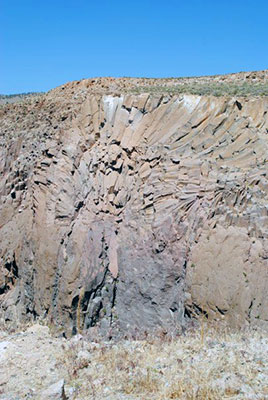
Figure 4: Owens River Gorge Rosette. Photo by Andrea Balzano, 05/2012.
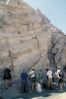
Figure 5: Owens River Gorge Jointing, with people for size comparison. Photo by Elizabeth Nixon, 05/2012.
Processes
As mentioned above, the Owens River Gorge was created in three different stages. The first of these was the deposition of the Volcanic Tableland that holds the gorge. This Tableland, made up of the Bishop Tuff, erupted as first ash fall tuff, and then a pyroclastic flow, from the Long Valley caldera around 760 million years ago (Bailey et al., DATE). The Bishop Tuff is a relatively homogeneous, rhyolitic sheet, though probably was distributed during two adjacent eruptions, or "pulses." The Owens River Gorge shows that the bottom layers of ash fall were highly compressed by the weight and temperature of the volcanism on top of them. This weight welded the tuff to its current solid, consolidated, homogeneous texture.
It is widely accepted that the cooling process of the welded tuff created the vertical jointing and rosettes that are displayed on the sides of the valley. However, the exact mechanisms of this process are not well defined, especially for this specific location. In other areas of the world, much research has been done on vertical jointing in lavas and welded tuffs, and a basic model has been created. In ideal situations, lava or tuff will be of uniform composition and density, will have a flat surface, so will cool evenly. When lava or tuff cools, it contracts, and therefore it would contract evenly (Nishiwaki, 2009). The figure below demonstrates how this contraction would cause regular fractures. Ideally, these fractures would be regularly spaced and organized in the shapes of regular hexagons, creating a tessellation of linked hexagons that could be seen from above. According to Nishiwaki, the rosette pattern occurs when lava or tuff comes from a distinct opening and has a domed cooling surface.
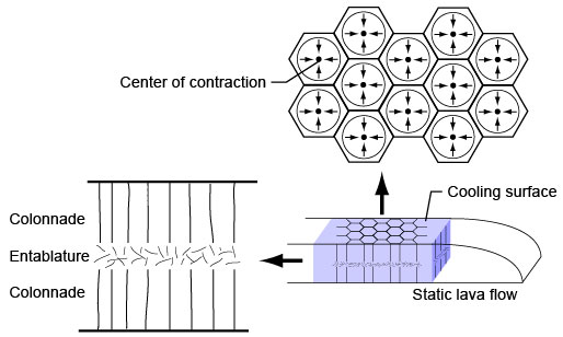
Figure 6: Ideal model for columnar jointing. (Nishiwaki, 2009).
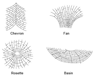
Figure 7: Columnar jointing patterns. (Nishiwaki, 2009).
Budkewitsch and Robin proposed a more subtle model by analyzing columnar jointing in several locations across the world, including Devil’s Postpile in California, and excluding the Owens River Gorge. However, their models are designed to be applicable to other global locations (Budkewitsch and Robin, 1994). They suggested that a conductive–convective heat transfer mechanism was responsible for columnar jointing, and that uneven cooling lead to non-hexagonal shapes, like five– and seven–sided columns. Their model also suggests that jointing begins as cracks at the edges of the cooling flows, and the cooling causes new cracks to form, moving inwards, perpendicular to the isothermal surfaces.
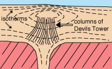
Figure 8: The isotherms in the volcanic table surrounding Devil’s Tower, another example of columnar jointing. ("Columnar Jointing," nd.)
The diameter of the column is inversely proportional to the rate of cooling, so the faster the cooling, the more often the solidified lava or tuff cracks vertically and the smaller the diameter of the columns. This cooling process created the columns and rosettes visible on the side of the gorge – the columns cooling regularly in the volcanic tableland, and the rosettes forming when material that had moved up through a joint cooled in radial directions over the top. The joints are visible because the Owens River, starting on top of the tableland, slowly eroded the sides of the gorge to its level today.
Conclusions
Though geometric patterns in Death Valley and the Owens River Gorge are created through well–understood and relatively simple geologic processes, the mechanisms that cause the shape of the fractures are much more complex, and still under scientific debate. Though the components of the Death Valley floor are sedimentary, and the components of the Owens River Gorge are volcanic, the materials both have similar fracturing effects under thermal or water–driven stresses.
Works Cited
Badwater, Death Valley National Park. The American Southwest: California. N.p., n.d. Web. 11 June 2012 website.
Bailey, Roy A., Dalrymple, G. Brent, and Lanphere, Marvin A. Volcanism, Structure, and Geochronology of Long Valley Caldera, Mono County, California. Journal of Geophysical Research 81.5 (1976): 725–44. Print.
Budkewitsch, Paul, and Robin, Pierre-Yves. Modelling the Evolution of Columnar Joints. Journal of Volcanology and Geothermal Research 59 (1994): 219–39. Print.
Columnar Jointing. Volcano World. Department of Geosciences, Oregon State University, n.d. Web. 10 June 2012. website
Death Valley National Park Virtual Geology Field Trip. 2004. 11 June 2012 website.
Goodall, Timothy M., North, Colin P. and Glennie, Kenneth W. Surface and Subsurface Sedimentary Structures Produced by Salt Crust. Sedimentology 47 (2000): 99–118. Print.
Nishiwaki, Hirotishi. Columnar Joints and Lanscapes. Introduction to the Landforms and Geology of Japan. GLGArcs, 2009. Web. 10 June 2012. website
Salt Flats. National Parks Service. National Parks Service, 30 May 2012. Web. 11 June 2012. website