Geology and Natural Heritage of the Long Valley Caldera
National Audubon Society v. Superior Court and Its Applications in the American Southwest
Sarah Bauer
Abstract
Information on the events leading up to the case National Audubon Society v. Superior Court is provided, as well as basic facts and figures on current water usage in both Los Angeles and the Southwest in general. A geologic history of Mono Lake is critical for comparison to Southwest water sources such as the Colorado River, Lakes Powell and Mead, and the San Joaquin River. The case and its decision are described in detail, followed by commentary on water issues in the Southwest including claims to sources and causes of shortages. Finally, there is a discussion on whether the precedent set by Audubon is applicable to other water sources in the Colorado Basin states.
Introduction
The case briefing for Audubon [1983] explains that in the mid-nineteenth century, the city of Los Angeles experienced massive expansion as news of gold discovery swept across the country. As a result of the population boom, the city’s demand for water quickly outgrew its supply and it became necessary to look elsewhere for water sources. The mayor of Los Angeles bought land in the Sierras and used the Owens River as a supply. An aqueduct from the Owens Valley to LA was completed in 1913 and Owens Lake was completely dry 13 years later, thus beginning California’s "Water Wars" with Owens Valley residents. By the 1940’s, the Los Angeles Department of Water and Power was granted permits to draw from Lee Vining, Walker, Parker, and Rush Creeks, four of the five tributaries of Mono Lake. A second aqueduct was necessary to transport the volume of water, and by the 1970’s LADWP was also taking surface water from the Mono Basin and ground and surface water from the Owens Valley, effectively quadrupling their take [all from Audubon, 1983]. The Mono Lake Committee formed shortly after with the intention of preserving the lake by fighting for the reduction of water diversions by LADWP [Hamburger, 2012], laying the groundwork for the California Supreme Court case National Audubon Society v. Superior Court.
From 1982 to 2007, water demand in LA has remained fairly consistent, despite a population increase of 1 million people, as seen in Figure 1 [Villaraigosa, 2008].

Figure 1. Figure reproduced from Villaraigosa. [2008] (exact reproduction)
According to a report by LA Mayor Antonio Villaraigosa [2008], however, the city then experienced shortages from each of its water sources due to low snowpack in the Eastern Sierra Nevadas and increased environmental concerns, including "mitigation and enhancements" in both the Owens Valley and Mono Lake Basin. The L.A. Times [2012] reports that conservation efforts were introduced during a drought beginning in 2009 and remain in place despite the drought officially ending one year ago. As of May 8 of this year, use is on the rise again and up 3% from 2011 [L.A. Times, 2012].
Los Angeles is a microcosm for the market for water in the entire Southwest; cities in the region are quickly outgrowing their supplies and mandating water use restrictions while searching for other sources and attempting to secure those they already have [Kunzig, 2008]. In the coming years, it is likely that the Colorado River and Lake Mead will become spots of contention. The Colorado River provides water to 30 million people in 7 states [Kunzig, 2008]. According to a National Geographic article written by Robert Kunzig [2008], Denver, Las Vegas, Tucson, Phoenix, Los Angeles, San Diego, and Albuquerque all depend on it and Lakes Mead and Powell as major water sources. All three are currently experiencing a drought, destroying local ecosystems and forcing states to negotiate their takes [Kunzig, 2008]. The San Joaquin River is also suffering from California’s repeated water diversions and has recently become the center of a debate on whether the addition of another dam will provide enough benefits to offset environmental costs [U.S. Fish and Wildlife Service, 2006]. With the precedent of National Audubon Society v. Superior Court having been set, it may be possible to infer the decisions that must be made about such sources in the future.
Background Information
Mono Lake formed at least 760,000 years ago as a result of an eruption in Long Valley [Hill, 2012]. The explosion partially emptied its magma chamber and the roof collapsed and sank in on itself, forming what is known today as the Long Valley Caldera [Hill, 2012]. The eruption consisted heavily of pyroclastic flow, covering much of the area in a massive layer of ash and pumice [Hill, 2012]. The subsequent landscape is a classic example of rhyolitic features, indicating that the volcano contained silica-rich magma and therefore led to an explosive eruption [Hill, 2012]. The tuff from this eruption is referred to as Bishop Tuff, and large outcrops of it are visible in both the Owens Valley and Mono–Inyo Craters [Hill, 2012].
The lake lies in the Mono Basin and therefore has no outlet to the ocean [Hill, 2012]. The Basin is just outside of the Long Valley Caldera, its border to the south, and is also flanked by a fault of the Sierra Nevadas to the west and Bodie Hills on the north [Hamburger, 2012]. Its tributaries, though consisting of potent freshwater, still do contain salts dissolved in solution [Rupp, 2012]. Once that water reaches the lake, it evaporates and leaves the salt behind, leading to both high salinity and alkalinity and creating harsh circumstances for any ecosystem [Rupp, 2012]. The bed of the lake consists of ash layer from the Long Valley eruption, though recent research indicates it is possible that there are sediments beneath, meaning that the lake was once part of a much larger body of water which spread into parts of Nevada [Hill, 2012]. Mono Lake is still an active area within the Mono–Inyo Craters with an eruption as recent as 350 years ago; Paoha Island and Panum Crater are both evidence of recent volcanic activity [Hill, 2012].
In the 1970’s, climate specialist Scott Stine of California State University found dead, tufa–covered remains of cottonwood and Jeffrey pine trees along the shorelines which had been exposed after LA’s water diversions [Kunzig, 2008]. Tufa is a type of limestone created from precipitated calcium carbonate and is quite common at Mono Lake; its saline water is conducive to calcium carbonate precipitation [Hamburger, 2012]. He theorized that the trees grew during a previous drought which had exposed that same lakebed and died when the water level rose again [Kunzig, 2008]. LA’s water takings then lowered the lake surface to the same place, exposing the old stumps [Kunzig, 2008]. He considers the previous, natural drought to be "severe and long–lasting," and it is concerning that water diversions replicated such conditions within a few years [Kunzig, 2008].
Unlike Mono Lake, Lakes Mead and Powell are both man-made reservoirs fed by the Colorado River [U.S. Department of the Interior website, 2012]. They still do, however, support native species and were built in natural canyons [Interior, 2012]. Lake Powell was created by flooding Glen Canyon, a canyon formed by erosion from the Colorado River [Interior, 2012]. The canyon was flooded using the Glen Canyon Dam, a controversial project because of its negative impact on the ecology of the Colorado River [Glen Canyon Institute website, 2012]. The Glen Canyon Institute [2012] provides the same type of grassroots support as the Mono Lake Committee; it is currently aiming to restore the canyon and promote free flow of the Colorado River. It notes that, like the dams one can view in the tributaries of Mono Lake, Glen Canyon Dam is designed to trap silt from the heavily sedimented Colorado River [Glen, 2012]. This trapped sediment is not being dredged properly and is filling up the canyon, inviting the possibility of blocking the outlets for water and reducing the flow of the river [Glen, 2012]. Glen Canyon, and therefore Lake Powell, is constructed of extremely porous sandstone which allows for major loss from seepage and accounts for 6–8% of the flow from the Colorado River [Glen, 2012]. This combination of outlet block and seepage loss can have a huge negative impact on the wildlife which the river supports [Glen, 2012].
Lake Mead, unlike Lake Powell, consists of several flooded basins including Boulder, Virgin, Temple, and Gregg basins [Interior, 2012]. The Muddy River Inlet and Virgin River Basin have the potential to flood when the water level is high enough but are currently dry [Interior, 2012]. Also unlike Lake Powell, the majority of Lake Mead’s water comes from snow melt in various mountain ranges, and decreased snowfall within the last decade has led to it being filled to less than 40% of its capacity [Interior, 2012]. Lake Mead does not have the range of wildlife that Lake Powell does and is instead used mainly for recreational purposes [Interior, 2012].
The San Joaquin River has many similarities to Mono Lake, as both support ecosystems which are suffering major problems due to diversions by the state of California [FWS, 2006]. It begins in the High Sierra Nevada and has eroded much of the Sierra’s granitic igneous rocks; bedrock exposure is common in the upper segment and distance to the bedrock gradually increases as one moves downstream [United States Geological Survey website, 2012]. Unlike Mono Lake, the San Joaquin River has an outlet to the sea because the Coast Ranges created a basin when the North American and Pacific plates collided with compressional forces, and this outlet results in cleaner water from the river and its aquifers [Montgomery, 2006]. Both the State of California and the federal government have constructed dams along the river, raising its salinity and negatively impacting the native bass, sunfish, and catfish populations [FWS, 2006]. The river, like Mono Lake, also plays host as stopping point and breeding ground for migratory bird populations [FWS, 2006].
Part I: National Audubon Society v. Superior Court
In 1979, the National Audubon Society, along with the Mono Lake Committee and Friends of the Earth, filed suit against the Los Angeles Department of Water and Power claiming that the diversions of the tributaries of Mono Lake violated public trust doctrine and were therefore unconstitutional under California law [Audubon, 1983]. Public trust doctrine dates back to the time of Justinian and states that some resources, including navigable waterways, are set aside for public use and therefore cannot be publicly owned [Sax, 2000]. "Public use" is defined to include both recreation and ecosystem support [Sax, 2000]. Under California law, even navigable waterways which are a state asset may not be obstructed by the state [Audubon, 1983]. The Audubon Society attempted to have Mono Lake declared a Public Trust, as it is an "interstate or navigable" waterway with federal interests [Audubon, 1983]. They further claimed that LADWP was responsible for water and air pollution and therefore constituted a nuisance [Audubon, 1983].
The National Audubon Society gained standing in the case due to Mono Lake’s position as a stopping point and breeding ground for migratory bird populations; the increased salinity due to dropping lake levels was wiping out brine shrimp, the main food source for migrating California Gulls [Sax et al., 2000]. Low water levels also exposed a land bridge out to a traditional nesting site of the gulls, allowing coyotes to reach their eggs [Sax et al., 2000]. Further environmental concerns beyond bird breeding included the well–being of the native alkali fly population and dust pollution from the new exposed shoreline [Sax et al., 2000]. The lake was covered in a layer of fine silt and residents in the nearby town of Lee Vining experienced poor air quality as a result [Sax et al., 2000].
In its defense, LADWP argued that the residents of the city of Los Angeles needed a water source, and the department was charged with providing it [Audubon, 1983]. Its main argument was that California has a policy of water rights by appropriation, meaning a person can divert and use water, even without owning adjacent land, so long as that water is put to "reasonable and beneficial" use [Audubon, 1983]. In this case the city actually did own the land surrounding Mono Lake, as it had been purchased in the early 1900’s with the intention of securing another water source for the city [Sax et al., 2000]. Furthermore, LADWP argued that providing the residents of LA with water did in fact constitute reasonable and beneficial use [Audubon, 1983] . At the risk of oversimplifying the case, the main question came down to whether public trust doctrine trumps California’s water rights by appropriation.
The Court set a new precedent by ruling in favor of the National Audubon Society, stating that even the non–navigable tributaries of navigable waterways fall under the scope of public trust [Audubon, 1983]. Because recreational and ecological uses are secured by public trust and Mono Lake does support a native ecosystem, it too is protected from private takings of public land [Audubon, 1983]. California’s policy of appropriative water rights, however, cannot be ignored [Audubon, 1983]. Those rights do fall outside of public trust values, and the court insists that some compromise be reached by the two groups [Audubon, 1983]. As a result, LADWP has reduced its take from Mono tributaries by two thirds while the lake level recovers over the next several decades [Audubon, 1983]. One way to interpret this decision is to take the Court’s stand on appropriative water rights as reading that one of the most "reasonable and beneficial" uses of water is to appropriate it to tributaries and other waterways.
Part II: Water Issues in the American Southwest
Negotiations and lawsuits involving water sources are hardly unique to the Los Angeles area; much of the Southwest is involved in complex agreements as to allocations of the large water sources. The Colorado River and its biggest lakes, Mead and Powell, are often in contention, especially since drought has set in within the past few years. The National Oceanic and Atmospheric Administration (NOAA) has published a report in which it indicates that the river will not recover from its current drought; it would fall to 7 million acre-feet by 2050, which is half of what is collected for consumption by the Colorado Basin states today. In the 1920’s, the Colorado River Compact was created to divide the river’s water supply between the Upper and Lower Basin states and a similar contract was drawn up with the creation of Lakes Mead and Powell during the 1960’s. The Lower Basin states spent years negotiating how they would divvy up the surpluses of the Upper Basin states; the onset of the current drought has completely reversed such talks. Shortages are a constant bone of contention among the states and several projects have been created to determine what factors have made significant contributions to the current shortages [all from Kunzig, 2008].
Two of the most obvious factors which create shortages are population growth and climate change [Kunzig, 2008}. Ceteris paribus, the population increases seen in the Southwest could be enough to put water use at a rate above that at which it can be replaced [Kunzig, 2008]. Between 2000 and 2006 the seven states of the Colorado Basin (Colorado, Utah, Wyoming, New Mexico, Arizona, California, and Nevada) experienced a 10% increase in population [Kunzig, 2008]. The tail end of this small population boom led to the first time that demand for water outstripped supply in the Southwest since the drought in the 1980’s, as seen in Figure 2 [Lower Colorado Region Bureau of Reclamation website, 2006].
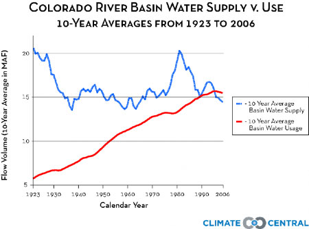
Figure 2. Figure reproduced from Bureau of Reclamation’s Lower Colorado Region. [2006] (exact reproduction)
National Geographic [2008] notes that this is in spite of the Colorado River falling to one quarter of its long term average early in the decade, as though it is surprising that the lack of water resources has not deterred people from moving to the area. Certainly, though, it seems that such an increase in the number of people has at least somewhat diminished water resources. Many researchers have turned to climate change as a huge factor in the shortages, as warmer temperatures have led to less snow and therefore less snow melt [Kunzig, 2008]. Lake Mead depends almost exclusively on this melt [Interior, 2012], as do the tributaries of Mono Lake [Hamburger, 2012]. Temperatures in the West are up 4 degrees Fahrenheit over the last 30 years, and the already small snowpack has been melting earlier than usual, drying up both the land and the water reserves [Interior, 2012].
Groundwater depletion is another serious concern, especially for Arizona and California [Ackerman and Stanton, 2011]. Figure 3 shows projected groundwater extraction for the next 100 years, prorated to current rates (Baseline), with moderate climate change (B1), and with severe climate change (A2) [Ackerman and Stanton, 2011]. Arizona and California remain the only states with an overdraft on groundwater extraction before any sort of projected climate change.

Figure 3. Figure reproduced from Stanton. [2011] (exact reproduction)
The Sierra Nevada region is known for having a shallow aquifer, as is common in desert areas with nearby limestone mountains [Ackerman and Stanton, 2011]. California receives 33% of its water from groundwater; Arizona receives 49% and is now under a state mandate to stop depleting the aquifer (the layer of permeable rock from which water can be extracted) [Kunzig, 2008]. Satellite data has been used to estimate the amount of groundwater extracted from the San Joaquin River Basin, as California has a policy of not requiring permits for wells or any sort of accounting for water taken [Ackerman and Stanton, 2011]. It was found that nearly 16.5 million acre–feet of groundwater were extracted from San Joaquin, an amount which is not considered sustainable [Ackerman and Stanton, 2011]. California’s policies tend to make the measurement of groundwater drawdown quite difficult, contributing to the excessive takings.
Despite all of the factors which lead to shortages, or perhaps because of them, most of the states in the Colorado Basin have implemented conservation policies. San Diego, Las Vegas, Tucson, Albuquerque, and El Paso regularly impose water use restrictions and it is common in most states to have restrictions on outdoor water use [Kunzig, 2008]. For example, one can only water his lawn twice a week and there is no spraying down of sidewalks or driveways in Los Angeles during droughts [L.A Times, 2012] Las Vegas has some of the strictest policies, as they have prohibited new front yards and are limiting the size of backyards [Kunzig, 2008]. They also provide incentives to cut back on water use; as of 2008 the city offered residents 2 dollars per square foot to remove their lawns and replace them with desert plants [Kunzig, 2008]. The efforts seem to be working so far. Las Vegas cut water use by 20% between 2002 and 2006 despite a rise in population, as has Albuquerque [Kunzig, 2008]. Significantly tighter restrictions will be necessary, however, for the Southwest to make up for its shortages.
Part III: Possible Applications of Audubon Precedent
With the broad definition of public trust including recreational and environmental purposes and even non–navigable waterways which lead to navigable ones, it would seem that virtually any body of water could be considered public trust and therefore not able to be used for consumption. That has not been the case so far; environmental groups have not begun to throw lawsuits at any corporation which tries to provide water to residents of the Southwest. The San Joaquin River, however, seems to be the most likely candidate for future litigation. The precedent of public trust having equal or more weight that water appropriation has already been set in California, and the San Joaquin River would fall under the scope of that decision. More telling, however, are the environmental concerns that correlate to its diversion. Its watershed supports 40 species of freshwater fish and those are at considerable risk because of rising salinity levels from water diversion [San Joaquin Basin website, 2012]. Salmon specifically are affected by the flow reduction, as their run upstream because significantly more difficult [San Joaquin Basin website, 2012]. The run has dropped from 15,000 in the 1920’s to between 3,000–7,000 in present day, and dams have blocked many of the main spawning areas [San Joaquin Basin website, 2012]. The fact that such disruptions in the ecosystem can be directly tied to water takings would suggest that the San Joaquin River could someday be under similar protections as that of Mono Lake.
Conclusion
California’s "Water Wars" have been raging since the beginning of the 20th century and show no signs of slowing any time soon. The story of Mono Lake is that of a legal victory; it can be called a success once water levels are raised and the balance of its ecosystem restored. Within the next century, similarly desperate situations may arise in the San Joaquin and Colorado River Basins as populations boom, temperatures rise, and water becomes an even scarcer commodity. It is easy to blame the large, faceless corporations which harvest or divert natural water sources for a profit, but one must keep in mind that they are supporting human populations. The question of valuing comfortable lifestyles over balanced ecosystems is finally being acknowledged, and it seems the discussion is not likely to end any time soon.
Works Cited
National Audubon Society v. Superior Court, 658 P. 2d 709 – Cal: Supreme Court 1983. Case briefing. website
Hill, Mary. Geology of the Sierra Nevada. University of California Press. 2006.
Sax, Joseph, et al. Legal Control of Water Resources: Cases and Materials. American Casebook Series. 2000.
Sax, Joseph. The Public Trust Doctrine in Natural Resource Law: Effective Judicial Intervention. Michigan Law Review.
Kunzig, Robert. The Drying of the West. National Geographic. February 2008. website.
U.S. Fish and Wildlife Services. San Joaquin River National Wildlife Refuge: Final Comprehensive Conservation Plan. 29 September 2006. PDF
Villaraigosa, Antonio. Securing L.A.’s Water Supply. City of Los Angeles Department of Water and Power. May 2008. PDF
Lower Colorado Region Bureau of Reclamation. Colorado River Water Supply v. Use. 2006. website
Ackerman, Frank and Elizabeth Stanton. The Last Drop: Climate Change and the Southwest Water Crisis. Stockholm Environment Institute. February 2011. PDF.
L.A. Times. Los Angeles Water Use is Creeping Up. Online edition. 8 May 2012. website.
Glen Canyon Institute. Who We Are. 2012. website.
San Joaquin Basin. Background. 2012. website.
United States Geological Survey. Study Unit Description. U.S. Department of the Interior. 14 June 2011. website.
Hamburger, Michael. Volcanoes of the Eastern Sierra Nevadas. Lecture. 17-31 May 2012.
Rupp, John. Volcanoes of the Eastern Sierra Nevadas. Lecture. 17–31 May 2012.
Montgomery, David R. (1993–06). Compressional uplift in the central California Coast Ranges. Department of Geological Sciences and Quatenary Research Center. University of Washington, Seattle. 10 June 2012.
Lower Colorado Region Bureau of Reclamation. Lake Mead. U.S. Department of the Interior. December 2008. website.
Lower Colorado Region Bureau of Reclamation. Lake Powell. U.S. Department of the Interior. 10 May 2012. website.