Geology and Natural Heritage of the Long Valley Caldera
Domes of the Mono-Inyo Craters Range
Steven Barajas
Abstract
The Mono–Inyo Craters are a chain of volcanic domes, lava flows, and craters in the western United States. More specifically it is located in the Mono Basin in eastern California about 30 kilometers south of Mono Lake; the Mono Basin is part of the Great Basin. This range is predominantly oriented north to south. The southern edge of Mammoth Mountain is the southern border of Mono-Inyo Crater Range while the northwest shoreline of Mono Lake is the northern most edge. This region stretches a length of about 40 kilometers. The Inyo Craters itself, however, only extends for about 12 kilometers. The Inyo Craters are relatively young, estimated to be anywhere from 500 to 5,000 years old. Sorey calls this range "one of several geologically youthful volcanic systems." The origins of this region can be traced back to volcanic activity. For this reason, volcanic rocks such as rhyolite, pumice, and obsidian are primarily found at the site of the domes. According to the Global Volcanism Program, evidence shows that the last eruption at this location was roughly 1790 years ago, and the last activity was only 230 years ago.
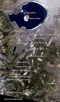
Figure 1: NASA. Mono Lake, Mono-Inyo Craters, Mammoth Mountain. 29 Sept. 2000.
Introduction
The Inyo Craters is a chain that contains the Wilson Butte, Obsidian Dome, Glass Creek Dome, North Deadman Creek Dome, and South Deadman Creek Dome. Each dome has its own chemical make–up. Because of this, their physical properties vary. The ages of these domes can be found using radio–isotopic or radiocarbon dating methods; the dates are identified as being part of the late Tertiary to Quaternary (Bailey and Swenson). According to Roy Bailey, the Inyo Craters chain is a "discontinuous line of volcanic domes and craters extending…into the west moat of the Long Valley caldera." For the most part, the way in which the domes are thought to have been created is very widely accepted throughout the scientific field. There is a connection among these similar volcanic domes around the world. There is not an absence of volcanic activity in the vicinity of these domes. The U.S. Geological Survey states that this entire area is typically under constant unrest with anything from minor earthquakes to dangerous eruptions. As a result, the people here must be aware of the behavioral conditions issued for this area.
Background
The Inyo Craters Range contains domes that are very close in age. A couple domes just north of Deadmans Creek Dome are a few thousand years old; the Wilson Butte and other domes at the north end of chain are estimated to be 1,100 years old; Obsidian Dome, Glass Creek Dome, and South Deadman Dome are all only about 550 years old (Fink). The difference in age is only just over a couple thousand years which, from a geological standpoint, is not much of a difference. This is the reason Fink describes these structures as being formed "almost simultaneously."
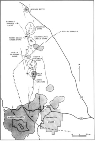
Figure 2: USGS. Aerial Diagram: Mono–Inyo Craters and Mammoth Mountain
This range is located in an area with high concentrations of tectonic activity; much of this activity is also associated with the activity found at the nearby Long Valley caldera. There is a reason as to why this specific landform is housed in this specific geographic area rather than randomly being located anywhere on the surface of the earth. Compared to other geo–structures, the Inyo Craters Range is fairly young. Volcanism in this region began about 3.2 million years ago when basaltic and andesitic eruptions took place (Bailey). Hill and Bailey have noted that over the last 3,000 years or so, eruptions have taken place at roughly 500 year intervals. The most recent eruptions happened about 500–600 years ago (Sieh). With these two pieces of information, one can use the past as a key to the future. One can infer that the next eruption will most likely occur in the very near future because it is "due" for its next eruption according to recent history.
Observations
From afar, the domes look to have a very grey toned color to them; colors range from a slight off–white to a relatively deep black. The fact that there is very little vegetation on the surface of these domes also contributes to its color for if there was vegetation, the domes would appear to be much greener. However, the base of the domes and the space between each individual dome is green and alive with vegetation. Prominent vegetation that is native to this area includes Jeffrey pine trees and a shrubby bush known as sagebrush (Dale). Animal wildlife consists of marmots, raccoons, mule deer, coyotes, and even black bears and mountain lions (Dale). Because this desert land only receives an average of 14 inches of water annually, it is difficult for it to support a largely populated ecosystem (Dale).
The largest dome in size, Obsidian Dome, reaches roughly one mile in diameter and up to 300 feet from the base to the highest tip. The other main domes of the Inyo Crater range are only slightly smaller; however, there are unnamed, less significant domes that are much smaller. Because these domes have remained reasonably unchanged physically since they were created, geologists can directly observe the structures that have not been through much weathering. The unaltered geometry can help answer the questions as to how these structures formed and why.
The rocks on each dome have physical features that are partially dictated by the rate of cooling of the lava. Porpyritic textures are found in rocks that cooled slowly because crystals had time to grow within the rock. Glassy textures are found in rocks that cooled quickly; minimal amounts of crystals were able to grow in the time allotted. Also, other rapidly cooling rocks are present with pumiceous textures. These specific rocks are very porous and buoyant (not dense). Other properties of the rocks include their angularity. Some surfaces of rocks are very well rounded and smooth. The surfaces of other rocks are still smooth yet have very sharp edges and corners. Unlike other boulders that have been transported for an extensive amount of time over large distances, the rocks at these domes have not been in existence for nearly as long and have remained almost completely stationary.
Interpretations
Because these domes are very young and have a great deal of information to offer, there is little debate as to how these domes formed. Observations at the micro and macro scale are taken into consideration in order to grasp a full understanding. Looking at similar landforms and using the present as a key to the past can assist in accumulating an accurate conclusion.
According to Fink, there are at least six major rhyolitic vents that allow magma to escape the subsurface. These vents are all located at roughly the northeast edge of their respectable structure. Fink explains this phenomenon by stating that it is assumed that the Inyo dike is divided into separate segments, slightly morphed and rotated, and obliquely rose during the rising process. Swenson agrees by writing that the orientation and location of these structures, in some cases, directly reflect the orientation and location of the underlying dike. The moment magma reaches the surface, it is considered lava. The lava is typically an extremely viscous substance that, at times, acts almost as a solid. Nevertheless, the substance is still a flowing liquid. It is known that the youngest products erupted from a silica rich dike. The creation of these new dikes is influenced by older dikes under older domes. The alignment of the ground cracks, abundance of explosion craters, surface structures on the domes, and the same alignment and features shared by neighboring structures all suggest that the original dike spread to either side. The original dike and newly created dikes rose as they moved northward from their original location somewhere below Mammoth Mountain. These particular dikes move towards to surface of the Earth through volcanic rocks that are saturated with water (Fink). There is evidence to support that the vents themselves may have migrated northward. These vents changed from violently explosive eruptions to a more calm and "oozy" expulsion of lava (Swenson).
Bailey believes that the Inyo Domes are fluidal mixtures of different kinds of rhyolite lava that erupted on a north trending fissure. With this, Bailey made the interpretation that magma was in fact a mixture partially made up of the magma from the Long Valley chamber and partially made up of the magma from the Mono Craters chamber. This chamber that houses the mixed magmas, however, is not an ordinary chamber. This significantly smaller chamber is a less structured, dike–like chamber that is about 10 to 20 kilometers below the surface (Hill et al). This chamber may have been created by an up flow of magma that came into contact with groundwater at shallow depths. This contact superheated the material causing the water to burst explosively into steam that escapes into the atmosphere through fumaroles.
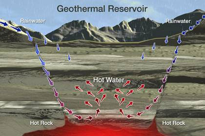
Figure 3: Geothermal Energy Association. Geothermal Reservoir. 2003. Web. website.
The domes of the Inyo Crater range cross right into the Long Valley caldera boundary, a distinctly different landform. The fault that intersects at this location does not seem to have major affects on the site of recent eruptions (Fink). The geometry and alignment of the domes are studied in order to understand what exactly is occurring below the ground surface. The geometry of the domes has given insight to geologists that the dike underneath the younger products has been divided into a minimum of three separate segments (Bailey). In a published article, Ewert describes the lengthy and sometimes costly process of exploratory drilling which helps find answers to these ambiguities.
Activity
The status of the volcanic activity at the Inyo Craters range indicates that this range is very active. This region has often been described as "restless." Such "restless" activity includes entry of intrusive rocks, earthquakes, ground deformation, changes in steam discharge, and increased up flow of magmatic gas. Ground deformation, for example, is evidence of activity not only because it is visible and can be measured, but also because the ground deforms in this case because of sudden changes in pressure that are caused by the motion of the faults. In addition to these faults and cracks, the range has experienced increased seismic activity over the past decade or so, however, this may only be a temporary increase (Swenson). At depths of 10 to 25 kilometers underground, movement of basaltic magma is enough to start earthquakes; some are too insignificant to even feel while others are enough to drastically shift the ground and crack the crust of the earth. Gas emissions such as carbon dioxide are also a sign that indicates that magmatic processes of this area are still underway.
Affects on Humans
Although it is only experiencing its natural cycles, the range’s activity can be potentially dangerous to humans. In the closing statement in one of Fink’s abstracts, Fink writes that the "monitoring of changing patterns of ground cracks and faults may assist in predicting the sites and timing of future eruptions." Swenson feels that it is possible to detect eruptions in certain areas up to months before by studying the deformation of the surface and the manner in which magma has intruded, if any at all. This is the reason preservation can be useful to infer vent orientation and subsurface geometry, but maybe more importantly, the timing of predicted eruptions. However, Fink continues in his article by stating that estimating a warning based on the creation of new cracks may be fairly complicated. His reasoning: not enough scientific observations have been documented in the past to use in the present.
When the next eruption does indeed occur, it will most likely not produce an eruption to the scale of its full potential, that is, it has the capability to produce a fairly enormous eruption, yet it will only produce an eruption a fraction of that size (Hill). The most recent eruption, for example, was one that ejected roughly 2 kilometers cubed of lava and debris from its vents. This is approximately .2 kilometers cubed of material per vent. Thick ash fall and pyroclastic flows were measured as far as six to nine kilometers from the vents (Sieh). This eruption was relatively small though compared to what its potential size was. The strength of the rocks above the vents highly influences the volume of magma that can be added to a chamber before it erupts and how large of an explosion it will be (Hill and Bailey). In theory, if the rock is very weak, then high pressure will not build up because the pressure will quickly break through the weak rock and escape and eruptions will fairly small. On the other hand, very durable and strong rock will cause high pressure to build up and cause much larger eruptions. In their article, Hill and Bailey state that enough warning is issued to properly advise the people of the area. They write that activity is usually preceded by accelerated rates of ground deformation and seismic activity days or even months before an eruption. However, such a large margin of error can cause uncertainty in predictions.
Humans take advantage of the energy that radiates from the Earth. As shown in the figure below, manmade plants can capture, harness, and transform naturally occurring hydro and thermal energy into a useable form of power. The undesired material is separated from the source. The useful and now purified substance is fed threw a turbine. It is then transported and put threw a generator to provide power in the form of heat, electricity, and cooling. High pressure is added throughout this system where it is necessary to keep water at a certain state with a certain temperature. The Inyo Craters range or other similar sites have suitable conditions for such processes. Wind and solar energy are also considered renewable source of energy as opposed to oil, timber, and coal, for example. Most of these methods, however, produce hazardous byproducts that must be disposed of properly for safety reasons. Although the Inyo Crater range is potentially hazardous to the general public whether it is natural or not, Sorey thinks the benefit outweighs the cost. It also provides a vast amount of recreational opportunities and incredible scenery (Sorey).
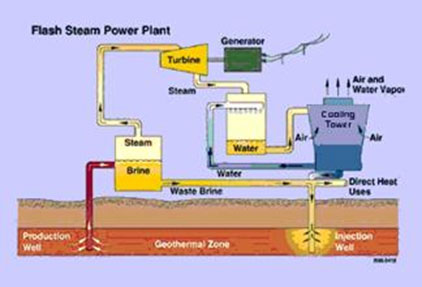
Figure 4: Geothermal Energy Association. Flash Power Plant Diagram. 2003. Web. website.
Conclusion
The Mono–Inyo Craters range is a highly active area that has potential for another eruption in the near future. The regions activity, however, can be put to use by establishing and utilizing energy plants. The risks are there, but for now the power that is being generated is an enormous benefit. The domes of this area are associated with pyroclastic material and are believed to be created almost simultaneously geologically speaking. Knowing the fundamentals, such as rocks types and basic biology, can largely help associate and differentiate this landform from others. Taking into consideration and understanding the macro scale and micro scale of the region is vital to accumulate an accurate conclusion. Because these domes are so young, studying the "fresh" surface, core, and underground material can be extremely useful in putting together an accurate story of when, how, and why these domes and the surround features were formed. With this information, geologists surveying this land can also generate a history of its past and use that information to predict current and future events.
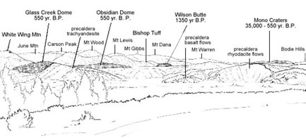
Figure 5: USGS. Panorama from Lookout Mountain. 2004. Web. website.
Works Cited
Bailey, Roy and David Hill. Active Tectonic and Magmatic Processes Beneath Long Valley Caldera, Eastern California: An Overview. Journal of Geophysical Research. Vol 90, pages 11,111–11,120. 10 November 1985.
Bursik, Marcus and Kerry Sieh. Range Front Faulting and Volcanism in the Mono Basin, Eastern California. Journal of Geophysical Research. Vol 94, pages 15,587–15,609. 10 November 1989.
Dale, John. Ecological Sections, Sierra Nevada. California Forest Health: 1994 and 1995. San Francisco, USDA Forest Service. 13 December 2009.
Ewer, John and Christopher Harpel. Bibliography of Literature Pertaining to Long Valley Caldera and Associated Volcanic Fields. USGS. Menlo Park, CA. 2005.
Fink, Jonathan. Geometry of Silicic Dikes Beneath the Inyo Domes, California. Journal of Geophysical Research. Vol 90, pages 11,127–11,133. 10 November 1985.
Geothermal Energy Association. Flash Power Plant Diagram. 2003. Web. website.
Hill et al. Response Plan for Volcano Hazards in the Long Valley Caldera and Mono Craters Region California. USGS. Menlo Park, CA. 2002.
Inyo Craters Global Volcanism Program. Smithsonian Institution. 20 December 2008.
Mono Lake Volcanic Field. Global Volcanism Program. Smithsonian Institution. 20 December 2008.
NASA. Mono Lake, Mono-Inyo Craters, Mammoth Mountain. 29 Sept. 2000.
Sorey et al. Effects of Geothermal Development on Deformation in the Long Valley Caldera, Eastern California, 1985-1994. Journal of Geophysical Research. Vol 100, pages 12,475–12,486. 10 July 1995.
Sorey et al. Summary of Recent Research in Long Valley Caldera, California Journal of Volcanology and Geothermal Research. Pages 165–173. 2003.
Swenson, Mike. Journal of Geology and Geophysics. Pages 220-231. 2005.