Geology and Natural Heritage of the Long Valley Caldera
The Owens River Valley: A Dry Lake and a Water Controversy
Andrea Balzano
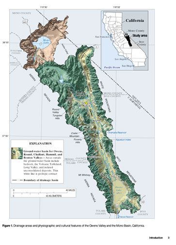
Figure 1: The Owens River runs southward between the Sierra Nevada to the west and the White and Inyo Mountains to the east. Water flows from these mountain ranges into the river via creeks and tributaries. Owens Lake (labeled here) is now dry, as a result of the Los Angeles water diversions. Figure reproduced from Danskin (1998); caption shown in figure his words.
Abstract
The Owens River Valley is a prime example of the water issues California faces and the ongoing battle between the Los Angeles Department of Water and Power and the residents of the Owens River Valley. Part of the Basin and Range Province in the Western United States, the valley is nestled between the Sierra Nevada to the west and White–Inyo Mountains to the east. The valley is made up of creeks and tributaries that run off from the Eastern Sierra Nevada into the Owens River, flowing into the now dry Owens Lake. In 1913, the LADWP finished the aqueduct and began water diversions, which eventually dried out the lake. Then, in 1970 groundwater pumping caused more severe damage to the Valley. Recently, two legal agreements, the Inyo–Los Angeles Long Term Water Agreement and the Memorandum of Understanding, have been made between the multiple actors on both the LA side and the Owens Valley Committee side. The Lower Owens River Project (LORP) is a current project in which LA has to restore damage done to the area between 1970 and 1990.
Introduction
Because of geological setting of the Owens Valley, it serves as the main source of water for Los Angeles. Through the Owens River–Los Angeles Water Aqueduct, the surface water is diverted 200 miles south of the Valley to LA. Part of the Basin and Range Province, the Owens Valley is the western most basin with the Sierra Nevada to the west and the Inyo–White Mountains to the east. The runoff from these mountain ranges consists of multiple tributaries and creeks, running into the now dry Owens Lake (as shown in Figure 1), which is the remnant of glacial activity in the last glacial period roughly 10,000 years ago (USGS).
Danskin (1998) reported that the LA Department of Water and Power finished building the 233–mile long aqueduct system in 1913, supplying an average of 330,000 acre–ft/yd of surface water to the city. Diversions from the Mono Lake Basin, which is just north of the Owens Valley (and shaded brown in Figure 1), are also included in the aqueduct system. The LADWP added groundwater pumping between 1970 and 1990 to the aqueduct system, as reported by the Owens Valley Committee. This led to the now almost century long battle between the LADWP and local residents.
Observations
Geological Formation and Hydrological Setting of the Owens Valley
Motion between the Pacific and North American plates creates a shear zone in which the Owens Valley is located. The Valley is a graben, with normal oblique slip faults on either side, as well as the active Owens Valley strike–slip fault. According to the USGS (2012), the graben formed between 12 and six million years ago, and faulting likely moved from south to north as time went on. The Coso volcanic field lies to the south and the Long Valley Caldera lies to the north of the Valley, which are both seismically active and have geothermal power plants (USGS 2012). The USGS reported that within the last 300-600 years, volcanic activity along the Inyo–Mono Craters chain and the Mono Lake Islands occurred. Examining the hydrological setting of the Owens Valley, Danskin (1998) categorized the area into three parts: "(1) an unsaturated zone affected by precipitation and evapotranspiration; (2) a surface-water system composed of the Owens River, the Los Angeles Aqueduct, tributary streams, canals, ditches, and ponds, and (3) a saturated ground–water system contained in the valley fill." These three parts play a role in where the diverted water and water used locally in the valley comes from.
Building the Aqueduct
Before LA began the construction of the aqueduct, the Owens Valley was used for agriculture, producing and sustaining both livestock and crops. According to Vorster (1992), agriculture began in the area in the 1860s. Near the turn of the century, Vorster (1992) reported the first man–made canals were constructed in the valley, as farmers needed water in more areas. These, however, were minute in comparison with what LA later constructed. The surrounding mining towns such as Bodie, Aurora, and Cerro Gordo, provided the demand for the agriculture business. In terms of agriculture, geology played an importance roll; Vorster (1992) reported that fruit bearing trees were commonly planted on alluvial fans where frost was at a minimum.
Los Angeles first became interested in the area for its water resources in 1903, and officially began construction on the aqueduct in 1907, finishing in 1913 (Vorster, 1992). The diversions were near Independence, which is south of the then major agricultural area of Bishop and Big Pine. Most of the land LA owned was also south of this area. For these reasons, in the early years the farmers and LA were peaceful. In 1923, LA began buying more water rights and land to ensure a supply of water for the aqueduct (Vorster 1992).
Libecap (2005) reported that by 1935, LA had purchased 95 percent of farmland and 88 percent of town land in the Owens Valley. Then in 1970, the LADWP expanded the aqueduct system and began to pump groundwater to meet their demand. The springs, wetlands, and alkali meadows that had so far survived the LADWP water diversions were, according to the Owens Valley Committee website, immediately effected by the pumping of groundwater. Figure 2 shows the main points along the aqueduct.
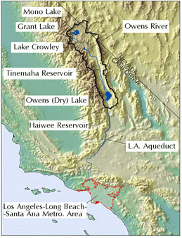
Figure 2: The LADWP’s aqueduct system’s most northern point is in Mono Basin, trailing through the Owens River Valley past Grant Lake, Lake Crowley, the Tinemaha Reservoir, the dry Owens Lake, and the Haiwee Reservoir. The aqueduct takes water to LA, 200 miles south of the Valley. Figure reproduced from hydrologyfutures.com.
Groundwater Discussion
To fully comprehend where the water comes from that LA has been and continues to divert from the Owens River Valley, it is necessary to understand the idea of groundwater and the water table. E.C. Pielou (1998) is quoted on the Owens Valley Committee website describing groundwater as, "water that saturates the ground, filling all the available spaces." Groundwater also encompasses water that is in the saturated zone, which is part of the water table. The water table is generally parallel to the ground surface. However, in the Owens Valley, an unsaturated zone often lies between the groundwater and surface, scattered with air pockets or nearly dry areas. The water that does exist in this area is vadose water (OCV). According to the OCV, three major factors effect types, sizes, and number of plans growing on the ground: the amount a vadose water, the permeability of the soil, and the depth of the water table. The water table is the "distance between the ground’s surface and the upper boundary of the saturated zone" (OCV website). Figure 3 helps visualize these terms.
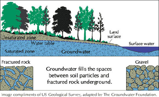
Figure 3: In the Owens Valley, there is an unsaturated zone between the ground and the water table. Beneath the water table is groundwater, which is water between rocks and soil. The water table is "the distance between the ground’s surface and the upper boundary of the saturated zone" (OVC website). Figure reproduced from the USGS; caption in photo is not my words.
Meteoric groundwater, "groundwater that circulates as part of the water cycle" (Pielou 1998) is of most concern in the Owens Valley issue. Meteoric groundwater is made and rejuvenated by precipitation and surface water that seeps down through the unsaturated zone, eventually reaching down to the water table. This meteoric water is important because the Owens Valley does not receive very much precipitation, but instead relies on snowmelt and runoff from the Easter Sierra Nevada and Western White–Inyo Mountain ranges (OCV website). The snowmelt and runoff flow through alluvial fans and connect to creeks and tributaries, watering the Owens River Valley.
Groundwater in Connection with Aqueduct
Groundwater regains its proper levels depending on the permeability of the soil, how much water falls in the system, how moist the soil is, and how quickly water falls. If the soil is dry, and a heavy rain comes, it will rush away in streams as opposed to being absorbed back into the ground (OCV website). The LADWP’s diversion of water from Owens Valley changed the way water was recharged into the system because they are both diverting surface water and pumping groundwater. Combined, this changes the vegetation and number of springs in the Valley (Danskin 1998). Although there was a reduction in the amount of groundwater that was pumped, the vegetation and springs did not recover completely (OVC website).
Agreements – Helpful or Ignored?
After the LADWP began pumping groundwater in 1970, and the effects were clearly evident to residents in the area, Inyo County filed suit under the California Environmental Quality Act. Nineteen years of litigation ensued, ending with the signing of the Inyo–LA Long Term Water Agreement (LTWA). This requires that pumping be properly managed to keep a water supply that is sufficient for both the Valley ecosystems and the city of Los Angeles water demand. According to the OVC’s website, the LTWA has not been as effective as hoped.
Then in 1997 the Memorandum of Understanding between several actors including the City of Los Angeles, Inyo County, and the Owens Valley Committee, was signed. Its intent was, according to the OVC website, to increase monitoring of vegetation that is dependent on groundwater in the Valley, revegetation in areas severely damaged by the LADWP, recovery of areas damaged by drought, rewatering of a 60–mile stretch of the Owens Rover originally diverted in 1913, and monitoring of natural resources on LADWP land. Again, the Owens Valley Committee finds the LADWP not sufficient, claiming that they are still pumping harmful amounts of groundwater making revegetation, rewatering, and overall recovery difficult.
Current Project: LORP
The Lower Owens River Project was implemented as a means for the LADWP to make up for the damage they did pumping groundwater from 1970-1990. According to the OVC website, "The LORP promises to restore 62 miles of the lower Owens River; to maintain, enhance and create hundreds of acres of new habitat for waterfowl and other wildlife; and to greatly improve the warm water fishery," which could help both the environment and local economies. In 2006, LA began releasing 40 cubic feet per second into the Lower Owens River (OVC). In 2008, LA began "seasonal habitat flow" which is a period of increased water flows that simulate natural flooding with the hope that cottonwood and willow seeds will be carried downstream to eventually create riparian streams (OVC). Actors in the Memorandum of Understanding are currently working to improve plans for monitoring the LORP so that the Memorandum is fulfilled and the restoration process is fully meant.
Interpretations
A Rich Water Environment
Both the geological and hydrological setting of the Owens River Valley not only make it an appealing avenue for the Los Angeles Department of Water and Power to build an aqueduct, but also make it a good location for agriculture and a rich place for vegetation and wildlife to flourish. Because the Valley is situated between the Sierra Nevada to the west and the White–Inyo Mountains to the east, the snowmelt and runoff are plentiful. It is the first basin from the west, so as clouds full of precipitation move east over the Sierras they drop their first and heaviest load there. The snow dropped there provides for the spring runoff that flows into the valley. Moving eastward across the Basin and Range Province, precipitation decreases, which is why the Owens Valley, as the first valley from the west, is the most precipitated.
Looking at the three parts Danskin (1998) divided the valley into and fitting them into the information provided by the Owens Valley Committee, it suggests that all three of those categories of water of have been affected by the aqueduct system. The unsaturated zone has less snowmelt and runoff periodically coming through it because upstream water is being diverted. The multiple dams and reservoirs scattered throughout the Valley, as well as the fact that Owens Lake is now dry, show how surface water is being diverted by the LADWP. Finally, the saturated groundwater system is also being pumped to the aqueduct, further depleting the area of water resources.
Throughout the twentieth century, LA built the aqueduct, damming streams and creeks, creating reservoirs, and pumping groundwater. This resulted in a series of lawsuits and agreements between the City of Los Angeles and several players on the Owens Valley side such as the Owens Valley Committee. Groundwater pumping became especially destructive to plant and animal life in the Valley between 1970 and 1990, resulting in the Memorandum of Understanding and the Lower Owens River Project. Unfortunately, the OVC has found the City of Los Angeles’s effort to restore life and vegetation in the lower parts of the valley insufficient. To fix this problem, the Committee urges interested individuals to get involved and offer alternative plans or ideas to monitor the LADWP’s involvement in and upkeep of the Valley.
Groundwater has proven to be a hot topic. LA not only diverted surface water from streams, creeks and tributaries in the Valley for years, but also in the 1970s they began pumping groundwater, which is not easy to replenish. Coupled with the worldwide increase in temperature, pumping groundwater is making the depleting groundwater resources dissolve quicker, which in turn affects the vegetation and wildlife in the area. Various plant species, birds, and land mammals live in the area, living off of groundwater supplies. The combination of the LADWP pumping groundwater and the natural decreasing amount of snowmelt and runoff has had dyer effects on the vegetation and wildlife, drying out the valley to an extremely harmful level.
The Lower Owens River Project has set high hopes for the LADWP to help restore life and water supplies in the Valley, but they have unfortunately not been up to par with what the Owens Valley Committee had in mind. This current program aims to restore the Valley to the state it was in before the LADWP began pumping groundwater in 1970. However, because the LADWP is not pulling their end of the bargain, citizens will need to step in, sharing ideas for improvement, monitoring, and management of the restoration process.
Conclusion
The geological formation and the hydrological setting of the Owens River Valley have left it a place that once was rich in water, making it an ideal place for the City of Los Angeles to divert water flows to meet their water demands. A graben between the Sierra Nevada to the west and the White–Inyo Mountain ranges to the east, snowmelt and runoff were plentiful in the valley. As the gold rush brought miners to the mountains, farmers also came to the Valley. Early water diversions were minimal, but in 1903, LA began buying land and water rights and building the aqueduct. It now stretches the entire length of the Valley from the northern most point in the Mono Basin, to the southern most point, in the now dry Owens Lake. Pumping groundwater from 1970 to 1990 caused severe harm to the vegetation and wildlife in the Valley, resulting in a series of lawsuits and agreements between the City of LA and various actors working for the Valley. This led to the Lower Owens River Project, which is currently being reworked by local citizens to best meet the restoration needs of the Valley and monitor the LADWP’s involvement with the project. Overall, the Los Angeles Department of Water and Power’s 233 mile long aqueduct system that stretches the entire Owens River Valley exemplifies how big city needs can trump nature’s needs, depleting natural water sources, vegetation, and wildlife.
Works Cited
Danskin, R. Wesley. USGS, CA–Owens Valley Hydrogeology Overview. USGS California Water Science Center. N. p., n.d, Web 6 June 2012. website.
Geologic framework of the Norther Great Basin. Geology and Geophysics. N. p., n. d. Web. 6 June 2012. website.
Hydrology Futures entry. Hydrology Futures entry. N. p., n. d. Web. 6 June 2012. website.
Libecap, Gary D., Chinatown: Owens Valley and Western Water Reallocation – Getting the Record Straight and What it Means for Water Markets. Texas Law Review, Vol. 83, No. 7, pp. 2055-2089, June 2005. Available at SSRN: website
Owens Valley Committee. Owens Valley Committee. N. p., n. d. Web. 6 June 2012. website.
Vorster, Peter. The Development and Decline of Agriculture in the Owens Valley. History of Water: Eastern Sierra Nevada, Owens Valley, White–Inyo Mountains(n.d.): 268–84. University of California. Web. 6 June 2012. PDF.