Geology and Natural Heritage of the Long Valley Caldera
The Water Mess in the American West
Ryan Wells
Abstract
Almost all of the Western US receives less than half a meter of precipitation each year, yet water is still greatly wasted. When this waste is added to the scarce supply that the West has to offer, a crisis begins to build. Instead of focusing water rights on the people, the vast majority of it is siphoned to agriculture, essentially growing crops in the desert. Add this water usage to a growing population that has polluted and used up many of its resources, and it does not seem wise to water the desert any longer. There are solutions there: find more water and use less of it. The most viable options include desalinating sea water while adjusting pricing mechanisms to better fit the market, employing more efficient farming technology, conserving, and changing outdated water right policies.
Introduction
An old Western saying goes something like this: “Whiskey is for drinkin’ and water is for fightin’.” This adage is especially poignant in the American West, where water shortages have led to innumerous conflicts between urbanites and farmers, environmentalists and industrialists. It is appropriate to mention that the last time that two states took up arms against one another was over the sore subject of water. In 1944 Arizona Governor Benjamin Moeur dispatched one hundred men, armed with machine guns, to the Parker Dam construction site, arguing that California had been illegally sequestering water without license from Arizona. The Supreme Court Ruled in favor of Moeur’s claim, but Congress overruled and passed a bill that legalized the expropriation of water (De Villiers 16). But that did not end the bickering between any of the Western states over the hot topic of water.
The vast majority of the American West is a semiarid region (25-50 cm of precipitation per year), hardly fit for homesteading, let alone development. Yet it is home to millions of people, including over 37 million Californians alone. For a region to be considered a desert, the total amount of precipitation for the area must be under 25 cm per year (Ferguson). In fact, two of the largest cities in the West, Phoenix and Las Vegas, are situated in the middle of deserts, with annual precipitation rates of 20 cm and 10 cm, respectively (Simon 24). So where does all of the municipal water come from? One might guess that these verdant oases in the middle of parched earth were strategically built on or next to large, sustainable water reserves. But this is not so. Unfortunately the quest for development and money trumps logic in this case; practically every Western US city draws its water from an unsustainable source, oftentimes hundreds of kilometers away. Without water, these artificial oases that hold millions of people will become no different than the stinging desert that surrounds them.
As a whole, the United States receives plenty of water, enough that would allow us to continue recklessly wasting it with little consequence. The problem is that the water is unevenly distributed. Major cities, like Chicago and New York, typically receive twice as much precipitation as any particular point in the southwest. But abundant water resources still exist in the West; they are just located away from the major population centers. For example, 70 percent of California’s freshwater falls as rain or snow in the northern third of the state, while 80 percent of the demand lies in the southern two-thirds of the state (Bourne 143). In California alone, over 3000 km of aqueducts have been put in place to funnel all of that northern water to the thirsty South (Bourne 143). These diversions began in the early 1900’s, when it became evident that Los Angeles’ seasonal streams and small aquifers could not sustain an ever increasing population that is still growing by 2.7 percent each year (Simon 17). By 1913, the city had completed the Los Angeles Aqueduct, a 357 km long tube that stole every drop of Owens River water that it could handle.
A century ago, the main source of water for Los Angeles was the Los Angeles River. It was estimated that the river could supply water for about a quarter million people. In 1900, Los Angeles was a growing city with a manageable population of 102,000 residents (Wheeler). Incredibly, four years later, the population had nearly doubled to 200,000 (Wheeler). It became apparent that Los Angeles would soon run out of water if alternative sources were not discovered. This is where William Mulholland and Frederick Eaton, managers of the Los Angeles Department of Water and Power, come into place. Both began scouring Southern California for options, but none could be found. It was not until Eaton remembered a camping trip of his to Owens Lake that a solution was discovered.
At the time, Owens Lake was the third largest lake in California with a surface area of 280 km squared. Realizing this, Eaton began purchasing large tracts of land surrounding the lake from the farmers and ranchers at very low prices, without disclosing his motivations. If Eaton had told any of them what his intentions were, it is unlikely that many would have sold their lands. Once this act was accomplished the “only” barrier between Owens Lake and Los Angeles was 350 km and a major mountain range. Besides the twelve thousand foot peaks of the Sierra Nevada mountain range, the journey was almost entirely downhill. Gravity alone would transport the water hundreds of kilometers to the city and hydroelectric dams would harness some of the energy.
As the lake receded, tempers flared. In 1927, at least a dozen explosive blasts shook the Owens valley, as locals attempted to destroy the aqueduct and prolong their dwindling way of life. But without a source of fresh water (the Owens River), the lake gradually became more and more saline, and soon Owens Lake was too salty for irrigation. With the lifeblood of the land gone, many farmers packed up and left, looking for greener pastures.
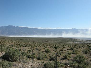
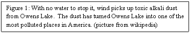
Currently the “lake” is more or less dry; the lack of water has transformed it into a salt flat. With nothing to hold the salt in place, winds easily pick up the loose minerals and sediment (see figure 1). When this happens, great dust storms spread the alkali dust all over and cause respiratory problems among the local population. According to the Environmental Protection Agency, the region surrounding Owens Lake has the worst air pollution in the nation, over six times greater than the second place candidate, the steel mills of Gary, Indiana (Simon 21). To combat the exorbitant amounts of pollution that the lake creates, a fair amount of water (50,000 acre feet) has been recently been redirected to the lake in hopes of reducing the toxic dust storms.
Another source of water, and controversy, in the West is the Colorado River. Perhaps no other river in recent memory has inspired so much emotion. The 1400 mile Colorado River begins in the Rocky Mountains in Colorado and ends its journey in the Gulf of California. The average flow of the river is around 14 million acre-feet per year, but that number can increase to 18 million in good years and decrease to 12 million during droughts (De Villiers 240). It provides water for over 30 million people.
In 1922, 7 states- Arizona, California, Colorado, Nevada, New Mexico, Utah, and Wyoming- signed an agreement to partition the river water. This agreement, signed over 85 years ago, still governs allocations of the river. State by state allotments are as follows: 4.4 million acre-feet for California, 3.9 million for Colorado, 2.8 million for Arizona, 1.725 for Utah, 1.05 million for Wyoming, 844,000 for New Mexico, and 300,000 for Nevada. An additional 1.5 million acre-feet was later granted to Mexico in 1964. Back in 1922, when the amount of water was proportional to the population of the states, the allocations made sense. At that time, Nevada had a population of 70,000 (Simon 27). Now, 90 years later, the population has increased 37-fold, to 2.6 million (source: The fastest growing US cities). Clearly there is not proportionally enough water given to Nevada, but nothing is being done to change it.
Fortunately, the upper four states only use 4 million of their allotted 7.5 million acre-feet. This allows California to take 5.12 million acre-feet, .82 million acre-feet more than its allotted 4.4 million. After receiving extra water for many years now, California is beginning to expect that it will continue to receive this extra water under the “use it or lose it” principles of Western water rights. In the years to come, as the other states begin to use more water, California will be in for a rude awakening.
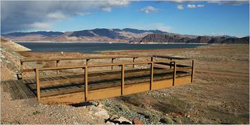
The last factors are the two water reservoirs on the Colorado River: Lake Powell and Lake Mead. At full capacity, the two can hold 24 million acre-feet and 28 million acre-feet, respectively (Gertner). But neither reservoir is anywhere close to capacity (see figure 2). Part of this is due evaporation: the combined evaporation loss from Lake Mead and Lake Powell is about 1.6 million acre-feet every year. That is more water than Wyoming and New Mexico, combined, are allotted each year.
So let’s do the math. The Colorado River has a flow ranging from 12 million acre-feet to 18 million, averaging 14 million. When all of the allotments are added up for each state, you come up with 15 million acre-feet, already over budget for the average year. But when water for Mexico and water lost through evaporation are factored in, the total comes up to a staggering 18.1 million acre-feet. This is over 4 million more acre-feet per year than the average flow of the river! Fortunately the northern four states are not using all of their water yet, making these numbers more or less break even. But this certainly explains why the levels of Lake Powell and Lake Mead are dropping. Marc Reisner describes the over-allocation of the Colorado River best in his book Cadillac Desert: “The Colorado is so used up on its way to the sea that only a bubbling trickle reached its dried-up delta at the head of the Gulf of California, and then only in wet years.” (Reisner)
Once again, the reason that Owens Lake or the Colorado River exist in the first place is due the uneven distribution of water in the West. There are three principal factors that control water placement: global atmospheric circulation, prevailing winds, and topography (Ferguson). Of these three factors, the unique topography of the West best explains the unequal spacing.
Due to the stretching and thinning of the area caused by tectonic forces, much of the American West is covered by an alternating series of high mountain ranges and low basins, known as the Basin and Range province. Generally, these mountain ranges act as cloud formers. When moist Pacific Ocean air reaches the western Sierra Nevada front, it sweeps up the mountain, gaining elevation. The increase in elevation decreases the air pressure and also cools the air. This process continues until the saturation point is reached, when clouds are formed and condensation takes place. Most of this falls in the form of rain or snow on the mountain itself. Eventually the air, much cooler and drier, descends the mountain and absorbs whatever water it can find; ready to start the process over again (Ferguson). Although some of the water eventually flows down the mountains into the valleys, which is the source for the Colorado and Owens Lake, most of the water stays in the mountains themselves, trapped in the snowpack.
So where does all of this water go and who uses it? Most water makes its way to cities and farms for municipal/homeowner purposes, industry and mining, energy production, and of course agriculture.
The established requirement for drinking water per person per day is half of a gallon, yet the average American consumes 50 to 80 gallons each day just for indoor domestic use (Ferguson). Common water-intensive indoor uses include bathing, preparing food, washing dishes and clothes, and flushing the toilet while outdoor practices comprise of watering the lawn or garden and washing the car. If all domestic uses are added up, most Western cities range from 110 gallons per capita (Albuquerque) to 165 (Las Vegas) with cities like Tucson, Phoenix, and Los Angeles somewhere in the middle of these figures (Witchner). These numbers do not take into account the municipal water use though; add this in and the per capita typically increases by another hundred gallons or so (Witchner). Put into comparison with all other uses of water, domestic water use is not that substantial. It accounts for approximately 54 million acre-feet per year, or 23 percent of the entire non-thermoelectric water use (Kenny, Barber, Hutson, Linsey, Lovelace, Maupin 16 and 19).
Each year, industry gobbles up 20.4 million acre-feet of withdrawal in the United States while mining partitions another 4.5 million acre-feet(Kenny, Barber, Hutson, Linsey, Lovelace, Maupin 32 and 35). Industrial water totals are biased towards the east, while mining water is more evenly spread out throughout the country. Water can be employed to mine for solids (coal and iron), liquids (petroleum), or gas (natural gas). Other water intensive processes include milling, quarrying, and re-injecting previously extracted water for secondary recovery.
A substantial amount of water is diverted for hydroelectric energy use, but that water is technically recycled back into the flowing creeks as it exits the dam. Electricity is usually generated by the potential energy of water stored behind a dam, driving the water turbines and a generator. Hydroelectric energy is one of the most prevalent sources of energy in the western United States, where so many rivers have been dammed up to make reservoirs. In fact, nearly all of Idaho’s electricity comes from hydroelectric projects (Kenny, Barber, Hutson, Linsey, Lovelace, Maupin 38). But not everyone agrees that hydroelectric energy is a good practice. It is a highly controversial subject: proponents claim that it is a clean, sustainable energy source while opponents point out the negative ecological and environmental effects.
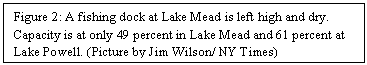
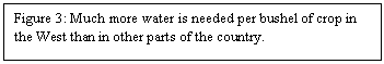
Agriculture is by far the largest user of water in the US, consuming two-thirds of all water (Kenny, Barber, Hutson, Linsey, Lovelace). The relative percentage of agricultural water use is much higher per acre in the western US than it is in the East, where it is not out of the ordinary for states to use 80 or even 90 percent of their water just on agricultural purposes (see figure 3). In California and New Mexico, 85 and 92 percent of all water go towards agriculture, respectively (Reisner: Water: Opposing Viewpoints 40). The reason that these numbers are so dramatically skewed in the West is due to the fact that the precipitation levels are so much lower when compared to other farming regions, like the Midwest. Crops do not require any more water in the desert than they do in a temperate growing region; nature just provides far less water and man has to make up for this difference through irrigation.
The four most water-intensive crops in California are, in order, pasture, alfalfa, cotton, and rice (Reisner: Water: Opposing Viewpoints 40). Studies indicate that one-seventh of all water in California, the same amount of water consumed by the entire population, is sent to irrigate pasture (Reisner: Water: Opposing Viewpoints 40). With such an enormous amount of water aimed towards pastures, one might think that they have an incredible payoff, but that notion could not be further off. California, with an economy larger than most countries, generated a measly $94 million from this water-wasteful crop (Reisner: Water: Opposing Viewpoints 40). This only totals to .2 percent of the economy. It is practically the same story for the other three crops: incredibly water-dependent with hardly any economic payback. Now suppose the entire pasture, cotton, rice, and alfalfa crop was eliminated and nothing else was planted in their place. This would reduce the revenue from the agricultural industry by $1.7 billion, from $14 billion to $12.3 billion (Reisner: Water: Opposing Viewpoints 42). The amount of water that would be saved would be sufficient for the needs of 70 million people (Reisner: Water: Opposing Viewpoints 42).
These statistics were taken over twenty years ago, back in 1986. It is true that the agricultural industry in California has grown between then and now, but it has been outpaced by the overall GDP. Since 1986, the GDP of California has more than tripled from $550 billion to $1.85 trillion. The farm industry has more or less tripled also, from the $14 billion to $36.6 billion (California Department of Food and Agriculture). Assuming that revenue from cotton, alfalfa, pasture, and rice followed the trend and also tripled, to somewhere near $5 billion, it still remains obvious that these four crops do not have any economic significance to California as a whole. So are any of these crops worth the trillions of gallons of water they use each year? Probably not.
Another agricultural folly that involves the entire nation, and not just the West, is the switching over of grains to produce biofuels in the form of ethanol. Ever since President Bush agreed to ramp up ethanol production to 36 billion gallons by 2022, a great amount of farmland that was once used to grow food will need to be converted to produce energy. Praised as a miracle substitute for America’s dependence on foreign oil, ethanol will soon be a national dilemma.
In 2008, 92.7 million tons of US corn was used for fuel ethanol (Brown). That equates to 22.5 percent of the US grain crop used for fuel ethanol (Brown). According to the 2009 Report on Ethanol Market Concentration report, 9 billion gallons of ethanol were produced in the US in the same year (Brown). To reach the goal of 36 billion gallons for 2022, the current ethanol production must be quadrupled. This unrealistically implies that 90 percent of the US grain crop will be required to reach this lofty goal.
This will certainly put an enormous strain on the food supply. For every acre of cropland that is switched from food production to ethanol production, another acre of farmland must be set up to offset the loss in food. This is going to amount to a lot of land converted to farmland which will require even more water. It is obvious that the West cannot handle the added pressures. And it is most likely that more desert land will be converted to farmland, since that is all that is left to develop. Where will this extra water come from? There was already a water crisis building before the concept of mass production of ethanol ever came into the minds of the politicians.
Adding to the complexity of the increasing demand for farmland is the fact that some of the farmland in the West is rapidly deteriorating. Much of this can be blamed on two things: water’s high solvency and the high salinity of the soil in the West.
On its journey from the mountains, water dissolves minerals from the soil and rock that it passes over. When water pools in the fields during irrigation, some of it seeps into the ground. If the soil is not well drained, like in the American West, salts will begin to accumulate in the lower layers of the soil. Eventually the heavy salt concentration will move upwards, towards the surface. In time, and if irrigation continues, the salt will reach the roots of the plants, silently killing the plants and making agriculture indefinitely impossible for decades. But nine-tenths of the salt will remain on the surface, permanently transforming it into dead land. This process has already begun. In California’s Imperial Valley, more land is being decommissioned than commissioned.
It is clear that the growing West is going to need much more water in the years to come, but due to a number of factors, there will be less water when it is needed the most. Some reasons why water reserves are dropping are due to the alarming population growth of the West, water pollution, aquifer depletion, and climate change.
The United States is expecting 100 million more people in the next 25 or 30 years (Gertner). Many of these people will settle in the West, lured by the warm and sunny climate. Population growth is not a new concept in the West. Since 1950, the West’s population has quadrupled (source: Climate Change Impacts on the United States). This trend is still progressing; 7 of the 10 and 21 of the 25 fastest growing cities are out West (source: The fastest growing US cities). More people mean more houses, more businesses, more lawns, more industry, and more agriculture. All of this is going to demand more water and there is simply not enough to go around.
With an increasing human population inevitably comes an increase in pollution. There is no way to avoid it; polluting is what we do the best. We come into pristine environments, mold it to our liking, build cities, and produce waste. Where does all of it end up? Some of it is introduced to the water system.
Water pollution has slowly been improving since the Federal Water Pollution Control Act, better known as the Clean Water Act, was passed in 1972. Discharge from point sources, such as industry and power plants, has been greatly reduced and thousands of miles of river and lake shoreline have been cleaned. While it is clear that the Clean Water Act is helping, it is certainly not doing enough. Cleanup of nonpoint sources from farming, animal feedlots, and golf courses has been insufficient. It is nearly impossible to manage or regulate this type of pollution because it is so spread out. Whenever it rains, water, acting as a solvent, picks up pesticides, waste, fertilizers, etc and enters the watersupply. In the US, about three-quarters of water pollution is derived from nonpoint sources such as soil erosion, air pollution fallout, and agricultural and urban runoff (Ferguson). The cheapest and most effective way to reduce this type of pollution is to avoid introducing it into the environment in the first place. We greatly overuse chemicals, effectively contaminating our water supply. Studies have shown that 90 percent less salt could be used in the winter without significantly compromising road safety (Ferguson). Not only would the environment be better off, but so would the taxpayer’s wallets.
Groundwater has always been considered to be the “gold standard” for water quality, and was foolishly thought to be impervious to pollution until only a few decades ago. The source of drinking water for half of the nation, groundwater is now highly polluted. Even though we now realize that we can mess up groundwater, we still continue to pollute it. The EPA estimates that 4.5 trillion liters of contaminated water seep into the ground in the US every day (Ferguson). Not to mention radioactive material and other types of waste that were buried or injected into wells decades ago. A study taken in 1983 linked birth defects in San Jose to contaminated groundwater (De Villiers 97). Once contaminants enter the groundwater, they are very difficult to remove. Most of it remains in the groundwater until it is pumped out by us. As groundwater becomes more polluted, the cost to remove these pollutants will increase until it is not economically feasible, or even safe to drink the water.
Not only is groundwater being polluted mercilessly, but it is being depleted much faster than it can be replaced. Over 50 billion gallons of groundwater, mostly in the West, are pumped out for agriculture each day in the United States (source: Groundwater Depletion). The effects of this are being felt all over the country. Thousands of wells have gone dry as the water table slowly inches past them. The USDA reports that in parts of Texas, Oklahoma, and Kansas, the water table has dropped by over 30 m (Brown: Aquifer Depletion). Increased pumping in south central Arizona (the Phoenix and Tucson area) due to population growth has led to water level drops of 90 to 150 m with as much as 3.75 m of ground subsidence associated with the loss in groundwater (source: Groundwater Depletion).
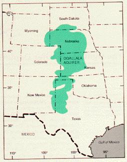
A special case of groundwater is in the form of aquifers. An aquifer is an underground layer of permeable rock or unconsolidated material that holds and transmits enough water to make it a useful source of water. The largest known aquifer in the United States, the Ogallala aquifer, covers an area of 580,000 km squared in 8 states (see figure 4) (De Villiers 154). The Ogallala aquifer is not uniformly thick and it has different recharge levels, varying from a fraction of an inch to a couple of inches per year. Due to this, some places are in better shape than others. Nebraska has a positive recharge rate while Texas has decommissioned one million hectares from the lack of water.
When the aquifer was discovered in the 1930’s it was believed that the crops would never fail again. Although the aquifer itself will probably never run dry (due to the high costs of pumping as depth increases), it is believed by some that as much as 60 percent of the aquifer has already been extracted (De Villiers 44). And it is not looking any more favorable in the years to come since there is a negative imbalance between recharge and discharge.
Aquifers have often been associated with the tragedy of commons.
This theory can be traced back to Aristotle who noted that “what is common to the greatest number has the least care bestowed upon it.” This parable claims that shared resources will inevitably be degraded. In the case of the Ogallala aquifer, each farmer will extract a few extra cubic meters of water, believing that it will have little or no consequence to the overall health of the aquifer. But when these extra cubic meters of water are multiplied by the millions of farmers doing exactly the same as the other, a real problem begins to arise.
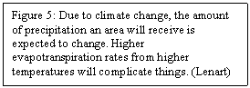
The threat of climate change should also be taken seriously; it will do much more than alter global temperatures. Although it is difficult to predict, annual precipitation patterns are expected to be altered in the years to come (see figure 5). Overall, northern latitudes are predicted to receive more precipitation and southern latitudes, less (Lenart). Meanwhile higher temperatures will likely attribute to higher evapotranspiration rates. While some regions may experience more precipitation, much of that will be lost due to the higher temperatures. Richard Seager, of Columbia University, and colleagues evaluated 19 Global Climate Models (GCM) specifically for the American Southwest. Of these 19 GCMs, 18 suggest an increase in aridity of the southwestern quadrant of the country (Lenart).
Although the West is certainly facing a serious water shortage, there are many plausible solutions out there. The two options are fairly obvious: get more water and use less of it. But the methods to do so are more complex.
Obtaining more water is not an easy feat. We are not making any more of it, but we are not making any less. Many highly speculative methods, like cloud seeding and towing icebergs, are out there. But when it comes down it, there are only two viable options: bring in freshwater from somewhere else or desalinate.
The first option of transporting water from one location to another is already in place in much of the Southwest, and cannot be largely expanded upon. Some would like to see the wild rivers of Canada diverted to regions that need them more, say the Southwest. In their opinion, these rivers are being “wasted” as they flow freely into the ocean. But it is very unlikely that anything like this would ever happen, for the economic and environmental costs would be unimaginable.
A more efficient method of fetching this “wasted” water from up north is being developed. A new technology entitled Medusa is being developed. Designed after a jellyfish, the overall concept is to pull a 500 m by 150 m bag full of fresh water from Alaska to California in the Pacific Ocean (De Villiers). It sounds impossible, even foolhardy to accredit this method, but tests have proven it to be cost effective and efficient. Jim Cran, president of Medusa Corporation, has stated that believes that his company needs a one-third price advantage over desalination, his major competitor. Based upon figures, he claims that this is possible (De Villiers 284). After failing to strike a deal with Los Angeles, Cran has moved to the interior, more specifically Las Vegas. He explains that Las Vegas could purchase water from Medusa and trade it to Los Angeles for a portion of LA’s Colorado River water in return. Although it is revolutionary, Medusa does not have an ocean-full of water at its disposal, like desalination.
Building a desalination plant along the coast is the most straightforward method for supplying water. The basic principle behind the process of desalination to remove all of the salt and other unwanted minerals, leaving behind pure freshwater. Currently there are two principle types of desalination: distillation and reverse osmosis and both have their advantages and disadvantages. For example, distillation produces less waste material than reverse osmosis and does not need to pretreat its water. Conversely, reverse osmosis requires less energy and has higher recovery rates than distillation. But both do have the same disadvantages: desalination is very costly, very energy-intensive and it leaves behind a highly salty brine as a byproduct. Due to these setbacks, desalination plants are most prevalent in the Middle East, where there is no other option. But as the costs continue to decrease, desalination is slowly making its way over to the United States.
Perhaps the most famous of all US desalination plants is located in Tampa, Florida. It supplies water at an incredibly low price for desalination: $650 per acre foot (source: Thirsty?). The reason behind this is the low salinity of Tampa Bay. The bay has a lower salinity than the surrounding ocean. In the world of desalination, as the salinity goes up, so does the price. Based upon this simple explanation, desalination prices in California are estimated to be between $1000 and $4000 per acre-foot (De Villiers 291). In comparison, California spends on average about $300 per acre-foot, (De Villiers 292). Based upon these figures, it is easy to see why desalination has not caught on yet. California is searching for other options, and the least expensive alternatives would cost between $600 and $700 per acre-foot, and much more for most projects (De Villiers 292). And none of these offer the sustainability of desalination.
The most cost effective, environmentally friendly, sustainable, and altogether best way to solve the West’s water problems is to reduce water consumption. This can be accomplished by practicing conservation, implementing pricing mechanisms, developing new technology, and amending existing water right laws.
Conserving water is the best way to reduce water usage in urban areas. The first thing to do would be to replace existing old infrastructure. Oftentimes old, dilapidated infrastructure is one of the biggest wasters of water. On a more personal scale, much can be done to cut back water consumption in the house. Typically 75 percent of all the water used in a house is from the bathroom, so that is the best place to start (Cossi pg 17). Installing a low-flow showerhead and cutting one minute off of showering time can save up to 1500 gallons per person every month (Cossi 17). By switching to a 1.6 gallon low-flow toilet, 3 to 5 gallons can be saved per flush. Los Angeles realized that it would be cheaper to conserve water instead of finding and providing new water, so the city is giving away low-flow toilets for free. Just like LA, Las Vegas is offering incentives to reduce water use. For every square foot of grass that is replace with desert landscaping instead, citizens are given $1.50 in rebates. If citizens refuse to give up their green lawns for tax money, they are now required to water less or water during hours when less evaporation will take place. Government subsidies and rebates, like low-flow toilets, can help consumers choose more water-efficient appliances and practices. Additionally, just using common sense, like turning off the water when brushing your teeth, can make all the difference.
Water is cheap. So cheap that millions of gallons are wasted because there is no incentive to turn off the pumps. Most farmers still use the furrow irrigation method, the least efficient method, because it is far less expensive to waste water than it is to install more efficient techniques. In California, the cost of water for agricultural markets is greatly subsidized, usually priced at about 10 cents per cubic meter. This is much lower than the cost of either collecting, cleaning, or transporting the water, let alone the cost of all three (De Villiers 12). It is unwise for the taxpayers to pay for three-quarters of the water that allow farmers to grow food in a desert. Water should be priced so that wasting it hurts.
All that this current method of pricing has done is create a vicious cycle: farmers use inefficient techniques and waste water, increasing the overall demand, thereby putting strain on the system, and new water resources must then be discovered to sustain this wastefulness. And there is no end in sight unless new pricing mechanisms are put in place. It has been proven in places as different as Boston and the Middle East that water pricing is effective. A 12 percent price increase led to a 10 percent decrease in water consumption in Israel (De Villiers 302). By upping the price, demand will decrease, as illustrated by a basic supply and demand graph. The trick is to find the best price that balances out the water needs of the poor, yet still employs conservation incentives.
There is a lot of new technology available in the agricultural industry which can increase overall efficiency. As previously mentioned, if water prices are raised, then there will be a greater incentive to install this technology. In places where water is more expensive, like the Middle East, many farmers have begun to laser-level their fields, install moisture monitors, and replace flood irrigation with more efficient micro-sprinkler systems. The savings have been enormous. If these measures were implemented in California, estimates suggest that about 5 million acre-feet could be put to other uses each year, which is enough water for their entire population (Royte 176). Even more efficient technology exists. Drip irrigation delivers precisely the amount of water that is needed, wasting hardly anything, but the start up cost is scary. There are even systems on the market, like closed-cycle hydrocultures, where evaporation is recycled and water loss is negligible. If all of this is too expensive for some farmers, as it will certainly be for some, different seeds can be used. Scientists are developing plant strains that use much less water than conventional seeds. This could be a great option if farmers cannot afford the high start up cost to install new water-efficient technology in their fields.
The water rights of the American West are outdated; they were established from old mining customs dating back to the 19th century. The concept was simple: the first person to file a claim to a gold or silver mine was given priority to water over later claims. To retain the right to use the water, the individual was required to work the claim productively. Years later, farmers adopted this practice. Once laws were established, this practice was adopted. Nowadays, water rights are still written under the basis of “beneficial use” (Garreis 149). Priority, which becomes important when there is not enough water for all the interested parties, ranks individual rights for water consumption. In other words, the first person to claim a water right has a superior right to all others who receive a water right later. If it is found that water is not put to beneficial use, the water rights will be then appropriated to the next in line (Garreis 149). Therefore, if for whatever reason the holder does not require as much water as he is entitled to, the he risks losing some of his water rights to the next party. Therefore, there is little reason or incentive to conserve water because once you lose your water rights, they are nearly impossible to get back. Moreover, the Bureau of Reclamation makes it extremely difficult to buy or sell excess water rights on any scale (Reisner: Water: Opposing Viewpoints 43). Water rights should be tinkered with to allow the holder to take less water than he must without losing his rights. Also, the Bureau of Reclamation needs to help farmers make water right transactions. This will save so much water that would have otherwise been wasted for no benefit whatsoever.
The water situation out West is a mess. There is simply not enough water to meet the growing demand of all those people if current practices are continued. The water supply is insufficient for today, let alone for the growing demands of the future, and a great portion of it is being wasted. By adapting our water policies, there can be enough water to even cope with the critical factors associated with population growth and climate change. We need to stop throwing away water and start valuing it more highly. It is our most precious resource and without it, the West will wither away.
There are two ways to remedy the situation: find more water or consume less. Considering current usage, it is fair to say that current supply is over-allocated. Though few options exist, desalination appears to be very promising. The ocean has an almost limitless supply of water, more than we will ever need. Once the salt is removed, it is there for the taking. Although the cost is quite high, it is probably the only viable option left to add to the water supply for the West.
The better option is to live with less. This will mean major changes, but nothing that the West cannot handle. When the water budget is studied, it is clear that the first thing that needs to be amended is agriculture. It is responsible for consuming two-thirds of the West’s water. Of course agriculture cannot be removed completely; the food produced and the revenues generated are too important to our nation as a whole. The key will be to find a balance. Something to begin with would be to eliminate the more water intensive crops and to severely taper the amount of grain for ethanol produced. Moreover, employing pricing mechanisms is necessary. Water should be costly enough to deter waste while still allowing it to be affordable enough even for the poorest Americans. And if it wasting hurts, more efficient agricultural practices will naturally be introduced to the market.
Pricing mechanisms will not be quite as effective when it comes to the consumer market. They can afford expensive water and are already spending over one dollar per liter in the form of bottled water. Instead, government subsidies and rebates should be offered to encourage savings. Although there will be a high start up cost to these programs, the money saved from using less water will easily pay off in the long run.
In conclusion, options exist. There will be enough water to go around if consumption is decreased. Desalination will probably be necessary, but it does not have to be. By conserving water and making it more expensive, no new sources will be needed. Maybe the West is not such a mess after all.
Works Cited
Bourne, Joel K. “California’s Pipe Dream.” National Geographic April 2010: 132-145. Print
Simmons, Paul. Tapped Out: The Coming World Crisis in Water and What We Can Do About It. New York: National Press Books of Washington D.C., 1998. Print
Cossi, Olga. Water Wars. United States of America: new Discovery Books, 1993. Print
Garreis, Mary Jo. Water: No Longer Take For Granted. Wylie: Gale Group, 2002. Print
Wekesser, Carol, Reisner, Marc. Water: Opposing Viewpoints. San Diego: Greenhaven Press, Inc, 1994. Print
De Villiers, Marq. Water: The Fate Of Our Most Precious Resource. Canada: Mariner Book, 2001. Print.
Ferguson, Heather. AP Environmental Science Notes (APES)
Wheeler, Mark. California Scheming. Web. June 5, 2010.
Gertner, Jon. “The Future Is Drying Up.” Time October 21, 2007. Web.
Reisner, Marc. Cadillac Desert.
Witcher, T.R. “Waterwise: In the middle of a drought, in the middle of the desert... where do we stand?” July 16, 2008. Web
Kenny, Joan F., Barber, Nancy L., Hutson, Susan S., Linsey, Kristin S., Lovelace, John K., Maupin, Molly A. Estimated Use of Water in the United States in 2005. USGS. Web. June 8, 2010.
Brown, Lester R. Plan B 4.0: Mobilizing to Save Civilization: U.S. Corn Production and Use for Fuel Ethanol. Earth Policy Institute. Web. June 6, 2010.
Climate Change Impacts on the United States The Potential Consequences of Climate Variability and Change Overview: West. Web. June 7, 2010.
Groundwater Depletion. USGS. Web. June 5, 2010.
Brown, Lester. Aquifer Depletion. The Encyclopedia of Earth. Web. June 6, 2010.
Lenart, Melanie. Precipitation Changes. Southwest Climate Change Network. Web. June 9, 2010.
Archibold, Randal C., Johnson, Kirk. “An Arid West No Longer Waits for Rain.” Time April 4 2007. Web.
Thirsty? How ‘bout a cool, refreshing cup of seawater? USGS. Web. June 5, 2010.
Royte, Elizabeth. “The Last Drop.” National Geographic April 2010: 172-176. Print
Glantz, Michael, ed., 1989: Forecasting by analogy: societal responses to regional climatic change. Summary Report, Environmental and Societal Impacts Group NCAR, 77 pp.
The fastest growing US cities: Cities ranked 1 to 100. City Mayor Statistics. Web. June 5, 2010.
 predict a reduction in precipitation across the Southwest by the end of the century.'")