Geology and Natural Heritage of the Long Valley Caldera
The Basin and Range of Eastern California: A Geological, Climatological, and Biological Amalgamation
Christopher D. Pfledderer
Abstract
Exploring the Basin and Range Province of Eastern California provided a superb view of the complexity of the region. The area is located on top of the North American Plate and is, in part, a product of the crustal extension of the plate. Lying underneath the surface of the land is an even more intricate web of fault zones including the Sierra Nevada, Owens Valley, Panamint Valley, Furnace Creek, Death Valley, and Lone Pine fault zones. Glaciers from 1.5 million years ago to as early as 100 years ago carved out dramatic landscapes, which house a variety of niches where life has established itself. Blanketing these processes is millions of years of erosion from wind and water, as well as multiple zones of climate as the elevation ascends from -282 feet below sea level to 14,505 feet above sea level. The terrain that encompasses the Basin and Range Province of Eastern California supports a vast amount of wildlife, over 1,300 plant species and about 450 vertebrate species in the Sierra Nevada alone. The biota that inhabits the area is evident throughout the landscape as sagebrush and reptiles cover lower elevations and the foothills of both the White Mountains and Sierra Nevada range, and as Jeffrey Pines, Western Juniper, Lodgepole Pines, and a number of small rodents and larger mammals live in higher elevations. Even in the alpine zones of the mountains, where trees do not grow, there is evidence of other small seed plants and mammals that are crucial for their survival via seed dispersal. No matter where the location is, an ongoing trend of relationships between geology, climate, and biology is prevalent.
Introduction
Due to the complex geologic history of California, and more specifically, that of the Basin and Range province, the area is a heterogeneous mixture of topography, climate, geography, and ecosystems. From Mount Whitney, the highest peak in the contiguous United States, to Badwater, the lowest elevation in the United States, the environments that compose the Basin and Range are very diverse, to say the least. But, the sights, smells, and everything else gathered from the five senses are only on the surface. Hiding discretely behind the scenes of the Basin and Range is a multifaceted landscape of intricate relationships between geologic processes, climate, and the biota that inhabit the area.
Formation of the Basin and Range
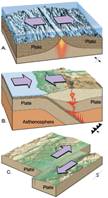
Plate TectonicsThe terrain that can be seen by traversing through the eastern region of California tells a complicated story in regards to how it was formed. At the heart of this story are plate tectonics, which is the concept that the Earth’s crust, and partially its’ mantle, are divided into large plates, with many smaller ones running throughout. The crust and the part of the mantle that are included in this concept can be lumped together into one division called the lithosphere, which slides across the lower layer of the mantle, called the asthenosphere. The plates that compose the Earth’s crust run through continents and oceans and carry oceanic crust on them. (Although not all of the plates have continents on them, most do.) These plates have been located and identified by viewing the boundaries they form when they meet or move away each other (Hill, 135-137). Depending on their movement the plates form convergent, divergent, or transform boundaries (Hill, 140) (fig. 1).
Figure 1. From top to bottom, a divergent boundary, a convergent boundary, and a transform boundary. Plate Tectonics. Web. 01 June 2010. <http://sciencerocks-platetectonics.blogspot.com/2009/04/how-well-do-you-know-earth-take-our.html>.
The plate that the Basin and Range province of Eastern California sits on is called the North American Plate. The western region of the North American Plate sits along a boundary with another plate, called the Juan de Fuca plate, a remnant of the Farallon Plate, which subducted under the North American plate, forming an area of uplift and volcanic activity in California (Hill, 146).
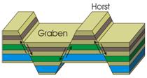
Due to tectonic activity, the Basin and Range province is even more complicated in that it has been stretching in a Northwest direction for approximately the last 25 million years. The pulling action that this area has experienced is still occurring to this day at about 3mm per year, and even faster in other parts of California. Because of this stretching, the area has increased in width by about 100 percent and has produced a series of normal faults, associated with vertical crustal movements. The boundaries that these normal faults create can be seen in the changes in elevation; horsts, uplifts in elevation compose the ranges and grabens, drops in elevation, compose the basins of the Basin and Range province (Hamburger) (Fig. 2).
Figure 2. Diagram of a horst and graben. "Tectonic Structures: GEOG 102." Web. 01 June 2010. <http://facweb.bhc.edu/academics/science/harwoodr/Geog102/study/tecton1.htm>.
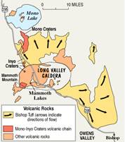
The formation of the Basin and Range province also resulted from periods of volcanic activity that created many of the dramatic landforms seen today in the area. One of the first episodes occurred in the early Tertiary and is called the Long Valley eruption. These volcanic eruptions distributed rhyolitic ash and other debris throughout the northern and eastern Sierra and were consolidated over time to form “tuff” (Hill 264). One stunning example of this can be seen in the Bishop Tuff (fig. 3), a 200m thick, consolidated tableland of this rhyolitic ash that spans from Long Valley to the town of Bishop, nearly 40 km south of Long Valley (Hamburger, Bishop). The next series of eruptions produced mass quantities of andesitic lava that mixed with water, created mudflows, formed granite and metamorphic rocks/boulders, and covered more than 12,000 square miles of the Sierra (Hill 269).
Figure 3. Map showing location and size of Bishop Tuff, Long Valley Caldera, and the Inyo and Mono Craters."Living With a Restless Caldera, Long Valley, California, Volcano Fact Sheet." USGS Publications Warehouse. Web. 02 June 2010. <http://pubs.usgs.gov/dds/dds-81/Intro/facts-sheet/fs108-96.html>.
The volcanic activity that had been so prevalent in the Basin and Range province quelled for a short time and then started up again in the Long Valley area around 3.6-2.5 million years ago (Hill 270). The landforms that were active this time were domes and craters. Ancient relics of these landforms dot the Basin and Range and can still be seen today including Glass Mountain, Panum Crater, and the Inyo and Mono Craters (fig. 3). But, the volcanoes were not just constructional features that added material to the Earth; some were destructional features. About 750,000 years ago the thin crust of Earth that was covering a magma chamber in the Long Valley cracked allowing lava, rock, and other debris to be ejected. As a result of this sudden loss of material in the magma chamber, the roof collapsed and created a depression in the land called a caldera. The caldera, which spans approximately 12 miles, is still present today (fig. 3) (Hill 271).
Glaciers
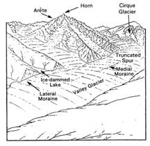
A colder phenomenon played a large role in forming the Basin and Range as well. Glaciers glided back and forth across the terrain of eastern California for about 1.5 million years, cutting, scraping, smoothing, and carving away at the land. After years of cold climates and snowfall, a glacier can form on a mountaintop. Due to gravity, the glaciers travel down the mountainside, carrying large boulders and other substrate with it and forming a variety of landforms as they move, grow, and finally recede back up the mountain. The landforms and evidence associated with glacial activity are prevalent throughout the Basin and Range province and include erratics, cirques, polishing, and moraines (fig. 4).
Figure 4. Cartoon depicting some of the landforms associated with glacial activity. "GEO_PLATE_G-8.HTML." Wydzia³ Nauk Geograficznych I Geologicznych / Faculty of Geosciences. Web. 01 June 2010. <http://geoinfo.amu.edu.pl/wpk/geos/geo_9/GEO_PLATE_G-8.HTML>.
Erratics are pieces of rock that have been carried a distance by glaciers and then dropped when the glacier started to recede. They are fairly easy to spot because they rarely match up with the surrounding rock types and seem out of place. Cirques are gently sloping, semi-bowl shaped walls that occur at the top of a mountain where the glacier had set and then melted. Sometimes a lake is in the bottom of the bowl where the last of the glacier sat. Glacial polishing occurs when a glacier carrying small rock and silt on its bottom glides across a large slab of rock, creating a sandpaper effect and smoothing out the slab. Moraines, which seem to be the most common feature in the area, are formed when glaciers deposit a cornucopia of rock and silt, called glacial till. The till piles up into large mounds and hills that can be very steep; this is the moraine (Hill, 294-309).
The glaciers that carved out the Basin and Range started about 1.5 million years ago and were quite active in that time period. During colder times they would grow larger and travel down the mountainsides and during warmer times they would recede back up the mountainsides. This has been occurring since the glaciers first formed. Surprisingly, some of these ice giants still exist in locations such as Devils Postpile, Yosemite National Park, and Big Pine (Hill 315).
Erosion
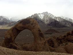
The process of erosion is something worth mentioning when discussing the formation of the Basin and Range province because it has been happening ever since wind and water came to be. The evidence of wind and water erosion can be seen all throughout the Eastern California area. In a place called the Devil’s Golf Course in Death Valley, wind and water erosion have worked together to form sharp spires of salt deposits that cover the ground. In place where outcrops are present, wind, and sometimes water, cut away at the softer, less dense rock, and create easy-to-find layers that can then be dated and observed. Examples of this have been seen in places such as the Bishop Tuff outcrops, Mosaic Canyon, and the Black Point fissures. In other places, such as the Alabama Hills, wind can erode rock into beautiful, rounded formations that are much different from their original size and shape (fig 5).
Figure 5. Rock formation at Alabama Hills created by wind erosion. Personal Collection
Climates
Due to the extremely dramatic landscapes of the Basin and Range province, brought on by the processes described above, the climates can be drastically different, even within an area of a few miles.
The Basins-Death Valley
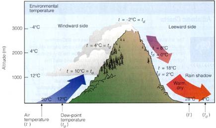
Flanked on either side by the Panamint Range on the West and the Black Mountains on the East, Death Valley is famous for being one of the hottest places on Earth. Temperatures reaching 120°F in the summer parch the valley. Coupled with an average rainfall of less than two inches, Death Valley is also one of the driest places on Earth (Death). A process called rain shadow is the reason this particular region has such extreme temperatures. Storms do in fact occur in the area, coming from the Pacific coast, but when they get over the Panamint Range the clouds have no moisture in them any more. As they rise in elevation, the moisture condenses and then falls from the clouds in the form of snow or rain. When the clouds reach the valley there is no more moisture to precipitate out of them (fig 6.) Death Valley experiences such extreme heat not only because of the rain shadow, but also because of its low elevation. Badwater, which is located in Death Valley, boasts the lowest elevation in the United States, 282 feet below sea level. Heat from the sun is cast into the valley and becomes trapped in the low elevation. As the air rises it is cooled only slightly and then brought back down into the valley where it condenses and heats back up (Death).
Figure 6. Cartoon depicting the process of rain shadow including approximate elevations and temperatures."Basin and Range Climate and Vegetation." UC Santa Barbara Geography. Web. 03 June 2010. <http://www.geog.ucsb.edu/~joel/g148_f09/lecture_notes/basin_range/basin_range_veg.html>.
The Ranges
The ranges of the Basin and Range province have more than one climate zone due to the elevation that they possess. In fact, as the elevation rises in 1000 foot increments, the temperature correlates and drops 3-5°F (Death). With the highest point in the Basin and Range being 14,505 feet above sea level, the temperatures can be bitter cold. A climate zone characterized as Mediterranean belongs to the ranges of Eastern California. Temperatures range from 26°F-64°F, much colder than that of Death Valley and the rest of the Basins. Elevations of the Mediterranean zone encompass 2,000-6,000 feet above sea level. There is precipitation in this area because rain shadow occurs at lower levels of elevation and it is usually in the form of rain. Climbing higher up into the ranges the climate zone called the boreal exists. The elevation in this zone is somewhat higher and encompasses land 6,000-12,000 feet above sea level. The temperatures here can be anywhere from 26°F-50°F. The summer months are typically cool and dry and the winter months see heavy snow/rain and are quite cold. The highest climate zone that the ranges possess is the polar climate zone and it is associated with heavy snowfall, temperatures less than 50°F in the warmest months, and elevations above 12,000 feet (Climate).
Wildlife
The wildlife in the area correlate with the pattern of complexity the Eastern region of California seems to have. With the numerous climate zones and geographic landforms that the area has to offer, plants and animals of all types are able to flourish and create their own niche. Unique adaptations have allowed every part of the Basin and Range to be inhabited by some living creature and each one of them are stunning examples of natural selection. From the saline lakes of the basins, to the alpine regions of the mountains, there seems to be plants and animals successfully living, reproducing, and thriving.
Endemic Species
Species that are known to inhabit a specific area of the world and that are only found in that area are known as endemic species. Eastern California is home to quite a few of these unique plants and animals. In Death Valley alone there are many plant and animals species that are only found within the boundaries of the national park. Included in this category are plants such as Holly-leaved spurge (Tetracoccus ilicifolius), Death Valley Monkeyflower (Mimulus rupicola), and Rock lady (Maurandya petrophila). There are also endemic animal species including the Panamint Alligator Lizard (Gerrhonotus panamintinus), Salt Creek Pupfish (Cyprinodon nevadensis amargosae), and the Pygmy Pocket Gopher (Thomomys umbrinus oreocus) (Death, Plants). Even the alkaline waters of Mono Lake, until recently considered a “dead lake”, are home to an endemic species of brine shrimp that number in the billions.
Vegetation
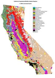
Due to the varying climate and geographic ecoregions of the Basin and Range, the vegetation can rapidly change within a few miles radius. Just within Death Valley National Park there are more than 1,000 plant species (Death, Plants). The zones of vegetation, just like the climate and geology of the region, change with elevation (fig. 7). In the lower elevations, subtracting the salt flats because nothing grows or lives there, creosote bushes, desert holly, and sagebrush, which are easily identified by their pungent aroma, cover the sandy floor. Joshua trees and juniper bushes are common throughout the area in this lower elevation as well (Spellenberg). Traveling higher in elevation to the subalpine level, Limber Pine, Jeffrey Pine, Pinyon Pine, and Bristlecone Pine, which are the oldest trees in the world (up to 5,000 years) are quite common (Little, Cones).
To inhabit the harsh climates and ecosystems that these plants live in, a long process of natural selection has occurred and has left amazing adaptations with the plants. The Joshua tree (Yucca brevifolia) is an evergreen that ranges from 15-30 feet in height and 1-3 feet in diameter. It has sharp, narrow leaves held by a small trunk and small branches. It inhabits the Mohave Desert of Utah, Nevada, California, and Arizona at elevations of 2000-6000 feet above sea level (Little 328-9). The sharp, narrow leaves of the Joshua tree enable it to conserve the maximum amount of water, which is quite advantageous in its arid climate. This leaf shape also protects the tree from the harsh sunlight. If the leaves were broad, the sun would burn them and evaporation would happen at a quicker rate. The Pinyon (Pinus edulis) has similar adaptations to the dry foothills that it inhabits. It stands at about the same height as the Joshua Tree (15-35 feet) and also has about the same diameter (1-2 feet). The tree itself is resinous with thick, short cones that produce thick and oily seeds. Because the Pinyon is resinous, this helps it to retain water and protect it from evaporation, just as the Joshua tree. The thick, oily seeds that drop from the Pinyon are that way so they can withstand the arid climate as well (Little 276). Every trait the Pinyon and the Joshua Tree possess is used for their survival and protection in the desert climate of the lower elevation Basin and Range.
Figure 7. Map showing vegetation zones of California. "California Maps - HSU Library." Humboldt State University Library. Web. 04 June 2010. http://library.humboldt.edu/~rls/geospatial/calmaps.htm.
Climbing higher in elevation to the Bristlecone and Jeffrey Pine forests, adaptations are numerous as well. Although the elevation zone of 7500-11,500 feet above sea level where these pines are found gets more precipitation, it is much colder. The thick trunk of the Bristlecone pine protects the water and minerals inside of it from freezing. The short needles also protect the water and the tree from freezing and from losing too much water via evaporation (Little 270).
Animals
The diverse plant life that is common in the Basin and Range of eastern California is crucial for the survival of the animals that inhabit the area. In fact, the two depend on each other to survive, reproduce, and prosper every day. In Death Valley National Park, although it is considered one of the hottest places on Earth, animals are quite plentiful. Amphibians such as the Red-spotted Toad (Bufo punctatus) and the Pacific Treefrog (Pseudacris regilla) live in the sparse water that is in the park (Wernert 192). Places to find these animals would be Furnace Creek and Hanaupah, where water is present (Death, Animals) Reptiles, which are more suited to the intense heat of the environment, are more common. Chuckwallas (Sauromalus obesus) are one of the larger reptiles that can be found in the area, ranging from 11-16.5 inches in length. Their habitat consists of the many alluvial fans and rocky outcrops that the area has to offer. The Chuckwalla digests the many wildflowers and leaves that the desert floor provides. This reptile also uses the thin crevices of the rocky outcrop layers to its advantage. When threatened, it will puff up its body so it is wedged in the crevice. From this vantage point it can rarely be seen or extracted from the layer. The sagebrush that blankets the basin floor provides good cover for another reptile, consequently named the Sagebrush Lizard (Sceloporus graciocus). This lizard is considerably smaller than the Chuckwalla, ranging from 5-6 inches in length (Wernert 168). But, it inhabits a much larger area spanning the basin floor, all the way to the mountain range forests up to 10,500 feet in elevation (Death, Animals). Also, the diet of the Sagebrush Lizard is similar to the Chuckwalla (Wernert 168).
The birds of the Basin and Range are in extreme abundance, specifically on Mono Lake because the lake provides a resting place for many of the migratory birds that fly over the area. Grebes, loons, egrets, and ducks are common avian inhabitants of Mono Lake. Although there are no fish in the lake, billions of saline flies and brine shrimp are for the hunting and there are other freshwater lakes surrounding Mono that provide sufficient food sources (Death, Animals).
Small mammals in the Basin and Range are almost just as abundant as the birds. Small mammals like the Desert Shrew (Notiosorex crawfordi), the Desert Kangaroo Rat (Dipodomys deserti), and the Southern Grasshopper Mouse (Onychomys torridus) make their home in the lower, more arid elevations of the Basin and Range and have adapted well to their surroundings. The Kangaroo Rat does not even need to drink water, getting its water from the products of food digestion. These small mammals, and many others like them, are usually all brown, to blend into the sandy bottom of the Basin floor. Other small mammals like the Pygmy Pocket Gopher (Thomymus umbrinus oreocus) and the Pika (Ochotona princeps) inhabit higher elevations. The Pygmy Pocket Gopher lives in elevations up to 10,000 feet above sea level, frequently seen on Telescope Peak (Death, Animals). The Pika, more closely related to the rabbit than the rodent, makes its home on the rocky slopes of lower elevation hills and mountains (Wernert 56). They have been closely studied due to the complicated communication and social structure they possess. All of these small mammals are very important to the survival and reproduction of many seed plants that cover the area. In higher elevations the small mammals disperse pine seeds throughout the area via feces and allow for Jeffrey Pines and others to grow in places where they usually would never be able to reach (Briggs).
Larger mammals include the coyote (Canis latrans), Mountain lion (Felis concolor), and the bobcat (Lynx rufus). These carnivorous mammals feed on the smaller mammals that are found in the Basin and Range. The coyote and the bobcat are common from the basin and into the lower ranges of the Basin and Range. But, the mountain lion rarely leaves the mountain ranges unless to get water in the winter from lower elevations oases. Larger herbivorous mammals include the Bighorn Sheep (Ovis canadensisi) and the Mule deer (Odocoileus hemionus). The mule deer can be found in mountain ranges such as the Panamint and Cottonwood Mountains but the Desert Bighorn Sheep are found at most elevations in the Basin and Range. They prefer to travel along the canyons and outcrops that most other mammals cannot reach (Death, Animals). Due to the hoof structure of the Bighorn Sheep, which consist of a hoof that separates in half, this mammal can cling onto rocks and steep slopes that most others cannot (Wernert 66). These larger herbivorous mammals also help with plant seed dispersal throughout the region.
Conclusion
The facts, observations, and evidence provided above supports the conclusion that the geology, climate, and biology of the Basin and Range of eastern California are all strongly connected in many ways. The geologic history of the Basin and Range correlate with the fact that the climate and the wildlife of the area are a complicated mix and change quite consistently as the elevation rises from the floor of Death Valley to the mountain ranges of the east and west and the plants and animals of the Basin and Range possess fascinating adaptations for the extreme conditions of climate and topography that stem from the early formation of the land. Almost all landforms of the Basin and Range provide shelter or safety for the biota, all are set in a certain climate range, and all are the consequence of some geologic process. The Basin and Range of eastern California truly is a geological, climatological, and biological amalgamation.
________________________________________________________________________
RESOURCES
"Basin and Range Climate and Vegetation." UC Santa Barbara Geography. Web. 29
May 2010. http://www.geog.ucsb.edu/~joel/g148_f09/lecture_notes/basin_range/basin_range_veg.html."Basin and Range Region." UC Santa Barbara Geography. Web. 28 May 2010.
http://www.geog.ucsb.edu/~joel/g148_f09/readings/basin_range/basin_range.html“Bioimages.” Forwarding Link. Web. 28 May 2010.
http://www.cas.vanderbilt.edu/bioimages/ecoregions/50527frame.htm.Briggs, Jennifer; Jenkins, Stephen; Vander Wall, Stephen. “Forest rodents provide direct
dispersal of Jeffrey pine seeds.” Ecology, 90(3), 2009, pp. 675–687.
http://kg6ek7cq2b.search.serialssolutions.com/?sid=CSA:objectsclust-ear-set-c&pid=%3CAN%3E301%2D0004730525%3C%2FAN%3E%26%3CPY%3E2009%3C%2FPY%3E%26%3CAU%3EBrjggs%2C%20JS%3B%20Wall%2C%20SBV%3B%20Jenkins%2C%20SH%3C%2FAU%3E&issn=0012%2D9658&volume=90&issue=3&spage=675&epage=687&date=2009%2D03&genre=article&aulast=Brjggs&auinit=JS&title=Ecology&atitle=Forest%20rodents%20provide%20directed%20dispersal%20of%20Jeffrey%20pine%20seed."California Maps - HSU Library." Humboldt State University Library. Web. 04 June
2010. http://library.humboldt.edu/~rls/geospatial/calmaps.htm."Climate of the Sierra Nevada." Sierra Nevada Photos - Home Page. Web. 29 May 2010.
http://www.sierranevadaphotos.com/geography/sierra_climate.asp."Death Valley National Park - Animals (U.S. National Park Service)." U.S. National
Park Service - Experience Your America. Web. 08 June 2010. http://www.nps.gov/deva/naturescience/animals.htm."Death Valley National Park - Plants (U.S. National Park Service)." U.S. National Park
Service - Experience Your America. Web. 04 June 2010. http://www.nps.gov/deva/naturescience/plants.htm."Death Valley National Park - Weather and Climate (U.S. National Park Service)." U.S.
National Park Service - Experience Your America. Web. 03 June 2010. http://www.nps.gov/deva/naturescience/weather-and-climate.htm.Hamburger, Michael. “The Bishop Tuff”. 2010. Print.
Hamburger, Michael. “The Basin and Range Province”. 2010. Print.
Hill, Mary. Geology of the Sierra Nevada. Berkeley: University of California, 2006.
Print.Little, Elbert L. National Audubon Society Field Guide to North American Trees,
Western Region. New York: Alfred A. Knopf, 2000. Print.Schoenherr, Allan A. A Natural History of California. Berkeley: University of California,
1992. Print. http://books.google.com/books?id=hk66OIHoesEC&printsec=frontcover&dq=isbn:0520069226&cd=1#v=onepage&q=Sierra%20Nevada&f=false.Spellenberg, Richard. National Audubon Society Field Guide to North American
Wildflowers: Western Region. New York: Knopf, 2004. Print."Terrestrial Ecoregions -- Sierra Nevada Forests (NA0527)." World Wildlife Fund –
Wildlife Conservation, Endangered Species Conservation. Web. 28 May 2010.
http://www.worldwildlife.org/wildworld/profiles/terrestrial/na/na0527_full.html."USGS Geology in the Parks." Western Region Geology and Geophysics Science Center.
Web. 29 May 2010. http://geomaps.wr.usgs.gov/parks/province/basinrange.html.Wernert, Susan J. Reader's Digest North American Wildlife. Pleasantville, N.Y.: Reader's
Digest Association, 1982. Print.