Geology and Natural Heritage of the Long Valley Caldera
The Effects of Hydrothermal Processes on Groundwater and Mineral Deposition in the Eastern Sierra Nevadas
Mackenzie Kirchner-Smith
Abstract
The Long Valley Caldera area is well known for its geothermal processes. Geologically, water affects and is greatly affected by the geothermal processes and mineral deposits that are found in this Eastern Sierra Nevada region. The volcanic activity found there is in large part the reason for the movement, heat, and mineral content of the water that in turn shapes the landscape. The nearby magma chambers and intrusions that are found throughout the Long Valley Caldera area are what heat the underground water table, making it easier for minerals from the surrounding bedrock to dissolve and later be deposited when the water cools again nearer to or on the surface as it escapes in hot springs and fumaroles. When the water is heated by a magma source and then cools it can leave deposits of gold, silver, kaolin, iron, and various other mineral formations in the surrounding rock. Sometimes this mineral rich water comes in contact with bodies of water, as in Mono Lake. The lake has its own chemical makeup, and when mixed with the content of this fresh water will form structures known as tufa towers that are mineral deposits of another kind.
Introduction
Hydrology is the study of surface, ground, and atmospheric water and its properties and effects. The groundwater in Long Valley Caldera is most affected by the surface bound magma throughout the region, such as in the Hot Creek Gorge, Little Hot Creek, and in the hot springs around Crowley Lake and Mammoth Mountain [USGS Long Valley Website 2010]. In these places pools of hot water that have a heavy concentration of minerals can be found, as well as surrounding rocks that have discoloration due to deposition of these materials precipitating out as the water cools in steam vapors or from contact with the cooler surface air or rock away from the magmatic source of heat. Areas such as these are related to the welling up of water from underground, which is why these springs are so hot as compared to runoff streams and lakes. The Long Valley magma chamber is the original source of this heat, and as the water percolates through the rock and water slowly it moves in much the same way the semi-liquid rock mantle just beneath the Earth's crust does, causing a slow convection of hot water that rises from the heat source as its pressure in the surrounding rock increases, then begins to cool again as the water leaves the heat. This process allows the minerals to precipitate out to form veins of deposited material that are found commonly in faults and other areas where the ground is likely to crack. Once the water has cooled enough, it either sinks back down to the place it was first heated or finds its way to the surface. It is this process that results in the abundance of minerals found in the Sierra Nevada mountains.
Geothermal Activity
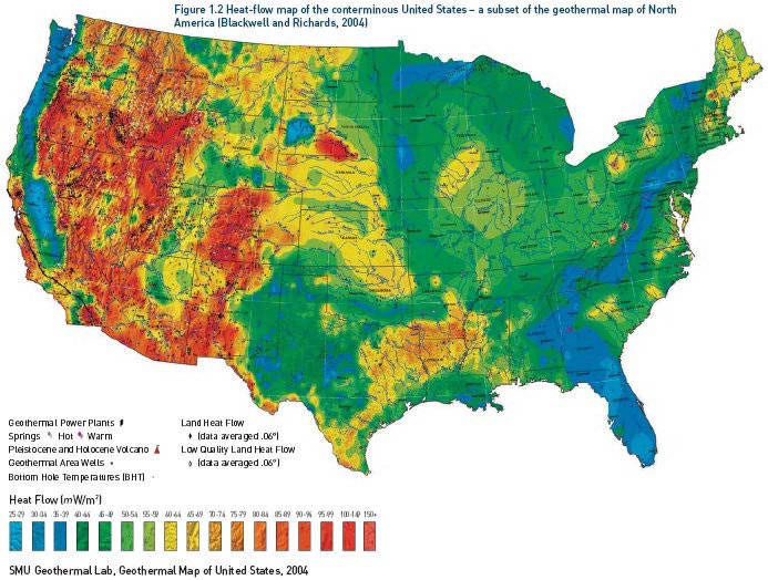
Much of the Long Valley and Sierra Nevada region are volcanic in nature due to the former subduction of the Farallon Plate beneath the North American Plate around 20 million years ago. Potential for an eruption still exists even though the Pacific and North American Plate are now sliding past each other instead of colliding to subduct: the chambers were large enough to leave behind magma that remains active through the region, and volcanic activity is still common as can be seen by the map in Figure 1. [pubs.usgs.gov/gip/dynamic/Farallon.html]. The Long Valley Caldera is a crater left behind when a supervolcano erupted, causing the land to cave in because so much material was ejected. This land is now riddled with remnants of the events in the form of ash, tuff, and other volcanic material from eruptions over millions of years. Due to the nature of such a volcanic landscape, there are varying degrees of volcanic activity based on how close the magma is to the surface of the Earth, as elevation changes throughout the Valley. This can help determine where water is able to interact with the heat of the magma, and where certain landforms will appear based on how close the magma comes to the surface of the Earth which in turn changes how often water comes in contact with this heat.
Figure 1: Map of geothermal heat flow for the United States. Figure reproduced from Blackwell and Richards [2004].
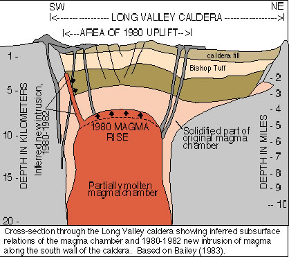
Figure 2: Cross-section of Long Valley Caldera showing caldera magma chamber. Modified from Bailey [1983].
Aquifers and Groundwater
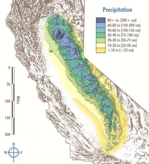
Groundwater in the Sierra Nevada region is widespread and often contained in aquifer systems throughout the mountain ranges. Water flow is dependent on the amount of water that the Sierra gets each year, which can very widely depending on temperature and yearly precipitation. The average annual rainfall for the Sierra Nevada region varies from less than 10 inches to a max of about 80 inches as you go more towards the Northern end of the mountain range. The layers of water found underground include the zone of aeration, the water table, and the zone of saturation respectively going progressively deeper. The zone of aeration is the top layer, which does not hold as much water, instead it consists of mostly air between the rock and sediment. This region can vary in depth depending on the amount of rainfall an area gets. The zone of saturation holds the most water, with the highly saturated water table above it. [Science Clarified, 2003] It is in the zone of saturation that aquifers would be found given the amount of water held there. Two main aquifers seem to be the most prominent within the Long Valley Caldera, their water interacting with a magma source in the form of an intrusion or magma chamber, with water flows that go from East to West along the Sierras [Pribnow, et al., 2003].
Figure 3: Annual Precipitation map for the Sierra Nevada Mountain Range. Adapted from Atlas of California [1979].
Groundwater Movement
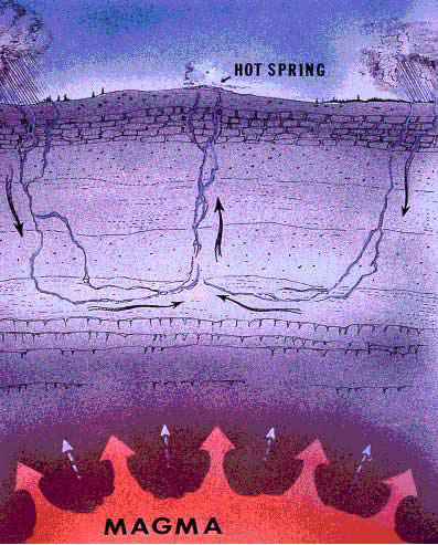
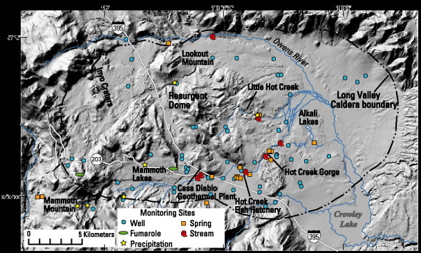
As the groundwater comes in contact with magma heated rock and areas, the pressure of the water in relation to the surrounding rock increases and the heated water expands. [Hanor, 1980]. This hot water in turn pushes down the cooler more dense water until it becomes a cycle of convection as shown in Figure 4, making for a loop that keeps hot water returning to the surface as cool water nears the magma and hot water cools and descends again <http://theory.uwinnipeg.ca/mod_tech/node76.html>. Depending on the amount of heat still in the water by the time it reaches the surface, it can either pool as hot water to form a hot spring, or in cases of much hotter water, flash into steam once it reaches the surface to create a fumarole. Below, seen in Figure 5, is a map of fumaroles, hot springs, and geothermal wells that are found in Long Valley, showing the abundance and placement of these landforms in relation to magma sources. Many of the springs are located at lower points of the Valley, as they leave the heat near the resurgent dome or other magma sources around the Long Valley Caldera.
Figure 4: Underground water convection cycle model. Reproduced from[http://mms.nps.gov/yell/ofvec/exhibits/eruption/water/index.htm]
Figure 5: Map of hot springs and fumaroles within and near the Long Valley Caldera. Reproduced from USGS Long Valley Website [2010].
Mineral Deposition
Another effect of having highly heated water move through rock is the change in the water's ability to dissolve minerals. At high water temperatures, the solubility of minerals increases, and many metals and minerals normally found only deep in the Earth are dissolved into the hot water and carried closer to or on the surface of the Earth. California is well know for its history of gold mining, and that is largely due to the fact that there is so much geothermal activity in California.
Mineral deposition occurs as a result of this convection cycle. As the hot water moves to the surface it reaches cooler rocks, and the water becomes less able to hold a high level of mineral content as it cools. These minerals then precipitate out as ore deposits, which are deposits in the cracks between the rocks that leave behind veins of minerals normally found deep in the Earth. This process of deposition is also known as hydrothermal alteration, when a rock is changed by the addition of something brought by water that is heated underground by geothermal processes [Introduction to Exploration Geology]. Mineral deposits change the overall composition of the rock by adding additional
minerals to the rock, sometimes within in microscopic veins in the rock, sometimes just on the surface, causing a variation in color, depending on the mineral being deposited.
The minerals that the water has picked up in the area it traveled through determine what deposits can be found at both fumarole and hot spring sites. The most well known and often highly regarded deposit is gold, but other metals like iron, silver, and copper can be found in these ore deposits as well. Sometimes non-metallic minerals like sulfur can be seen, especially in areas closer to magma chambers. Sometimes near fumaroles a rotten egg smell can be observed, as well as yellow staining on walls near the steam vent from sulfur deposition. Some mineral deposits can even build up into towers, like the tufa towers of Mono Lake. These calcium carbonate towers are formed by hot, calcium rich freshwater springs beneath the lake that combine with the alkaline, saline water of Mono Lake to form Ca(CO3) – essentially limestone – that precipitates out and makes these underwater structures which are revealed only when the water level drops enough to expose the towers [About Mono Lake: Tufa Towers].
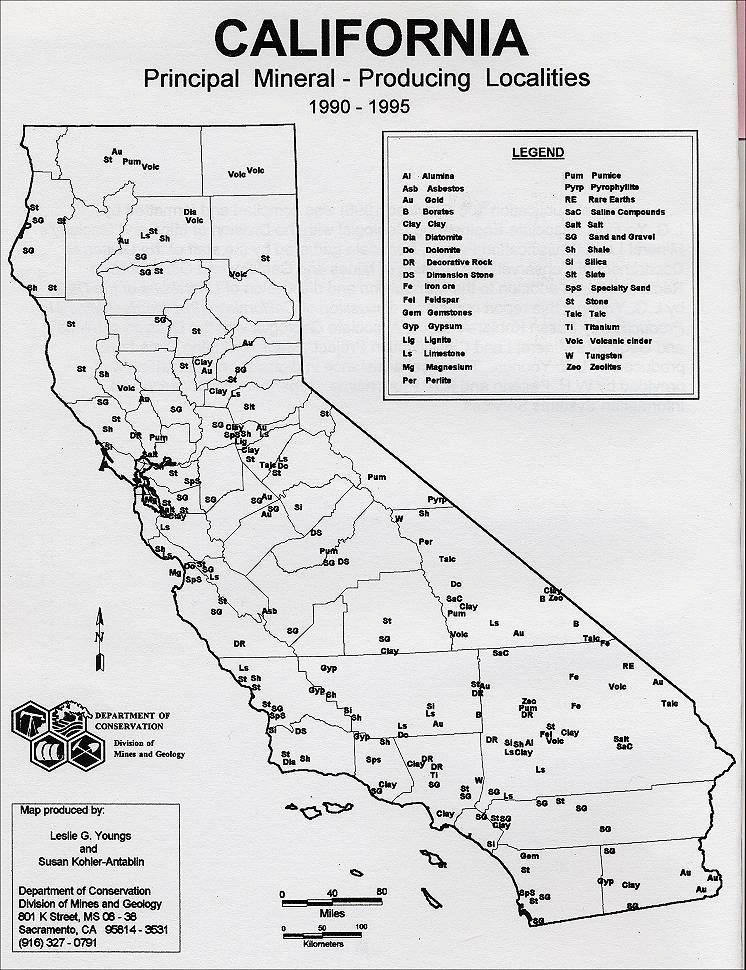
Figure 6: Map of California Mineral dispersal. Reproduced from The California Stone Industry [1990-1995]
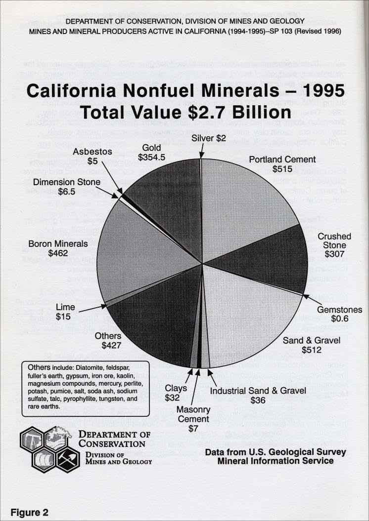
Figure 7: Pie diagram of non-fuel mineral revenue for California, 1995. Adapted from The California Stone Industry [1995].
Shape of the Land
It is due to processes like these that the land has been so uniquely shaped and adorned, particularly in places like California. Multicolored mountains, canyons, and cliffs grace the landscape because of the mineral deposits found here. Geothermal heat drives the process of water movement in the Sierra Nevada mountain range, bringing hot water in the form of springs and fumaroles to the surface of the Earth. Ore deposits have been an important part of California's history as a place of profit and fortune for many, and the unique combination of mineral deposits found there are a result of hydrothermal alteration, the movement of the water heated to extreme levels, dissolving minerals we wouldn't normally imagine could dissolve into water and carrying them often great distances towards the surface.
Water shares this convection of heat with the mantle of the Earth, which slowly drives the plate tectonic process and moves the partially liquid rock just beneath the Earth's crust in a heating, cooling, reheating, re-cooling cycle that moves the plates. Tectonic activity then produces magma near the Earth's surface in places like the Sierra Nevada Range, where the water is then heated, in a continuous cycle of processes that work off of one another. These seemingly simple landforms, pools of hot water from the ground, take enormous amounts of energy and many separate events working together to form, making them more complicated, powerful and unique than they may appear at first glance.
Resources
Bailey, R. A., 1976, Volcanism, Structure, and Geochronology of Long Valley Caldera, Mono County, California. Journal of Geophysical Research, v. 81, p. 725-744, https://oncourse.iu.edu/access/content/group/SP10-BL-GEOL-G190-7360/Final%20project%20resources/Long%20Valley%20Caldera%20geology/Bailey_JGR_1976.pdf, (June, 2010).
Bales, R., and Rice, B., The Sierra Nevada Hydrologic Observatory, The Sierra Nevada Hydrologic Observatory, Web. 8 June 2010, https://eng.ucmerced.edu/snri/snho/snho_web/index.html, (June 2010).
Convection, Theoretical Physics at the University of Winnipeg, http://theory.uwinnipeg.ca/mod_tech/node76.html, (June 2010).1999, Farallon Plate [This Dynamic Earth, USGS], USGS Publications Warehouse, http://pubs.usgs.gov/gip/dynamic/Farallon.html, (June 2010).
Geyser and Hot Spring - The Shape of the Land, Forces and Changes, Science Clarified, http://www.scienceclarified.com/landforms/Faults-to-Mountains/Geyser-and-Hot-Spring.html, (June 2010).
Hanor, J. S., 1980, Hot Springs: In Hot Water, National Park Service and U.S. Department of the Interior, http://www.nps.gov/hosp/naturescience/upload/inhotwater06-2.pdf, June 2010.
Hydrologic Studies in Long Valley Caldera, USGS: Science for a Changing World, http://volcanoes.usgs.gov/index.php, (June 8, 2010).
Hydrothermal Veins and Alteration, Delta Mine Training Center ALASKA, http://www.dmtcalaska.org/course_dev/explogeo/class08/notes08.html, (June 2010).
Pribnow, D. F. C., Schutze C., Hurter S. J., Flechsig C., and Sass J. H., 2003, Fluid £ow in the Resurgent Dome of Long Valley Caldera: Implications from Thermal Data and Deep Electrical Sounding, Journal of Volcanology and Geothermal Research, v. 127, p. 329-345, Science Direct, http://www.uni-leipzig.de/~geo/pde/projekte/downloads/LVC_paper.pdf, (June 2010).
Tufa Towers: Mono's Magnificent Monuments, Mono Lake Committee, http://www.monolake.org/about/geotufa, (June 2010).
Wheelock, S., 2003, A Comparison of the Long Valley and Valles Caldera Hydrothermal Systems in the Western United States, The Water Geeks, http://www.watergeek.net/geek/Volcanology.pdf, (June 2010).
Figure 1 - http://thinkgeoenergy.com/archives/1294
Figure 2 - http://volcano.oregonstate.edu/vwdocs/volc_images/north_america/california/long_valley.html
Figure 3 - http://www.sierranevadaphotos.com/geography/sierra_precipitation.asp
Figure 4 - http://mms.nps.gov/yell/ofvec/exhibits/eruption/water/index.htm
Figure 5 - http://volcanoes.usgs.gov/lvo/activity/monitoring/hydrology/index.php
Figure 6 - http://quarriesandbeyond.org/states/ca/images/ca_books/ca-mines_and_mn_1995-96/ca-mines_and_min_1995-6_map_piv_fig1.jpg
Figure 7 - http://quarriesandbeyond.org/states/ca/images/ca_books/ca-mines_and_mn_1995-96/ca-mines_and_min_1995-6_nonfuel.jpg