Geology and Natural Heritage of the Long Valley Caldera
The Mono-Inyo Crater/Dome Chain of Long Valley Caldera/Mono Basin Region of the Eastern Sierra Nevada
Cassie Geraghty
Abstract
The Mono-Inyo Crater/Dome Chain contains some of the youngest, of many, volcanic features within the Long Valley Caldera/Mono Basin Region of the Eastern Sierra Nevada. The chain’s phreatic craters were caused by the explosive interaction between water and magma. The domes were secondary effects, created by the highly felsic/viscous magma which rose through the newly created vents, causing the ground above to push upwards. Sometimes these domes erupted into slow moving lava oozes called “coulees.” Characteristic igneous deposits within the Mono-Inyo Crater/Dome chain include highly felsic pumice and obsidian. Volcanic activity within the entire region—including the Mono-Inyo Crater/Domes seems to be moving to the north-northwest. With this knowledge, scientists believe that future eruptions will take place within the Mono-Inyo region.
Introduction
The Long Valley Caldera/Mono Basin region of the Eastern Sierra Nevada is rich with past and present volcanic activity. One such striking, volcanic feature in this area is the Mono-Inyo Crater and Dome Chain.
Volcanic Domes
Volcanic domes are identifiable as large, rounded, hill-like volcanic landforms. Unlike highly gaseous felsic magma, which can build up enormous amounts of pressure underneath the ground, eventually leading to violent eruptions, domes are made up of felsic magma that is low in gas. Magma low in gas equates to magma that is low in pressure, allowing it to slowly ooze upwards, deforming the ground overlaying it into a hill. Sometimes the oozing magma “quietly” erupts into coulees—a dome’s slow, oozing lava flows—which cool rapidly into the likes of obsidian and pumice, depending on gas content.
Volcanic Craters
Volcanic craters look exactly what they sound like—craters. They are more commonly seen at the vents of giant volcanoes, but others can be caused by (geologically) quieter volcanic phenomenon. One such phenomenon would be a phreatic explosion: these are steam blasts detonated by fierce interactions between ground water and magma. The intense force with which the steam shoots from the ground leaves a crater (United States Department of Agriculture Forest Service, Panum Crater).
Mono-Inyo Crater/Dome Chain
Volcanic domes and craters make up the Mono-Inyo volcanic chain in the Long Valley Caldera/Mono Basin region of the Eastern Sierra Nevada. The Mono-Inyo chain is thought to be the product of an elaborate fault system—within the earth—“…(T)he northwest trending Sierran frontal fault zone…” (Bailey, 1989). These “cracks” in the ground are assumed to be passageways and tunnels for different bodies of magma, associated with local active volcanism, to flow through. From here, the magma can rise and erupt at different areas along this fault system, at different time periods—as in the Mono/Inyo chain.
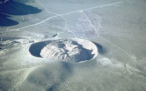
Mono Craters and DomesAt 17-kilometers in length (Hill, Mary, 2006), the Mono Crater/Dome chain (Figure 1) is “the youngest mountain chain on the continent (Tierney),” last active only 40,000 years ago (Irwin, 1991). The Mono chain is the result of phreatic explosions, and rising magma pushing the ground upward, creating domes and emitting coulee eruptions. These volcanic mountains are known for their highly felsic composition, making it an in-demand place for mining pumice (Irwin, 1991).
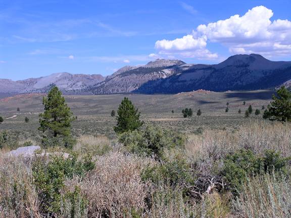
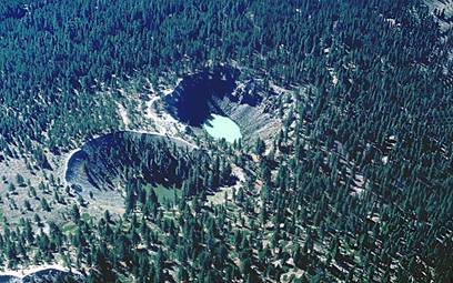
Figure 1. Mono Craters/Dome volcanic chain (Mono Craters).Panum Crater and Dome (Figure 2), the latest creation in the Mono chain, formed around 600 years ago (United States Department of Agriculture Forest Service)—the result of a phreatic explosion. This was followed by the formation of a dome, which continuously erupted coulees until its rest in 1445 A.D. (Hill, Mary, 2006).
Figure 2. Panum Crater and dome (Panum Crater and Lava Dome, 2009).The igneous rocks of Panum Crater are a peculiar mixture of vesicular pumice and glassy obsidian. Samples include both pure pumice and pure obsidian. There are also sedimentary variations, with multiple layers of pumice and obsidian alternating side by side as a result of consistency—high silica magmas do not mix well because they are very viscous. When there are both gas-rich and gas-lacking viscous magmas traveling beside one another, they are not likely to mix. Rather they will flow side by side—hence, the sedimentary pattern. Even so, there are not always heterogeneous combinations: in Panum Crater there are many examples (with probably the majority of the igneous rocks there) of pumice and obsidian mixing together, creating a silvery, vesicular, glassy, homogeneous structure. It is quite a beautiful phenomenon to see.
Inyo Craters and DomesJust like the Mono volcanic chain, phreatic craters and highly felsic domes characterize the Inyo chain; the only major difference is that there are no domes inside of the Inyo craters (though there are several craters within one of Inyo’s domes) (Long Valley Caldera Field Guide-Inyo Craters, 2010). The older Inyo domes, North Deadman Creek (which erupted around 6,000 years ago) and Wilson Butte (which erupted around 1,350 years ago) are surprisingly of the same chemical composition and approximately the same age as the Mono craters and domes, so they probably shared the same body of magma beneath the earth (Hill, Mary, 2006). However, the rest of the Inyo domes have their own chemical composition and are much younger in age. According to Roy A. Bailey, in “Geologic Map of Long Valley Caldera, Mono-Inyo Craters Volcanic Chain, and Vicinity, Eastern California”:
The younger Inyo domes—Obsidian Dome, Glass Creek dome, south Deadman Creek dome, two smaller unnamed domes, and their associated tephras—all erupted within a span of probably no more than a few years, or possibly months…(t)hey commenced erupting after cessation of the northern Mono Craters eruptions, possibly A.D. 1368 [Sieh and Bursik, 198], and could be as young as A.D. 1472 [Miller, 1985]. (1989)Another unique characteristic of the Inyo chain is that in several of the Inyo Craters, water has collected creating the Inyo Crater Lakes (Hill, Mary, 2006) (Figure 3).
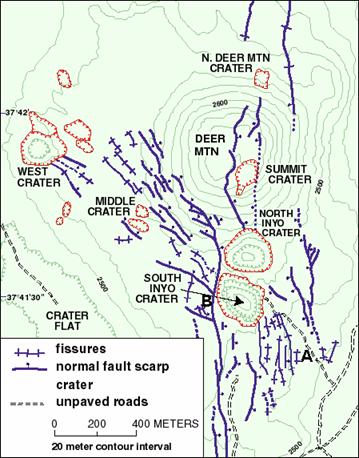
While the Mono craters and domes form a cohesive mountain chain, the Inyo chain is a little bit more spread out. There are several craters located on and around Deer Mountain, and also another group of craters which branch off to the northwest (Mastin, 1988). This creates a “fork in the road” path, unique to this volcanic chain (Figure 4).
Figure 3. Inyo Crater Lakes (Inyo Craters, 2009).
Figure 4. Inyo Craters and fault system (Map of Fissures
and Faults Near Inyo Craters, 2009).
Associated Volcanic Landforms
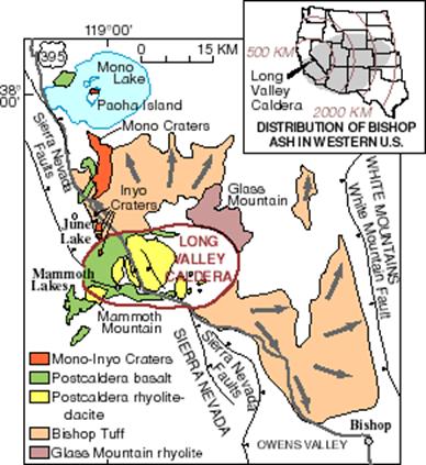
Besides the main Mono-Inyo Crater/Dome chain, there are other associated volcanic landforms in the immediate area (Figure 5), which also follow the Sierran Fault Zone. First and foremost—starting south—the Long Valley Caldera is the most prominent volcanic feature in this region, created almost 760,000 years ago (Hill, David, 1998). Next there is Mammoth Mountain, located on the southwest edge of the caldera; this dome-upon-dome finished erupting 50,000 years ago (Hill, David, 2000). Then heading northward—past the Mono-Inyo chain, and in the middle of Mono Lake—there is Paoha Island. According to “Volcanoes,” by Tierney, this island is a volcanic dome, topped by lake sediments, with an attached cinder cone; this is the youngest volcanic landform in the region, having erupted only 310 years ago. Negit, another island in Mono Lake, is a cinder cone, which erupted 1,600 years ago (Tierney). Lastly, the northern most volcanic landform associated with the Mono-Inyo chain is Black Point, a cinder cone originally formed 13,000 years ago under Mono Lake, when its waters were much higher (Mono Basin Scenic Area).
Future Volcanic Activity
There seems to be a pattern associated with the Mono-Inyo Crater/Dome chain and related volcanic landforms. Over time, eruptions have been drifting northward, getting smaller, and turning more mafic/less felsic. This leads scientists to believe that a future eruption in the Long Valley/Mono Basin region—which will inevitably happen
because of current volcanic activity including earthquakes, gas emissions, and ground deformation—will most probably be similar and within proximity to the smaller, geologically recent eruptions in the Mono-Inyo area (Hill, David, 1998).
Figure 5. Related volcanic landforms within Long
Valley/Mono Basin region (Long Valley Caldera,
Mono-Inyo, 2010).
Conclusion
All in all, the Mono-Inyo Crater/Dome chain is a unique feature among the diverse volcanic landscape in the Eastern Sierra Nevada. This chain’s past, present, and future has been, and will be for quite some time, rich with volcanic activity.Works Cited
Bailey, Roy A. Geologic Map of Long Valley Caldera, Mono-Inyo Craters Volcanic Chain, and Vicinity, Eastern California. United States Department of the Interior and United States Geological Survey. 1989. Rep. Print.
Hill, David P., Roy A. Bailey, C. Dan Miller, James W. Hendley II, and Peter H. Stauffer. "Future Eruptions in California's Long Valley Area--What's Likely?" U.S. Geological Survey—Reducing the Risk From Volcanic Hazards. United States Department of the Interior and United States Geological Survey, Nov. 1998. Print.
Hill, David P., Roy A. Bailey, Michael L. Sorey, James W. Hendley II, and Peter H. Stauffer. “Living With a Restless Caldera—Long Valley, Caldera.” U.S. Geological Survey—Reducing the Risk From Volcanic Hazards. United States Department of the Interior and United States Geological Survey, May. 2000. Print.
Hill, Mary. Geology of the Sierra Nevada. Berkeley: University of California, 2006. Print.
Inyo Craters. Photograph. “Photo Gallery of Inyo Craters, California.” Long Valley Observatory. United States Department of the Interior and United States Geological Survey, 31 Dec. 2009. Web. 9 June 2010. <http://volcanoes.usgs.gov/lvo/publications/gallery/inyoCraters.php>.Irwin, Sue. California's Eastern Sierra: a Visitor's Guide. Los Olivos, CA: Cachuma, 1991. Print.
"Long Valley Caldera Field Guide-Inyo Craters." Long Valley Observatory. United States Department of the Interior and United States Geological Survey, 12 Feb. 2010. Web. 6 June 2010. <http://volcanoes.usgs.gov/Ivo/publications/guide/inyocraters.
php>."Long Valley Caldera, Mono-Inyo Craters, and Mammoth Mountain." Map. "Investigating the Sierra Nevada Mountains and Mono Lake." Sally Ride Science Earthkam. Https://earthkam.ucsd.edu/ek-images/investigating_images/mono_lake.
Sally Ride Science, 2010. Web. 9 June 2010. <https://earthkam.ucsd.edu/ek-images/investigating_images/mono_lake>.Map of the Fissures and Faults in the Inyo Craters Area. Illustration. “Ground Cracks and Faults Associated with the Inyo Eruptions.” Long Valley Observatory. United States Department of the Interior and United States Geological Survey, 9 October 2009. Web. 9 June 2010. <http://volcanoes.usgs.gov/lvo/about/inyo/cracks.php>.
Mastin, Larry G., and David D. Pollard. "Surface Deformation and Shallow Dike Intrusion Processes at Inyo Craters, Long Valley, California." Journal of Geophysical Research 93.B11 (1988): 13221-3235. Print.
Mono Basin Scenic Area Visitor's Center. Seekers of the Black Point Fissures. Mono Basin Scenic Area Visitor's Center. Print.
Mono Craters. Photograph. Basin and Range (Trans-Sierra) Geology. Joel (lecture Notes), UC Santa Barbara Geography. Web.<http://www.geog.ucsb.edu/~joel /g148_f09/lecture_notes/basin_range/basin_range_geol.html>.
Panum Crater and Lava Dome. Photograph. “Photo Gallery of the Mono Craters, California.” Long Valley Observatory. United States Department of the Interior and United States Geological Survey, 31 Dec. 2009. Web. 9 June 2010. <http://volcanoes.usgs.gov/lvo/publications/gallery/MonoCraters.php>.Tierney. "Volcanism at Mono Lake." Volcanoes. 43-56. Print.
United States Department of Agriculture Forest Service. Panum Crater: Inyo National Forest. Print.