Geology and Natural Heritage of the Long Valley Caldera
The Role of Natural and Anthropogenic Processes in the History of Mono Lake
Ellie Berry
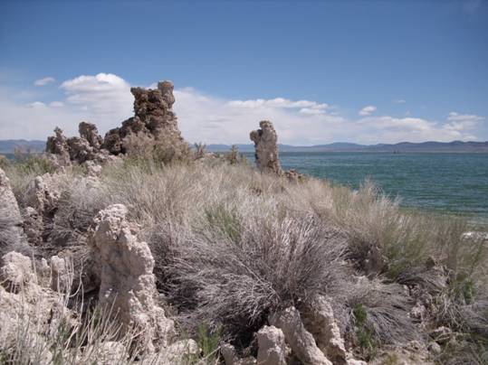
South Tufa Area, Mono Lake, CA
May 2010
Abstract
Mono Lake is a terminal lake located on the eastern side of the Sierra Nevada Mountains. It occupies part of the down-dropped Mono Basin. Faulting and volcanic activity have been important in shaping the basin and Mono Lake. The lake is fed by surface runoff and groundwater whose source is mainly precipitation in the Sierra Nevada. Over its long lifetime, the volume and character of the lake have changed significantly because of changes in climate. However, recent stream diversions made by the Los Angeles Department of Water and Power rapidly changed the lake levels by cutting the inflow of water to the lake, a process from which the lake is currently recovering.
Introduction
Mono Lake is located in Mono Basin, part of the Great Basin, an area of the western U.S. where water does not drain into an ocean [Mono Lake Committee website, 2010]. Mono Basin is east of San Francisco, on the eastern edge of the Sierra Nevada range. This drainage basin is defined by the Bodie Hills to the north, Cowtrack Mountain to the east, Long Valley to the south, and the Sierra Nevada range to the west [Bursik and Sieh, 1989]. The total area of the basin has been estimated at 634mi2 to 801mi2 [“Mono Ecosystem,” 1987]. The larger figure includes an area of Nevada with groundwater that might be joined with the basin [Vorster, 1985].
Mono Lake is a terminal lake which means that like the Great Basin, the lake has no outflow to the ocean [Williams, 1996]. Therefore, evaporation is the major output with streams and precipitation that falls directly on the lake as the inputs [Williams, 1996]. In the Mono Basin, the inputs and outputs of the lake are influenced by the surrounding landscape, climatic conditions, and human water use.
Observations
Formation of Mono Basin
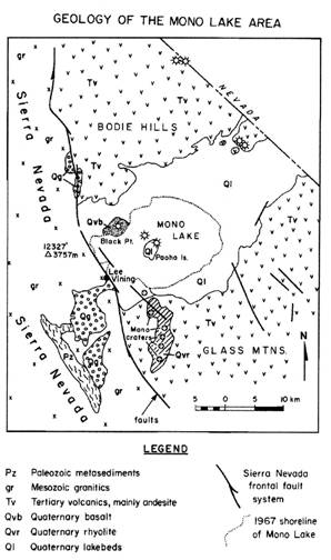
Although located in an area that has been volcanically active, Mono Basin was not formed by a volcanic eruption like Long Valley to the southeast. According to Gilbert et al. [1968], there is only enough volcanic rock surrounding the basin to fill one-quarter of the basin, showing that it was not created by a volcano. Instead, Mono Basin was formed by movement along faults and down-warping. The formation of Mono Basin began three to four million years ago [Gilbert et al., 1968]. According to Huber [1981] in Bursik and Sieh [1989], the area that is now Long Valley and Mono Basin began down-dropping on the eastern edge of the Sierra Nevada. This occurred along the dip-slip faults which are found on the Sierra frontal fault system (Figure 1) [Gilbert et al., 1968]. The vertical displacement between the edges and center of the basin has occurred at a rate of 2 to 4 feet (0.6 to 1.2m) every thousand years [Gilbert et. al., 1968]. Down-dropping continued so that now the bedrock of the basin is 3,353m below the peaks of the Sierras [Hill, 1996].
Gilbert et al. [1968] say that Mono Lake is located on a graben that tilts north. They claim that warping, and not faulting, has caused the difference in elevation between the basin floor and the north, east, and south edges of the basin. There was a lake on the east side of present-day Mono Basin 3 to 4 million years ago, but evidence that it held freshwater indicates that Mono Basin was not yet a closed basin [Gilbert et al., 1968].
Origin of Mono Lake
Sediment has subsequently accumulated in the basin, yet the down-dropping has lowered the basin enough to create a significant height difference from the surrounding mountain ranges. This lower area provided a place for water to accumulate and led to the creation of a lake. Hill [1996] writes that Mono Lake dates to before the Long Valley eruption. The Mono Lake Committee website [2010] explains that ash from the Long Valley eruption was found under lake sediment, with more lake sediment below, helping to date the lake to over 760,000 years old, making it one of North America’s longest lasting lakes. Currently, Mono Lake is about 21 km long and 13 km wide [Hill, 1996]. However, the size of the lake has fluctuated overtime.
In the Pleistocene, the lake was much larger than today and is referred to as Lake Russell. Gale [1914] and others as referenced in Newton [1994] have concluded that Mono Basin has not always been a closed basin in the time it held Lake Russell. According to them, Lake Russell was part of a series of lakes along the Owens River whose watershed included Death Valley. Lajoie [1968], also referenced by Newton [1994], claims that Lake Russell would drain into the Owens River system when the lake reached 2,176m. The lake probably reached its highest levels 12,000 to 14,000 years ago during the Great Ice Age, measuring 45 km by 29 km, making it 120m higher than today [Hill, 1996]. Lajoie [1968] as referenced by Newton [1994] found the lake reached high levels 22,000 and 13,000 years ago. Hill explains that one would expect the lake to have been the largest when the ice started to melt after reaching its peak, yet the high lake volume at the end of the Great Ice Age may be a result of high precipitation that persisted through warming temperatures. According to Newton [1994], who used cores of lake bottom sediment to study the history of Mono Lake, the lake then dropped 800m over a 2,000 year period, resembling more closely present-day Mono Lake.
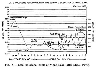
Even over the last 3,500 years, the lake level has varied by 40m [Williams, 1996]. High and low stands of the lake during this time are shown in Figure 2. Williams explains that changes in lake level are caused by changes in climate which would be expected to have a significant impact on terminal lakes. The outflows of non-terminal lakes, like stream flows, will generally decrease when lake levels are lower, but terminal lakes do not have outputs to balance the change in inputs [Williams, 1996]. Williams says that dryer periods cause the volume of the lake to decrease while cooler, wetter periods increase the volume of a terminal lake. This pattern can be seen in Mono Lake, as the lake was largest during the Ice Age.
Volcanism
Mono basin has clear evidence of volcanic activity, and Mono Lake itself contains two visible volcanic islands. The Mono Craters are located south of the lake in a north-south chain and are thought to have begun erupting 40,000 years ago [Bursik and Sieh, 1989]. Negit and Paoha Islands are much younger, both less than 2,000 years old [Bursik and Sieh, 1989]. Negit Island is a cinder cone which first erupted about 1,600 years ago [Hill, 1996]. Paoha Island rose above the surface only 250 years ago but did not erupt completely like Negit. The island is lighter in color because of the lake sediment that was brought upward [Hill, 1996]. However, Hill writes that cinder cones and lava flows can be seen at the north and south ends of the island and have caused the lake level to rise 1.5 to 2.5m. According to Stine [1987], as referenced by Bursik and Sieh [1989], two dikes formed Paoha Island while three are responsible for the formation of Negit Island. The dikes are different from those responsible for the Mono Crater Chain which have multiple vents [Bursik and Sieh, 1989]. In fact, Bursik and Sieh say that the dikes that formed the islands run perpendicular to the Mono chain. The dike intrusions occurred in the last 40,000 years as faulting at the edge of the Sierran range slowed [Bursik and Sieh, 1989]. Bursik and Sieh claim that the dikes relieve strain caused by extensional forces acting on the area.Lake Chemistry
A changing lake level causes changes in salinity. Mono Lake is highly saline because dissolved salts are brought into the lake by rain water and tributaries but are left behind when water evaporates [Williams, 1996]. Blevins et al. [1987], as referenced by Newton [1994], say that the high concentration of salt is primarily from Lake Russell and left over from evaporation. Salinity would have increased as the lake level lowered. Salts would have also collected in Mono Lake in the 10,000 years after Lake Russell receded [Newton, 1994].Mono Lake is also highly alkaline. The pH of the lake is close to 10 [Mono Lake Committee website, 2010]. Newton [1994] explains that water that flows into the lake from the Sierras has eroded the granite, making the water high in sodium carbonates. However, he also says, referencing Bailey [1980] and Shearman et al. [1989], the alkalinity may be explained by CO22- coming up from underground “via the deep structures of extensional tectonics,” similar to East Africa.
Life at the Lake
Mono lake supports a unique ecosystem. Although no fish live in the lake, brine shrimp (Artemia monica) are prevalent and feed on algae. The brine shrimp are an important food source for several bird species. Eared grebes (Podiceps nigricollis) and California gulls (Larus californicus) are the shrimp’s major predators [“Mono Ecosystem,” 1987]. The lake also is home to a species of brine fly (Ephydra hians) which is eaten by birds including phalaropes, grebes, and gulls. Over 80 species of birds either use Mono Lake as a nesting place or stop there during migration [Mono Lake Committee, 2010].Inputs:
Precipitation
Because Mono Basin is a terminal basin, the outputs are limited and are relatively constant, making the inputs the primary controls on lake levels. Most of the water that flows into the basin is from precipitation that falls in the Sierra Nevada range [Vorster, 1985]. This precipitation is mainly due to evaporation over the Pacific which creates eastward moving storms [“Mono Ecosystem,” 1987]. Rain and snow falls over the Sierra when the clouds rise over the mountains. The Sierra Nevada on the western edge of the basin typically receive 50 inches of precipitation per year while only 6 inches falls on the eastern side of the basin [Vorster, 1985]. Runoff from the Sierra Nevada is responsible for 75-85% of water flowing into Mono Basin which is about 150,000 acre-ft per year [“Mono Ecosystem,” 1987].Runoff
There are five main creeks which feed Mono Lake and originate in the Sierra Nevada (Fig. 3). Of the five creeks, Rush Creek and Lee Vining Creek are the two largest. Rush Creek’s watershed starts at Mt. Lyell which stands at over 13,000 ft. Rush Creek carries 45% of runoff, or 59,200 acre-ft of water per year. Walker and Parker Creeks flow into Rush Creek before it reaches the lake. Walker Creek, which begins at Mt. Gibbs (12,800 ft.), carries just 4% of runoff, or 5,400 acre-ft of water annually. Parker Creek has lower flows as well. Its watershed begins at the 13,000ft Kuna peak and transports 5,400 acre-ft of water, about 6% of runoff. Lee Vining Creek, north of Rush Creek, is responsible for 33% of runoff, or 48,000 acre-ft of water yearly. Its watershed includes Mt. Dana at 13,053 ft as well as meltwater from small glaciers. Mill Creek is located towards the north end of the lake. It flows through Lundy Canyon, bringing 14% of runoff. Besides these five creeks, Mono Lake also receives about 35,000 acre-ft of water from other sources. These sources include springs and runoff from the Bodie Hills, Horse Creek, Bohler Creek, and Post Office Creek [“Mono Basin Creeks,” 2010].Groundwater
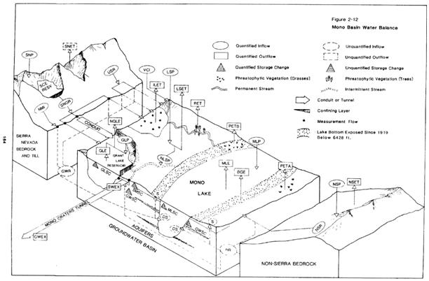
Surface runoff contributes significantly to Mono Lake, but because Mono Basin is a closed basin, groundwater (“GW” in Fig. 4) is mostly contained in the basin. Groundwater movement in the basin is affected by the glacial, stream, lake, and volcanic deposits that fill the
basin [Vorster 1985]. Vorster explains that volcanic and stream deposits act as aquifers because water moves through them easily while the lake sediments left behind from the lake’s high levels in the Pleistocene are impermeable. The water table is less than 50m deep and is closer to the surface near the edges of the lake [Lee, 1969 as referenced by “Mono Ecosystem,” 1987]. Similar to runoff in the basin which gravity takes to the lake, groundwater also travels towards Mono Lake.
Underwater springs feed Mono Lake. Evidence of the springs can be seen in the tufa towers which protrude from the water and dot the shores of the lake. According to the Mono Lake Committee website [2010], the tufa towers form because the water from the springs is high in calcium. The lake contains dissolved carbonates which react with the calcium from the springs. This process creates calcium carbonate pillars, the tufa towers, originating from the lakebed.
Evaporation
Vorster [1985] showed that evaporation estimates for Mono Lake’s surface vary widely in separate studies. He determines the average to be about 46 in. per year, while an LADWP study cited by the Mono Basin Ecosystem report [1987] puts the evaporation rate at 42 in. per year. Although not quantified in Figure 4, Vorster shows evaporation (“E”) and precipitation (“P”) throughout Mono Basin, as well as the location of the aquifers.
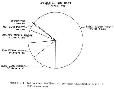
Recent Changes in Mono Lake
In 1940, the Department of Public Works, Division of Water Resources granted the Los Angeles Department of Water and Power (LADWP) permits to divert water from Walker, Parker, Rush and Lee Vining Creeks [SWRCB, 1994]. As a result, from 1941 to 1982, the lake level dropped 45ft and the surface area decreased 30% [SWRCB, 1994]. As of 1996, the salinity of Mono Lake was 90g per liter, an increase from 48 g per liter in 1941 [Williams, 1996]. Vorster shows the typical inflows and outflows in 1975, a year during the water diversions (Fig. 5). Evaporation accounts for nearly 50% of outflows, but Vorster also includes LADWP’s diversions (“Export”). Although indirect, they account for 40% of the lake’s water loss.Fears were that if the water level continued dropping, the brine shrimp and brine flies would no longer be able to survive the increased salinity [“Mono Ecosystem,” 1987]. This would have serious consequences for the birds that use the lake to feed [“Mono Ecosystem,” 1987]. However, birds were already being affected by the changing landscape of the lake. Negit Island was an important nesting place for California gulls, but low lake levels caused the island to be connected to the mainland. In the spring of 1979, coyotes crossed to Negit Island and disrupted the nesting grounds of 30,000 California gulls [Young, 1981]. After a lawsuit filed by the Mono Lake Committee and the National Audobon Society in 1979, the State Water Resources Control Board mandated that no water could be diverted until the lake reached 6,377ft [1994]. The board’s decision also said that diversions after the lake reached 6,377ft could only occur if the lake was allowed to rise to 6,391 ft in 20 years [SWRCB, 1994]. According to Mono Lake Committee, the lake is currently at 6,382 ft.
Discussion
Geologic and hydrologic studies of Mono Basin and Mono Lake have helped answer questions not only about Mono Lake’s origins but also about how water behaves in a terminal basin. These models have also been used to predict changes for ecosystems because of water diversions that created falling lake levels and rising salinity. Reconstructing the high and low stands of the lake (Fig. 2) shows the very rapid drop in lake level due to water diversions in the last hundred years. Mono Lake is certainly not the end of water use controversies in the dry western U.S. as a growing population puts more strain on natural resources, placing sensitive areas like Mono Lake at risk.Conclusions
Mono Lake is found in a terminal basin which began forming three to four million years ago. The basin eventually became closed, and after high levels which made Lake Russell spill over the edge of the basin, Mono Lake became a terminal lake so that surface runoff and groundwater in the area drained into the lake. Because evaporation is the major output of Mono Lake and no streams act to moderate the lower lake levels, the inputs significantly change the volume of the lake. This has been observed in the Ice Age when climatic changes including increased precipitation caused the lake to reach its highest volume. Although changes in precipitation have affected the amount of runoff from the Sierra Nevada, more recently, diversions of four streams have lowered the lake level to a perceptible degree, causing Mono Basin to be the focus of a legal battle. After the establishment of limits on stream diversions, the lake has begun to rise again.Works Cited
Bursik, Marcus and Kerry Sieh. “Range Front Faulting and Volcanism in the Mono Basin,
Eastern California.” Journal of Geophysical Research 94.B11 (1989): 15,587-609. Web. 1 June 2010.Gilbert, C.M., et al. “Structural and Volcanic History of Mono Basin, California-Nevada.”
Studies in Volcanology: A Memoir in Honor of Howel Williams. Ed. Robert R. Coats,Richard L. Hay, and Charles A. Anderson. Boulder: The Geological Society of America, Inc., 1968. 275-329. Print.
Hill, Mary. Geology of the Sierra Nevada. Berkeley: University of California Press, 1996. Print.
“Mono Basin Creeks: Rush, Parker, Walker, Lee Vining, Mill.” Mono Basin Clearinghouse.
Mono Lake Committee. 2010. Web. 31 May 2010.Mono Basin Ecosystem Study Committee, Board on Environmental Studies and Toxicology,
Commission on Physical Sciences, Mathematics and Resources, National Research Council. The Mono Basin Ecosystem: Effects of Changing Lake Level. Washington, D.C.: National Academy Press, 1987. Web. 2 June 2010.“Mono Lake Basin.” Water Right Decision 1613. State of California Water Control Resources
Board, 1994. Web. 1 June 2010.Mono Lake Committee. monolake.org. 2010. Web. 31 May 2010.
Newton, Mark S. “Holocene Fluctuations of Mono Lake, California: The Sedimentary Record.”
Sedimentology and Geochemistry of Modern and Ancient Saline Lakes 50. (1994): 143-
57. Web. 6 June 2010.Vorster, Peter. “A Water Balance Forecast Model for Mono Lake, California.” Mono Basin
Clearinghouse. Mono Lake Committee.1985. Web. 30 May 2010.Williams, William David. "What future for saline lakes?" Environment 38.9 (1996): 12-20, 38-
9. MasterFILE Premier. EBSCO. Web. 2 June 2010.Young, Gordon. "The Troubled Waters of Mono Lake." National Geographic 160.4 (1981): 504-
19. Web. 2 June 2010.