Geology and Natural Heritage of the Long Valley Caldera
Mono Basin's Prized Possession
Tiffany Proffitt
Abstract
Mono Basin in the Eastern Sierra Nevada is an interesting place for scientists. The creation of the basin was formed when two plates collided long ago with help from present stretching of the west coast. Precipitation flowing to this low-lying area created one of the most influential lakes for the ecology of the area, Mono Lake. The plate tectonics of the region also relate to the volcanism seen in the area at Long Valley Caldera, The Mono-Inyo Craters, and even Paoho and Negit Island. Mono Lake was once Lake Russell that has shrunken significantly due to natural causes such as glaciations but also by humans. The Los Angeles aqueducts put Mono Lake’s ecology in grave danger. Many species survive here beginning with algae and other plants to brine shrimp, migratory birds, and mountain lions. The Native Americans also inhabited this land utilizing the resources Mono Lake has to offer.
Introduction
American humorist Mark Twain refers to Mono Lake as the “Dead Sea of California” in his book Roughing It (1872), but this lake is far from dead. Mono Lake serves as the home to millions of brine shrimp, alkali flies, and migratory birds. This lake has seen its ups and downs with many changes over the years, some caused by the natural cycle of Mother Nature and others by anthropogenic means. A man by the name of David Gaines sparked interest of the Mono Basin region when he and his students published An Ecological Study of Mono Lake, California in 1977. Many viewed this problem only as regional and therefore in 1978 he formed the Mono Lake Committee, which served to protect the damaged ecology of the Mono Basin. They sought to increase interest in the scenic and wildlife along with natural history and preservation of these unique and very important lakes (www.monolake.org).The Beginning
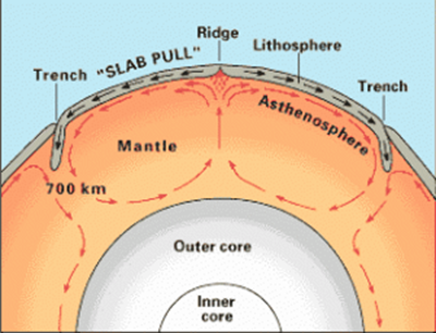
It all begins with the word Pangea. Pangea was the name proposed by Alfred Wegner for the “supercontinent” believed to have once existed. He developed the theory of continental drift to explain the movements of continents. He used fossils, landforms, climate changes, and rock types to support of his theory. Although his evidence supported that the continents had moved, it did not explain how or why they moved. This opened controversy to the theory of continental drift. It was not until the 1960s that the theory of plate tectonics would prove Wegner’s theory was not a joke.The Theory of plate tectonics explains how the continents move. The earth’s interior is made up of layers beginning with the inner core, the outer core, the mantle, and lastly the earth’s crust. The upper mantle is divided into two parts, the lithosphere and the asthenosphere. The presence of the lithosphere and asthenosphere are confirmed by analysis of seismic waves produced during earthquakes. The lithosphere contains the earth’s crust and the upper part of the mantle about 5-30 miles deep (Glasscoe 1998). It sits on top of the asthenopshere, which makes up the lower part of the upper mantle. As one goes deeper into the earth the temperature increases which allows for differing reactions to stress. The lithosphere acts elastically under stress, meaning it is brittle and will break. The hotter and denser asthenosphere acts plastically under stress allowing it to bend and flow. This “flow,” along with gravity, creates a convection current influencing the movement of the rigid but brittle lithospheric plates that sit on top. (See Figure 1).
Figure 1: The layers of the earth with the lithospheric plates that sit on top of the asthenosphere. It depicts the convection current that influences the movement of these plates. (www.usgs.org)Geology of Mono Basin
The Sierra Nevada landscape was formed due to the subduction of the Farallon Plate under the North American Plate. The oceanic crust of the Farallon Plate was of basaltic composition and denser than the granitic composition of the continental crust of the North American Plate. When these two plates began colliding with each other the less buoyant Farallon Plate was pushed under the North American Plate. This caused stretching on the west coast. As the tensional stresses continued they caused a series of fractures in the crust. As the plate continued to stretch, gravity then acted on these fracture lines, creating a series of normal faults that led to the horsts and grabens seen in the region (Hill 2006). The uplifts, or horsts, are also known as ranges and the down drops, or grabens, are also known as basins. This gave name to the Basin and Range Province of the eastern Sierra Nevada.
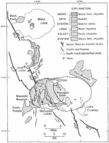
This region acts much differently than what is typical of the eastern United States. Precipitation falls on the high mountain ranges of the Sierra and runs off into the lower lying basins. Since higher lands surround the valleys, the runoff water cannot escape into the ocean like it does in the Appalachians. This is how Mono Lake was formed in the Mono Basin.A chain of volcanic cones sits to the south of Mono Lake. (See Figure 2) This region still exhibits active volcanism with the youngest eruption occurring only 600 years ago. As magma seeped towards the crust it heated underground water turning it into steam. This build up in pressure eventually lead to the eruption that resulted in the Mono-Inyo Craters (www.monolake.org). Cinder and debris from the explosion were blown outward, forming a pumice ring around the vent. Some of these craters, such as Panum Crater, have since been filled in with rhyolitic domes. Excess magma that is high in silica, and therefore extremely viscous, oozes out of the vent. Once the magma hits air it cools very quickly and cannot flow out from the vent but builds on itself creating spires. These spires eventually become top-heavy and crumble, reopening the vent for more magma. The rocks exhibit a glassy texture with little to no crystals proving the magma cooled quickly, not allowing time for crystals to form. These glassy obsidian rocks were used by Native Americans as tools. Another rock typical of rhyolitic domes, pumice, is a light-weight, light-colored rock with holes. It is formed from frothy magma that exploded, trapping air bubbles into the rock as it cooled quickly (www.summitpost.org). Sometimes the two types mix together creating flow rocks. These are rocks with swirls of alternating bands of pumice and obsidian.
To the south of this volcanic dome chain is the Long Valley Caldera. (See Figure 2) Its eruption is dated 760,000 years ago but was on a much larger scale than the eruptions of the Mono-Inyo Craters. Pyroclastic material of hot ash was released forming the Bishop Tuff when it settled. The magma chamber, that contained high- silica rhyolitic magma, was virtually emptied during the eruption, causing the area to collapse, and releasing a secondary eruption (www.lvo.wr.usgs.gov). The ash released during the second eruption created a pyroclastic flow over the previous pyroclatic fall material. A resurgent dome has developed in the depression caused by movement in the magma chamber.
Figure 2: Geological Landforms of Mono Basin. It begins in the north with Black Point, moving south through Negit and Paoha Islands, down through the Mono and Inyo Craters, finishing at the Long Valley Caldera or the resurgent dome. (www.usgs.gov)Sometimes considered the northernmost Mono Crater, Negit Island, sits in the waters of Mono Lake. This volcanic dome was formed from three lava flows. It is darker in color and more rugged than Paoha Island which sits next to it. (See Figure 2) The name Negit means “Blue Winged Goose” and Paoha means “Spirit of the Mist (Russel 1910).” Paoha Island is lighter in color, bigger in size and composed of basaltic lapilli. The island exhibits layers, allowing one to conduce stratification of ancient lake sediments. The hot springs, along with the craters and lava flows in the north and east, suggest active volcanism (Russel 1910). Uplift from the active magma chamber swelling is the cause these of these ancient lake sediments exposure.
Ancient History
Mono Lake is the remnants of a much larger lake that once occupied the region called Lake Russell. It was named after a man who mapped the region in 1881, Israel C. Russell. Evidence from fish fossils which were discovered led scientists to believe this lake was fresh water with an outlet to the north. About 13,000 years ago the lake reached its highest point during the Great Ice Age (Guyton 1998).The first piece of evidence is along the slopes of the moraines, where the town of Lee Vining stands. One can see remnants of the ancient shoreline ingrained in the embarkments well above the present water level. Secondly, it can be interpreted that the glaciers remained a strong influence in the region. ‘V’ shaped canyons are created when creeks cut through land. However, we do not see evidence of this in the Lee Vining Canyon. Instead, we see ‘U’ shaped valleys which are typical of glacial influence. Lastly, we look for evidence at Black Point. Around the same time as the glaciation an underwater volcano erupted. The lava cooled quickly and cracks formed in a north-south direction of the cinder cone. These cracks are called the Black Point Fissures and allow scientists to study Mono Lake. Layers of lake sediment were discovered underneath the Bishop Tuff layer, meaning the ancient lake is older than 760,000 years. In addition, the top of Black Point is flat, meaning it was once located underwater and the water level has fallen significantly (Topinka 2008).
Damaging Effects of the Los Angeles Aqueduct
As Lake Russell began to shrink, there was no outlet for the fresh water. Now, what water remains in Mono Lake typically has a pH between 9-10. This is due to the high alkalinity of the lake. Since the water does not runoff into the ocean, the only means of escape is through evaporation. As the water evaporates it leaves behind minerals such as halite, carbonates, and sulfates. This gives the water a slippery feel when one sticks their hands in. These evaporite minerals also explain why the lake is 2-3 times saltier than the ocean. One can actually float with ease in the water of Mono Lake. The carbonates in the water react with calcium from the hot springs common in the area to form what are known as the Tufa towers. (See Figure 4) These are enormous structures of limestone, chemically known as calcium carbonate (CaCO3). The calcium carbonate precipitates in the water creating huge towers and nesting places for gulls that migrate to Mono Lake.In 1941, the City of Los Angeles began diverting water from the Mono Basin to support its wildly growing population. The Los Angeles Department of Water and Power (DWP) did not see the damaging effects their aqueducts posed to the ecology of Mono Lake. As the water level continued to regress the Tufa towers could no longer grow and now stand erect from where they were birthed. This is why many of these huge towers surround the shoreline. In 1981, the Mono Lake Committee sought to protect these already exposed towers. They were successful in lobbying for the Mono Lake Tufa State Reserve (www.monolake.org).
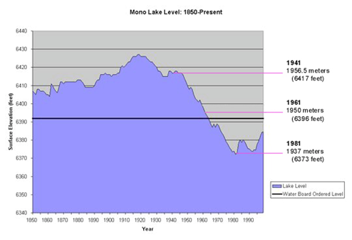
Another damaging consequence to the diversion was the formation of a land bridge to Negit Island. Mono Lake is one of the most successful breeding grounds for the California Sea Gulls that migrate there. This is mostly due to the protection the lake offers from predators. When a land bridge formed, tourists would disturb the nests, as would larger animals preying on the parents, which left nests abandoned. The DWP diverted enough water that by 1982 the lake lost 31% of its 1941 surface area (Reis 2004). (See Figure 3).
Figure 3: Water Level Elevation Changes in Mono Lake. (www.monolake.org)As less and less fresh water from the four tributaries fed into Mono Lake, the alkalinity of the already salty waters increased. A study done by two geologists working for the United States Geological Survey (USGS) reported a drop in brine shrimp during these years following the diversion (Starrett & Perry 1985). The water decrease meant fewer algae for the brine shrimp to eat. Thus, it was survival of the fittest and only some survived. The extremely high salinity also affected reproduction as well as larval growth and development (Starrett & Perry 1985). As the lower levels of the food chain weakened, so did the predators. Migratory birds searched for new places to gather food as well as nest. Less birds meant coyotes and mountain lions must search harder to obtain food. Not only did the diversion harm animals, but it was also dangerous for visitors and tourists. Mono Lake has naturally occurring, inorganic arsenic dissolved in its waters. Most of this arsenic comes from the hot springs found in the region (Oremland et al 2004). As the water level dropped the concentration of arsenic increased. There is not enough fresh water to cover the layer enriched with arsenic, leaving faint hints of the poison in the air for visitors to breathe.
Ecology of Mono Lake
Mono Lake serves as the home to many organisms, beginning with algae. This microscopic, single celled algae form during the winter and early spring months when nutrients are carried in through runoff. The brine shrimp and alkali flies use the algae as a food source. The migratory birds then feed on these little creatures.Alkali flies, Ephydra hians, are unique to Mono Lake. Their life cycle begins underwater, where they are encased for the larval and pupal stage. Once ready to become adults, they disrupt the encasing with an inflating sac and float to the surface. Eventually these flies will return underwater using tiny hairs to trap air bubbles, for breathing underwater, to lay their eggs. In the pupae stage the alkali flies are rich in protein and fat. They are a delicatessen the Kutzadika’a people use in stews as well as for trade with neighbors. These people inhabit the Mono Basin in the summer months, hunting and gathering, much as their ancestors once did. The alkali flies were of such importance to their culture that they named themselves “fly-eaters” or Kutzadika’a in their own language (www.monolake.org).
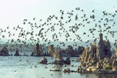
Some of the migratory birds that inhabit Mono Lake are phalaropes, sea gulls, and grebes. (See Figure 4) Wilson’s Phalaropes use Mono Lake as a port of departure. The females arrive first leaving the males to raise the young in the marshy breeding grounds of the northern US and southwestern Canada. Upon arriving to Mono Lake, the phalaropes molt new feathers to prepare for their 3,000 mile journey to South America (www.audubon.org).
As already mentioned, the California Sea Gulls use Mono Lake as a nesting ground during the summer months. Negit Island is the second largest California seagull rookery. The island provides a mating ground as well as protection from unwanted predators.
The most unusual bird seen at Mono Lake is the Eared Grebes. They live entirely on water. Arriving from northern US and southern Canada, they stop at Mono Lake for the summer to feed. Here they more than double their original weight. They are excellent divers, using their long beaks to gather the brine shrimp abundant in the waters. Before leaving they must go through a period of fasting to allow their digestive organs to shrink back to normal size. Once ready to depart they take off from the water leaving only at night (www.monolake.org).
Figure 4: Migratory Birds flying into Mono Lake to nest and eat during the summer months. The Tufa Towers shown are a safe place to build these nests. (www.monolake.org)Mono Lake is also home to other smaller animals such as chipmunks, kangaroo rats, and jackrabbits that use the abundant sage brush to protect themselves. The sagebrush is the most dominant plant life seen in this region due to its tolerance in extreme conditions. It survives through both extremities of temperature as well as harsh sunlight and drought. The native Paiutes that once inhabited the area used the leaves in tea as well as to ward away unpleasant spirits. The pinyon pine scattered around Mono Lake play just as an important role for these small critters. The pinyon pine provides nuts and a good source of protein, fat, and carbohydrates(www.monolake.org).
To the south of Mono Lake is another kind of pine…the Jeffrey Pine trees. These trees favor higher altitudes, producing cones the length of a hand. They grow very large and are widely used for their lumber. Many were cut down when the town of Bodie existed during the gold mining phase but the Inyo National Forest now manages the logging of these fragrant trees (www.monolake.org).
Conclusion
The native Kutzadika’as inhabited this land long before the first settlers. They used the many resources Mono Lake had to offer in order to survive while still preserving its natural state. Slowly as time changed so did Mono Lake. The delicate ecology was disrupted by the gold miners of Aurora and Bodie, the agriculturists that utilize the fresh water, and the booming population of Los Angeles.Mono Lake is a precious antique of the Mono Basin that has a lot of culture and history tucked away under its waters. It gives scientists another piece to the puzzle of how the earth works. Providing a home to a variety of species, Mono Lake has proved itself to be a living lake telling its visitors the story of the western United States.
Work Cited
14 Oct 1999. Geologic History of Long Valley Caldera and the Mono-Inyo Craters
Volcanic Chain, California. USGS: Long Valley Observatory. Retreived 4 June 2009 from <http://lvo.wr.usgs.gov/History.html>2005. Wilson’s Phalarope. National Audubon Society. Retrieved 13 June 2009 from
http://web1.audubon.org/waterbirds/species.php?speciesCode=wilpha&tab=natHistory21 March 2008. Panum Crater. Summit Post. Retrieved 11 June 2009 from <http://www.summitpost.org/view_object.php?object_id=389894>
2009. History of the Mono Lake Committee. Retrieved 5 June 2009 from
<http://www.monolake.org/>Glasscoe, Maggie. 1998. Plate Tectonics. SCIGN Education Module. Retrieved 12 June 2009 from http://scign.jpl.nasa.gov/learn/index.htm
Guyton, Bill. 1998. Glaciers of California. California Natural History Guides, 59. Los Angeles: University of California Press.
Hill, Mary. 2006. Geology of the Sierra Nevada. Los Angeles: University of California
Press.Oremland, Ronald S., John F. Stolz & James T. Hollibaugh. 2004. The Microbial
Arsenic Cycle in Mono Lake, California. FEMS Microbiology Ecology, 48, 15-18.Reis, Greg. 2004. Mono Lake: Coming Back from the Brink? Southwest Hydrology, 20-21.
Russel, Israel Cook. 1910. Volcanoes of North America: A reading lesson for students
of geography and geology. New York: The Macmillan Company.Starrett, G. L., and W. M. Perry. 1985. Multiple generation salinity acclimation
experiment. Report to the Los Angeles Department of Water and Power.Topinka, Lyn. 15 April 2008. Visit a Volcano. USGS: Cascades Volcano Observatory.
Retrieved 15 June 2009 from <http://vulcan.wr.usgs.gov/Volcanoes/LongValley/VisitVolcano/framework.html>