Geology and Natural Heritage of the Long Valley Caldera
Geologic History of Death Valley
Shannon E. Goings
Abstract
The creation of Death Valley in its present state was not begun until the late Tertiary period, most likely during the Miocene epoch. Although Death Valley’s oldest rocks are Pre-Cambrian, other features are extremely young on the geologic time scale and have been created through many different types of geologic processes. This paper details the processes that make up the overall landscape of Death Valley, as well as going into more specific detail about certain features within Death Valley. The features mentioned include Artist’s Drive, evidence for glacial lakes, playa salt deposits, and alluvial fans.
Introduction
The beauty of Death Valley is obvious, but how did it get it’s current beautiful landscape? Humans did not move the mountains to their positions on either side of the valley. what did? This paper serves to answer that question by delving into the creation of the overall landscape, both past and present, as well as specific details in order to help understand what has happened since the valley’s overall formation.
Overall Landscape
I. Precambrian Rock
The area we now call Death Valley has obviously not always been a long valley in between two distinct mountain ranges. This area was, in Pre-Cambrian times, mainly creating rock through sedimentary and metamorphic formation. Although the origins of this rock, now mainly schist with some gneiss, can no longer be identified, by comparing the exposed strata found in the Badwater area of Death Valley with other similar strata, scientists are able to define the time period of the original rocks’ creation, setting it near the end of Precambrian, closer to the beginning of the Cambrian period [Corsetti and Hagadorn, 4].Around the same time period (later Precambrian), geologic evidence points to the creation of rock not only in the Badwater area, but in other parts of Death Valley as well. One major formation is in the Panamint Mountains to the west of Death Valley. Precambrian-age rocks are abundant slightly east of the valley, in many of the canyons, as shown in Figure 1 with Trail Canyon. This Precambrian rock is now visible because of uplift that occurred later during the Miocene era. The most frequently found rock type in this area, like at Badwater, is schist. The highest part of these valleys though, is covered by a layer of dolomitic limestone, with some schist included. Although this limestone does not have any traces of fossils, scientists in the late 1940s agreed that the Precambrian rock was metamorphically altered through time but was originally sedimentary. This has since been proven by dating the Lower Cambrian rocks (which include fossils) that, although they have been uplifted, were originally layered on top of the Precambrian rock [Hopper, 402-403]. The evidence of fossils in the Cambrian rock plus the dolomitic limestone layer of the Precambrian rock leads some geologists to believe that a great body of water covered this area at some point during the Precambrian-Cambrian transition [Corsetti and Hagadorn, 300]. Because of their severe alteration, however, it is very unlikely that these rocks’ history will ever be fully understood [Natural Features and Ecosystems, no pag.].
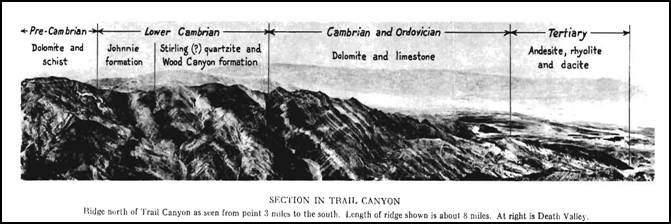
Figure 1[Hopper, 400]Throughout the Precambrian and Cambrian periods, there is possible evidence that ancient volcanoes erupted throughout the area. Although this evidence is widely disputed, some scientists do put forth the claim that the schist found in the Precambrian layers of rock was originally basalt [Fleck, 2807]. There is no current way of proving this theory, since the schist in this area has been altered and changed so much that it would be nearly impossible to tell the difference between metamorphic and igneous schist [ USGS, Death Valley National Park Virtual Geology Field Trip, no pag.]. What is known, however, is that the area we now call Death Valley was, during this time period, the coastal edge of the continent [Natural Features and Ecosystems, no pag.].
II. Cambrian Formations
Although the oldest rocks in Death Valley are of Precambrian origins does not mean that all of the rocks are Precambrian. Many other rocks were formed later and layered on top of the Precambrian formations. Early Cambrian-age rocks can be found layered on top of the Precambrian rocks. Unlike the Precambrian rocks, these rocks are much easier to read and give us a much clearer picture of what might have happened millions of years ago.In the Panamint Mountains, to the west of Death Valley, a definitive contrast between the Precambrian rocks and the Cambrian outcroppings in visible. Unlike the other sections of rock, this section is extremely angular and does not conform to the Precambrian rock that is slightly to the west and below it, therefore making it stand out (see Figure 1). The oldest specimen of Cambrian rock in this area is known as the Johnnie Formation, and can be found not only in canyons like the Trail Canyon in the Panamint Range, but also across the valley in the Black Mountains, as well as other parts of Nevada and Eastern California [Hopper, 403].
In all these locations of the Johnnie Formation, fossils of the same type can be found. These fossils, when dated, are what show that this formation is most likely the link between Precambrian and Cambrian times [Corsetti and Hagadorn, 301]. Although again, it is hard to tell what the history of these particular rocks are, due to their age, the fossils found in them are marine, which means that it is very likely the area was covered with water during the transition from Precambrian to Cambrian [Sharp, 15].
In the Wood Canyon formation, which is layered on top of the Johnnie formation and found mainly in the Panamint Mountains to the west of Death Valley, the marine fossil evidence is even stronger. Fossils such as olenellid trilobites, Helicoplacoid echinoderms, and brachiopods have all been found within this layer, only adding to the theory that this area was covered with water at this time. This formation too, we can date with much better precision. Since there is an abundance of fossils, these fossils can help give us an idea of the age of the rock. Most scientists agree that the area is early Cambrian because of the type and mix of fossils [Natural Features and Ecosystems, no pag.].
The dolomite and limestone that are layered above the Wood Canyon formation can be found in many areas throughout the Basin and Range province, for example, in Trail Canyon (see Figure 1). Around Death Valley, outcrops of this formation are found throughout the valleys of the Panamint Range, as well as parts of the Black and Funeral Mountains. These layers are, on average, about 9000 feet (~2,743 meters) [Hopper, 407]. By using fossils and other layers that are in similar stratigrafic areas, to date this layer, Dr. Edward Cook identified those fossils in the upper layer as being Ordovician in origin, while the fossils slightly lower than this represent the later Cambrian period [Corsetti and Hagadorn, 301]. Again, all of these fossils are marine in nature, leading scientists to believe that a lake or body of water of some sort covered most, if not all of this area throughout the Cambrian period [Hunt, 4]. This water covering was soon to be disturbed, however, by tectonic processes to the west.III. The Late Paleozoic and Mesozoic Eras
Like the Cambrian period, much can be deduced from the landscape about the Paleozoic and Mesozoic eras. At this time, the Death Valley region changed dramatically. Instead of a quiet, water-covered land near the continent’s edge, volcanoes and mountains formed and subsequently changed the landscape forever. These volcanoes and mountains did not just spring up out of the ground. On a much larger scale than a single valley area, continental plates began shifting creating new land. It was at this time that the Pacific Plate began to slide under the North American plate, forming a deep trench in the Pacific Ocean. The tectonics associated with this subduction caused a chain of volcanoes to form on the continent’s surface. Over 1000 meters of magma erupted from these volcanoes, pushing the coast of the continent farther to the west and creating new land [USGS, America's Volcanic Past: Death Valley, Death Valley National Park, no pag.]. This subsequently moved the Death Valley region more inland, making it possible, with the later addition of more mountain ranges, for the rain-shadow effect to create the current grueling and hot climate that makes the valley so distinct.Eventually, the magma chambers that were feeding the volcanoes cooled down and began to form granite. Through thrust-faulting, these large granite outcrops are very prevalent in the high Sierra Nevada mountain region, although a few are also in the Panamint Range that borders Death Valley. During this time, Death Valley was not a valley between mountain ranges like it is today. Instead, evidence points to the theory that Death Valley was instead a large, mountainous region created by the tectonic forces at work. Any sediment from this now non-existent mountainous area flowed downwards and to the east and west, leading to mineral deposits in the areas directly to the east and west at the base of the Panamint and Black Mountain ranges. Although these deposits were quite small, especially when compared to the large fields west of the Sierra Nevada, gold was mined in Death Valley and later, with much greater success, borax. Precious metals have also been added to the area by granitic plutons, in particular, a small one that emplaced about 67-87 million years ago [USGS, America's Volcanic Past: Death Valley, Death Valley National Park, no pag.].
After the major volcanism and thrust-faulting that took place during the tumultuous Paleozoic and Mesozoic eras, the Cenozoic era was a relatively quiet time of inactivity. This inactivity lasted approximately 42 million years until it was shattered by more major changes to the landscape during the Miocene epoch.IV. The Miocene Epoch and the Making of the Modern Landscape
The Miocene epoch has been credited with the creation of the Death Valley landscape that we see today. Although that is not entirely accurate, since many things since then have shaped it, the basic and overall landscape is still much as it probably was at the close of the Miocene epoch [Natural Features and Ecosystems, no pag.]. During this time, crustal extension changed the landscape drastically, causing volcanism to again start up in the region and creating what we now know as the Basin and Range province, including the valley portion of the Death Valley area [USGS, America's Volcanic Past: Death Valley, Death Valley National Park, no pag.]. Within Death Valley, during the Miocene epoch, volcanoes erupted, covering the valley and the surrounding area with volcanic ash, as is the case with Artist’s Drive. After the Miocene epoch, other things continued to change the landscape. Large evidence shows possible ice age lakes that would have covered the entire valley during the Pleistocene epoch, enormous amounts of salt playa sediment have collected within the valley, and large spreads of sediment flow down from the mountains on either side, creating alluvial fans. [USGS, Death Valley National Park Virtual Geology Field Trip., no pag.].Artist’s Drive: Miocene Ash Deposits and Hydrothermal Alteration
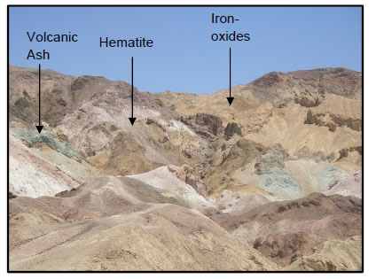
The area known as Artist’s Drive today is a beautiful array of greens, yellows, and reds that look sprayed across the surface of the rock. The rock there is made up of gravel, playa deposits, and a large amount of volcanic ash and debris left from volcanic eruptions during the Miocene epoch and before [USGS, Death Valley National Park Virtual Geology Field Trip, no pag.]. These layers are about 5,000 ft (1524 m) thick [Natural Features and Ecosystems, no pag.]. Hydrothermal alteration or alteration due to intensely heated water passing through rocks and changing their composition, as well as chemical weathering, give the picturesque view of the many colors as Artist’s Drive. As shown in Figure 2, brick reds and pink are the result of iron-rich hematite while the gold and yellow result from different iron-oxides. The green portions are chemically altered volcanic ash [USGS, Death Valley National Park Virtual Geology Field Trip, no pag.].
Figure 2 [Recreated by Shannon E. Goings using USGS, Death Valley National Park Virtual Geology Field Trip, no pag.]Lake Manly and Ancient Lake-Bed Evidence
Later, during the Pleistocene epoch, ice ages cooled the earth’s climate in this area and created a much wetter area. The area known as Shoreline Butte shows evidence of a large lake, known as Lake Manly, which filled Death Valley. This butte would have stuck up above the water as an island in a lake that was nearly 100 miles (approx. 161 kilometers) across and almost 600 feet deep (approx. 183 meters). Lake Manly, as demonstrated by the map below, would have covered the entirety of the valley area, including Furnace Creek.
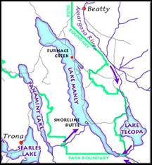
Figure 3[ Natural Features and Ecosystems, no pag.]
Shoreline Butte has multiple horizontal lines on its side. These lines resemble strandlines, or lines that are etched into stone when waves batter repeatedly against its surface. Since it take time for waves to erode rock in this manner, the lines provide a timeline of stable heights for the lake. Although strandlines are visible in other parts of Death Valley, those as Shoreline Butte are the most obvious, as shown in Figure 4 [USGS, Death Valley National Park Virtual Geology Field Trip, no pag.].
Figure 4 [USGS, Death Valley National Park Virtual Geology Field Trip, no pag.]Another piece of evidence that shows that Lake Manly most likely existed is the almost 8,000 feet (approx. 2500 meters) of sediment that overlay the valley floor. These layers bear a distinct resemblence to other lake-bed sediments and deposits. Since Lake Manly, several other lakes have occupied Death Valley, but these lakes were very small in comparison. The most recent of these was in 2005, when flooding due to heavy rain created a lake spanning the majority of the valley floor. This lake though, unlike Lake Manly, was extremely shallow, reaching only about 2-3 (~1 meter) feet in depth [Valkenberg, no pag.].
Salt Playa
One of the most famous areas of Death Valley is the salt flats. These areas of ground are the remnants of the lakes, such as Lake Manly, that once covered the valley floor. Earlier in the Holocene epoch, the climate was wetter than it is today. Lakes filled the valley up to about 30 feet in height (~10 meters). These smaller versions of Lake Manly eventually dried up as the climate grew warmer and the rainfall dropped. Visible from points higher off the valley floor such as Dante’s View, these salts have crystallized on the surface and expand and contract with the heat, as is obvious with Devil’s Golf Course. When the now infrequent rains come to the valley, these expanses of salt liquefy and mix with the water, creating briny mixes along the valley floor. These mixes of water and salt are short-lived though, since the water quickly evaporates and the salt begins to create crystals once more [USGS, Death Valley National Park Virtual Geology Field Trip, no pag.].Alluvial Fans
As heavy rainfall and flooding occurs, creating minor lakes and melting away the beautiful salt crystals, water rushes through the deep canyons on either side of the valley. As these flash floods speed their way through the canyons, they carry silt and debris with them. When the water reaches the valley though, the steep sides of the canyon fall away, giving the water plenty of room to spread out. Because it spreads out, the velocity of the water drops and it is no longer able to carry the sediment. Instead, the sediment falls to the ground and creates deposits that fan out of the mouths of canyons along both the Panamint Range and the Black Mountains [USGS, Death Valley National Park Virtual Geology Field Trip, no pag.].
Although many of the fans against the Black Mountains are obvious, half-moon shapes that spread down into the valley, the alluvial fans against the Panamint Range overlap each other tremendously, making it difficult to tell one fan from the next. The difference is the number of canyons that cut into the mountains. The canyons in the Panamint Range are very near to each other, therefore allowing the fans of sediment to overlap once they reach the valley. Also, because of this, the fans are higher on this side of the valley, at times going as far as halfway up the mountainside [USGS, Death Valley National Park Virtual Geology Field Trip, no pag.].
Figure 5: The alluvial fans of the Panamint Range as seen from Dante’s View. Note the overlap and height of the fans in comparison to the mountains.
[USGS, Death Valley National Park Virtual Geology Field Trip, no pag.]These alluvial fans are created ever time water rushes down into the valley, as long as the mountains have existed. Many times, though, the fans are covered by newer fans and incorporated into the valley floor (See Figure 6). Radiocarbon dating puts the oldest visible fan at 5,000 years old, but this is simply those that can still be seen and measured [Hooke, 2076]. Many alluvial fans were probably covered and spread out by the multiple bodies of water that have covered the area, moving the sediment from it’s original resting place.
Figure 6: The lighter colored gray circular shape is the active alluvial fan, while older fans have most certainly been darkened by the desert and incorporated into the valley floor.
[USGS, Death Valley National Park Virtual Geology Field Trip, no pag.]Conclusion
From alluvial fans to Precambrian rock strata, Death Valley is a wealth of geologic information. It not only gives us its own history, in the form of strandlines that show possible ancient lakeshores and beautiful chemically altered rocks that come in many colors, but it gives us a glimpse at the entire history of this area, including the creation of volcanoes and the Basin and Range. The landscape of Death Valley has taken tens of millions of years to create and continues to change with time.Works Cited
Corsetti, Frank A. and James W. Hagadorn. "Precambrian-Cambrian transition: Death Valley, United States." Geology 28.4 (2000): 299-302.
Fleck, R. J. "Age and Tectonic Significance of Volcanic Rocks, Death Valley Area, California." Geological Society of America Bulletin 81 (1970): 2807-2816.
Hooke, Roger LeB. "Geomorphic Evidence for Late-Wisconsin and Holocene Tectonic Deformation, Death Valley, California." Geological Society of America Bulletin 83 (1972): 2073-2098.
Hopper, Richard. "Geologic Sections of Death Valley." Bulletin of the Geological Society of America (1947): 393-432.
Hunt, Charles B. Death Valley: Geology, ecology, and archaeology. Berkeley: University of California Press, 1976.
Miller, Martin G. Geology of Death Valley National Park : land forms, crustal extension, geologic history . Dubuque: Kendall/Hunt, 2002.
Natural Features and Ecosystems. 20 February 2009. National Park Service. 4 June 2009 <http://www.nps.gov/deva/naturescience/naturalfeaturesandecosystems.htm>.
Sharp, Robert P. Geology Underfoot in Death Valley and Owens Valley. Missoula: Mountain Press Publishing Company, 1997.
USGS. America's Volcanic Past: Death Valley, Death Valley National Park. 27 January 2003. 5 June 2009 <http://vulcan.wr.usgs.gov/LivingWith/VolcanicPast/Places/volcanic_past_death_valley.html>.
Death Valley National Park Virtual Geology Field Trip. 2004. 10 June 2009 <http://geomaps.wr.usgs.gov/parks/deva/devaft.html>.
Valkenberg, Alan Van. Discussion about 2005 flooding and lake Shannon Goings. 17 May 2009.