Geology and Natural Heritage of the Long Valley Caldera
An Unquenchable Thirst: The Relationship Between Water and Owens Valley
Liz Fraccaro
Abstract
This paper intends to highlight the formation of Owens Valley, beginning in deep time and tracing the geological processes to modern times. Once in the twentieth century, the usage of freshwater in Owens Valley, its eventual path to Los Angeles and the resulting environmental impact is explored.
Introduction
Owens Valley, a part of the Basin and Range Province stretching across California and Nevada, is a land brimming with geological and political history. The valley formed at the same time as the Sierra Nevada and can be considered an enormous fault block. Filled with granitic sediments containing both quartz and feldspar, water further eroded and shaped the valley over thousands of years. Snowmelt streamed from the sides of the Sierra and the Inyo Mountains, eventually converging to form Owens River. Owens River fed Owens Lake, which formed in the deepest point in the valley. This rich fresh water resource was greedily eyed by the city of Los Angeles, almost 200 miles away. Over eight years, a gravity-led aqueduct was built under the guidance of then-mayor Fred Eaton and the engineer William Mulholland. Steadily robbing Owens River of the majority of its water, Owens Lake and the surrounding agriculture dried up into a terrible dust bowl. Today, the city of Los Angeles is working in partnership with the Owens Lake Committee to slowly restore Owens Lake into the important natural resource it once was for countless unique flora and fauna, while also anchoring the dusty lake sediments and clearing the air.
Formation of Owens Valley
Owens Valley is essentially an enormous fault block, with the Sierra Nevada to the West and the White and Inyo Mountains to the East. This fault-bound basin sometimes referred to as a “Graben” (Darla Heil, Overview of Owens Valley) was created by divergent forces within the North American Plate. In this case, the land that now forms Oregon and California was moving in a westward direction, in the opposite direction of the rest of the North American plate. Forces similar to this, aided by the subduction of the Farralon plate, formed the Basin and Range Province.
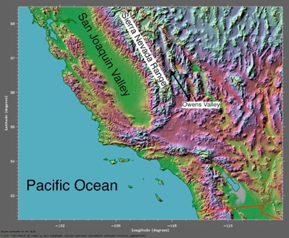
As seen in this altitude reflecting solar image, Owens Valley sits far below the peaks of the surrounding mountains.The Owens Valley fault is difficult to date. The region’s bedrock consists of granitic rock containing quartz and feldspar. This rock was created by the eruption of magma chambers 80 to 120 million years ago (Darla Heil, Overview of Owens Valley). This rock was further exposed two to five million years ago, which corresponds with other eruptions and earthquakes in the area caused by the subduction of the Farralon plate. However, this is not the immediate rock that you or I can walk on today. The mountains on either side of Owens Valley are also composed of granitic rock, which is easily eroded. Snowmelt and some limited rain aided and expedited the erosion process. As water trickled, poured, or otherwise drained into the valley, it carried sediments with it. In addition, glacial wear and tear during the most recent ice age also carried its share of sediments into the valley below. Great alluvial fans formed, which today create the Owens Valley floor, rising thousands of feet above the original bedrock valley floor.
Earthquakes
Earthquakes have played an incredibly influential role in Owens Valley’s unique geography and geology. One of the largest earthquakes in Owens Valley in recorded history occurred on March 26, 1872 (Darla Heil, Overview of Owens Valley). Called the Lone Pine Earthquake, it reached an estimated magnitude of eight on the Richter scale (Darla Heil, Overview of Owens Valley). The ground surface break that occurred as a result of this earthquake can be seen today as a fifteen to twenty foot high scarp on the eastern side of Crater Mountain. Important information can be gleaned from this simple scarp, including the fact that this was not a single-motion earthquake (separating east-west or north-south, for example), but rather several movements in one moment. In addition to the generally east-west motion that had already scarred the valley, the Sierra Nevada moved northward as well, creating a tri-directional pull on the crust.Formation and History of Owens River and Owens Lake
Following the last ice age, an enormous freshwater glacial lake formed in Owens Valley. The modern Owens Lake was a remnant of this glacial lake, fed by the freshwater Owens River. Like many other lakes in the basin and range province, Owens Lake was a terminal lake, meaning it never drained or fed into the ocean. All water that fed into Owens Lake stayed in Owens Lake- that is, until it evaporated or humans came along. Much of Owens Lake had evaporated by the twentieth century, leaving it increasingly high in saline and increasingly similar to the fantastically unique ecosystem that formed in Mono Lake. Being a saline lake, people did not go directly to Owens Lake to retrieve their water, and instead diverted freshwater from Owens River and other mountain streams fed by snowmelt.
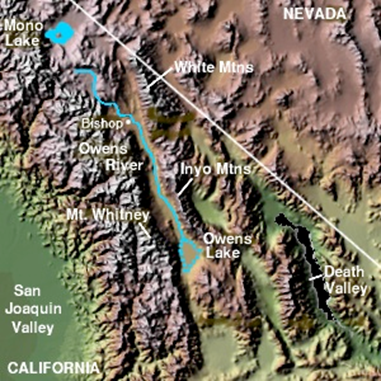
In this figure, one can see the original path of Owens River and the location of the now dried Owens Lake.Beginning in the 1800s, people began to divert freshwater from entering Owens Lake, and used it for agricultural purposes. In 1913 the Los Angeles aqueduct was completed, and this was the metaphorical nail in the coffin for Owens Lake. By 1924, Lake Owen was a playa, or dried lakebed. The formation of the Owens Lake playa had significant environmental impact. Owens Lake was once a significant rest stop for migrating birds of the western United States, and once dry, these birds were displaced. The drying of Owens Lake significantly changed the landscape and the air of Owens Valley. As the lake dried, the lakebed sediments were released into the air. More than just sand, the lakebed sediments also contained arsenic, sulfates, and nickel (Darla Heil, Overview of Owens Valley). Owens Valley essentially became a steep-sided dust bowl with a fan blowing over the top, stirring up a toxic poison. Loosened by wind and severely polluting the air, the sediments made farming and living in the valley difficult. By the late 1990s and early 2000s, Los Angeles and local authorities came to an agreement that requires the city of Los Angeles to control the dust from the lakebed and meet federal air quality standards by 2010 (Overview of Owens Valley).
History of Water Usage: Fred Eaton
Fred Eaton was elected mayor of the city of Los Angeles in 1898 (“Fred Eaton.” New Perspectives on the West). A selfish and self-made man, Eaton taught himself engineering and was a mastermind of real estate, making him a formidable enemy for Owens Valley. In the same year of his election, Eaton created the Los Angeles Department of Water and Power. Placing William Mulholland in charge, Eaton began the enormous undertaking of creating the Los Angeles aqueduct. Powered by gravity, the aqueduct was sure to work- Eaton’s largest challenged was acquiring the rights to the water in Owens River and the rights to the land the aqueduct would run through. First, Eaton had to convince Washington that agriculture would be more profitable if the water from Owens River were diverted to locations along the way to Los Angeles, such as what became the Haiwee Reservoir.
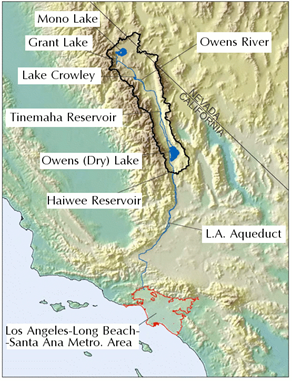
In this image, one can trace the path of the Los Angeles aqueduct from its starting point in the Owens River to Los Angeles. Making the image larger is recommended.Eaton’s next moves were truly corrupt. Eaton began purchasing land and water rights throughout Owens Valley, but bought key properties for himself with the plan to sell his land to the city of Los Angeles when they finally began the project of building the aqueduct. This self-serving action ultimately was Eaton’s downfall. When the time came for the city of Los Angeles to build a reservoir for the enormous amount of water it had now taken from Owens River, they had to purchase the land from Eaton. Eaton’s asking price was one million dollars (“Fred Eaton.” New Perspectives on the West). William Mulholland, the engineer of the aqueduct, and the city of Los Angeles refused. As a result, the city had to further re-direct the aqueduct and Owens River, and they had to choose a new location for the dam and reservoir (“Fred Eaton.” New Perspectives on the West).
History of Water Usage: William Mulholland
William Mulholland, engineer of the Los Angeles aqueduct, was no less selfish than Fred Eaton. Similarly self-made, Mulholland also taught himself engineering through his humble beginnings as a sewer cleaner in Los Angeles. By 1905, Mulholland was in charge of the building of the Los Angeles aqueduct, and he completed the project by 1913 (“William Mulholland.” New Perspectives on the West). While Mulholland faced his share of challenges from Fred Eaton, his greatest challenge by far was the opposition from the residents of Owens Valley. In 1924 the resident farmers, infuriated by the loss of water from their irrigation systems, used dynamite to destroy the aqueduct. On November 16, 1924, the farmers banded together again and seized control of an aqueduct gate and stopped the flow of the river in an armed protest. However, the most dramatic and damning event in the war over the aqueduct occurred on March 12, 1928. Angered by Fred Eaton’s ridiculous asking price of one million dollars for a parcel of land, Mulholland was forced to hastily build the St. Francis Dam and reservoir on a different piece of land. On March 12, 1928, the St. Francis Dam collapsed and flooded an enormous area. The breaking of the dam released fifteen billion gallons of water. As the water forced a seventy-mile long and two-mile wide path to the sea, it flooded and destroyed the majority of Ventura County. (“William Mulholland.” New Perspectives on the West). Leaving almost five hundred people dead, Mulholland became a disgraced engineer and public enemy and was forced to resign later that year.Current State of Water Usage
Until the 1990s, the Owens Lake Playa, air pollution, and water divergence from Owens River had largely been ignored for the two or three decades previous. However, a drought that struck Owens Valley in 1987 and grew stronger over the next three years forced a change in policy. Owens River was running low, and the ever-decreasing Owens Lake (aka Owens Puddle) was creating more intensified dust problems. Water conservation programs were implemented across the state of California. These conservation programs are still in effect, although the drought has disappeared. Almost twenty years later, the water usage in areas served by Owens River are averaging 800,000 acre feet of water below the 1990 levels (Stepping Outside the Box: Water in Southern California). This means that more water is available to flow through Owens River, rather than through the aqueduct.
However, this water was not initially diverted back into the river. Active petitioning by locals and The Owens Valley Committee has slowly but surely helped the reformation of a web of Owens Lakes and a higher flow of water through Owens River. In the 1990s, Los Angeles was forced to meet federal clean air standards in Owens Valley, which resulted in the formation of the Los Angeles Owens Lake Dust Control Project.
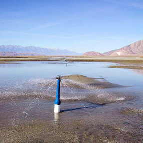
Irrigation bubblers in Owens Lake- a water based dust control method. This is one way of restoring water to the playa and anchoring down loose and dusty lakebed sediments. Photo courtesy of the Great Basin Unified Air Pollution Control District.This project has dedicated one hundred square miles to dust control and restoration of Owens Lake. Thirty square miles of those one hundred square miles are devoted to water-based dust control, such as the bubblers pictures above. Twenty-seven square miles of those one hundred square miles is devoted to pond water and sheet flood, which is essentially the restoration of Owens Lake into the saline and alkaline ecosystem migrating birds flock to. Roughly four square miles of those one hundred square miles is dedicated to native salt grass, which is grown using a drip irrigation system that prevents the formation of sheet flood and provides long-term dust control and a restored habitat for the fauna of the region (Stepping Outside the Box: Water in Southern California).
Conclusion
Owens Valley holds an important place in human and geological history. Studying the interaction of geology, water, and humans is incredibly important. Unfortunately, humans have learned the hard way that water resources are not unlimited and play an important role in the unique flora and fauna of Owens Valley. It is my hope that Owens Valley will serve as a reminder to all politicians that taking advantage of nature is ultimately at the expense of humankind. Owens Valley slowly travels toward an equilibrium between human water needs and the restoration of natural conditions, and will hopefully become a successful story of humans and nature finding harmony.
Works Cited
Broder, John M. “Los Angeles Mayor Seeks To Freeze Valley Growth.” The New York Times. 8 August 2004. 3 June 2009. http://www.nytimes.com/2004/08/08/us/los-angeles-mayor-seeks-to-freeze-valley-growth.html?sec=&spon=&pagewanted=2
“California's Owens Valley - site of the Terrain-Induced Rotor Experiment (T-REX).” Base map from the Color Landform Atlas of the US. 6 June 2009.
http://www.met.utah.edu/whiteman/T_REX/“Fred Eaton.” New Perspectives on the West. 2001. PBS. 3 June 2009. http://www.pbs.org/weta/thewest/people/d_h/eaton.htm
Garrigues, George. “Fred Eaton Back From Owens River: Ex-Mayor Tells of the Plan for
Diverting Part of Its Flow to Los Angeles.” Los Angeles Express. 4 August 1905. 3
June 2009. http://www.ulwaf.com/LA-1900s/05.08.html#EatonHeil, Darla et. all. Owens Valley Overview. 2009. Owens Valley Committee. 3 June 2009. http://www.ovcweb.org/OwensValley/OwensValley.html
Kahn, Carrie. “L.A. Returns Water to Owens Valley.” Morning Edition. 7 December 2006.
National Public Radio. 3 June 2009.
http://www.npr.org/templates/story/story.php?storyId=6590362“Los Angeles Aqueduct Map.” 2007. Hydrology Futures. 16 June 2009.
http://www.hydrologyfutures.com/LAA.html“More irrigation bubblers in the playa.” 19 January 2009. Photo courtesy of the Great Basin Unified Air Pollution Control District.) 6 June 2009.
http://images.google.com/imgres?imgurl=http://farm4.static.flickr.com/3403/3210795143
_67eca637e4_o.jpg&imgrefurl=http://pruned.blogspot.com/2009_01_01_archive.html&u
sg=__SFK016IT6sSNaZPbwrhYfTsFilE=&h=550&w=550&sz=141&hl=en&start=32&u
m=1&tbnid=xyvSRpEc4HplCM:&tbnh=133&tbnw=133&prev=/images%3Fq%3Dowen
s%2Blake%2Bold%2Bshoreline%26ndsp%3D21%26hl%3Den%26sa%3DN%26start%3
D21%26um%3D1Stepping Outside the Box: Water in Southern California. 2009. The Mono Lake Committee. 3 June 2009. http://www.monolake.org/mlc/outsidebox
“William Mulholland.” New Perspectives on the West. 2001. PBS. 3 June 2009.
http://www.pbs.org/weta/thewest/people/i_r/mulholland.htm