Geology and Natural Heritage of the Long Valley Caldera
Nuclear Waste at Yucca Mountain, Nevada
Kaitlyn Esther
Abstract
The United States has over 50,000 metric tons of nuclear waste located across the country [Rogers and Kingsley, 2007]. This review will discuss the proposed repository at Yucca Mountain. The issues include understanding what nuclear waste is, and the area of Yucca Mountain itself. Yucca Mountain, although arid, has water enough to possibly bring danger to the site. There is also seismic, tectonic, and volcanic activity throughout the entire Basin and Range which is where Yucca Mountain is located. This review will also touch on how the Department of Energy has decided to combat these issues through engineering barriers. Scientists are being forced to use geology, a science of the past, to create a prediction of 10,000 years in the future.
Introduction
Since the creation of the atomic bomb in the mid 1940s, nuclear power has become a source of mass energy consumption. Although the use of nuclear power, nuclear energy, and nuclear power plants is continuously a subject of heated debate, the difficulty of storing the leftover nuclear waste from these projects is what requires the most attention to date. After the Nuclear Waste Policy Act of 1982, it is up to the leaders of society to find a suitable holding location for nuclear waste. Yucca Mountain, Nevada is currently the only site still under consideration.
There are roughly 125 reactor sites in over 39 states that temporarily hold nuclear waste. This translates to over half of the population living within miles of a nuclear waste site. This waste has been created through commercial use, military building of weapons or equipment, medical and many other industries’ nuclear consumption. In order to combat the issues the rising level of nuclear waste creates, scientists and politicians are looking into a long term repository. This review will discuss the definition of waste and whether the area of Yucca Mountain is safe for nuclear waste to be permanently stored at that location.Waste
Nuclear waste is derived from an abundance of sources but is generally separated into two categories. The first category, nuclear fuel-cycle waste, is the type most commonly referred to when discussing waste storage at Yucca Mountain. Nuclear fuel-cycle waste is the waste that occurs when creating nuclear fuel through the processing of uranium and when using nuclear reactors to produce plutonium for nuclear weapons, to generate electricity for commercial and residential use, and to produce radioisotopes for the medical, industrial, and commercial fields.
Fuel-cycle waste itself is divided into two categories: high-level and low-level radioactivity. High-level radioactive waste is created when nuclear fuel is reprocessed to remove plutonium. The plutonium is then used in the building of nuclear weapons. Although the United States outsources the chemical processing of the nuclear fuel to other countries, the plutonium and high-level radioactive waste is returned for use and disposal respectively.
Low-level radioactive waste is the term used for any nuclear fuel-cycle waste that is not high-level. The term is misleading at times since the level of radioactivity of this waste can be as hazardous as the high-level waste. Low-level waste is generally created in nuclear facilities, when radioactively contaminated sites are cleaned, and when reactor-produced radioisotopes are used in fields such as medicine and industry.The second category of nuclear waste is any waste occurring naturally or created in accelerators. This waste is commonly referred to as NARM: Naturally-occurring or Accelerator-produced Radioactive Material. Naturally-occurring radioactive materials usually come in the form of potassium-40, uranium, thorium, and radium. These are typically produced when radionuclides are removed from drinking water sources, when ash is used in the generation of electricity, when fertilizer is produced, and when ores or minerals are processed and used in industry. Accelerator-produced materials, materials derived from a machine that uses sub-atomic particles to separate electrons from their nucleus, are typically radioisotopes that are developed and used in medicine.
Characteristics of Area
Tectonics, Seismicity and Volcanism. Fifteen million years ago large volcanic eruptions southwardly deposited volcanic rock, forming what is today Yucca Mountain. Seven million years have lapsed since the last of these eruptions has occurred; causing scientists to agree that the site is safe from a possible future large scale eruption. Small volume volcanic activity is what is actually causing the most concern around the area. Small scoria cones, ranging in scale from slight to heavy erosion, found in the Crater Flat basin west of Yucca Mountain are proof of this volcanic activity. Basaltic eruptions have formed these scoria cones and are estimated to have occurred anywhere from 0.1-3.7 million years ago. [Ewing and Macfarlane, 2006]
Yucca Mountain was once apart of this volcanic activity, until it was uplifted now forming a mountain range. Currently the Basin and Range is being tectonically extended, forcing the land to diverge in a north to south linear way. Due to this record of eruptions, and tectonic uplift, some scientists predict further eruptions to occur farther from Yucca Mountain and closer to the valley.
Climate. Yucca Mountain has an arid climate, averaging 7.5 inches of rainfall annually. In the regulatory 10,000 year period it is expected to rise to 12.5 inches of rainfall each year. This is not a drastic change, yet even so almost 95 percent of that precipitation is either caught in runoff through vegetation or directly evaporated. [U.S. DOE Website, 2009] This severely limits the amount of water that would be able to seep into the underground repository.
Geology. The volcanic rock forming Yucca Mountain is a stratification of welded and nonwelded tuff. The welded tuff is found at the surface and at the level of the repository, while the nonwelded tuff frames both the top and bottom of the repository. The nonwelded units contain few fractures, hindering the process of water infiltrating farther into the ground. The little water that is able to reach the repository level will be contained within small fractures of the welded tuff. These have a tendency of remaining within the fractures rather than flowing directly into large areas such as the tunnels.
http://pubs.usgs.gov/circ/circ1293/images/Figure1_large.jpg
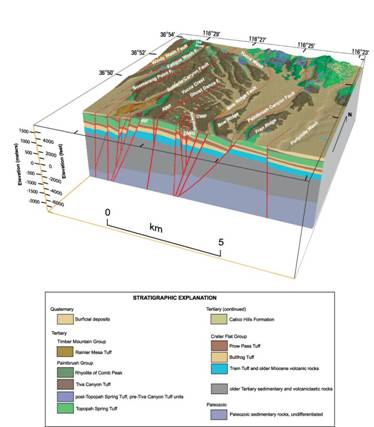
Hydrology. The hydrology of Yucca Mountain has been studied by many groups, specifically the United States Geological Survey, the Berkeley National Laboratory, and the Los Alamos National Laboratory, since it was determined to be a potential site for the storage of radioactive waste. Although the Yucca Mountain hydrological study area contains approximately 60,000 km2, the area of study for the above-mentioned groups covers an area of approximately 40 km2. Data is derived using boreholes and trenches at the land’s surface, field observations and studies, and a 12-km long underground tunnel. The water table in the study area is, on average, 510 m below the land surface and is discharged into the Death Valley region. Paleozoic carbonate rock aquifers compartmentalize and drain the groundwater flow which predominately moves north to south from the study region to the drainage area.
The most important environmental factor regarding waste storage is the net amount of precipitation infiltration that would occur at the Yucca Mountain site. The winter months see the most infiltration at the site due to a larger amount of water during this time of the year. This increase in water is due to snowmelt, lower evaporation rates, and an abundance of snow in the higher altitude regions during this season.
The second most important environmental factor to net infiltration is soil depth. The larger the soil depth, the more conductive the hydrological flow. The shallower the soil depth, the more potential there is for accumulations of water below the soil surface that do not discharge from the area and could potentially cause harm to the waste storage facility. The soil depth at Yucca Mountain is a little less than 3 meters which allows for enough water flow for the accumulation of water not to be a hindrance to the storage facility.
ENGINEERING STRUCTURES
www.ymp.gov
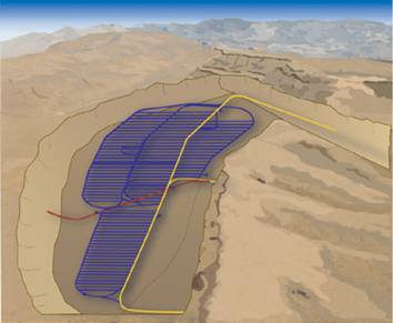
The storage facility at Yucca Mountain was started in 1994. The main aspect of the facility is a five-mile-long tunnel that slopes into the mountain face, turns south for three miles and then slopes back up to the surface. It was constructed using a twenty-five-foot-diameter, football-field-and-a-half-long tunnel boring machine (TBM). The TBM was created specifically for the Yucca Mountain project and works by gripping the tunnel walls to push its cutter head into the rock and utilizes conveyor belts to transport the cut rock to the surface for disposal. The tunnel serves as the main access point to the waste repository and as housing for laboratories for studies that will continually be conducted at the facility.
All along the tunnel, small alcoves have been cut into the rock to serve as laboratories. The first alcove, located close to the mountain surface, will be used to study how rain and melted snow move through the rock fractures. These studies help scientists ensure that groundwater drains away from the storage facility. The second alcove contains several boreholes designed by geologists to help map fractures and geologic features to see how gases and fluids move through the area. The third and fourth alcoves were drilled into non-welded tuff, a soft rock, to see how gases and fluids move though this different type of geology. The fifth alcove, drilled at the depth of the repository, was designed to test the effects of heat inside the tunnel. The sixth and seventh alcoves were drilled along Ghost Dance Fault, a major fault near the repository area, to see whether the fault aided or hindered the flow of groundwater toward the repository. Studies have shown that the fault provides a pathway away for the storage site.
A second TBM was used to create a second tunnel at the depth of the repository cutting crossways along the first tunnel. This second tunnel stretches 1.7 miles and is called the cross drift. This second tunnel will allow scientists to continue studying the geology of the mountain close to where the radioactive waste will be stored. An eighth alcove was cut from the second tunnel and gives geologists a larger area to study the same water seepage and flow through the rock.
www.ymp.gov
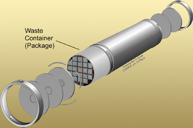
The waste will be contained within a titanium drip shield and a waste container, which have been designed by the Department of Energy to work with the natural landscape of the mountain. The outer barrier will be constructed of Alloy-22, and will be resistant to corrosion at a rate of 0.03 inches in the span of 10,000 years. The titanium is also resistant to corrosion at a rate of 0.08 inches over the same time span. The overall waste package is expected to retain 99 percent integrity over 80,000 years. [U.S. DOE Website, 2009] This would insure the nuclear waste to be safe for eight times the regulated rate.The repository itself has yet to be built. The Department of Energy must provide extensive geological findings to the Nuclear Regulatory Commission before approval will be granted to begin cutting this section of the mountain. When complete, the storage facility will start approximately 600 feet below the land surface and will contain many smaller tunnels branching at a downward slope from the main tunnel to approximately 950 feet. Each smaller tunnel will house waste storage rooms of special corrosion-resistant containers containing fuel rods and/or solidified waste lined end to end along its length.
Possible Hazards of Site
Seismic. The Basin and Range province is home to Yucca Mountain. This region is being expanded along fault lines in a north to south direction which are caused by seismic activity throughout the area. On June 29, 1992 an earthquake occurred twelve miles from the possible repository site measuring on the Richter scale 5.6, and officially becoming the largest seismic activity calculated near Yucca Mountain. The principal concern earthquakes create for the repository is the possibility of structural damage to the facilities. Scientists are attempting to avoid faults that have any chance of displacement, and are currently assessing earthquake hazards through the Probabilistic Seismic Hazard Assessment (PSHA).
There are three stages to this testing which beginnings with the location and identification of problematic active fault lines. Once discovered these faults are then measured for their average occurrence rate as well as the magnitude. The last stage is in estimating the amount of movement the earth will experience. Although this completes the PSHA, many scientists have begun to study precarious rocks around the area’s surface that could also be displaced and possibly cause damage in the event of seismic activity. These rocks, and other rock fractures, could possibly create new avenues for water flow as well. [Macfarlane and Ewing, 2006]
Volcanic. In the case of a volcanic eruption near the repository there are many problems that might ensue. Basaltic flows could mix into repository drips, or even magma could divert into a repository tunnel and cause future eruptions. Some scientists have voiced concerns of dykes of magma forming within the repository or geothermal fluid combining with the nuclear waste. The DOE has completed research detailing the effect of volcanic activity to be minimal upon the area. They have attempted to curb even this apparently small threat through engineering; however, many have wondered whether the design is realistic enough to replicate.
Hydrologic. Although the current data found at the Yucca Mountain study area shows that hydrological contamination of a proposed radioactive waste storage facility is highly improbable, there is not enough information to make firm conclusions. The Yucca Mountain area has only been studied for the past two decades, and the understanding of future hydrological infiltration is still evolving. However, site tests and computer modeling are helping researchers understand future adjustments in climate and hydrology, and the most widely accepted views of the region are that it would not be affected by water infiltration and would tolerate the storage of radioactive waste with little to no harm to the water table and surrounding environment.
Drawn Conclusions
This review has tried to describe the area of Yucca Mountain and highlight a few of the hazards as well as the security the site offers. Although many scientists have been working on predicting the future the site will see with nuclear waste, too many things are yet unknown and questionable. After gathering information from many reputable sources, I support Yucca Mountain as a nuclear waste repository for the United States. There are possible hazards to the site hydrologically, volcanically, seismologically, and militarily. However, any nuclear waste site will encounter such difficulties, and Yucca Mountain has already cleared many hurdles. The world will change over a 10,000 year period, and how can we possibly predict with 100 percent accuracy the safety this sight will insure for future generations? All we now know is that leaving the waste in storage facilities designed for short term use is not a solution. The faster we plan a course of action, the safer we will be. Yucca Mountain should be the preliminary sight, and the possibility of storage elsewhere should only be considered if another, better site is found in the future.
As of June, 2009 the Obama administration has rejected Yucca Mountain as a potential site for radioactive waste storage. Congress has been asked to reconsider other possible sites across the western landscape, and begin geologically studying new areas. Although the change is understandable, one can only assume that any new site would have similar issues to Yucca Mountain. Hopefully this can be resolved quickly and either a new site can be chosen or Yucca Mountain can again be under consideration because the longer waste is stored in current facilities, the larger the chance of catastrophic incidents occurring.
Works Cited
Bodvarsson, Gudmunder S., Fabryka-Martin, June M., Flint, Alan L., Flint, Lorraine E., and Kwicklis, Edward M. “Hydrology of Yucca Mountain.” Reviews of Geophysics 39.4 (2001): 447-470
Department of Energy. “Why Yucca Mountain?” http://www.ocrwm.doe.gov/uploads/files/brochure.pdf, 2009
Ewing, Rodney C., and Long, Jane C.S. “Yucca Mountain: Earth-Science Issues at a Geological Repository for High-Level Nuclear Waste.” Annual Rev. Earth Planet Science 32: 363-401 (2004).
Ewing, Rodney C., and Macfarlane, Allison M. Uncertainty Underground: Yucca Mountain and the Nation’s High-Level Nuclear Waste.Cambridge: MIT Press, 2006.
Kingsley, Marvin G., and Rogers, Kenneth A. Calculated Risks: Highly Radioactive Waste and Homeland Security. Burlington: Ashgate Publishing, 2007.
Kocher, David C. “Nuclear Waste.” http://www.healthline.com/galecontent/nuclear-waste, 1993.
Office of Civilian Radioactive Waste Management. “Yucca Mountain Repository.”http://www.OCRWM.doe.gov/, 2009.