Geology and Natural Heritage of the Long Valley Caldera
Long Valley Caldera: Assessing the hazards of a supervolcano
that may be dusting itself off
Nathan Bower-Bir
Abstract
The Long Valley and Mono Lake area has had a long history of volcanic activity, with a recent period of unrest beginning in 1978. The seismic and magmatic activity that has continued over the past three decades initially caused alarm among many who thought that it was indicative that eruptions were soon-to-come. The caldera hasn’t erupted yet and even seems to be in a quiet period; however, much progress has been made in the area of monitoring this and other volcanoes. This improves the ability of scientists to study these volcanoes and to help authorities and communities to make informed decisions about the potential volcanic dangers. An important part of volcanic hazard mitigation is establishing a plan to follow in times of danger, and in 2002 the Long Valley area adopted such a plan. While it is unknown what kind of eruption will occur, if any, the Long Valley region is making strides towards protecting its people.
Introduction
Shaped throughout its history by numerous and intense earthquakes, glaciers, and volcanoes, the Long Valley Caldera has faced intermittent periods of high activity and relative quiescence. Until thirty years ago, the region was inactive. However, beginning in 1978 and continuing through today, Long Valley has once again become home to high intensity seismic activity together with increased magmatic activity.
The resurgence of activity was cause for alarm. Long Valley was the sight of one of the most explosive volcanic eruptions ever known, and another eruption like that would be devastating. The new activity was successful in inciting within the geologic community interest as well as concern for the threat of potential renewed volcanism. A new drive to monitor and understand the processes of this unique area led both to the installation of new instrumentation in the region and to a wealth of new research and knowledge of the region. This new collaborative knowledge about not only Long Valley, but about volcanoes around the word has already helped save people and their possessions. Such is the goal of volcanic hazard mitigation.
Historical Background
The Long Valley and Mono Lake area has been home to significant volcanic activity since about 3-4 million years ago (Ma) [Bailey et al., 1976; Sorey et al., 2000]. Located in east-central California along the eastern edge of the Sierra Nevada (see Figure 1), the region has experienced intermittent periods of volcanism and relative quiescence. Initial volcanism included widely scattered basaltic and andesitic eruptions, with rhyodacitic eruptions in areas to the west and north following at 3.0-2.7 Ma and rhyolitic volcanism beginning about 1.9 Ma [USGS Long Valley Observatory website, 2007; Bailey et al., 1976].Approximately 760,000 years ago, 600 cubic km of magma was ejected from the chamber beneath Long Valley in a series of eruptions, blanketing the surrounding landscape in the ash flows that formed the Bishop tuff (see Figure 1 for present-day geologic map), and sending airborne dust and ash as far as away Nebraska [Hill, 1997; Bailey et al., 1976]. With the magma chamber evacuated, the roof above collapsed to form a 17 km by 32 km depression ranging 2-3 km deep – the Long Valley Caldera [Bailey et al., 1976]. Rhyolitic eruptions continued in the caldera for the next 100 ka, while a resurgent dome uplifted 500 m from the cauldron floor until about 600 ka [Bailey et al., 1976].
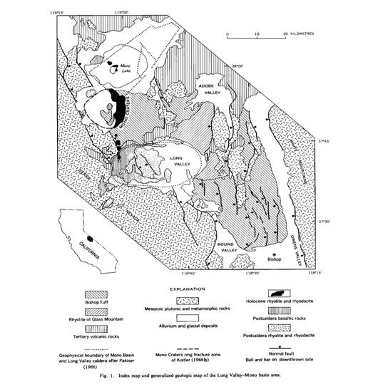
Figure 1. Geologic map of the Long Valley and Mono Lake area. Reproduced from Bailey et al. [1976].The caldera exhibits extensive evidence of significant and intense past hydrothermal activity. Acidic hydrothermal alteration yielded agrillized tuffaceous lacustrine sediments on the resurgent dome as well as large kaolin deposits [Bailey et al., 1976]. Fossil gas vents and sinters have been found in the caldera as well, largely along faults.
Adjacent to Long Valley Caldera, the Mono-Inyo Craters volcanic chain runs north about 40 km, from Mammoth Mountain at the caldera’s southwest to Mono Lake (see Figure 1). Activity in this chain started as long ago as 400 ka, and the chain is the site of the region’s most recent eruptions, dating from the Holocene period. The formation of Mammoth Mountain by several eruptions ended about 50 ka, and every few hundred years throughout the past 4,000 the chain has had small eruptions [Hill et al., 1997; Sorey et al., 2000]. Volcanic and related activity in this chain has been diverse, including explosive eruptions, phreatic explosions, pyroclastic flows, lava flows, lava dome extrusions, lahars, and regional fissure eruptions [Siebert and Simkin, 2009]. It is believed that many of these styles of volcanism were represented in activity as recent as 600 years ago, which yielded several of the domes (Deadman Creek, Obsidian, Glass Creek) and phreatic craters of the Inyo Craters as well as Panum Crater in the Mono chain [Siebert and Simkin, 2009]. However, much is yet to be determined about the specific processes that led to this activity. For example, Matsin [1991] proposes three possible causes for the phreatic explosions of 600 years ago that created North and South Inyo Craters and Summit Crater, one involving the rapid heating of groundwater by rising magma, and another involving the slow heating of groundwater over a period of months to years. Mono Lake is the site of the most recent volcanism in the area, with much of Paoha Island formed just 100-230 years ago when an intrusion of rhyolitic magma uplifted lakebed sediments [Siebert and Simkin, 2009].
The Long Valley area has been subjected to Basin and Range strain, as well as shear strain from the Eastern California Shear Zone. Crustal extension and northwestward normal faulting (see Figure 1) characteristic of the Basin and Range and have been observed in and around the caldera, and it is probable that these have contributed to the seismic and volcanic activity in the region [Martini and Silver, 2002].
Recent Activity – Trouble Brewing?
The Long Valley and Mono Lake area has been a focus of recent attention due to a three-decades-old period of ongoing geologic unrest. Activity began on 4 October 1978 when a magnitude 5.8 earthquake struck just 20 km southeast of the caldera [Hill, 1984]. Swarms of earthquakes followed, gradually migrating toward the caldera. Over the three-day period 25-27 May 1980, four magnitude 6 earthquakes rocked the caldera’s southern margin and the area immediately to the south, leading the U.S. Geological Survey (USGS) to reexamine Long Valley [Hill, 1984; Hill et al., 1997]. Earthquake swarms continued, and studies showed that the resurgent dome had uplifted 20 cm between mid-1979 and mid-1980 – previously, uplift had not occurred in the time since leveling measurements were first taken in the region in 1905 [Hill 1984]. Earthquakes and uplift persisted, with periods of high activity during 1980-1983, 1989-1990, and mid- and late-1997 [Newman et al., 2000]. While the most active period was the initial phase (1979-1980), the 1997 deformation rates were an order of magnitude higher than the rates from the previous three years, and this period of deformation (as well as others) was associated with subsequent, higher magnitude earthquake swarms [Newman et al., 2000; Hill et al., 2003]. As of January 2009, cumulative uplift stood at about 75 cm [Tizzani et al., 2009].There have been many other signs of potential magmatic/volcanic activity in the Long Valley region since 1978. In January 1982, evidence of new fumaroles in the caldera was found [Hill, 1984]. Beginning in 1989, seismic activity beneath Mammoth Mountain increased, including long-period (LP) and even very-long period (VLP) earthquakes deep beneath the mountain [Sorey et al., 2003]. After these earthquakes, large areas of dead and dying trees were discovered on the mountain (see Figure 2), and this was eventually attributed to high levels (20-95% of gas content, as compared to the typical ≤ 1%) of carbon dioxide (CO2) in the soil [Sorey et al., 2000]. Believed to be released from beneath the mountain, CO2 at these concentrations was killing the tree root systems. Sorey et al. [2000] suggest that CO2 emission has remained somewhat stable since 1996 at about 300 tons each day after peaking around 1991. The caldera is also home to many steam vents and hot springs.
The caldera seems to have been in a period of relative quiescence since early 1998, with comparably stable gas emission, reduced seismic activity, and minimal dome uplift [Tizzani et al., 2009]. It is unknown if this lull will persist or if activity will again intensify.
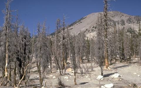
Figure 2. Tree death from CO2 released from Mammoth Mountain. Reproduced from Sorey et al. [2000].Interpretations of Recent Activity & Implications for Residents
What does the post-1978 activity suggest?
Most studies suggest that the intrusion of new magma beneath Long Valley Caldera caused the recent unrest in the area. In fact, Tizzani et al. [2009] identify magma as the “unambiguous” cause; intrusion of basaltic to silicic magma underneath the resurgent dome yielded the dome’s deformation. Sorey et al. [2003] calculate the added volume of magma to be about 0.3 km3. They also attribute seismicity in the caldera to strike-slip motion along faults in the southern part of the resurgent dome as well as south of the caldera in the Sierra Nevada block.Several research teams have concluded that magma has also intruded beneath Mammoth Mountain, perhaps along with gas and water, filling a crack that likely resulted from one or more of the earthquake swarms of 1989. Further, the LP and VLP earthquakes suggest basaltic magma moving beneath the mountain [Foulger et al., 2003; Sorey et al., 2003]. The mountain’s CO2 is exsolving from the intruded magma into a reservoir that extends 3.2 km beneath the surface, from where it is then released [Foulger et al., 2003].
The presence of steam vents and other fumaroles as well as hot springs demands a heat source not too far beneath the surface (see Figure 3). Magma rising near the surface could be heating the water directly or indirectly by heating igneous rocks that contact the water.
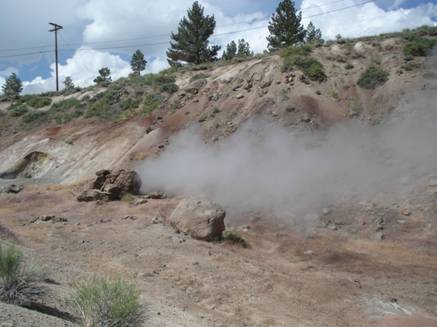
Figure 3. Fumarole activity surrounded by hydrothermally altered rock near Casa Diablo geothermal plant. Source: the author [2009].How could this affect residents?
The future course of magmatism in the Long Valley and Mono Lake area is uncertain. For this very reason, it is important that residents and visitors know the threats from potential volcanic activity.Most researchers expect that future volcanism in the Long Valley area will be similar to that which has occurred there before, and that probabilities of specific events will reflect their frequencies in the past. Hence, people should be aware especially of the hazards posed by the following: explosive eruptions that yield ash falls and pyroclastic flows and surges, as well as the less- or non-explosive lava flows and lava dome extrusions. Further, it should be expected that the likelihood of another lava dome extrusion like those which formed Obsidian and other domes is more substantial than that of a massive event like the one that formed the Bishop tuff; however, the occurrence of such a major eruption would be far more hazardous to a broader region [Miller et al., 1982; Miller, 1989; Rabin, 1997; the following descriptions are adapted predominantly from the first two sources and will not be cited throughout, except where another source is used].
Ash falls, pyroclastic flows, and pyroclastic surges represent the preeminent hazards to human health and safety. Explosive eruptions can launch ash and fragmental debris into the air, resulting in an ash fall. These explosions can vary widely in their intensity and duration – some may last seconds while others continue for hours. Ash falls pose threats to property and human health, especially respiratory systems. Fires ignited by hot pyroclastic debris or lightning (which often accompanies ash clouds) are also of concern. Ash falls are most dangerous at close proximity to the vent; larger debris typically will land within 10 km and ash here will be thickest, while ash and other small particles could be carried by the wind for hundreds of kilometers, although in lesser quantities farther away. Small amounts of Bishop ash from the eruption that created the caldera 760 ka have been found as far east as the middle of Missouri and Nebraska, while Bishop tuff within the caldera boundaries is about 1 km thick [Bailey et al., 1976]. Even in the smaller, phreatic explosions that created the North and South Inyo Craters and Summit Crater, ballistic analysis suggests that fragments were ejected at speeds as high as 100 m/s [Matsin, 1991]. People should stay indoors and breathe through filters or dampened cloths in the event of an ash fall.
Pyroclastic flows present a much greater threat to humans than ash falls. Traveling at speeds up to 150 km/hr, these densely packed masses of debris and gases can be hundreds of degrees Celsius as they flow down towards lower lands, crashing through, burning, or burying all in their paths. However, often due to their significant momenta, the paths of pyroclastic flows cannot always be predicted. Prior to an eruption, people should be evacuated from areas that are likely to see such flows.
Lower in density than pyroclastic flows, pyroclastic surges are fast moving clouds of gas and fragments and can cause abrasion, impact, and damage or destruction to buildings, and can also leave behind ash and fragmental deposits. Because of their tremendous speed (similar to that of pyroclastic flows) and dangerous composition, people should be evacuated prior to an eruption.
Lava flows and domes are substantially less threatening to human life because they move much slower than the previous hazards. Lava flows tend to follow predictable paths, guided by gravity towards lower ground. Viscous silicic flows generally remain within 5 km of their source vent, while basaltic lava may flow for 50 km or more. Fires ignited by flowing lava can pose additional threats. Silicic lava dome extrusions are even slower moving than flows, essentially formed from newly ejected lava pushing up older lava that had piled on the vent, creating a large dome of almost stagnant, cooling rock. However, dome flanks are often unstable during an eruption and can create pyroclastic flows. People should stay at least 5 km away from an erupting dome.
Any volcanic activity where there is snow can cause floods and mudflows, which can sweep up people and even large debris and structures. Due to their predictable paths, however, floods and mudflows can often be avoided by seeking higher ground. Reservoirs like Lake Crowley in Long Valley can help to mitigate the threats posed by floods and mudflows by capturing the flow as it travels downvalley, but only provided there is room enough in the reservoir to contain it.
It should also be recognized that, with about 30% of all the water drawn from the Eastern Sierra by the City of Los Angeles passing through the Long Valley Caldera, an eruption in this region could have significant effects on the L.A. water supply [Rabin, 1997]. As it stands, magmatic and geothermal activity has been adding chemicals like arsenic to the water taken by the city. Were a mudflow to spill into Crowley Lake – the Long Valley Reservoir – the water in L.A.’s largest water storage point for this system would likely be contaminated. Other potential threats include damaging sections of the city’s aqueduct system or the damn at Crowley Lake and altering water courses [Rabin, 1997].
The principal area of recent unrest in Long Valley – the southern section – is considered the most likely site of future eruptions. However, volcanism has occurred along the Mono-Inyo chain within the last few hundred years, and so it would be imprudent to discount the chain as a potential hazard. Unfortunately, any volcanic eruptions in the region could pose threats to the towns of Lee Vining and Mammoth Lakes, which lie along the border of the caldera and could be first to encounter falling ash and debris.
Fortunately, some magmatic activity can be taken advantage of by local populations. Three geothermal power plants operate within the caldera, producing about 40 MW, or enough to power about 40,000 homes [Hill et al., 1997]. The results of magmatism also provide stunning places to visit.
Lessons from Other Volcanoes, and a Plan for Long Valley
Success at Mount Pinatubo
On 15 June 1991, the Philippines faced the second largest volcanic eruption of the century. More than 5 km3 (less that 1/100 the amount that Long Valley ejected 760 ka) of pyroclastic material was ejected in a spectacular eruption that sent ash up 35 km (see Figure 4).
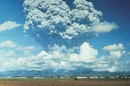
Figure 4. Eruption of Mount Pinatubo, 15 June 1991. Reproduced from Newhall et al. [1998].Pyroclastic flows and lahars raced down the mountain, leaving behind valleys filled with ash, pumice, and other debris, some 200 m thick. A 2.5 km wide caldera formed at the collapse of the summit [Newhall et al., 1998]. Almost 900 people died from the eruption and its effects, and more than 200,000 people were displaced [Ritter, 2006; Newhall et al., 1998]. But the whole story is something of a success. Leading up to the eruptions were several signs of potential activity. These included a massive magnitude 7.8 earthquake in July 1990 centered about 100 km away from the mountain, small earthquakes increasing in frequency beneath Pinatubo that were indicative of rising magma, intense phreatic explosions on the mountainside, and leaking sulfur dioxide. Careful tracking of these events allowed Philippine Institute of Volcanology and Seismology and USGS scientists to predict the eruption and evacuate people and equipment. Their efforts saved more than 5,000 lives and prevented over $250 million in damages [Newhall et al., 1998].
The Rabaul Caldera Eruption – A Hint of Long Valley
After not even a day of intense seismicity, on 19 September 1994 two vents in the Rabaul Caldera in Papua New Guinea began erupting. Thanks in large part to the fact that there was a volcanic response plan already in place, the authorities were able to evacuate 30,000 people from the town that lies within the caldera before the eruptions began [USGS Hawaiian Volcano Observatory website, 1998; USGS, 1994]. Rabaul Caldera is an 8 km by 14 km depression that has geologic similarities to Long Vallery Caldera, and the eruption provided a valuable chance for USGS scientists to learn how future volcanic events in Long Valley might play out [USGS, 1994]. Significant seismic activity and uplift of a resurgent dome threatened the area in the early 1980s, and a stage-2 emergency was declared, preparing people for an eruption. However, earthquakes began to subside, resurgent uplift stopped, and the quiescence persisted until just hours before the 1994 eruptions [USGS Hawaiian Volcano Observatory website, 1998]. Perhaps the quiet period Long Valley has been in since 1998 is a lull before a big show.The Plan for Long Valley
Hill [1984] notes the unfortunate lack of “well-documented case histories of eruptions from these large systems that are supported by data from modern geophysical and geochemical volcano monitoring techniques.” However, by closely observing the activities leading up to, during, and following volcanic eruptions throughout the world, scientists can grasp better common trends or apparent anomalies. Eruptions like that of Mount St. Helens and the aforementioned will offer much needed insight.This is still only half the task. In order for scientists to be able to make use of the data from other volcanoes, Long Valley must be actively monitored for comparison. With tremendous advances in geological monitoring technologies over the past few decades, such monitoring all over the world is becoming routine. While deformation measurements of the resurgent dome had poor temporal resolution until early 1983, with successive measurements separated by months or years, beginning in 1983 scientists installed compact trilateration networks and telemetered tiltmeter networks that would dramatically improve both measurements and interpretability [Hill, 1984]. As another example, eleven dry tilt level figures were installed as part of the USGS initial movement to reevaluate the caldera. With these figures, the kind of rapid deformation that was seen leading up to such eruptions as Mount St. Helens or Kilauea can be repeatedly tracked over short timeframes [Hill, 1984]. Hill [1984] further comments that “continuous, real-time data on short-term changes in ground deformation during a strong earthquake swarm is critical for making informed, on-the-spot judgements regarding the nature of the unrest and the likelihood that it may lead to an eruption.” Data like these will help improve understanding of volcanic regions like Long Valley, and such data is now being gathered.
Good analysis of data is at least as important as the data itself. Techniques and models need constant reevaluation since much of what geologists postulate (e.g. magma chamber size and shape) can rarely be observed directly. Earthquakes are often caused by the movement of plates along boundaries or faults or by the movement of magma beneath the earth’s crust, and it can be difficult to attribute seismic activity to one source or another. For example, the earthquake swarms of 1997 may be attributable to rapid expansion of a dike, frequent slippage along a fault, or buildup of pressure from magma rising to the surface [Newman et al., 2000]. Proper identification of the source of activity can dramatically assist in mitigating the effects of future activity that could result from the same source.
However, it is important to note that modeling can vary greatly between studies. Newman et al. [2000] observe that surface deformation data is not unique and can be made to fit any number of models; modelers should be careful about making rheological assumptions and, when possible, use information beyond the deformation data to constrain the problem. Improvements in computing capacity have proved a boon for geologic modeling, which can now accommodate far more parameters than in the past. Even still, increased computing should not replace careful and creative analysis.
Like the Rabaul Caldera, the Long Valley and Mono Craters region has a volcanic hazards response plan. A central aspect of this plan is a four-color rating system for potential hazards. Each color (green, yellow, orange, and red) represents a given level of activity and identifies appropriate measures to be taken. Condition GREEN identifies periods of “background activity through strong unrest;” Condition YELLOW identifies “intense unrest” and requires, among other measures, increased on-site monitoring of the area; Condition ORANGE identifies a “WARNING” period in which data suggest that an eruption is possible; Condition RED identifies that an eruption (phreatic or magmatic) is in progress (See Figure 5) [Hill, 2002]. These conditions and the procedures that follow from them are integral to coordinated volcanic hazard mitigation like that which occurred in Rabaul Caldera.
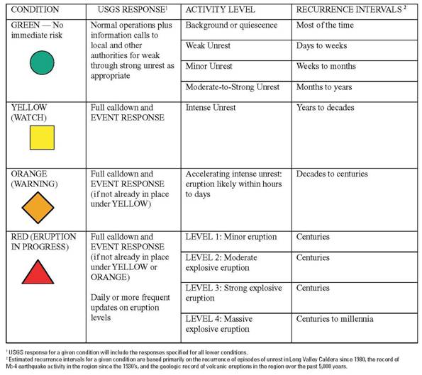
Figure 5. Summary of four color conditions in USGS volcanic hazard assessment plan for Long Valley. Reproduced from Hill et al. [2002].Conclusions
The Long Valley and Mono Lake area has a long history of volcanism, reaching back as far as 4 Ma. The region has had a wide variety of volcanic eruption types, resulting in a diverse and dynamic environment. Recent seismic and magmatic activity has initiated some concern regarding the threat of future volcanic eruptions, especially one as massive as that which created the Bishop tuff 760 ka. While experts agree that such an eruption is possible, it is expected that future eruptions are most likely to mirror the Holocene eruptions that created many of the Mono and Inyo Craters. Regardless of eruption type, hazard mitigation will be successful only if an appropriate action plan is in place and leaders and the local populations are ready to work together to follow the plan. Further, researchers must continue to monitor the region and other sites across the world to further our understanding of the processes that lead to and guide volcanic activity.Works Cited
Bailey, R. A., G. B. Dalrymple, and M. A. Lanphere (1976), “Volcanism, Structure, and Geochronology of Long Valley Caldera, Mono County, California,” J. Geophys. Res., 81(5), 725–744.
Dixon, Timothy H., et al. (1997), “Continuous monitoring of surface deformation at Long Valley Caldera, California, with GPS,” J. Geophys. Res., Vol. 102, No. B6, 12,017-12,034.
Foulger, G. R., et al. (2003), “Three-dimensional crustal structure of Long Valley caldera, California, and evidence for the migration of CO2 under Mammoth Mountain”, J. Geophys. Res., 108(B3), 2147, doi:10.1029/2000JB000041.
Hill, D.P. (1984), “Monitoring Unrest in a Large Silicic Caldera, the Long Valley-Inyo Craters Volcanic Complex in East-Central California,” Bulletin of Volcanology, Vol. 47, No. 2, 371-395.
Hill, David P., et al. (1997), “Living With a Restless Caldera – Long Valley, California,” U.S. Geological Survey Fact Sheet 108-96.
Hill, David P., et al. (2002), “Response Plan for Volcano Hazards in the Long Valley Caldera and Mono Craters Region California,” USGS Bulletin 2185.
Hill, David P., John O. Langbein, and Stephanie Prejean (2003), “Relations between seismicity and deformation during unrest in Long Valley Caldera, California, from 1995 through 1999,” J. volc. geotherm. res., 127, 175-193.
Martini, Brigette A., and Eli A. Silver (2002), “Is Long Valley Caldera Part of the Eastern California Shear Zone? Some Answers from Hyperspectral Imaging,” Geological Society of America Annual Meeting, Ses. No. 224.
Matsin, Larry G. (1991), “The roles of magma and groundwater in the phreatic eruptions at Inyo Craters, Long Valley Caldera, California,” Bulletin of Volcanology, Vol. 53, No. 8, 579-596.
Miller, C. Dan (1989), “Potential Hazards from Future Volcanic Eruptions in California,” U.S. Geological Survey Bulletin 1847, 17p.
Miller, C. Dan, et al. (1982), “Potential Hazards from Future Volcanic Eruptions in the Long Valley – Mono Lake Area, East-Central California and Southwest Nevada – A Preliminary Assessment,” Geological Survey Circular 877.
Newhall, Chris, James W. Hendley II, and Peter H. Stauffer (1998), “The Cataclysmic 1991 Eruption of Mount Pinatubo, Philippines,” USGS Fact Sheet 113-97.
Newman, A.V., et al. (2000), “Geodetic and seismic constraints on recent activity at Long Valley Caldera, California: evidence for viscoelastic rheology,” J. volc. geotherm. res., 105, 183-206.
Rabin, Jeffrey L. (1997), “Water Supply at Risk if Mammoth Erupts,” The Los Angeles Times, 17 Dec.
Ritter, Michael E (2006), “Volcanic Hazards and Episodes,” The Physical Environment: an Introduction to Physical Geography, http://www.uwsp.edu/geo/faculty/ritter/geog101/textbook/title_page.html, Accessed 17 Jun 2009.
Siebert, L. and T. Simkin (2009), “Volcanoes of the World: an Illustrated Catalog of Holocene Volcanoes and their Eruptions,” Smithsonian Institution, Global Volcanism Program Digital Information Series, GVP-3, http://www.volcano.si.edu/world/, Accessed 15 Jun 2009.
Sorey, Michael L., et al. (2000), “Invisible CO2 Gas Killing Trees at Mammoth Mountain, California,” USGS Fact Sheet 172-96, version 2.0.
Sorey, Michael L., Vicki S. McConnell, and Evelyn Roeloff (2003), “Summary of recent research in Long Valley Caldera, California,” J. volc. geotherm. res., 127, 165-173.
Tizzani, Pietro, et al. (2009), “Uplift and magma intrusion at Long Valley caldera from InSAR and gravity measurements,” Geology, v. 37, no. 1, 63-66.
USGS (1994), “USGS Scientists Head for Papua New Guinea to Help During Volcanic Emergency,” Press Release, 26 Sep, http://vulcan.wr.usgs.gov/Vdap/NewsReleases/rabaul_press_release_sept94.html, Accessed 15 Jun 2009.
USGS Hawaiian Volcano Observatory website (1998), http://hvo.wr.usgs.gov/volcanowatch/1994/94_09_23.html, Accessed 16 Jun 2009.
USGS Long Valley Observatory website (2007), U.S. Geological Survey Volcano Hazards Program, http://lvo.wr.usgs.gov/, Accessed 15 Jun 2009.