Geology and Natural Heritage of the Long Valley Caldera
The Geologic History of the Long Valley Caldera and the Landforms Created Within
Nicole Pluchinsky
Abstract
Abstract
The Long Valley caldera eruption was a major explosion which resulted in the destruction of a wide area, along with hundreds of feet of ash, called the Bishop Tuff, being dumped on the immediate area. Though the eruption was catastrophic, activity still continues within the Long Valley area today. The magma chamber that continues to lie beneath the Long Valley caldera heats the water for the Hot Creek springs and has been the cause for the formation of Mammoth Mountain . The growth of Mammoth Mountain and the increase in activity at Hot Creek is a definite indication that the Long Valley is still a threat for an eruption. This lurking hazard serves as the basis for the evacuation plans and warnings for the Long Valley caldera and its surrounding areas. While an eruption cannot be predicted precisely, being ready for an eruption can help to mitigate the danger if one was to occur.
Introduction
California is a state with diverse scenery and formations; millions of years have shaped the landscape into the unique and beautiful areas seen today. Volcanoes played a large part in developing these areas in the western part of the United States , as did the Farallon and North American plates. Throughout the years, much of the activity has slowed or stopped altogether, but, by studying the deposits left behind, the processes involved can still be understood. As James Hutton once said, “It is only through understanding our past that we can really understand our present.” A large portion of the activity in California was found to be in the Long Valley caldera region and its surrounding areas. Not only was there a great deal of activity, but as the events were large scale they can be easily identified and observed. By studying the geologic history, and more specifically the eruption history, of the Long Valley caldera, inferences and predictions can be made about future eruptions and activity within. The history of the caldera can also help in understanding why and how the landforms, like Mammoth Mountain and Hot Creek, were created after the major eruption hundreds of thousands of years ago.
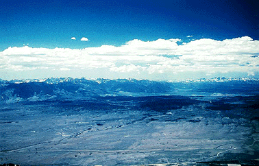
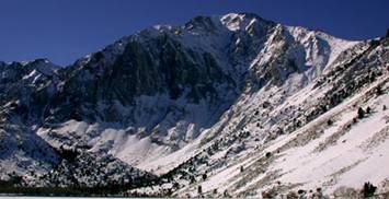
The Long Valley caldera and eastern Sierra Nevada.
Long Valley Caldera
Located near the Sierra Nevada, the Long Valley caldera has a unique and explosive history. A caldera is a feature formed by land collapsing in on itself after a volcanic eruption. The collapse is caused by a magma chamber beneath the land erupting and emptying out. After enough magma erupts out of the chamber, the land cannot support the soil which had previously covered the chamber, causing the soil to collapse. An event similar to this description happened in the Long Valley area.
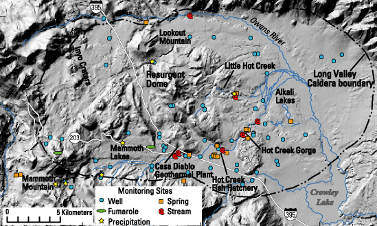
The Long Valley caldera is the largest eruption in recorded history. Oval in shape, the caldera is 15 by 30 km in size. The elevation of the caldera is 2,000 m in the east and 2,600 m in the west (“Long Valley Caldera”). The walls reach an average elevation of 3000-3500 m, except in the east where the wall reaches only 2,300 m (“Long Valley Caldera”). The Long Valley area's size is truly understood only when standing within. From the top of Lookout Mountain , the caldera's reaches become clear; the distance from edge to edge is astounding, especially when it is remembered that the caldera was formed by a volcanic eruption.
Long Valley Eruption
The caldera area started its activity around 3.6 million years ago (“Long Valley Caldera”). The first eruptions consisted mainly of basalt and andesite. After the initial eruptions of basalt and andesite, rhyolite began to erupt in large quantities, from around 2 million years ago to about 800,000 years ago (“Geologic History”). Though there were many eruptions over a span of millions of years, they were miniscule in comparison to the catastrophic eruption which took place 760,000 years ago. Gasses were expelled in each eruption, but the pressure was not reduced enough to prevent the dangerous explosion that took place. The rhyolitic magma rose upward through vents and openings in the ground. Building up as the magma rose, the gas pressure began to increase exponentially. As it reached close to the surface, the pressure was trapped beneath the soil that sat above the magma chamber. Finally, the pressure grew to be too great and the eruption began.
As the volcano erupted, tons of ash came spewing outwards. Ash flew across the caldera and spilled out for miles, traveling hundreds of miles per hour. Hot ash destroyed everything in its past; incinerating vegetation for miles. The temperature of the ash from the explosion has been calculated to about 800º C (Hill 274). The heat was so great that the magma cooled instantaneously, meaning it did not have time to crystallize. Lacking crystallization, the lava cools into glass-like fragments, an example being obsidian. Around 625 cu km of this super-heated ash spread over much of the western half of the United States , even reaching to Nebraska (Hill 274). In some places, the ash fell to be more than 200 m thick and spread out more than 1,500 sq km (Hill 271). Due to the continued eruptions after the main one, the ash first deposited 760,000 years ago cannot be seen within the caldera, as it is buried deep underneath the ash from the post-eruptions. No volcanic eruption in recorded history has reached the magnitude of the Long Valley caldera eruption.
Bishop Tuff
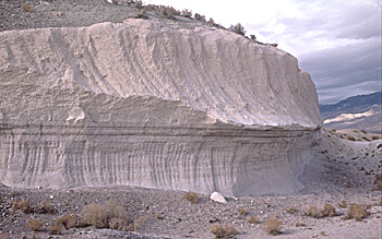
Exposed outcrop of Bishop Tuff in Chalfant Valley 25 km southwest of Long Valley caldera by R.A. Bailey.
The high quantity of ash which fell from the Long Valley eruption 760,000 years ago is now called the Bishop Tuff. While most of the ash fell from the first major eruption, not all of it did; some of the ash fell from many different post-eruptions. At times, the later erupted ash traveled quickly enough to cover earlier layers. This stratified layering effect can be seen when looking at exposed outcrops on the outside of the boundaries of the caldera. Some of the layers contain cobble to boulder-sized rocks within, giving evidence of the powerful pyroclastic clouds which came sweeping out from the different eruptions and covering the immediate surrounding areas with debris and ash. Other layers contain fine-grained rocks, which are incredibly small. These layers indicate that the eruptions from the volcano were not always strong and powerful. All of the layers show beautifully each individual eruption that took place and how strong the eruptions were. The Bishop Tuff is mostly a uniform color, one that is reminiscent of a pinkish-white chalky substance. Pieces of the Bishop Tuff have a somewhat rough texture, with many pieces feeling like fine-grained sandpaper. There are many uses for the pumice, from being used for the rough texture in toothpaste which removes plaque from the teeth to being put into washers to make stonewashed jeans.
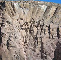
A rosette in the Owens Valley Gorge (www.flickr.com)
While most of the Bishop Tuff has a soft stratified layer effect, the welded tuff can take on another appearance. Welded tuff is formed when the superheated ash falls onto the ground and starts to compact together and solidify; the compacted and heated ash solidifies into a rock-like structure. There are rare occurrences where the welded tuff is put under a lot of pressure, which reheats the tuff and allows it to move and form different shapes. An interesting phenomenon is rosettes, with great examples being found in the Owens Valley Gorge. A rosette is formed when the welded tuff is put under pressure, allowing the rock to bend and reform into these fan-like structures, seen in the picture. The Bishop Tuff has many different looks and textures, though it formed around the same time from the same volcano. These different appearances make the Bishop Tuff a unique landform to study; one which cannot be found elsewhere with its extensive distinct formations.
Hot Creek
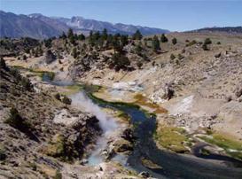
Hot Creek, though a small stretch of area, is an interesting and beautiful sight to see. Steam from the heated water can be seen rising from the springs next to the cold stream water, helping to distinguish the hot water from the cold; the hot springs are also light blue, a stark contrast to the dark blue of the cold stream water running beside them. The springs are an ever-changing system, where unexpected geysers boil up with superheated temperatures; temperatures so hot they can reach hundreds of degrees within seconds. The stream itself was formed by a lake which, after centuries, receded, leaving only a stream cutting through the gorge (“Boiling Water” 2). Melting snow from the mountains flows downward, joining the stream and sustaining the temperature of the stream water at about 10º C (“Boiling Water” 2). Though most of the stream water is cold, there are portions that are actually quite hot, due to the hydrothermal system below Hot Creek. A hydrothermal system is fairly simple in complexity, making it easy to understand what takes place. As the snow melts from the mountains, the water travels underground and heats up as it moves through hot rock heated by cooling magma. The water can reach temperatures up to 220º C but does not boil or turn into a steam, due to the high amount of pressure on the water (“Boiling Water” 2). Since the density of heated water is less than cold water, the heated water rises up towards the surface through fractures and vents. Once the water reaches the depth of 0.5-2 km, it flows eastward to release points at Hot Creek and Crowley Lake (“Boiling Water” 2). The temperature decreases a great deal as it continues east and mixes with the cold meltwater in the Hot Creek stream. The Hot Creek springs fall between two different faults, with a discharge of about 8.5 cu ft of hot water per second; this makes up about 70% of the heated water discharged in the Long Valley caldera area (“Boiling Water” 3).
Recent activity with geysers in Hot Creek has led to some concerns. The hot springs have been closed to visitors, due to the hazards associated with the unpredictable heated geysers. From May 2006, the springs have been producing geysers that are extremely hot and powerful. The definitive reason for these geysers occurring more recently is unknown; however, it is theorized that the hot geysers are a result of an influx of earthquakes in 1997, which created more fractures giving hot water more access into the ground thermal water (“Boiling Water” 3). This theory is supported in that ground activity, such as earthquakes, often allows fractures to open or reopen, creating more avenues for heated water to navigate underground and putting the water closer to the cooling magma. This Hot Creek activity is a prime example that the Long Valley area is still very dangerous.
Mammoth Mountain
Mammoth Mountain
Mammoth Mountain has an exciting and fascinating history. Against the backdrop of a blue sky, it is hard to remember that the mountain is actually an active volcano, especially when people are seen skiing down the side. Mammoth Mountain was formed after the major Long Valley eruption and is considered a lava dome (Wikipedia). Around 110,000 years ago, a series of eruptions took place which started the formation of Mammoth Mountain (Wikipedia). The eruptions continued for thousands of years, with only small eruptions occurring in the last couple centuries. Close to 600 years ago, a phreatic eruption took place, or a steam eruption, the largest eruption to have taken place in recent history, though it too was rather minor (Wikipedia). The mountain is composed primarily of rhyolite, which explains its historic explosive nature. The magma chamber below the mountain is the same source which supplied the Long Valley eruption 760,000 years ago, explaining why Mammoth is rhyolitic. Magma from the same chamber as the Long Valley eruption signifies that the Long Valley area is still active and a threat to those around, and in, the area. The magma chamber is thought to be growing, filling up the chamber again after it was partially emptied by the major eruption.
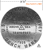
With the GPS, or Global Positioning System, the height of Mammoth Mountain can be measured yearly to detect if the mountain is actually growing, as is believed. The U.S. Geological Survey (USGS) uses what are known as benchmarks to tell the rate of growth of a mountain as compared to the landforms around it. Cemented into place, the benchmark is placed on the summit of the mountain, or the highest point. A tripod, with a GPS monitor attached, is placed directly over the bench mark, and, using triangulation with satellites in the sky, the position of the bench mark is calculated in respect to the other landforms around and the measurements from the years before.
Example of a USGS bench mark from Mt. Rainier
The culmination of this information from Mammoth Mountain provides the definite proof that the mountain is, in fact, growing larger every year.
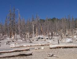
Area of tree kill from carbon dioxide emissions at Horseshoe Lake
Along with the growth of the mountain, an area of growth has also arose concerning the tree kill around Horseshoe Lake . The tree kill was first noticed in the summer of 1990 by Forest Service personnel (Sorey et al. 7). At about the same time, an incident involving a forest ranger occurred; the forest ranger almost asphyxiated to death when he entered a snow-covered cabin that had been closed up for the winter. These bizarre events were investigated and, at first, it was believed that the trees around the Horseshoe Lake might have a disease. However, after the asphyxiation incident with the ranger and tests showing that the trees did not die of disease, gas testing was done. The test showed that the area had extremely high levels of carbon dioxide; levels so high they were deadly. After it was determined that carbon dioxide was killing the trees, where the gas was coming from was looked at. It is believed that the high rate of gas release comes from seismic activity which allowed for more carbon dioxide to be released from its reservoir (Sorey et al. 17). The carbon dioxide reservoir comes from the gas released by the magmatic chamber below, located underneath Mammoth Mountain . As the gas pressure builds, it is released out of the soil and collects close to the ground, as carbon dioxide is heavier than air. When it snows, this heaviness makes the areas around trees and buildings extremely dangerous as the carbon dioxide collects in the areas between the snow and the buildings. For now, gas emissions are being monitored consistently year-round with machines, just as the area of tree kill is being monitored and measured to see if the area is growing or remaining stable.
The hazards associated with Mammoth Mountain have often been highlighted in the media. In the early 1980's, the mountain experienced a lot of seismic activity and began growing at alarming rates. The town was put on alert on May 27, 1982, and though the lowest alert, the town still suffered (Blakeslee). Tourists stayed away from Mammoth and the economy suffered greatly, as tourism is the main source of economy. As the town collapsed, the citizens decided on a way to prevent the problem from happening again. Working with the geologists, a new plan was put into effect; another outlet from Mammoth Mountain was constructed, now called the Mammoth Scenic Loop, and more meetings were held to help the townspeople understand the situation concerning Mammoth. The town did rebuild itself back to what it was before the eruption scare, but that terrible panic still lives with the inhabitants of Mammoth Lake and the geologists who monitor the mountain today.
Long Valley Threat Today and Steps to Mitigate It
Due, in part, to the Mammoth Mountain activity since the 1980's, more attention is being paid to the Long Valley area. There is much speculation about whether or not the area could have an eruption within the near future. Scientists are working on being able to discern where the eruption could take place and how the eruption will affect the surrounding areas. They do this by studying past eruptions against the activity seen today. Looking at the old eruptions, scientists can also tell what kind of eruption could take place based upon what is found in the rock deposits. By using all of the information, they can better prepare for the severity of the eruption and learn the signs that an eruption might be coming in the future. While there is no genuine way to test when an eruption could take place, a great deal of work is being conducted to have better knowledge on how best to mitigate the hazards of an eruption, if one was to occur. “Conditions” are in place, ranging from green to red, with red meaning an eruption is currently taking place (Hill et al. 6-10). There are also plans in effect for how to evacuate the area in case of an eruption. The plans are detailed and precise to help alleviate unnecessary risks and problems associated with evacuation. It is understood that the Long Valley area is at risk for an eruption, though low, and being well prepared is the best and most responsible way to handle the ever lurking hazard.
Conclusions
The history of the Long Valley caldera is long and detailed, with many processes coming together to create the caldera as it is today. The eruption 760,000 years ago was disastrous, but it has become a learning tool that is observed and studied extensively. Though the eruption was massive, the magma chamber below still remains. This magma has resulted in the creation of many of the land formations seen today, such as Mammoth Mountain . The Long Valley caldera is still forming and changing the formations already within the caldera, like the geysers at Hot Creek. All of the activity still taking place, and that has taken place, within the caldera is a great indication of the kind of power the Long Valley still has. This power could translate into an eruption, as previous history of the Long Valley dictates. While there could be an eruption, the people in and around the caldera have made sure to prepare as much as possible. Living in this caldera is somewhat dangerous, but the preparations made, in case of an eruption, lessen the danger and make this unique and beautiful area a great place to live and visit.
References
Blakeslee, Sandra. "Wrong Once, Expert Keep Quiet on Volcanic Activity in California ." The New York Times 11 Sept. 1990. 11 June 2008 http://query.nytimes.com/gst/fullpage.html?res=9C0CE0D9153AF932A2575AC0A9669 58260&sec=&spon=&pagewanted=2
Boiling Water At Hot Creek - the Dangerous and Dynamic Thermal Springs in California 's Long Valley Caldera . USGS and USFS, 2007.
"Geologic History of Long Valley Caldera and the Mono-Inyo Craters volcanic chain, California ." Long Valley Observatory . 14 Oct. 1999. USGS. 10 June 2008 http://lvo.wr.usgs.gov/History.html
Hill, David P. et al. Response Plan for Volcano Hazards in the Long Valley Calder and Mono Craters Region California . USGS. Menlo Park : United States Government Printing Office, 2002. 1-65.
Hill, Mary R. Geology of the Sierra Nevada . Vol. 80. Los Angeles : University of California Press, 2006. 270-276.
" Long Valley Caldera and Mono-Inyo Craters." Long Valley Observatory . 14 Oct. 1999. USGS. 10 June 2008 http://volcano.und.edu/vwdocs/volc_images/north_america/california/long_valley.html
" Mammoth Mountain ." Wikipedia . 12 June 2008. 11 June 2008 http://en.wikipedia.org/wiki/Mammoth_Mountain
Sorey, M. L. et al. "Carbon Dioxide and Helium Emissions From a Reservoir of Magmatic Gas Beneath Mammoth Mountain , California ." Journal of Geophysical Research 103 (1998): 15,303-15,323.
Pictures Citation
Benchmark Picture - http://www.mountainclimb.com/images/promo_l.gif
Bishop Tuff Picture - http://lvo.wr.usgs.gov/gallery/BishopTuff_1.html
Hot Creek Picture - http://pubs.usgs.gov/fs/2007/3045/images/coverphoto.jpg
Long Valley Diagram - http://lvo.wr.usgs.gov/images/lvshd_sites_mask_stripped3.gif
Long Valley Picture - http://volcano.und.edu/vwdocs/volc_images/north_america/california/long_valley.html
