Geology and Natural Heritage of the Long Valley Caldera
Creation of the Sierra Nevada Batholith
Nathan Nahler
Abstract
In the western United States lies one of the largest and highest mountain ranges on earth. Composed of vast quantities of Granitic rock the Sierra Nevada Mountains and the surrounding topography have distinct geologic structures which point to a period of intense deformation and magmatism as the region was formed. Through the analysis of rock types, chemical composition of those rocks, and the actual structures visible in the Sierra Nevada region and further east, it is apparent that many millions of years ago there was a collision between lithospheric plates on the western margin of the North American Plate. This collision caused subduction of the oceanic Farallon plate creating vast masses of magma which rose and crystallized to form the core of the mountain range we see today. In addition to the periods of magmatic intrusion the region went through several different phases of geological setting presenting itself in the sedimentary and metasedimentary rock structures visible today.
Geographic & Geologic Setting
The Sierra Nevada mountain range is the longest and highest such range in the lower 48 United States. The maximum range of elevation is 4400 meters in the south to 2700 meters in the north with a total length approaching 643km (Hill 2006). The range is surrounded by a tectonically active zone on the west coast of North America, primarily in the state of California, with small portions lying within Nevada. Currently to the west of the range lies a large transform plate boundary, the San Andreas Fault, which is still affecting the size and scope of the range today. This fault is the catalyst for many of the well known earthquakes in the California area during modern history (Bolt 2006). Also to the west lies California's central valley, an extremely fertile expanse of land. To the North of the Sierra Nevada lies the Cascade volcanic belt which is still active, with the volcanism a result of the subduction of the Juan De Fuca plate beneath the North American plate (Xue 2007). To the east of the range lies the great basin which is an endorheic or closed drainage basin. It can be inferred by the fact that today the Sierra Nevada are surrounded by such a diverse set of tectonic formations and activity, that plate tectonics itself could be the cause of its creation in the past. The creation of the Sierra Nevada is markedly different from an orogeny resulting from a continental collision at a convergent plate boundary. Where the composition of continental collision ranges such as the Himalayas are primarily sedimentary and meta-sedimentary rocks, the central core of the Sierra Nevada is plutonic rock, which points to a very different mode of formation.
Tectonic History
Plate Tectonics
Through modern science, it has been determined that the theory of plate tectonics is at work throughout the earth. This process allows for rigid oceanic and continental plates to glide above a plastic layer of molten rock called the upper mantle or asthenosphere. Through magnetic seafloor striping evidence, fossil records, and age dating it is now known that the continents of the planet have went through cycles of colliding and rifting. At the beginning of the creation of the Sierra Nevada batholith a supercontinent Pangaea existed. As this continent began to rift apart and move west, a subduction zone was formed on the west coast of the new continent, Laurentia . This subduction zone would have been located geographically in the present day Utah area (Hill 2006). A subduction zone occurs when an oceanic plate collides with a continental plate. Due to a difference in densities caused by the different rock composition, the heavier, colder, and hydrated oceanic crust is pushed below the less dense continental rock (Rondenay, Stephane 2008). This type of subduction is at work in many places currently in the world, including the Philippines, Indonesia, the western coast of South America, and in the Pacific Northwest of the United States. Many landforms in the western United States point to a period of subduction and collision off the west coast of the North American plate. Deep inland, mountain ranges such as the Rocky Mountains and the Black Hills of South Dakota are evidence of an ancient shallow subduction of an oceanic plate (Wells,Hoisch 2008). The presence of large scale plutonic intrusions within the Sierra Nevada also point to crustal melting and magmatism which is associated with deep plate subduction. Currently the United State Geological Survey is tracking what they believe to be a large section of an ancient plate named the Farallon Plate. It is currently under the eastern North American plate, and also gives credence to the theory of a large scale subduction of a plate off the western coast of the North American plate. The presence of the Coco Plate and the Juan De Fuca plate, which are engaged in active subduction, are other clues to the existence of an even larger ancient plate for which these two plates are the remainder (Xue,Allen 2007).
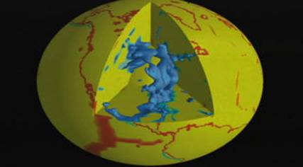
This graphic provided by NASA shows the suspected position of the subducted Farallon plate currently under the eastern North American plate.
When plate subduction occurs, the more dense oceanic plate through the mechanism of slab-pull is drawn deep into the earth's asthenosphere. The oceanic crust is placed under extreme stress causing crustal shortening and thickening. Crustal deformation, folding such as anticlines and synclines as well as fold-thrust belts can occur. At a certain depth of subduction, the crust begins to melt with some melt reconstituting within the mantle while the less dense product of the melt begins to rise and pool closer to the surface of the earth. According to Ellen Syracuse and Geoffrey Abers of Boston University, the point where crustal melting occurs is at the approximate depth of 100 to 120km. This number has been calculated by measuring the distance from the island arc volcanoes and the top of the subducting slab. It is also important to note that the melting point of the subducted oceanic plate is not only affected by the high heat of the upper asthenosphere, but also by the effects of increased pressure and the introduction of water by the hydrated oceanic slab (Iwamori 2000).
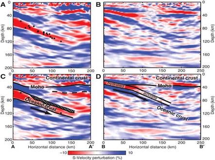
Imaging provided by the USGS shows the subduction of an oceanic plate and the level at which it begins to melt and reconstitute among the country rock, while some melt begins to rise again.
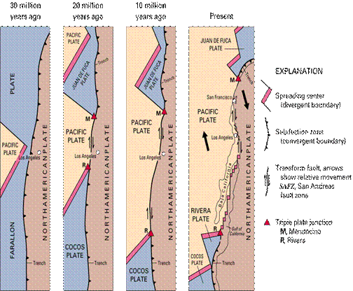
This diagram provided by the United States Geologic Survey shows the approximate process of subduction for the Farallon plate. Note the remnants of the ancient larger plate are now the Cocos and Juan De Fuca plate.
Geologic structure of the Sierra Nevada region
Pre-Mesozoic Rocks
The geologic make up of the region was much different before the Mesozoic era subduction of the Farallon plate began. The majority of the area was covered by a sea which is evident from the Cambrian archaeocyathids discovered above Big Pine, California (Norris, Webb 1990). Continuing north it is observed that various types of sedimentary rocks exist spanning the entire Paleozoic period which is approximately 542mya to 251mya (International Commission on Stratigraphy 2008). McGee Creek canyon's eastern crest is dominated by these uplifted beds of metasedimentary rocks. Directly to the south of the Long Valley Caldera, in the vicinity if Mt. Morrison, 9,700m of chert, marble, slate, quartzite, and hornfels have been cored. All of these again are meta-sedimentary rocks or rocks which have been metamorphosed from their original crystal structure through contact with pressure or heat. In the northern Sierra there is more evidence of Paleozoic volcanism than in the central and southern Sierra (Norris, Webb 1990). Throughout the visible range today there are numerous outcrops or pendants that are composed of these metasedimentary rocks which more specifically were the rocks that were deposited in the region before the subduction of the Farallon plate, and were later metamorphosed into their present day state. A specific example of this metamorphosis would be the limestone of the area coming into contact with high temperatures and pressures and recrystallizing into marble, mostly calcitic, but in some areas dolomitic (Ross 1989).
Rocks dominantly of the Permian age exist throughout the west-central and north-western regions of the Sierra Nevada. Samples of metavolcanic and metasedimentary rocks were found to be 3,000 meters deep and through isotopic dating were placed in the Permian age. All of these metasedimentary rocks can be attributed to a near constant deposition of marine sediments caused by a geosyncline that existed from the Gulf of Mexico to the Arctic. This syncline allowed for periodic filling of this trough from the oceans surrounding the continents. Over several hundred million years the depth and magnitude of this inland sea varied as erosion and uplift worked upon the continent allowing for periods of deposition then periods of erosion (Hill 2006). This deposition of sediments was followed by a deposition of very early Mesozoic volcanic rock. . This was the surrounding geologic landscape at the time the various plutons of the Sierra Nevada batholith began to form (Norris, Webb 1990).
History of the Sierra Nevada Batholith
The core of the Sierra Nevada is composed of a grayish colored, medium to course grained, rock with a very visible crystal structure. These rocks have been identified as granitic rocks which are composed primarily of quartz, mica, feldspar, amphibole and pyroxene (Hill 2006). Granite is an igneous rock which infers that it was released and crystallized beneath the surface of the earth. This mode of crystallization directly affects the grain size of the rock as well as the color and composition. A great majority of the visible rock in the granitic rock of the Sierra Nevada contains small to large K-feldspar crystals. The growth of these crystals has been determined to be caused by fresh magma staying above the point of solidus for a long enough time for the components of the K-Feldspar crystals to form (Moore, Sisson 2008). Isotopic dating of samples taken from several spots along the Sierra Crest, give an age range of 150my for the emplacement of the entire batholith (Norris, Webb 1990). What appear to be different periods of magmatic intrusion are evident in places like Yosemite. At El Capitan it can be noted that the majority of the monolith is created out of uniform composition grey granite, while there are visible dark intrusions of Diorite located within that granite. The geochemical properties of these different types of igneous intrusions have been used to decide what tectonic environment existed at the time of creation. One major chemical composition test is the amount of SiO2 as well as MgO and FeO within the existing rock (Bray 2007). Through the process of Fractional Crystallization, the magma which is cooling beneath the surface of the earth goes through a chemical change in composition. Fractional Crystallization is the process by which the first crystals to cool and fall out of solution are heavier and low in Si02, Potassium, Sodium, and gas content while being more rich in the minerals of Iron and Magnesium. As this process continues the existing magma solution becomes more and more concentrated with Si02, Potassium, Sodium and gas content. Granitic rock is high in SiO2, Potassium, Sodium while being course grained and entirely crystalline (Hamburger 2007).
Interpretation of magmatism
Such a large unbroken amount of granitic rock infers that a massive scale period of volcanism occurred in the area dating back almost 200mya. With the assumption that the Farallon plate was indeed subducting beneath the North American plate it can be interpreted that as the plate reached a depth of at least 100km crustal melting did indeed occur. The body of magma that is present beneath the surface of the earth is less dense than the surrounding country rock. With the aid of gravity the more buoyant magma takes advantage of dykes and existing fractures within the rock to begin rising to a point where equilibrium is reached or the magma is blocked by a retardant layer (Clemens 1998). As the magma body rises it can weaken and sometimes melt the country rock which can enrich the silica content even further. Since there was not an outlet for the magma to reach the surface of the earth, the entire mass of magma that eventually would cool into the pluton had to crystallize beneath the surface of the earth taking many millions of years to cool. As this mass of magma cools and reaches solidus it becomes more dense and reaches a state of equilibrium within the country rock. The different periods of magma intrusion visible throughout the Sierra as well as the varying compositions taken from core samples indicate multiple periods of activity throughout a span of 150my creating a series of plutons which could indicate the changing tectonic environment at the time of intrusion. The Sierra Nevada is composed of many dozen different plutons which rose towards the surface at varying times, temperatures and pressures to create the Sierra Nevada batholith (Norris, Web 1990).
Post-Mesozoic Activity
After this period of intense magmatism and pluton placement a different geologic environment developed once again in the eastern California region. Beginning around 65mya during the Cenozoic age a shallow sea had developed in the area of the modern day central valley on the western margin of the Sierra Nevada batholith. As this sea existed sediment deposition began, visible today as clay, white quartz sand, and even coal bed. This coal is a remnant of a once great forest and plant ecological system that had grown in the region. As this plant material died off it left behind a thick layer of detritus that decomposed into peat and then coal (Hill 2006). Some other Cretaceous sedimentary rock such as sandstones, shales, and basal conglomerates cover the Sierran basement. Following a long period of erosion after the original Nevadan orogeny the land had a relatively low topographical relief, but volcanism did start to change the landscape. During the Cenozoic there is a discontinuous record of volcanic flows and clastic deposits. The non-marine basins began to be filled with a wide degree of different sedimentary rocks as well including lacustrine and fluvial deposits. The volcanic flows and clastic deposits were almost completely removed due to erosion, and the only volcanism from this period is viewed in the northern Sierra (Norris, Webb 1990). Norris and Webb have identified three distinct periods of post-Mesozoic volcanism in the Sierra Nevada. The Valley Springs formation is the oldest outcrop of volcanic rock dated to the late Oligocene or early Miocene or approximately 19.9mya to 33.2mya.
Interpretation of Geologic History
It can be interpreted by the presented evidence that the region now identified as the Sierra Nevada mountain range indeed was subjected to intense tectonic activity which directly resulted in the creation of the unique stratigraphy and geologic formations found in the region. Due to age dating of the various plutons making up the visible Sierra Nevada batholiths as well as dating of the oldest basement plutons it can be inferred that approximately 200mya the Farallon plate began to subduct beneath the North American plate. As the oceanic plate was subducted the water was literally baked out of the rock, and crustal melting began to occur creating the large mass of igneous rock that is visible today (Hill 2006). It is also inferred by the isotopic age dating that there were several distinct periods of intrusion which can account for the dozens of varying compositions of the individual plutons that together form the batholiths. Due to the extreme forces placed on this area of the plate, crustal deformation was caused deep within the plate, and also allowed for a rift our trough to form in the western region of the plate. This plate allowed for marine environments to be created and allowed for the deposition of many thousands of meters of marine sediments, as well as the survival of ecological systems that depended on the water for survival. As the volcanism continued new land was formed to the west of the batholiths, and this continued with the addition of additional terranes being removed from the subducting plate, creating the land visible today as California.
References Cited
Bolt, Bruce A. Earthquakes: Fifth Edition W.H. Freeman and Co, New York, 2006
Clemens, J.D. Observations on the origins and ascent mechanisms of granitic Magmas Journal of the geological Society 1998, V155;issue 5; p.843-851
Hamburger, Michael Fractional Crystallization Indiana University Course Lecture 11/07/07
Hill, Mary Geology of the Sierra Nevada University of California Press, 2006.
International Commission on Stratigraphy Geologic Time Scale http://www.stratigraphy.org/ 06/09/08
Iwamori, Hikaru Deep subduction of H20 and deflection of volcanic chain towards backarc near triple junction due to lower temperature, Earth and Planetary Science Letters 2000, V 181; p.41-46
Moore, James G. and Thomas W. Sisson Igneous phenocrystic origin of K-feldspar megacrysts in granitic rocks from the Sierra Nevada Batholith, Geosphere April 2008; V4;No. 2; p.387-400
Norris, Robert M. and Robert W. Webb. Geology of California: Second Edition. New York John Wiley & Sons,Inc, 1990.
Ross, Donald C. The Metamorphic and Plutonic Rocks of the Southernmost Sierra Nevada, California, and their Tectonic Framework, USGS 1989, Edition 1381.
Syracuse, Ellen M. and Geoffrey A. Abers Global compilation of variations in slab depth beneath arc volcanoes and implications, Geochemistry Geophysics Geosytems, V7, 2006.
Wells, Michael L. and Thomas D. Hoisch The role of mantle delamination in widespread Late Cretaceous extension and magmatism in the Cordilleran orogeny, western United States, GSA Bulletin May/June 2008; V120; no.5/6; p.515-530
Xue, Mei and Richard M. Allen The fate of the Juan De Fuca plate: Implications for a Yellowstone plume head, University of California, Berkely. 2000
Graphic Sources
Farallon Plate: This dynamic earth. USGS, http://pubs.usgs.gov/gip/dynamic/Farallon.html 5/31/08 .
Rondenay, Stephane et.al. Seismic imaging of Subduction zone metamorphism Geology 2008;V36;I4; p 275
Farallon Plate Remnants, Goddard Space Flight Center, NASA. http://svs.gsfc.nasa.gov/vis/a000000/a002400/a002410/ ; 6/10/08