Geology and Natural Heritage of the Long Valley Caldera
Mono Lake: A Dead Sea?
Xoe Higginbottom
ABSTRACT
Mono Lake is a stunning landmark in a vast expanse of stunning landmarks. Formed 3.4 million years ago, the lake is one of few that has survived throughout the ages. Geological records show that the lake has been consistently wet, albeit at varying levels of fullness, from prehistory to the present (D. Marquart, personal communication, 2007). In the early 1900s, the area around the lake was peaceful and serene. Ducks, gulls and grebes flocked to the lakes in numbers near the millions, all feeding on brine shrimp and alkali flies, who in turn feed on the algae that calls the lake home. In 1941, disaster struck. The Los Angeles Department of Water and Power had for years been setting a scheme in motion to lay claim to the water rights in the Mono Basin. The diversions started and little changed, aside from the lake level, for several years. Eventually, a threshold was reached and deleterious effects appeared and intensified almost overnight. Something had to be done, but who would step up to do it? A few good people, dedicated to the cause almost to the point of obsession, formed a group called The Mono Lake Committee, which banded together with other established environmental groups to fight the behemoth threatening their baby, their Mono Lake.Vital Introductory Information
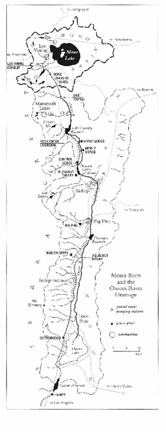
Mono Lake is tucked adorably into a basin in Eastern California . To the west tower the imposing Sierra Nevadas. To the east, the White Mountains , a more relaxed chain. The lake is about 12 miles from side to side and 150 feet deep. The shore has a shallow slope and the water is both salty and alkaline. Two major islands call the lake home. One is a small, black cinder cone, Negit, and the other is large and white, formed by an up swell of potentially eruptible material, Paoha. These two volcanic landforms are part of a chain that extends from the Long Valley Caldera to the Mono Basin . Negit is the youngest of the volcanoes at 300 years old. Paoha emerged in the 17 th century. The lake is home to a unique species of brine shrimp and the alkali fly, and also a bizarre landform called tufa. It also hosts numerous migratory birds. Three major streams feed the lake, Rush Creek , Lee Vining Creek, and Mill Creek, as well as innumerable freshwater springs and several smaller creeks. The lake has no outlet aside from evaporation (Hart, 1996).
Hydrological History of Mono Lake
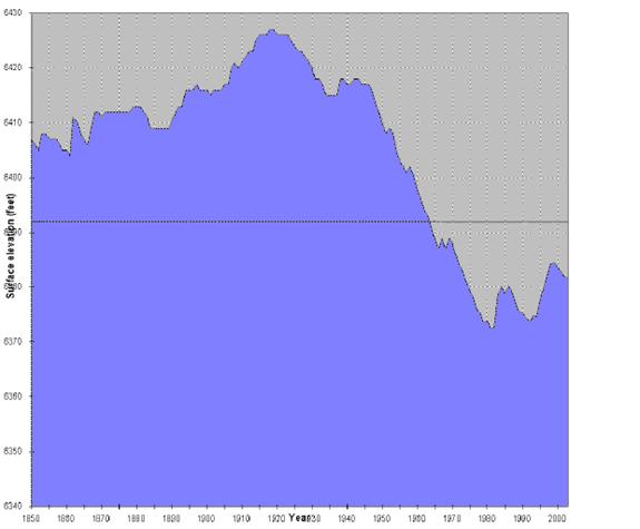
Mono Lake began its life as Russell Lake around 3.4 million years ago. The lake originally had an outlet to the north, which was closed by movements due to faulting. Around 100,000 years ago, the lake was large enough to spill over into the Owens Valley to the south, about 7,200 feet above sea level (monolake.org). The lake fell to its relatively current level around 9,000 years ago and became Mono Lake (Hart 1996). Its highest historical level was attained in 1919 at 6428 feet above sea level. The lowest level in the 20 th century was 6372 feet above sea level in 1982. Its current level is 6385 feet above sea level (monolake.org).
Lake Levels from 1850 through 2000. Taken from monolake.org.
How much water makes it into Mono Lake depends on two factors: precipitation and water diversion. The precipitation comes from both Polar and Pacific weather patterns. Winter is the wettest season and most of the water that eventually makes it into the lake comes from snow. Average annual precipitation in the valley is 6 inches. In the mountains, it's 50 inches. Because the water is seasonal, the stream flows vary significantly throughout the year. The estimate for the average rate of evaporation is 46 inches per year (MBESC, 1987). Water diversion is strictly controlled and will be discussed later.
Scientists try to create hydrological models help them understand the lake more accurately and to predict the impact of particular actions on the future. However, the data used to create these models are not easy to obtain and, as a result, the models have a substantial margin of error. For instance, the main way that water escapes from Mono Lake is by evaporation. It is very difficult to estimate or calculate how much water evaporates in a given period of time. Also, not every stream that flows into Mono Lake has a flow monitoring system present, so the input of these streams must be estimated. The same is true for the underground springs that contribute water from the lake's bottom (MBESC, 1987).
Biological Significance of Mono Lake
Mono Lake is a vital habitat for brine shrimp and alkali flies. A unique species of brine shrimp lives in Mono Lake �Artemia monica. These shrimp are special in that they are the only brine shrimp that can survive in Mono's waters, but they also cannot survive in the water of other lakes. These brine shrimp and flies support large populations of migratory birds. The red-necked phalarope, the Wilson's phalarope, the California gull and the eared grebe all rely on Mono Lake . The phalaropes and grebes use the lake as a refueling station during their flights. These birds can double their weights during a six-week stay at Mono Lake . Sometimes, grebes get so heavy that they have to wait around to lose weight before they can fly away (Marquart, 2007).
A California Gull momma and chick. From monolake.org.
In 1976, a group of Stanford students got a huge grant to do research at Mono Lake . They did a huge study of several aspects of the lake, one of which was its importance as a bird habitat. With 46,000 California gulls, 750,000 eared grebes and 95,000 Wilson 's phalaropes, the vitality of the lake could not be ignored (Hart, 1996). The lake is home to the second largest population of California gulls in the world. These birds nest on Negit island and, like the other birds at Mono Lake , eat brine shrimp and alkali flies (Marquart, 2007). Another study done by a student in the Stanford group endeavored to predict the effects of the lake's declining water level. The student, Robert Loeffler, discovered that the lake would bottom out at 6323 feet above sea level and that its salinity would increase four-fold from the 1976 levels, making the lake seven times saltier than the ocean. Artemia monica die and alkali fly larvae go dormant and do not reach adulthood at twice the 1976 salinity (Hart, 1996). This development would be hugely problematic for the migratory birds that rely on those organisms for food.
Human Impact on Mono Lake
Water is truly the elixir of life. Trees, babies, flowers, cows, cacti, fish, llamas, the lowly brine shrimp and the noble duckbilled platypus all require water. There are places in this world where humans are intended to live. These places generally include a source of food, be it game or forage, a way to create shelter and, most importantly, water. Southern California should give a person aware of these necessities pause because, well, they're not all there. At least, not to the extent that they ought to be.
Water is a fiercely contested and jealously guarded resource in California and the rest of the Western United States, but no one was more fierce and jealous than the city of Los Angeles . Nervous about supplying water to its rapidly growing population and maintaining agriculture that existed in the area, Los Angeles began its quest for water in 1904. Two men who will play important roles in this story, William Mulholland and Fred Eaton, traveled to eastern Sierra to see what was up there. On this trip, Eaton was struck with a brilliant idea: Why not bring this water to Los Angeles ? Two hundred and thirty miles really isn't that far if it's all traveling downhill. What follows is a tale of noble lies as Los Angeles does everything in its power to legally obtain the water rights attached to all of the land in first the Owens Valley and then the Mono Basin . They are ultimately successful and in 1941, Mono Lake water flowed from Los Angeles taps like it belonged there (Carle, 2000).
Taken from Storm Over Mono.
Effects of the Diversions
The first years were exceptionally wet and the lake didn't begin to drop until 1947. Substantial problems began in 1955. Huge tracts of duck habitat disappeared as the sandy beaches were replaced by mud pits and alkali flats. Freshwater springs that had previously bubbled up just past the shore couldn't make their way to the lake once the water had moved down. Both the alkali flies and the brine shrimp got smaller as a defense against rising salinity and several water plants just up and vanished. In 1965, the dust storms began. Alkali dust is particularly unpleasant because the particles are small enough to sneak through one's nose hairs and make their way down into one's lungs, where they cause all sorts of irritation. Alkali dust from Mono Lake causes particular concern because it contains significant amounts of arsenic (Hart, 1996).
Los Angeles 's aqueduct system lacked the capacity to carry all of the water that could possibly be diverted (Carle, 2000). For the lake and streams this was a strange sort of blessing; it meant survival, even if thriving was not an option. However, the state water board saw the water returned to Mono Lake as waste and in 1959 threatened to take away the unused water rights. L.A. really didn't need the water and, thanks to other water projects and conservation efforts, it never would. But no one in California gives up any water rights ever, so a second tunnel was built on the aqueduct in 1970 (Hart, 1996).
Despite a successful demand from Inyo County for L.A. to produce Environmental Impact Reports detailing the effects of their actions in Owens Valley, both the people who lived around Mono Lake and most environmental advocacy groups felt that Los Angeles was just too big of an opponent or that Mono Lake was just too far gone or that there was simply nothing to grasp at, no possible way to make a case. Yes, what was happening was pretty bad, but it was entirely legal; the water was going for the most important use. Mobilization was difficult until the story of the potential for a land bridge onto Negit broke (Hart, 1996). Negit is where the California gulls nest and a land bridge would allow predators to find their way onto the island. After such an intrusion, the gulls may never come back, even with the land bridge gone (Marquart, 2007).
The land bridge to Negit Island . From Storm Over Mono . Photograph by Betty Shannon.
What is to be done?
Two intensely dedicated men, David Winkler and David Gaines, formed the Mono Lake Committee in 1978 as a response to the lack of enthusiasm shown by established environmental groups about the plight of Mono Lake . The group had six goals:
��It would publicize the situation at the lake and try to sway public opinion.
--It would work to draw visitors to the lake.
--It would encourage research and publicize the results.
--It would lobby the legislature to enact laws protecting Mono Lake
--I would draw attention to the growing dust-storm problems and seek recourse through the air pollution laws.
--It would, if it could find a legal basis, take Los Angeles to court.�
(Hart, 1996).
The Mono Lake Committee got off to a very ambitious start, demanding a minimum lake level of 6,378 feet�the lake level at 1979�and absolutely refusing to budge. The City of Los Angeles originally claimed it could never just stop using the Mono Basin water, the water would have to be replaced from somewhere else. However, during a drought in 1976-1977, the city reduced its water usage by 19%. A twelve percent reduction would have been enough to eliminate the need for water from Mono Basin (Hart, 1996).
Even with the support rallied, there still needed to be a legal basis calling for the protection of Mono Lake . The legal opinion of the time was that, while the effects of the diversion may be regrettable, some ducks and gulls could not be allowed to get in the way of progress. One dedicated law student, however, found an answer. His name was Tim Such. His solution: The Public Trust.
The Public Trust
According to John Hart, the public trust is the �concept that certain lands and resources belong to the whole people and that the government, which serves as guardian, has an inescapable duty to manage these properties well.� The law dates back to the Romans and specifically applies to, among other things, navigable bodies of water. However, before the Mono Lake case, the law was rarely spoken of. It lay hidden in the annals of law libraries on college campuses all over the country, but hadn't really ever seen the light of day in American law. An important aspect of the public trust doctrine is that there is no statute of limitations. Even though the abuse had been going on for decades, it would never be legally too late to prosecute the offenders. However, the idea would also have to be stretched a little. Mono Lake wasn't specifically being targeted and the creeks that were were not navigable. Tim Such was willing to take that chance and he ultimately got the Audubon Society, the Sierra Club, the Mono Lake Committee and the Law Office of Morrison and Foerster to sign on with him (Hart, 1996).
The Trial
In 1979, the Public Trust suit began. It was ultimately decided in the California Supreme Court in favor of Mono Lake . The decision had little in the way of enforcement, however, and diversions continued essentially without pause. It wasn't until 1984 that anything substantive was done to address the problem. The Mammoth Fly Rodders began this particular effort, stating that the Fish and Game Code had been violated when the original water diversion licenses were issued to the Los Angeles Department of Water and Power (monolake.org). This code requires that all dams and diversions provide a way to maintain existing fish life downstream. The regulation was flouted in an agreement that built a new fish hatchery with LADWP money in place of maintaining the fisheries in the streams (Carle, 2000). Even this pressure wasn't enough on the LADWP and in 1990, the suit was brought again, accusing LADWP of ignoring the decision and noncompliance. Finally, an injunction was filed requiring that the diversions let through enough water downstream to maintain the fisheries.
On September 28 th , 1994, the State Water Resources Control Board finally figured out a solution.
The Solution
After several decades of fighting, a solution was finally reached balancing the needs of the lake and the city. Minimum flows for all of the diverted streams have been mandated based upon the amount of water available that year (monolake.org). In 1941, biologist Elden Vestal suggested a minimum flow for Rush Creek of 5 cubic-feet per second to maintain fish populations there (Hart, 1996). The final decision by the Water Control Board was between 31 and 68 cubic-feet per second (monolake.org). There are also two sets of requirements for the lake level. The first set says that no diversions may take place if the lake is below 6,377 feet; 4,500 acre-feet may be diverted if the lake is between 6,377 and 6,380 feet; and 16,000 acre-feet may be diverted if the lake is between 6,381 and 6,391 feet. After 6,391 feet, a new set of rules takes effect. The lake may no longer be diverted if water level falls below 6,388 feet; 10,000 acre-feet may be diverted if lake levels are between 6,388 and 6,391 feet; and all water in excess of the requirements for minimum stream flows may be diverted as long as the lake is above 6,392 feet (monolake.org).
Mono Lake is well on its way to recovery. The battle is considered won.
Works Cited
Carle, David. Drowning the Dream: California 's Water Choices at the Millennium. Praeger: London , 2000.
Hart, John. Storm Over Mono: the Mono Lake Battle and the California Water Future . University of California Press: Berkley , 1996.
Mono Basin Ecosystems Study Committee (MBESC). The Mono Basin Ecosystem: Effects of Changing Lake Level . National Academy Press: Washington , DC , 1987.
Mono Lake Committee website: http://www.monolake.org/index.html
Mono Lake Committee , Mono Basin Clearinghouse website: http://www.monobasinresearch.org