Geology and Natural Heritage of the Long Valley Caldera
The Salty Siren: Death Valley
Courtney Cole
ABSTRACT
The ambiance of Death Valley is the part of what makes Death Valley so intriguing and attractive to visitors and geologists a like. Throughout this paper I will be discussing the general tectonic activity within Death Valley, as well as a general overview of the valley itself. I also focus on particular features of the valley such as major fault zones and volcanic activity. When discussing faulting, I will focus on Furnace Creek fault, Amargosa Chaos, and also draw attention to the fault zones and the Basin and Range Province. The connection to faulting and volcanism in Death Valley, as in other parts of the world as well, cannot be avoided. In discussing volcanism I will focus on the Ubehebe Crater and the Ubehebe volcanic field. Finally I will cover some of the most fascinating parts of Death Valley; the saltpan, sand dunes, alluvial fans, and glacial lakes. All of this activity within Death Valley makes it the most fascinating place I have ever visited.
Death Valley is one of the most fascinating places on earth, from the very active faulting to the expansive salt flats that coat the floor of the valley. Death Valley is described as one of the hottest, driest places on the planet with temperatures in the summer ranging from around one hundred degrees Fahrenheit to one hundred and thirty-four degrees Fahrenheit with only around an inch and a half of precipitation a year (Hunt 1975). These raging hot temperatures have much to do with Death Valley being around two hundred and eighty-two feet below sea level near Badwater on the eastern side of the valley (Sharp 1997). The most fascinating part of Death Valley is the vast expanse of salt coating the valley floor and the processes that form this film. Death Valley is what I like to call the ‘Salty Siren' of the American west. For many scientists, though, the pull to Death Valley rests mostly in the extensive and very active fault zones occurred along the margins of the valley. Death Valley's surroundings give many examples of its existence within the Basin and Range Province .
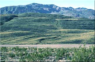
Death Valley lies to the east of the Sierra Nevada Mountains and is part of the Great Basin . On the eastern edge of Death Valley you have the Panamint Range, which contains the Cottonwood Mountains and to the west coming from north to south there are the Grapevine Mountains , Funeral Mountains , and the Black Mountains . To the South of Death Valley is the Mojave Desert . The beautiful setting that Death Valley resides in now was not always so quiet and peaceful in the past. Death Valley is relatively young, very possibly only a few million years, compared to some of its surroundings. Two different types of tectonic movement caused the volcanism in the area. Approximately ten million years ago the tectonic setting affecting California was a subduction zone off the coast, but then the tectonic setting switched after most of the original plate was subducted (Sharp 1997). The most recent tectonic activity in the form of extensive faulting is caused by the Basin and Range province, which essentially is the stretching of the western United States due to the pulling of the Pacific plate along the North American plate (Blakely, et al. 1999). The Basin and Range province is responsible for the large amounts of volcanic activity in the Death Valley Region as well as the volcanism of Mammoth Mountain and the Long Valley Caldera (Sharp 1997). The effects of the continental pull are felt throughout the American West, not just in California and Nevada . The fault zones in the Basin and Range province traditionally run generally north to south and within these fault zones, normal faults are the most common. In many instances this general faulting trend is logical because of the east to west pulling of the western states (Sharp 1997). While keeping this in mind I am going to explore some of the main features of Death Valley, their geologic formation, and some of the desert features that make Death Valley a unique place to visit.
One of the most spectacular examples of faulting within Death Valley is in Furnace Creek fault. The Furnace Creek Fault is located south of the Grapevine Mountains and north of the Black Mountains on the northeastern side of Death Valley (Wright, et al 1999). The fault lines are so clear in the northwestern portion that tens of feet of displacement can be seen and measured in this area of Furnace Creek (Wright, et al 1999). The connection between volcanism and faulting can also be detected here with the presence of metamorphic rock in the region (Wright, et al 1999). The Furnace Creek Fault is classified as a strike-slip fault, even though the stretching of the United States causes the faulting (Wright, et al 1999). There are many normal faults located in the area, which coincide with the Basin and Range province and the faulting that occurs as a result (Wright, et al 1999). Some of the passed volcanism caused by the faulting in the Furnace Creek fault area can be seen in the metamorphism in the Badwater Turtleback and the Black Mountains (Wright, et al 1999). Most of the rocks with in the Black Mountains and the Turtleback are gneiss, which is rock that is so metamorphosed that the original composition cannot be concluded (Wright, et al 1999). This level of metamorphism makes it impossible to date the rock. The faulting in the Great Basin and Death Valley area most certainly does not end with the Furnace Creek fault, but also occurred in other parts of Death Valley as well.
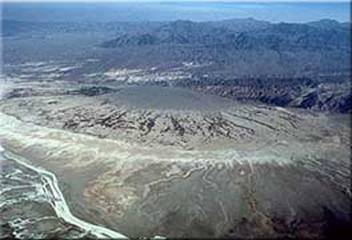
A photograph of the large alluvial fan at Furnace Creek. (Photo: USGS website 2004)
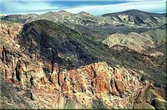
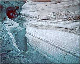
Taking the concept of faulting and uplift to an extreme level, one of the prime examples of the extreme faulting and uplift in the area is Amargosa Chaos. According to the United States Geological Survey the beginning of metamorphism of rocks in the area occurred approximately 1.8 billion years ago (USGS website 2004). The chaotic appearance of the Amargosa Chaos is caused by a substantial thrust fault (Hunt 1975). There has been such extraordinary amount of thrusting and faulting in the area that dating the rocks and figuring out a stratigraphy is nearly impossible (Hunt 1975). In some areas of the chaos there are areas where igneous rocks have intruded themselves in to the broken up, jumbled rocks (Hunt 1975). Most recently the area has been affected by the stretching of the western United States , which is responsible for most if not all of the faulting in the region (Hunt 1975). The stretching causes faulting, which creates fractures, or crack, that can allow for magma's movement to the surface of the earth's crust. Death Valley has been plagued by volcanism form billions of years and a fascinating place it occurs is in the Ubehebe volcanic field.
A photograph of the Amargosa Chaos. (Photo: USGS website 2004)
One of the largest and most recent volcanic eruptions happened in the Ubehebe volcanic field. The Ubehebe Crater is located to the north of the Cottonwood Mountains , which lie within the Panamint Range to the west of Death Valley (Sharp 1997). The large crater was caused by a hydrovolcanic eruption that occurred approximately two thousand years ago (Sharp 1997). The water within the bedrock acted as an accelerant and caused the eruption to be very violent and very large (USGS website 2004). The magma that came to the surface did so through fractures and weakened areas caused by faulting within the valley area (Sharp 1997). The main Ubehebe Crater had basaltic lava flow as well as a very large fast moving pyroclasitc flow (USGS website 2004). Most of the lava, however, did not reach the surface, but rather splattered and left interesting patterns as the volcano erupted (Sharp 1997). The Ubehebe Crater is part of approximately twelve volcanic craters within the field (USGS website 2004). The Ubehebe Volcanic field is a fascinating area with a very rich and very explosive history, but not all of the spectacular features in Death Valley were caused by volcanism.
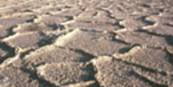
On my visit to Death Valley , it was fascinating to see the beauty of the salt resting on the valley floor. When it rains, or if the snowmelt is substantial in Death Valley, water and minerals are carried from the mountains, flow down the alluvial fans and into the basin ( Clark 1981). Because there is no outlet to the ocean from Death Valley and the temperatures are so extreme, the precipitation evaporates very quickly leaving salt and other minerals behind (Sharp 1997). The pans, or flats, are approximately an average of two to three feet thick and are composed of various types of salt (Hunt 1975). After rainfall when the salt is drying out, it contracts and forms polygon shapes within the flats (Sharp 1997). From Dante's Viewpoint the salt flats appear smooth and without any contours, but while walking on the flats themselves it becomes apparent that there is definite texture and shape to the flats. The salty layers as well as some of the silt and mud on the valley floor, peel off the floor like the skin of an orange when precipitation evaporates. The salt flats in Death Valley are not the only amazing feature I experienced in California , but the sand dunes were miraculous. (Photo: USGS website 2004).
A photograph showing the polygons that form in the Death Valley saltpans
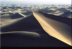
While visiting Death Valley one of the most interesting and strange features to see are the sand dunes that are found in and around the valley. Most of the sand is blown from the mountains as erosional sediment (Sharp 1997). Because of the location of the mountains around the valley, the winds blow in a way that is conducive to the formation of the sand dunes (Sharp 1997). An interesting observation to make is the tilt of the dunes and the ripple marks that appear in the sand. The wind carries the sand over the ground and as the sand reaches a “road block” like a rock or possibly a sand dune, the wind drops the sand creating a mound. If the wind continues to blow in that same direction, the wind will drop the sand at the crest of the mound (Sharp 1997). There are the large mounds of sand that are visible from a distance that the wind deposits the sand, but there are also the very small ripples that serve as a smaller version of the large sand dunes (Sharp 1997). Sand dunes are mostly moved and shaped by wind, another feature, alluvial fans, are shaped by water. Though both are deposited in similar ways, they are both very common sites in Death Valley.
A photograph showing the sand dunes of Death Valley ; notice the angle and lean of the dunes. (Photo: USGS website 2004)
Alluvial fans are beautiful features within Death Valley that reach out like fish fins from the mountainsides. The alluvial fans of Death Valley are created by floods and precipitation that pick up sediment as it rolls down the mountainside and then deposits the sediments at the base of the alluvial fan (Sharp 1997). From my own observations of the alluvial fans in Death Valley , the clast sizes with in the alluvial fans vary highly. In some instances I observed sand sized particles, but in other instances I discovered softball size clasts and larger. The alluvial fans along the Panamint Range are much larger than those of the Black Mountains, because the Panamint Range is larger and receives more precipitation; the alluvial fans are larger (Sharp 1997). From that information I conclude that the more rainfall and snowmelt that occurs the more water flows down the alluvial fans and the faster the water moves. The particle size water can carry has a large amount to do with the speed of the water; meaning faster moving water carries more sediment. Some of the most extraordinary and perfect alluvial fans can be seen near Badwater (Sharp 1997). Not only are features such as the alluvial fans and the sand dunes created by water and the deposition of sediment, but also such features as Mosaic Canyon .
One of my favorite features within Death Valley is Mosaic Canyon , because of the beautiful colors and the rich history of the feature. Mosaic Canyon is on the north side of the Panamint Range and was shaped and formed by large amounts of water flowing through the area (Sharp 1997). Early in Mosaic Canyon 's history it was covered by a shallow, warm sea, causing some of the original, sedimentary depositional environments in the area (USGS website 2004). Water has the ability to cause large amounts of change and in a short amount of time. Mosaic Canyon was formed mostly from the processes of “…filling and scouring out” of the rock (Sharp 1997). According to the United States Geological Survey the gorgeous marble within Mosaic canyon was created by high heat and pressure from underground heating up buried dolomite and metamorphosing it into marble (USGS website 2004). Most of the rock in Mosaic Canyon is around seven hundred million years old and is known as the Noonday Dolomite (Sharp 1997). One will also find very angular rocks that are suspended in a fine-grained matrix, also known as breccia throughout the canyon (Sharp 1997). Because of the tectonic activity in the region in and around Death Valley, Mosaic Canyon has been uplifted, which exposed the beautiful dolomites and marbles within the canyon (USGS website 2004). Another feature that reveals its past as the floor of a shallow sea is Titus Canyon near the Grapevine Mountains .
The photograph on the following page shows some of the exposed marble and breccia of Mosaic canyon. (Photo: USGS website 2004)
Titus Canyon has a similarity with Mosaic Canyon due to one of the main depositional environment for both places was a shallow sea. Titus Canyon cuts deep into the side of the Grapevine Mountains , which lie northeast of Death Valley (Cemen 1999). The Titus Canyon formation is mostly made up of limestone dating back to approximately five hundred million years old (USGS website 2004). Within these shallow seas colonies of algae called, stromatolites, formed aiding in the formation of the limestone found on the canyon wall (USGS website 2004). Other types of sedimentary rocks also point to a body of water that lifted and lowered in level resided over the Titus Canyon many millions of years ago. There are such rocks as sandstone as wells as mudstones, shale, and sandstones with larger clast sizes (Blakely, et al 1999). These rocks help support the idea that the water level teetered back and forth through time. Tectonically speaking Titus Canyon formation and the Grapevine Mountains are relatively new in geological time, because of the recent uplift of the area (USGS website 2004). Depositional environments caused by water are very significant and prevalent especially in an area that receives so little precipitation during the year, but not to be dismissed is the glaciations and its effect on the Death Valley region.
Though Death Valley is a basin and water would naturally collect there, glaciers that moved through the valley during the Pleistocene also had a great effect on the topography and climate of the region. According to one of the sources that I consulted, there were possibly several lakes that existed in Death Valley after the Pleistocene glaciations (Hunt 1975). Some of the lake deposits can be seen on a few of the alluvial fans that stretch from the sides of the mountains bordering Death Valley (Hunt 1975). Geologists would look and the clasts and try to determine their origin as a way of investigating the glacier. The evidence of one of Death Valley 's most recent and significant lakes can be found on Shoreline Butte (Hunt 1975). The Shoreline Butte was at one point an island in Lake Manly and shows the change in the lake's water level as the glaciers receded and the temperatures in the valley rose (USGS website 2004). The waves of the lake would crash against the butte or island and create terraces, which can still be seen today (USGS website 2004). The evidence of Lake Manly on Shoreline Butte is one of the clearest examples of the glacial lakes, because many of them were very shallow and small in comparison and did not have a great affect on the bedrock in the valley (USGS website 2004). It is difficult to tell the depth of the lakes that occurred during the Pleistocene, because of the effect of faulting on the valley floor (Hunt 1975). These smaller lakes of Death Valley are considered responsible for the Death Valley Salt Pan, because of the final evaporation of the last remaining lakes (Hunt 1975). Death Valley has a rich history spanning from wet and cold to hot and extremely arid.
Photograph showing the terraces that are visible on Shoreline Butte; evidence of the Pleistocene lake, Lake Manly.
Death Valley has a very complex and extreme story it shares with diverse visitors every year. Geologists study the region still today and tourists visit it to marvel at the valley's strange and beautiful features and formations. The history of Death Valley started like most of the western United States , as a shallow sea. From there tectonic activity in the form of subduction of plates under North America and the stretching of the continent, reeked havoc on the valley and caused the mountains to lift and the valley to fall. Glaciers then moved in forming lakes and dropping the temperatures of the area, creating a landscape and climate very different from what visitors see in Death Valley today. One of the most identifying features of Death Valley is the saltpan that stretches across a vast amount of the valley floor. Like the topography in the Death Valley region, even the saltpan is diverse in its composition. Because of the volcanism and the sedimentary depositional environments, the rock records are all over the spectrum. The valley has basalt to shale and mudstone to granite and even gneiss. The history and assumptions cannot be made about Death Valley , because it has as many variations as there are minutes or seconds in the day. For me this diversity in all facets of Death Valley 's history, make it the most marvelous place to visit and study.
Works Cited
Blakely, Richard J., et al. “Cenozoic basins of the Death Valley extended Terrane as reflected in Regional-scale Gravity Anomalies.” Cenozoic Basins of the Death Valley Region . Ed. Lauren A. Wright and Bennie W. Troxel. Boulder, CO: The Geological Society of America, 1999.
Cemen, Ibrahim, Lauren A. Wright, Anthony R. Prave. “Stratigraphy and Tectonic implications of the Latest Oligocene and early Miocene Sedimentary Succession, Southernmost Funeral Mountains, Death Valley Region, California.” Cenozoic Basins of the Death Valley Region . Ed. Lauren A. Wright and Bennie W. Troxel. Boulder, CO: The Geological Society of America , 1999.
Chalfant, W.A. Death Valley : The Facts . Stanford University , CA : Stanford University Press, 1933.
Clark, William D. Death Valley : The Story Behind the Scenery . Las Vegas : KC Publications, 1981.
Death Valley National Park Virtual Geology Field Trip . 1 Jan. 2004. United States Geological Survey. 6 Jun. 2007 <http://geology.wr.usgs.gov/parks/deva/devaft.html> (All of the photographs used in this paper were from this website.)
Faunt, Claudia C. Effect of Faulting on Ground-Water Movement in the Death Valley Region, Nevada and California. Denver, CO: U.S. Geological Survey, 1997. (This source was used to double check the geography of the Death Valley area. Only the map was used.)
Hunt, Charles B. Death Valley : Geology, Ecology, Archaeology. Berkeley, CA: University of California Press, 1975.
Sharp, Robert P., and Allen F. Glazner. Geology Underfoot in Death Valley and Owens Valley. Missoula, MT: Mountain Press Publishing Company, 1997.
Wright, Lauren A., et al. “Tectonostratigraphic development of the Miocene-Pliocene Furnace Creek Basin and related features, Death Valley region, California.” Cenozoic Basins of the Death Valley Region. Ed. Lauren A. Wright and Bennie W. Troxel. Boulder, CO: The Geological Society of America , 1999.