Geology and Natural Heritage of the Long Valley Caldera
A Presentation of the Various
Aspects of Mono Lake
Sarah Jane Pepper
Abstract
This paper will address issues concerning Mono Lake and the surrounding Mono Basin including their creation and the processes that have led to the landscape we see today. Geologic processes of tectonics and volcanism in the Mono Basin, specifications to Mono Lake including water chemistry, a summary of the biota found in the region, and the anthropogenic impacts on the area will be discussed.
Introduction
Deep down, springs bubble through majestic forms rising to shining light above. In the depths phytoplankton drift while nearer to the surface the water teems with wriggling brine shrimp. The webbed feet of California gulls and phalaropes dangle under the water; the birds are oblivious to anything except the buffet they are sitting on. At the shore buzzing clouds of alkali flies hum; beyond their swirling mass the evidence of North America's most recent volcanic activity breaks the horizon.
All ecosystems are unique and deserve attention; Mono Lake is particularly interesting with sciences intertwining to explain the incredible features of the area. This lake has importance not just to the biota that depend on it, but also the humans that enjoy it, learn from it, and fight to protect it. This paper will provide a background on the processes that led to the formation of the lake and the surrounding area, the animals and plants unique to this location, and discuss the effects of people on the lake.
Geology of the Mono Basin
Physiography
The Mono Basin lies 300 miles north of Los Angeles and 150 miles east of San Francisco. It is bordered to the west by the Sierra Nevada, to the southeast by the White Mountains, and to the south by the Mono Craters (National Academy of Science 1). Three million years ago a freshwater lake existed in the basin with an outlet to the north (Hart 7). While other terminal lakes in the Great Basin began disappearing after the Long Valley eruption, Mono Lake remained because of its location; its high altitude and shelter from the nearby Sierras reduce the amount of evaporation coming off the lake (10).
The creation of the Sierras can be attributed to the subduction of the Farallon plate beneath North America, which meant the continent smashed into the Pacific plate, directly to the west of Farallon. Instead of subducting, however, this collision resulted in a shearing of the Pacific plate against North America. As Farallon has continued its subduction and the Pacific plate continues to shear against the coast of western North America, the bottom of the continental plate has been exposed to the mantle (Tierney 29). This has led to the formation of the Basin and Range province which the Sierra Nevada is the westernmost boundary of. This area is characterized by blocks of crust that have sunk or raised relative to one another, creating a system of mountain chains and basins that run parallel to one another (30).
Other features of the basin also have interesting origins; Black Point, just off the north shore, was formed by an eruption approximately 13,800 years ago during the last ice age (Gaines 6). Many physical features on the south rim of the basin attribute their formation to volcanic eruptions.
Tectonic Setting
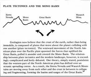
According to author John Hart, the Mono Basin is a result of fracturing across Nevada from a collision between the Sierra Nevada and a high plateau to the east that took place 3-4 million years ago (8). Robert Mohlenbrock agrees that the basin is a direct result of a Sierran uplift (50). David Gains, author of the Mono Lake Guidebook, points out that despite the upward action of the mountains the Mono Basin is due to the continual sinking of the actual basin floor (35). The following image from page 35 of the Mono Lake Guidebook illustrates this point.
The portion that is the basin has been sinking for millions of years, but it was not until much later that the area was surrounded by today's features. The sinking of the crust here is a primary attribution of the lake's status as the second-oldest lake in North America; Lake Tahoe is the oldest. Unlike other lakes which are eventually filled with sediment, the bottoms of Lake Tahoe and Mono Lake are sinking faster than the sediment can build up. Evidence that this region is still tectonically active can be observed; in 1878 an earthquake in the Owens Valley caused the valley to drop 13 feet compared to its recorded height prior to the quake (Strong 50). Hot springs along the shoreline of Mono Lake and on the islands suggest future tectonic activity.
Volcanism
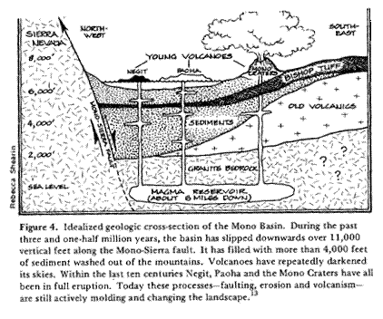
The Long Valley eruption is the most notable volcanic event in the history of this area. It took place 730,000 years ago and spewed ash 150 cubic miles (Tierney 47). While ash from the eruption can be found anywhere between Los Angeles and Nebraska, it fell most thickly in immediate areas including the Mono Basin, Adobe Valley, and Owens Valley. Over time the ash has been compressed into rocks now known as the Bishop Tuff, which reaches depths of 600 feet in those surrounding areas and 3,000 feet in Long Valley Caldera, the depression left by the massive blast (Tierney 48). Sediments from the bottom of Mono Lake indicate a dousing of this ash: distinct layers of sediment can be found above and below a layer of tuff that was dispersed over the lake and sank to the bottom (Hart 15). Mono Craters, Black Point, and Negit Island are all evidence of recent volcanic activity in the Mono Basin ( www.monolake.org/naturalhistory/volcanic .htm).
The formation of the Mono Craters began around 35,000 years ago, and the last recorded activity was 600 years ago (http://www.und.edu/instruct/mineral/303Calif/). Several of the Mono Craters rise as much as 2,600 feet above their surroundings (Gaines 11). The domes are the result of rhyolitic explosions (http://www.und.edu/instruct/mineral/303Calif/). Panum Crater is the youngest of the Mono Craters, having erupted a mere 640 years ago (Gaines 12). The explosion was marked by ash, a pumice ring, and finally a lava eruption that, instead of exploding, plugged the cinder cone in a fashion similar to that of toothpaste being squeezed from a tube (Gaines 12).
Black Point, on the north shore of Mono Lake, represents the youngest of the mafic lavas in the area, having erupted 13,300 years ago (volcano.und). Although it is currently a surface feature of the Mono Basin, during its formation Black Point was actually underwater; this explains its unique beveled top (Hart 13). After its subsurface eruption at the bottom of Mono Lake, the peak of the volcano must have extended out of the water where it was smoothed flat by water erosion (Hart 13). The lakewater caused the core of the cinder cone to cool so fast that the lava cracked, resulting in the fissures atop Black Point that can be explored today (Hart 13).
Negit Island, the darker of Mono Lake's two islands, was formed between 1,700 and 300 years ago and is attributed to an underwater eruption (Hart 14). Famous for its light color, Paoha, Mono Lake's other island, also resulted from an eruption; but instead of rising to the surface of the lake, it pushed up a large mound of the lake sediment. The dark sediment oxidized and turned white when it reached the surface (Strong 50). The following illustration shows volcanic impacts on the area.
(Gaines 27)Climate
The Mono Basin has the highest elevation of the four great American deserts and also experiences the coldest mean temperatures ( www.monolake.org/naturalhistory/greatbasin.htm ). The area receives 6-13 inches of precipitation a year, with 80 percent of that between November and April in the form of snow (Gaines 24). After a storm on cool days the poconip , or dense fog, covers the basin and leaves a dusting of frost (Gaines 24). In the spring and fall winds are common, some reaching speeds of 100 miles per hour; and during the summer thunderstorms often form, although they do little to quench the area's thirsty soil (Gaines 24).
Mono Lake
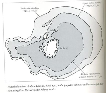
The shape and the size of Mono Lake have been changing constantly since its beginnings around 3 million years ago (Hart 7). Although today it is measured as roughly 12 miles across and 150 feet deep (Hart 6), 12,000 years ago Mono Lake reached a level so high that it spilled over the basin to the east and south, draining into the Owens Valley (Hart 10). This transgression can be attributed to the melting of glaciers at the end of the Pleistocene era (www.wetmaap.org). The deepest record of the lake is 900 feet and the widest record is 358 square miles (Mohlenbrock 50). The town of Lee Vining sits on top of the Lee Vining Creek delta; 20,000-15,000 years ago this location represented the shore of the lake (Hart 16). Twelve thousand five hundred years ago the shoreline rose hundreds of feet above this height (Hart 17). During recent history from the years of 1941-1996 the lake dropped forty feet (National Academy of Science 2). Land bridges to the islands were exposed at 6,350 feet, and the habitat of Mono Lake's simple food web was threatened by concentrations of minerals and vulnerability to predators who had gained new found access to the islands (National Academy of Science 4). In addition to these concerns, the surface level of the lake has a significant impact on the height of the surrounding area's water table, putting significant stress on vegetation (National Academy of Science 4).
Water Chemistry
Processes of Composition
Mono Lake is fed by water from the Sierras from Mill, Lee Vining, and Rush creeks (Hart 6). The saltiness of the lake is due to the minerals carried in the freshwater from the streams (Gaines 19). Volcanic eruptions in the area have also contributed to the composition of the lake. Some scientists estimate that these two inputs, along with the estimated four vertical feet of the water the lake loses each year to evaporation, result in over 280 million tons of dissolved solids in Mono Lake ( www.monolake.org/nautralhistory/chemistry.htm ). However, David Gaines estimates there are even more dissolved minerals: 340 million tons, which is more than a pound of minerals per gallon of water (19). The figures describe a lake three times as salty as the ocean and eighty times as alkaline (Gaines 15). The following minerals are found in the highest concentrations: sodium chloride, sodium sulfate, and sodium carbonate (Gaines 20). In addition to these, the lake is also high in fluoride, boron, and arsenic (Hart 14). The combination of the various elements results in a pH of 10, which is comparable to household glass cleaner ( www.monolake.org/naturalhistory/chemistry.htm ).
Mono Lake's water faces fascinating consequences from its unique composition. The thermal properties of the water are altered by the dissolved minerals, making it easier to heat than freshwater; the lake water also has a viscosity 20 percent higher than that of freshwater (National Academy of Science 51). Mono Lake regularly experienced a full mixing once a year in the late fall; then it began to stratify itself into thermal layers of freshwater and lake water in late March (National Academy of Science 53). Depth and salinity influence the stratification of the lake water (National Academy of Science 49). Meromixis is the phenomenon defined by a definite un-mixing of the lighter freshwater near the surface of the lake from the denser lake water, which sinks to the lower half (National Academy of Science 4). Beginning in 1982 the lake received a large influx of freshwater because of both the reduction in diversions from its feeder streams and an unusually heavy snowfall. The result was meromixis of the lake (National Academy of Science 4).
Tufa Formation
The tufa towers are perhaps one of the most memorable features of Mono Lake. Tufa is created by the mixing of subsurface freshwater springs and lake water (Hart 21). When carbonate ions present in the lake water come into contact with calcium ions in the freshwater, the product is calcium carbonate (Hart 20). Calcium carbonate is also known as calcite and is commonly referred to as limestone (Gaines 6). Underwater towers continue to grow; bubbles at the surface indicate a forming tower growing vertically below. However, the towers exposed on the shores are considered “dead” because the springs that formed them are gone and they will eventually be eroded by wind and water (Hart 21). Tufa that dates back to the ice age can be found hundreds of feet above the current shore, evidence of the high lake levels of the past (Gaines 22). Sand tufa, which is very delicate, forms when sediments that are saturated with the lake brine come into contact with freshwater (Gaines 21).
Biotic Characteristics of Mono Lake
Introduction to the Biota at Mono Lake
Mono Lake supports a unique and limited group of plants and animals. Those organisms that have withstood the lake's harsh conditions, both natural and anthropogenic, exist within a delicate balance. As researchers continue to learn more about the ecosystem of Mono Lake the amazing adaptations and relationships in the food web here become apparent.
Bacteria
Unfortunately bacteria in special aquatic environments such as saline and alkaline lakes have yet to be studied in depth; however, it is hypothesized that bacteria play a significant role as primary producers and decomposers in the Mono Lake ecosystem (National Academy of Science 70). Recently an exciting discovery was made by microbiologists Richard Hoover and Elena Pikota on the shores of the lake. A species of bacteria that has never before been identified was found living in the salty, alkaline, oxygenless mud (Mohlenbrock 50). This discovery may spawn new research on this topic at Mono Lake and perhaps other similar locations as well.
Algae
Benthic and planktonic algae live in the water, serving as primary producers, food for brine shrimp and alkali flies (National Academy of Science 1). The plankton have heightened populations during the fall and winter when the brine shrimp populations begin to decrease and then disappear during the cold months (National Academy of Science 69). The population is also affected by meromixis in the spring, but numbers remain high until the emergence of the brine shrimp and alkali flies during late spring; at this time the algae numbers drop considerably in the upper layer of the lake as the organism sinks down to the lower, more nutrient-rich layer of the lake (National Academy of Science 70). Algae cells are frequently observed on tufa, blockaded inside the limestone as it forms around them (Gaines 22).
Alkali Flies
The larvae of alkali flies live underwater for the first month of their lives (Hart 16). During their transition from pupa to adult the fly's head actually separates from its body to facilitate the emergence from the pupa case, then re-attaches before the fly floats to the surface to enjoy the third of its life that it spends out of the water ( www.monolake.org/naturalhistory/flies.htm ). The flies are able to return to the water by using tiny hairs on their bodies that trap air into a bubble around them enabling them to go underwater to feed on algae and lay their eggs ( www.monolake.org/naturalhistory/flies.htm ). Alkali flies are the food of choice for the birds at Mono Lake because they are higher in fat and protein than the brine shrimp ( www.monolake.org/naturalhistory/flies.htm ).
Brine Shrimp
Brine shrimp hatch out of eggs that were laid on the lake bottom the previous fall. In the spring this generation spawns a live-birth generation, which in turn lay their eggs to ensure the following spring's breeders (Hart 15). Approximately 4-6 billion shrimp live in the lake during the warm summer months (www.monolake.org/naturalhistory/shrimp.htm ). In addition to the coming cooler months, the population decreases in the fall can also be attributed to the increasing demand for brine shrimp by the eared grebes (National Academy of Science 70).
Birds
Mono Lake is a refuge for thousands of migrating birds. Significant percentages of eared grebes, Wilson's phalaropes, red-necked phalaropes, and California gulls depend on the lake for support. In the case of the phalaropes and grebes, the lake is a rest stop in the middle of their migration journey. The gulls use the lake as a nesting spot, taking advantage of the convenient tufa towers and protected islands (National Academy of Science 2).
Mammals and Plants
Mammals including shrews, bats, and moles frequent the Mono Lake area (National Academy of Science 226). Larger animals including pronghorn antelope and yellow-bellied marmots live in higher regions around the Bodie hills ( www.monolake.org/naturalhistory/index.html ). Freshwater marshes found around the lake support rushes and sedges, cattails and dock, and Indian paintbrush (Mohlenbrock 50). Sagebrush, pinon pines, and juniper grow abundantly in the higher area in the Mono Basin ( www.monolake.org/naturalhistory/index.html ).
Anthropogenic Impacts
Water Diversion
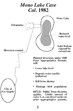
The Division of Water and Power granted Los Angeles the right to divert the water flowing from four of the five feeder streams to Mono Lake in 1941, and the city built equipment that channeled approximately half the flow (Abrams et al 543). In 1970 Los Angeles constructed another aqueduct and was then able to divert the entire flow of the feeder streams (Abrams et al 543). In 1980 National Geographic reporter Gordon Young investigated the situation to find a lake that had “dropped 18 inches annually” in the past few years, according to local expert Dean Taylor (504). John Melark, a limnologist, pointed out the lack of knowledge as to the speed of Mono Lake's changing ecosystem is due to the fact that in-depth research began only in 1976, meaning that there is really no history to compare today's conditions to (Young 511). At the time of Mr. Young's report, Los Angeles depended on the diversion of these streams for seventeen percent of its water (512).
The following diagrams show the “low points” of Mono Lake and the consequences of these low lake levels including exposed land bridges, pollution, and harm to the animals that depend on Mono Lake.
(Johnson)
(Hart 96)
Although the effects of the shrinking lake level have been vocalized by many, Duane Georgeson, the head engineer of the aqueduct project, pointed out to Young that it was only in 1967 that water flowing into Mono Lake was considered “a waste” by the California Department of Water Resources (514). Georgeson wondered at the time if it was fair to penalize the city of Los Angeles, which paid for the aqueduct system without federal assistance, because the water in Mono Lake is no longer considered a waste (514). Over the next three years an ecological controversy brewing in California eventually gave way to two monumental judicial decisions.
1983 Case
In 1983 the Mono Lake advocates and the Audubon Society got long-awaited news that the California Supreme Court had ruled Mono Lake to fall under the scope of public trust (Hart 101). Public trust applies to navigable waterways and protects them as a resource that should be available to all citizens (Abrams et al 546). The court realized, however, that it was not fair to deny Los Angeles the water that it had relied on for the past forty years (Hart 102). The court decided that the State Water Resources Control Board had the authority to declare the amount of water Los Angeles could take from the streams (Hart 102). At that news the Division of Water and Power took their case to the U. S. Supreme Court, which refused to hear it (Hart 102). It would be over ten years before a final solution was to come about.
1994 Water Board Decision
During the time between the assignment of the water problem by the California Supreme Court to the State Water Resources Control Board, a flurry of scientific research ensued with both sides making claims at levels the lake would need to be maintained at in order to be sustainable. Towards the end two numbers bounced back and forth: 6,405 feet and 6,390 feet. Finally the decision was made; the lake was to be sustained at 6,390 feet in order that the South Tufa remain on land and serve as an interpretation site (Hart 172). The number 6,390 feet is the level to which the lake must be restored by the Los Angeles Division of Water and Power to ensure a healthy ecosystem. During the time that the water level is rising, the Division may divert some water; but the goal is to make the stream flow to Mono Lake seem as natural as possible, which means allowing a large amount of water flow during the spring thaw ( http://www.monolake.org/restoration/orders.htm ).
The Future of Mono Lake
In an estimated twenty years, Mono Lake will have achieved its required level of 6,390 feet. Although this may seem like the end of rocky era, the damage done by the diversion of the streams will take much longer to repair. Riparian forests and stream ecosystems will slowly rebuild themselves over time as one of the country's oldest lakes continues to give birth to new life in the air, on the shores, and underwater. Mono Lake and the surrounding Mono Basin have only begun to impress upon humanity the amazing power of nature. The potential for the future of this area is bound only by the ever-moving earth it is sitting on.
WORKS CITED
Abrams, Robert H., et al. “Legal Control of Water Resources Cases and Materials.” Third Edition American Casebook Series. West Group St. Paul MN 2000.
Background Information Mono Lake California . http://www.wetmaap.org
Gaines, John and the Mono Lake Committee . Mono Lake Guidebook . Lee Vining, CA: Kutsavi Books, 1981.
Hart, John. Storm Over Mono: The Mono Lake Battle and the California Water Future . Berkeley, CA: University of California Press, 1996.
Johnson, Ralph. “The Public Trust Doctrine.” http://www.ecy.wa.gov/programs/sea/pubs/93-53/ptd.html
Long Valley Caldera and Mono-Inyo Craters Volcanic Field, California http://www.und.edu/instruct/mineral/303Calif/
Mohlenbrock, Robert H. “Mono Mania.” Natural History . Vol. 113, Issue 5. June 2004.
Mono Lake Committee website. http://www.monolake.org
National Academy of Science. The Mono Basin Ecosystem: Effects of Changing Lake Level . The National Academy of Science Press 1987. darwin.nap.edu/books/0309037778/html/R1.html
Strong-Aufenhauser, Lisa. “The Mono Lake Water War.” Earth. Vol. 4 Issue 5. October 1995.
Young, Gordon. “The Troubled Waters of Mono Lake .” National Geographic . October 1981.