Geology and Natural Heritage of the Long Valley Caldera
Development of Playa Lakes
with a focus on Death Valley
Hilary Glen
ABSTRACT
Playas are evaporated lakes found mainly in arid regions. Their formation depends on climate and location. Playa lakes can support a diverse ecology ranging from prairies to extreme deserts. Specifically in Death Valley, the playa is a salt flat and contains mostly sodium chloride. The salt and other minerals are precipitated at different rates depending on their solubility, creating concentric circles. The Death Valley salt flat was formed by the evaporation of a Holocene lake.
INTRODUCTION
Playa lakes are landforms found in many different climates, although most commonly in arid regions. They are areas of land that were once lakes, but due to many factors, the lakes evaporated, leaving a vast region of sediment and minerals. One factor that contributes to the desiccation of lakes is climate change. During the glacial period, the climate and precipitation levels were much different than today, especially in the Death Valley region. Even up until the end of the Pleistocene era, Death Valley contained water. As the temperature rose, the lake (Lake Manly) began to evaporate. The evidence of a sea in Death Valley, now dry and desolate, informs scientists about the history of the climate changes in the desert. One can also learn about the history of the playa region by looking at its sedimentation. By examining the layers in the floor of the playa, it is possible to determine when water was present. Also, one can find out if the water was moving, how fast it was moving, and where it came from. This is determined from the size, shape, and depth of each layer.
Aside from being a geologic history museum, the playa lake in Death Valley has been used as an economic resource. In 1873, borax was discovered in the valley. Mining began shortly after in the early 1880's. The 20-mule team was utilized in the valley to haul back and forth from the mines (Coffman, John Edwin, 1999). According to the Playa Lakes Joint Adventure (a society fighting to conserve playa lakes in six states), many of the playas in the Great Plains area are multi-million dollar resources ( http://www.pljv.org/whatare.html ).
This paper centers on the formation, habitat, and structure of playa lakes, with a focus on the Death Valley salt flat. It touches on the history of deserts and the Basin and Range Province of California as well as the different types of playas that exist.
PLAYA LAKES: WHAT ARE THEY?
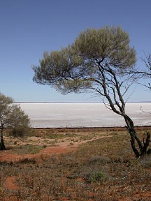
Figure 1. A playa lake. Photo taken of Lake Hart in South Australia. 2003.
Playa Lakes are dry lakebeds located in arid basins or valleys. In general, they form when water evaporates from a lake. As the water evaporates, it leaves behind minerals, which are called evaporites. Figure 1 shows a playa lake covered in white salt, an evaporite. Most playa lakes begin as endorheic lakes-which are lakes located in areas where they experience no output other than evaporation-and due to a climatic change they have completely evaporated (United Nations Environment Programme). Playa lakes can become ephemeral lakes (temporary lakes) when it rains, as playas will hold water until it evaporates. Although evaporation is responsible for most of the lake output, a small portion of water percolates (absorbes into the ground).
Playa lakes are found in arid to semi-arid regions because the average rate of evaporation is higher than that of precipitation, necessary climate for their formation. Playas also tend to be found in valleys where there is no other output, like streams, for the lake. In desert valleys, playas collect water from mountain runoff. With it, the water brings sediments from the mountain, including everything from large boulders to very fine silt. The larger rocks are left at the base of the mountain because when the water reaches the bottom of the mountain, its velocity greatly decreases and it no longer has the power to carry the larger rocks. Finer sediments, however, are carried further into the playa, creating layers. If the sediment layer has larger rocks in it, one can conclude that there was a heavier rainfall that year.
In general, playa lakes are shallow and flat on the bottom, and the floors tend to contain clay, which is fairly impermeable to water. They are typically less than one meter deep. The Death Valley salt flat is approximately 209 kilometers long and is 23 kilometers at its widest point (Coffman, John Edwin, 1999).
In the United States, two different kinds of playas (wet and dry) are found and both occur in deserts and prairies. According to the USGS article, “Hydrology of Playas and Genesis of Dust,” the distinction between wet and dry playas relates to the level of the water table beneath the surface. If the water table is closer to the surface, the playa is considered wet. Inversely, if the water table is far from the surface, the playa is labeled dry.
Although the same types of playas can be found in deserts as well as prairies, the location makes them very different. Desert playas, like that of the Death Valley Salt Flat, contain only microscopic vegetation and very little animal life (occasionally, waterfowl will stop if there is water). They may be surrounded with “salt-tolerant” plants like shadscale or saltbrush. In prairie playas, the ecosystem is very different. Some of the northern playas are comparable to wetlands as far as plant and animal life. For example, they might have cattail and bulrush. Generally, the prairie playas have different kinds of prairie grasses, ragweed, and are also used for farming (Haukos, David A. and Smith, Loren M., 1992).
ECOLOGY OF PRAIRIE AND DESERT PLAYAS
Prairie:
Playa Lakes in the southern high plains of Texas, New Mexico, Oklahoma, Kansas, and Colorado are ninety-nine percent privately owned. This means that they are heavily used for farming and irrigation. According to David Haukos and Loren Smith, the dominant crops range anywhere from cotton (southern) to grains (northern). These playas are also predominantly wetlands and house major wildlife habitats in their area (Haukos and Smith, 1992).
The average precipitation in prairie playas is drastically lower than the average evaporation. Average precipitation per year will range anywhere from thirty-three to forty-five centimeters, while the average evaporation per year ranges between 200 to 250 centimeters (Haukos and Smith, 1992).
In years of high precipitation, Haukos and Smith have recorded these playas to host up to three million birds including 115 different species. Most of these birds are waterfowl, including sandhill cranes, geese, and many different kinds of ducks. According to Haukos and Smith, the birds typically prefer the native vegetation rather than the agricultural grains grown in the playas. It has even been noticed that the birds have a higher survival rate in wet years because the native vegetation thrives. The native vegetation in playas that tend to get less precipitation is similar to that of upland vegetation. This includes plants like summer cypress, ragweed, and prairie grass. Playas that get more precipitation are more similar to the North American wetlands with plants like smartweeds, bulrush, cattail, and arrowhead (Haukos and Smith, 1992).
Deserts:
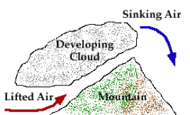
The most significant difference in the ecosystem of desert playas in California from the prairie playas is that there is much less precipitation. This difference causes different flora and fauna and faster evaporation, causing faster formation of the playas themselves. Precipitation in Death Valley is scarce because of the many mountain ranges separating it from the ocean. As the water travels from the ocean over the basin and range, much is lost. As the air rises over the mountains, it cools and water vapor condenses into clouds called orographic clouds. Orographic clouds are clouds that form as a result of topographic surroundings.
Figure 2: An example of an orographic cloud forming on a mountain. Photograph reproduced from “Lifting Due To Topography” from the University of Illinois at Urbana-Champaign
After the clouds form, precipitation falls over the mountain, usually in the form of snow. By the time it reaches Death Valley, there is very little left. According to the “Field Trip Guide to Death Valley National Park” developed by San Francisco State University, the average precipitation in Death Valley per year is between three and five centimeters and the average evaporation per year is about 381centimeters. In spite of the small amount of precipitation the desert supports approximately 1000 different species of plants and many animals as well (Desert USA). The plants and animals have adapted to the extreme temperature with unique water-saving mechanisms. For example, animals in the desert tend to be nocturnal as that is the time when the temperature is the coolest. Plants have a few different mechanisms, including very deep root systems to reach the water below the surface, and also very shallow roots systems that cover a large surface area. Above ground, plants have developed a waxy covering to their leaves and they only open their stomata at night. All of these methods prevent excessive evaporation.
Desert playas, more specifically salt flats, can support very little visible wildlife and vegetation, although they have an active microscopic ecosystem. In the PBS article, “Nature's Life in Death Valley,” scientist Dr. Susanne Douglas researches the microscopic environment of the valley (http://www.pbs.org/wnet/nature/deathvalley/print/mars.html ). Douglas finds that extremophiles, microscopic organisms, thrive in the valley. They actually grow better in the extreme heat of the summer, unlike any other organism. Algae are also found in the valley. The results of a study done in 1997 by research scientists show that these hypolithic algae grow mainly on translucent quartzite found in Death Valley (Anderson, Dale, et al, 1997). The translucent quality of the rock allows photosynthesis to take place, which in turn allows the algae to grow. According to the 1997 study, research scientists discovered that the hypolithic algae prefer the harsh setting of Death Valley because it has no predators.
On a larger scale, mesquite can be found along the edges of the salt flat, as it grows in saltier areas. Occasionally, as stated by Ranger Alan van Valkenberg, when there is water on the flat, ducks will stop to rest and eat. Unfortunately for the ducks, not only is there no food, the water is filled with salt and other minerals that attach to the duck. Eventually, the duck will become too heavy to fly and be stuck in the salt flats. The ducks inevitably meet an early demise (they are lovingly referred to as “salt ducks”), and the coyotes receive a nicely salted dinner (A. Valkenburg, pers. comm., 2006).
FORMATION OF DESERTS: DEATH VALLEY
Death Valley is located between the Panamint and Black mountain ranges in the Basin and Range Province of California. The Basin and Range Province is a region in which there are many parallel, north-south trending mountain ranges separated by valleys. This phenomenon occurred mainly due to the shearing of the North American plate against the Pacific plate (this shearing created the San Andreas Fault). The shearing of the plates stretched the earth's crust, forming basins (termed “grabens”), while the areas not as affected became mountains. Death Valley is a graben, which means that it is an area of land that has been dropped down due to faulting along the edges. The valley is also the result of uplift from the surrounding mountain ranges. Death Valley is actually a pool of sediment that has collected over that last million years. The original bedrock is approximately eight thousand feet below the current surface (A. Valkenburg, pers. comm., 2006). Scientists often say that rocks representing all eras of geologic history can be found in Death Valley (Hunt, Charles B., 1975). The only problem with the records is that they are jumbled, as the rocks have all been fractured, bent, metamorphosed, etc. due to shearing and faulting of the earth's crust (Hunt, Charles B., 1975).
Landforms:
Within the valley, not only does one find thousands of ancient rocks, one also finds landforms varying from sand dunes to salt flats. The sand dunes are well-sorted piles of silt formed from loose, fine sediment that is easily blown in the wind. In order for dunes to form, there must be a good deal of sand and a persistent wind. The moisture of the area/ground also determines if the dunes will form. Wetter areas are less likely to have dunes, as the sand is harder to move (Mountney, Nigel P., 2004).
Larger sediments may form alluvial fans, which are deposits from mountain runoff. Because the desert is so dry and because there is so little vegetation, the soil erodes very easily. When it rains, the water forms streams that rush down the mountains, and as it flows, the water picks up debris and carries big rocks down with it. At the base of the mountain, the water loses its velocity because the slope is greatly decreased. The contents of the stream are spewed out in a fan shape, creating an alluvial fan. Creosote bush can be found within the alluvial fan, as it is partial to the areas around the debris.
Another effect of the rain is the ephemeral stream or lake. These bodies of water are formed when the rain falls in the valley. It stays in the valley for a matter of days before it evaporates. According to “Field Trip Guide to Death Valley National Park,” the evaporation rate is so high that a 12-foot-deep, 30 miles long lake would take only one year to completely disappear (San Francisco State University, 2002).
The salt flat is a type of playa lake. In Death Valley, the salt flat was formed when Holocene lakes began to evaporate. Each time it has rained since, a new layer has been added. The flat is a vast area covered in salt that was deposited from evaporated water. When the water runs down the mountain, it dissolves minerals that precipitate out as the water evaporates. The result is approximately 200 square miles of leftover salt and other minerals (Hunt, Charles B., 1975).
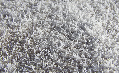
Figure 3: A close-up photograph of salt growths on the crust of a desert playa lake. Photo taken in February 2005 south of Badwater in Death Valley, California by John Fader
SALT FLATS
Formation and Chemistry:
A prevailing theory on how playa lakes form is stated by Haukos and Smith, and offers that they began as small indentations that expanded through hydrologic and geomorphic processes. As standing water percolates through the indentation, carbonic acid forms and dissolves the surrounding carbonate material called caliche (a substance almost like concrete that is made from sediment). As caliche dissolves, the ground falls away, making the indentation wider. The material that falls away fills in the bottom of the indentation, keeping it shallow and flat (Haukos and Smith, 1992). Since salt flats are a type of playa lakes, this theory is valid. However, a more likely theory for the salt flat in Death Valley is that it is the remains of a lake left by the glaciers. The reason behind this theory is that valley was already a lake bed, therefore making it flat. This would eliminate the need for expanding indentations. Also, the lack of precipitation causes lakes to evaporate very quickly, leaving a playa. In areas of greater precipitation, playas would rarely be able to form. Because the lake had no other outlet than evaporation, the minerals had no other place to go and were therefore left on the valley floor, creating a salt flat. Humans also contribute to the formation of playas. Due to human exploit, the water table has been lowered, reducing the overall moisture of the area. This results in the increased development of features like salt flats (Messina, Paula, et all, 2005).
Structure:
Salt flats appear to be random deposits of salt, however, there is a very complex structure within them. In Charles Hunt's book, Death Valley: Geology, Ecology, Archeology , the structure of the salt flat is discussed in detail. As the water evaporates, a brine is left (a soupy, salty muck) (Hunt, Charles B., 1975). The minerals in the brine all have different solubilities and therefore precipitate out at different rates and form concentric circles on the surface of the valley (Hunt, Charles B., 1975). The bottom-most circle is formed of calcium and magnesium carbonates (CaCO3 and MgCO3). Second, calcium and sodium sulfates (CaSO4 and Na2SO4) form around the carbonates. Next, if the brine contains an abundance of calcium, calcium sulfate (gypsum—CaSO4.H2O) is formed, if it contains a small amount of calcium, sulfate deposits called thenardite and sodium carbonate (Na2SO4 and Na2CO3) are precipitated. The most soluble minerals are the chlorides. Precipitating last, chlorides like table salt (NaCl) and small amounts of magnesium sulfate, potassium chlorides, magnesium, and calcium are deposited (Hunt, Charles B., 1975).
Although the solubility of the minerals is the primary determining factor in their precipitation, the environment also plays a part. The environmental influences included by Hunt are temperature, rate of evaporation, dissolved versus suspended material in the fluid, and how fast the fluid is moving (if at all) (Hunt, Charles B., 1975). The temperature, rate of evaporation, and rate of precipitation are all directly related in that the higher the temperature, the faster the rate of evaporation and the faster rate of precipitation. This will cause the flats to form sooner. This process further supports the alternate theory of salt flat formation. If a mineral is simply suspended in the water, rather than dissolved, it will not precipitate, but merely fall to the bottom of the flat as silt. Finally, the turbulence of the water plays a role in the rate of precipitation. If the water is moving, as opposed to a still body of water, the minerals will take longer to precipitate because the moving water promotes solution and keeps the minerals dissolved. This is one reason that playa rivers are not common.
The surface concentric circles were at one time symmetrical, but are now asymmetrical because of the shifting in the valley. The shifting resulted in an eastward tilt and caused the southern end of the valley to collide with the Black Mountains (Miller, Marli, 2005). The rings have also been disturbed by the addition of fresh water in the form of rains and floods. In his book, Charles Hunt states that the fresh water relocates the preexisting salt and forms its own smaller scale of concentric circles beginning with the deposition of rock salts in standing water. Around this pond, there exists a surface where smooth, silty rock salt lies. Further yet, a zone of springs yields massive amounts of gypsum that is surrounded by a sulfate caliche layer. The presence of the caliche within the carbonate zone implies that the water table was once much higher (Hunt, Charles B., 1975).
This concentric circle structure is further complicated with vertical layers that also reflect the solubility of the minerals. Instead of expanding out across the flat, demonstrating the solubility in the lake, these layers show the solubility related to the percolation or rising of surface/groundwater. As the surface water percolates, carbonates are deposited on the surface, with a layer of sulfates beneath, and chlorides on the bottom. Hunt concludes that the reverse is true with rising groundwater.
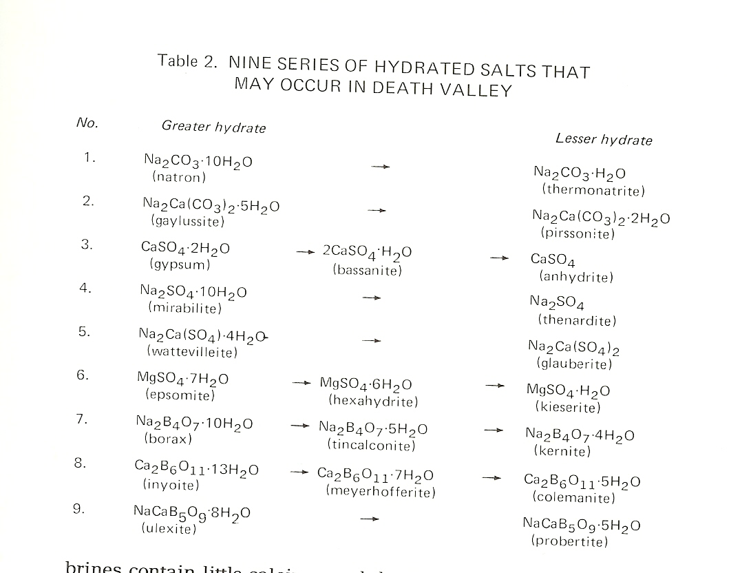
The next structural level is the zoning of degree of hydration. Hunt places the minerals in Death Valley either under the greater hydrate or lesser hydrate categories. Hunt displays them in Table 1.
Table 1: Figure Reproduced from Hunt, 1975.These titles label the mineral as one that has a high or low content of chemically combined water. The lesser hydrates, also called dehydrated minerals, primarily exist in areas where there is no flooding and where the ground temperature is high—basically where there is very little water. They also exist, however, in wetter areas where the salinity exceeds ten percent. In these wetter areas, there is an increased amount of sodium chloride, which is thought to dehydrate the minerals itself (Hunt 42).
Mineral Zones:
Hunt states that the broadest level of organization in the salt flats consists of three mineral zones: chloride, sulfate and carbonate. These zones divide the flat into areas of distinct geological features. The chloride zone is the biggest zone covering seventy-five percent of the valley floor. Within this zone, there are four facies, which are defined by the Merriam-Webster Online dictionary as “a part of a rock or group of rocks that differs from the whole formation (as in composition, age, or fossil content)” ( http://www.m-w.com/). They also extend out from a center point like the concentric circles. The centermost facies consists of massive rock salt that is between two to six feet thick and covers an area of seven square miles. This area is almost all pure rock salt. The next facies surrounds the first with rough, silty rock salt. This deposit is a result of an area that was ephemeral (occasionally contained water). Due to the intermittent rainfall, states Hunt, the mud and silt were integrated in with the salt. The prime example of this area is Devil's Golf Course (Hunt, Charles B., 1975). Outside of this area, the next facies is characterized by smooth, silty rock salt. This area is layered with finer silt, rock salt, and mud, and each layer reflects the frequency of rushing water. The layer of smoother silt is the result of more flooding at higher velocities, while the rougher surfaces are a sign of less. A recent area of flooding defines the last facies. This flood occurred in 1969 and eroded the salt crust (Hunt, Charles B., 1975).
In the sulfate zone, one can observe different types of mineralogy. According to Hunt, the different minerals are a result of specific kinds of brine that varies per location. The northern end has less calcium, but more sodium. This results in sodium, instead of the calcium, combining with carbonate, creating trona (Na3H(CO3)2.H2O). Sodium sulfate is also formed at the northern end (Na2SO4). Hunt found that the southern part of Death Valley holds much more calcium and therefore, one will find hydrous calcium sulfate, also known as gypsum (CaSO4.H2O). A characteristic feature of the sulfate zone, as noted by Hunt in his book, is the massive gypsum deposits. It is thought that the gypsum was formed from the sulfate marshes that are currently being fed by springs. In these marshes, “cauliflowerlike” sulfate statues grow and on the inside of these structures, small pieces of gypsum form (Hunt, Charles B., 1975).
The carbonate zone is located at the edge of the salt flat. Its contents are mostly silt and sand with small crystals of calcite that form within the sand. Though this zone is called the carbonate zone, the more abundant minerals are sulfate and chloride. These three zones are the final level of organization of the salt flats in Death Valley (Hunt, Charles B., 1975).
Morphology:
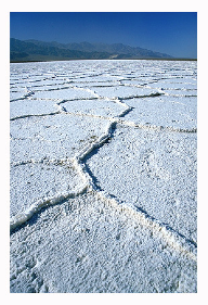
The floor of the salt flat in Death Valley is patterned. These patterns are generally polygonal in shape and are cracks in the salt. According to Charles Hunt, the cracks are thought to be formed by the same process that forms the cracks over a layer of ice: frost action (Hunt, Charles B., 1975). Frost action is the process of melting and freezing water. As the water melts, it works its way into tiny faults in the ice. When it freezes, the water expands and further separates the ice. The same process occurs in the salt flats, but instead of water freezing and melting, the salt is dissolving and re-crystallizing.
When the cracks form in the salt, they tend to be wedge shaped, with the widest part nearest to the surface and the smallest part deep in the ground. The wedges are widened with each dissolving and re-crystallizing of the salt. The level of moisture also contributes to the formation of the polygonal cracks. Cracks are dissolved in floods and then re-formed as the ground dries. Different areas of the desert have unique patterns as a result of the amount of wetness in the region. Another attribute of the wedges, noted by Hunt, is that they can grow upward (Hunt, Charles B., 1975). The salt in the wedges probably is able to grow because of capillary action of water and salt through the silt.
Figure 4: Salt flats in Death Valley: polygonal crack with upward growth. Photo taken by Gregory P. Logiodice. 2003
Salt structures are also formed as a result of the capillary action of salt water through the surrounding mud and silt. Hunt explains that the salt precipitates beneath an object like a stick and raises it up above the surface. The salt water can also travel up wooden poles and when the water evaporates, the salt bursts through causing a bulge in the pole.
Another interesting landform in the salt flats is the salt pools. Salt pools are also related to the polygonal shape but because of the water erosion, are more circular. These pools form as a result of the collapsing of salt and mud layers. According to Ranger Alan van Valkenberg, the pools used to be abundant where Devil's Golf Course is now located, but for reasons unknown, they have slowly dried up (A. Valkenburg, pers. comm., 2006).
CONCLUSION
Playa lakes have an important role in the environment as well as the classroom. Aside from the historical knowledge that can be gained from studying the formations in the playa, researchers are beginning to relate the conditions of the Death Valley playas to that on Mars. It appears that even the climatic and geologic history of the valley is similar to that on Mars and studies are now being done on the microscopic life in the salt flats in hopes that they may lead to finding similar life on Mars.
Playa lakes form as a result to many environmental conditions and landforms. They are very organized landmasses that have provided habitats for much wildlife and economic resources for humans.
Works Cited:
Books:
Coffman, John Edwin, 1999. “Death Valley” World Book Encyclopedia , vol.5, Chicago, World Book, Inc.
Hunt, Charles B., 1975, Death Valley: Geology, Ecology, Archeology , Berkeley, University of California Press, pp. 1-4, 36-66.
Websites/Web journals:
DesertUSA: The Ultimate Desert Resource, “Death Valley National Park,” http://www.desertusa.com
Hypolithic Algae at Johnson's Canyon: Death Valley Sample Collection of March 5-7 1997, Research Scientists: Dale Anderson, Dr. E. Imre Friedmann, Dr. Christopher P. McKay, Ragnhild Landheim: http://cmex.ihmc.us/ExtremeEnvironments/index.html
Merriam-Webster Online Dictionary: “facies” http://www.m-w.com/
Nature. Nature's life in Death Valley. 2006 Educational Broadcasting Corporation http://www.pbs.org/wnet/nature/deathvalley/print/mars.html
Playa Lakes Joint Venture. “What are Playa Lakes?” http://www.pljv.org/whatare.html
United Nations Environment Programme: Division of Technology, Industry and Economics. Newsletter and Technical Publications: Lakes and Reservoirs vol.2
The Watershed: Water from the Mountains into the Sea . Endorheic Lakes: Waterbodies That Don't Flow to the Sea” http://www.unep.or.jp/ietc/publications/short_series/lakereservoirs-2/10.asp
USGS Website—Effects of Climate Variability and Land use in American Drylands: Hydrology of Playas and the Genesis of Dust: http://esp.cr.usgs.gov/info/sw/alluvial/playas.html
Journals:
Haukos, David A. and Smith, Loren M., 1992, 13.3.7. Ecology of Playa Lakes, Waterfowl Management Handbook, pp 1-7.
Messina, Paula, Smith, Ward C, and Stoffer, Phil, “Macropolygon morphology, development, and classification on North Panamint and Eureka playas, Death Valley National Park CA,” Earth-Science Reviews, vol 73, pp309-322, 2005.
Miller, Marli Bryant, 2005, Geological landscapes of the Death Valley region, Earth-Science Reviews , vol. 73, pp 17-30.
Mountney, Nigel P., 2004, The sedimentary signature of deserts and their response to the environmental change, Geology Today , vol 20, p101-110.
San Francisco State University, “Field Trip Guide To Death Valley National Park,” 2002
Photographs:
Cloud Diagram: “Lifting Due To Topography,” University of Illinois at Urbana-Champaign. http://ww2010.atmos.uiuc.edu/(Gh)/guides/mtr/cld/dvlp/org.rxml
Death Valley Slat Flat with Polygonal Patterns: Landscape and Nature Photography by G.P. Logiodice http://www.gplphotography.com/
Playa in Lake Hart http://en.wikipedia.org/wiki/Playa
Close-up Photo of Salt http://en.wikipedia.org/wiki/Playa