Geology and Natural Heritage of the Long Valley Caldera
The Geology of the Mono Basin:
A Natural Time Capsule
Stephanie Estes
The finest workers in stone are not copper or steel tools, but the gentle touches of air and water working at their leisure with a liberal allowance of time.
-Henry David Thoreau
ABSTRACT
Tucked away amidst the authoritative Sierra Nevada Mountain Range, the relatively flat, yet dynamic area of the 50 km wide Mono Basin embodies characteristics that both relate, and distinguish this local from other places in the Basin and Range. Over time, this area has accumulated an extremely wide variety of geological formations, due to the different processes occurring throughout history, including volcanoes, craters, lakes and islands.
INTRODUCTION
Spanning from the ancient Mono Lake which still remains today, to a rather new chain of craters referred to as the Mono-Inyo Craters, the Mono Basin portrays the evolution of this area in a physical sense during very active and thus exciting times, including present day. Although this activity could possibly lead to a better view of the region's past and future, it could also make the Mono Basin a very hazardous area.
Volcanism, which is responsible for a vast amount of geological features in the Mono Basin area, could also be considered a hazard as well. One of the most profound aspects of the Mono Basin is how recent certain features have formed. For instance, Paoha Island located in Mono Lake to this day has hot springs below its surface, indicating possible future volcanic activity.
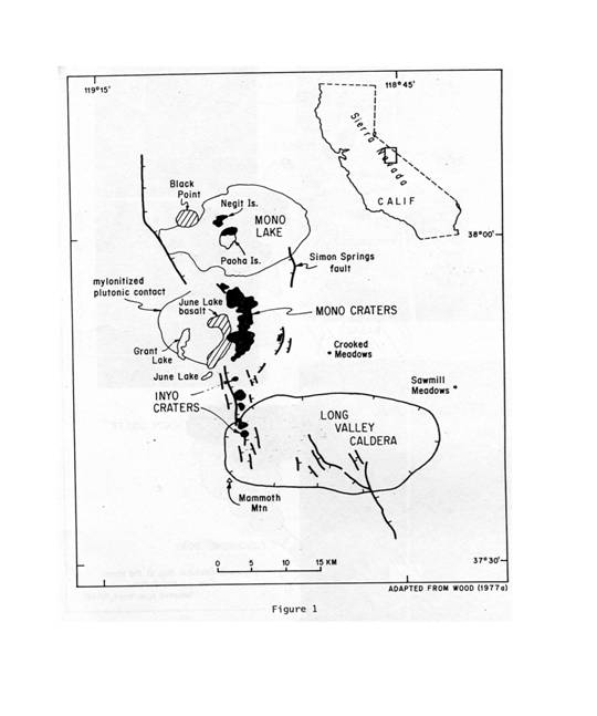
Figure 1 is a general map of the Mono Basin (Stine)
This, amongst several other places in the Mono Basin contribute to the area's awe-inspiring presence. Yet, what had to of occurred in the past in order for the Basin and Range as a whole to be here today, is quite amazing as well.
BASIN AND RANGE
With the Mono-Inyo Craters reaching as far as the Long Valley Caldera, and the Sierra Nevada Mountains framing its entire west side, the Mono Basin lies on the western edge of the Basin and Range. Compared to the towering peaks of the Sierra Nevada, sometimes reaching as high as 13,000 feet, the Mono Basin's “floor has been subsiding for the past 3 to 4 million years, dropping a total of 6,000 feet” (Tierney, 9). This is typical of the Basin and Range area as a whole, where “a series of parallel north-south trending mountain ranges with basins in between” dominate the landscape for miles and miles (Tierney, 30).
Tectonics
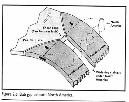
The reason for this reduction in the Basin's elevation, and existence for that matter, is due to the Tectonic activity of this area. Due to the sheering of the Pacific sea floor plate against the North American continental plate nearly 20mya, a “slab-gap” was created, which means “a zone in which no subducted sea floor slab stood between the continent and the mantle” (Tierney, 29). (Figure from Tierney).
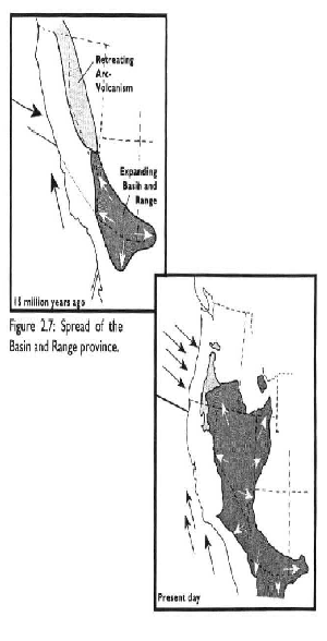
Figure 2.7 depicts the thinning and stretching, which created the Basin and Range, in the past and present. (Tierney)
Figure 2.6 depicts the formation of the “slab gap” in the Pacific Plate and the North American Plate. (Tierney)
Because of heat from beneath the earth's surface causing expansion, this somewhat fragile area has over time thinned and stretched, creating the Basin and Range. Combined with Sierra Nevada Mountains, Mono Basin earns the label of Basin and Range, with its beginnings as a result of this complicated Tectonic process.
WATER AND GLACIATION
Mono Lake
Considered “one of the oldest lakes in North America, Mono Lake is atleast 760,000 years old” and is one of the most unique aquatic features of the Basin and Range (Inyo National Forest, 11/97). Because of the Mono Basin's lower elevation compared to the mountain borders, it might be hard to believe that this lake at one time was large enough to overflow its rim. But in fact, Mono Lake's elevation, although approximately 6, 300 feet today, has fluctuated tremendously over the years. For instance, “Mono Lake has been accumulating a vast supply of salts and other chemicals since the last time it was high enough to overflow its basin some 60,000 years ago” according to Tierney, where “ice-aged climates once caused Mono Lake to swell over 800 feet above its modern level” (Tierney, 9). Furthermore, during these ice-ages, glaciers moved throughout the are and thus “every local lake west of Mono Kale owes its existence to glacial excavation of its basin (Tierney, 39).
Although it at first it appears to be just another large body a water, a closer look and more importantly, a closer taste will tell a different tale. Mono Lake is a terminal lake, meaning it only has tributaries leading into the waters, but none to flow out. Located at the bottom of the Sierra Nevada Mountains, Mono Lake has both rain and mountain melt to contribute. Yet, the only means by which it can rid of this water is through evaporation. Thus, after being evaporated the water leaves behind highly concentrated alkaline minerals, making the water almost bitter to the taste.
With this in mind, it may not be difficult to agree with an old quote from Mark Twain, which said the area was “…a lifeless, treeless, hideous desert …the loneliest spot on earth,” if one wasn't properly informed (Mono Lake-Long Valley Region, 49). In fact, this is one of the most productive lakes in North America, providing habitats and food for several different species of birds at an extremely high rate.
Tufa
An interesting feature within Mono Lake is the presence of Tufa Towers. These gray, and porous protrusions emerging from the lake and also the shore, are somewhat mystifying at first glance. To the touch, they crumble quite easily, but the formation as a whole is fairly firm. Tufa is rather rare, and can in fact only be found in a few other places, similar to the highly alkaline concentrated Mono Lake area.
Due to the fluctuating levels of the lake as mentioned above, some Tufa towers are no longer located in the actual lake. Yet, it can be inferred that these towers started in the water, since their formation is dependent on the contents of the lake. More specifically, “the strange spires and knobs are formed when fresh water springs containing calcium bubble up through the carbonate-rich lake water” and thus create the Tufa towers (INYO National Forest, 11/97). According to Dave Marquart our guide at Mono Lake, these springs are a result of faulting below the lake's surface, and thus where the Tufa towers have formed for nearly 800 years. Dave also mentioned that after these towers have separated from the water, they are no longer able to grow. Thus, it is important when visiting the area, to not damage the preexisting towers.
VOLCANISM
Paoha and Negit Island
Along with the Tufa towers, two islands, Paoha and Negit, can be found in Mono Lake. From a distance, although it is obvious that Paoha is the larger of the two, it can be seen that both islands have a summit which rises from the shoreline, upward to the center of the lake. Although the islands are above and surrounded by water today, due to lake levels varying, the shoreline of the two have most likely at some point been completely underwater and also connected to the lake's shoreline as well, when the water level is down.
Both islands have a dark layer of sediment and vegetation on its surface, where Paoha also has a lighter material as well. This lighter sediment on this island is there because “Paoha island is composed of lake sediments that were uplifted from the lake bottom, probably by intrusion of this later rhyolite dome” (Bailey, 4). Compared to other similar formations, this “uplift of the Paoha Island and extrusion of the associated rhyolite is younger still and may have occurred between A.D. 1720 and 1850;” only 200 years ago! (Bailey, 4)
These islands are apart of what is called the Mono-Inyo chain. This chain is an area of active vents which “started about 40,000 years ago and has continued almost to the present,” where on the “northern end of the chain, recently active vents include the cones forming Negit and Paoha Islands,” (Mono-Lake Valley Region, 51). As mentioned above, the formation of these islands has occurred within the last two centuries, which in terms of geological time, is not very long. Even more impressive, is the fact that these processes have been continually happening since their beginnings.
Black Point
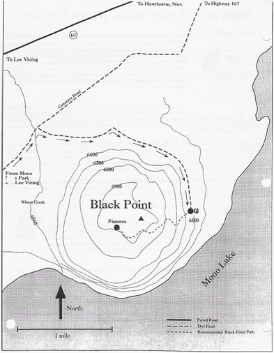
One example of early volcanism in the Mono Basin is Black Point. From Black Point, Mono Lake, its islands and Tufa towers can be seen clearly. Black point is what can be called a “false summit”, with multiple layers appearing to be the top, but like the Energizer Bunny, “it keeps going and going and going". As mentioned before, “Black Point is a volcano that erupted beneath the waters of a much deeper Mono Lake about 13,000 years ago, near the end of the last Ice Age” (Mono Basin Visitor's Center, 2/01).
From this diagram, the “false summit” can be seen with the multiple, gradual elevations. (Class Binder)
Although this volcano in particular is quite old, “recent studies indicate that the rate of eruptions has increased significantly during the last 10,000 years; the past 2,000 years have brought eruptions every 200 to 300 years” (The Mono Lake- Long Valley Region, 51.)
Panum Crater
Another example of these fairly recent eruptions is Panum Crater, located south of Mono Lake and Black Point. Although it is not absolute, the idea that these several volcanoes including Panum, are connected by mere locale is supported by the fact that the causes for these formations, or vents are on a north to south trend. “Actual Fissures and faults along which vents are aligned are evident only sporadically along the chain, they clearly parallel a pervasive north to northeast- trending fracture system…” (Bailey, 2).
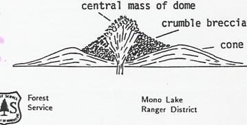
Panum Crater has a circular ring of unconsolidated sediment, known as a tephra ring, giving the area the appearance of an arena. Below the ring is a mote, where the ring slopes down a fairly steep gradient to the bottom of the crater, forming a relatively flat area at the bottom.
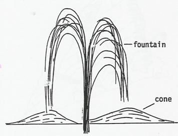
Inside the ring, is an inner pile of more unconsolidated sediment with rocks from gain size, to as big as houses. Granite can be found amongst this pile, along with obsidian as well. “This 600 year-old volcano exhibits all of the characteristics of the textbook rhyolitic, plug dome volcano…Products of this rhyolitic eruption are pumice, the rock that floats, and obsidian …” (INYO National Forest). To be more specific, a rhyolitic dome volcano is one in which there is an initial explosion that occurs as a result of rising magma from the earth's interior. As a result of this explosion, there is a very large depression which is form, accompanied by ash fall that in turn forms a ring around the depression.
The second part of this process is the filling of the crater, which is what can be seen at Panum. There is an effusive eruption, which is quite a bit less violent and causes more of an “oozing” of material rather than an actual explosion. Thus, the middle of the crater is filled by these flows, which often happen multiple times, in different areas of the crater. This variation in explosive eruptions, which causes quick , and slower cooling, results in a wide variety of rocks within this area, which is exactly what is found.
Diagram A: depicts the first phase of Panum Crater, in which an explosion caused a tephra ring to be formed.(Class Binder)
Diagram B: depicts the second phase of Panum Crater, when the center is filled with less explosive material. (Class Binder)
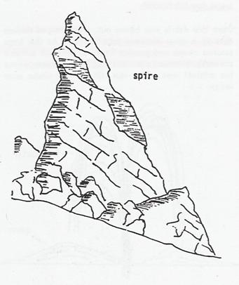
The extremely large rocks that seem to protrude from the crater's surface, forming into castle like shapes, on referred to as spires. These formations are a result of “lava pushed up through cracks of the hardening dome,” during the second phase of activity.
Figure C: of a spire, which can be found in the middle of Panum Crater. Some have fallen from their erect positions over the years. (Class Binder)
Although sometimes referred to as the “world's most adorable volcano” Panum Crater could possibly be the sight for a fairly violent explosion in the future. “Although Panum is in a dormant phase, another eruption could happen,” and furthermore “Geologists predict that one of the Mono Craters could erupt at any time in the near future” (INYO National Forest).
CONCLUSION
To stand atop an enormous pile of rocks, ranging from pebbles to car-sized, and realizing the processes which happened in order to create such a monument, is quite profound. Even more so, to think about the possibility of those activities happening at anytime, can be quite intimidating. Especially when one considers the time scale in which someone must think on in order to analyze geological history, the processes and products of the Mono Basin is remarkable.
Unfortunately, these recent events can also be considered dangerous as well. For those living in neighboring towns to the Mono Basin, such as Lee Vining, the possibility of a future eruption can mean difficult times. For instance, the effect that one eruption might have can take on a wide range of forms. Lava flow, and ash fall are just a few examples, and each pose great problems.
One must consider the lack of control there is over such an occurrence, when dealing with geological processes such as the volcanism of the Mono Basin. Proper precautions must be taken, and the environment must be respected.
Even when observing Paoha Island from the shore, one can see steam rising from vents on its surface. These are signs of not only future activity, but present activity as well. Although there is no absolute way in which one can predict the future, it is possible to analyze the past and apply it to the present.
The Mono Basin has on display countless products from processes of the past. It is pertinent to observe, and understand what is in the here and now, in order to realize the impact of the past on the present.
References
Bailey, Roy A., 1989, Quaternary Volcanism of Long Valley Caldera and Mono-Inyo
Crater, Eastern California. p. 1-36.
INYO National Forest, Panum Crater. (Class binder).
INYO National Forest, Mono Basin: National Forest Scenic Area. 11/97 (class binder)
Mono Basin Visitors Center, Seekers of the Black Point Fissures. p. 2/01.
The Mono Lake- Long Valley Region: California's Potentially Most Dangerous Volcanic Field. p. 46-56. (class binder)
Stine, Scott. et. al. Holocene Paleoclimatology and Tephrochonology East and West of the Central Sierran Crest, 1984. p. 21-59.
Tierney, Timothy, 1997, Geology of the Mono Basin. p. 7-56.
G190 Field Notebook
Class Lectures