Geology and Natural Heritage of the Long Valley Caldera
The Various Forms of Volcanic Structures of Long Valley
Sally Wood
Volcanoes are most notorious for causing death and destruction all over the world. As is common in movies volcanoes are portrayed as causing great destruction and show people fleeing for their lives. In contrast, much beauty is created in the landscape which is largely an ignored legacy. The media seldom tell of the children a volcano leaves behind. For the purposes of this paper, the children are being known as domes, craters, cones, tuff rings, stratovolcanoes and maars. My paper will give light to the processes from which they are formed. Then it will go into deeper detail as to where these are seen in the Long Valley Caldera of California.
Magma
All the structures in the paper are formed because of magma. So, here is a little introduction to magma. Magma is what lava is before rising to the surface. It is a combination of melted rock material, and gas. Magma has many elements that are found within in it such as iron, silicon, and oxygen is to name a few. The amounts of these that are found are varying from one area to another. An important element that is made up by two of these is silica it is a combination of oxygen and silicon. Silica makes up about 45-78 percent of the magma [Decker and Decker, 1997]. The amount of silica in magma determines the viscosity of magma. Viscosity is thickness, for example syrup has a high viscosity and water's is low.
Domes
Domes come in very different varieties. They can be short and smooth like the top of the Hoosier dome in Indianapolis or they can be very tall and rigid. There are four classification types of domes as recognized by Steve Blake; coulees, low domes, upheaved plugs and peleean domes [Francis and Oppenheimer, 1993]. Domes are formed after a volcano has erupted. A dome is a build up of lava flow or many series of different flows. The lava flows that create domes are very viscous and usually have not moved very far from the vent. Domes are made out many different types of rock but the most common seems to be dacite, andesite, and rhyolite. The growth rate of domes differs from each one and that growth can last from a few months to decades. For instance, in Guatemala there is still a dome, Santiaguito Dome, erupting that has been active since 1922 [http://volcanoes.usgs.gov/Products/Pglossary/LavaDome.html].
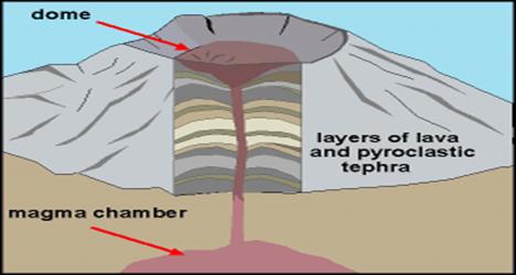
The diagram shows the cross-section of a dome. http://wapi.isu.edu/envgeo/EG6_volcano/volcanoes.htmOn the class trip, we visited two volcanic structures located in the Long Valley Caldera, Obsidian Dome and Panum Crater. These two were the most recent structures we saw and were approximately 600 hundred years old [http://volcanoes.usgs.gov/Products/Pglossary/LavaDome.html]. The structure types of both were very similar. They both had high concentrations of obsidian and much of it was laced with pumice. The biggest difference between the two is Panum had a ring around it and Obsidian Dome did not. The tops of both structures were filled with rigid rocks and sides. They were not smooth and in some areas, Panum Crater's obsidian was a much purer quality than that found at the Obsidian dome. Obsidian is formed when magma cools so quickly that it does not crystallize, forming volcanic glass. It is a very shiny, hard, and sharp black rock.
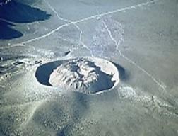
View of Panum Crater and lava dome toward the south
http://lvo.wr.usgs.gov/gallery/MonoCraters_1.htmlCinder and Scoria Cones
Cinder cones and Scoria cones are two names for the same material. Scoria is the type of material that makes up a Cinder cone. They look like an upside down ice cream cone with an end that has been chopped off. At the peak of a cinder cone there is usually a sized crater. The craters diameters average between 50 and 600m. The cones can range in height from 50-200 meters. The diameter of the base of a cone can range anywhere from .25m to 2.5 km, making the average volume approximately 4 x 10 7 m 3 [Schmincke, 2004] .However, the size of a cone is ultimately determined by the size of debris that is evicted from the vent. The time it takes them to form is very short when compared to most volcanic structures. Usually, a collapsed crater is first formed, then the cone shape fills in around it. Domes are formed from vicious lava that is expelled from a vent. The lava contains a lot of gas that causes it to be projected into the air, and as it falls back to the ground, it forms into small cinders. These cinders fall around the outside of the vent causing a ring and build up eventually to resemble a cone shape. The basal deposits are usually made up of lapilli. Highly xentholith enriched breccias overlay the basal deposits. Then these layers alternate stratifications with tuff layers. The first day of eruption is when the dome gains the most height reaching altitudes of up to 100 meters. Fifty percent of cones stop increasing in size after a month and 95 percent stop after a year [Schmincke, 2004].
http://pubs.usgs.gov/gip/volc/types.html
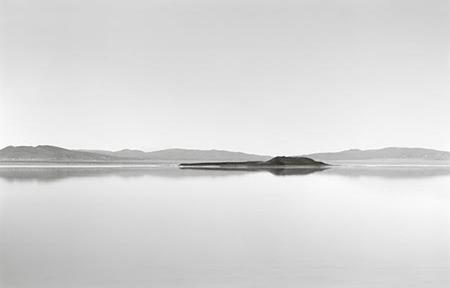
There are many cinder cones located in the Long Valley Caldera area. The one that I remember the most from the trip is Negit Island located in Mono Lake . Negit is a small black cinder cone. Its first eruption was approximately 1,600 years ago and the most recent eruption only took place about 270 years ago [http://vulcan.wr.usgs.gov/LivingWith/VolcanicPast/Places/volcanic_past_long_valley.html].
A picture taken by Tom Mallonee of Negit Island on Mono Lake .
http://www.anseladams.com/Negit-Island-Mono-Lake-by-TOM-MALLONE--P2052C324.aspx
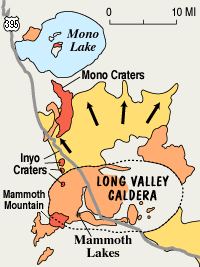
Map of the Long Valley Caldera area.
http://pubs.usgs.gov/dds/dds-81Caldera
Calderas can form in at least three different ways which are: cauldron subsidence, down-sag or trap- door. Many calderas show a mixture of these three types. Cauldron subsidence is where a large amount of magma leaves the top of the magma chamber unstable, causing it to collapse inwards [Francis and Oppenheimer, 1993]. Next is down-sag. This is where the upper crust slightly moves about the magma chamber. This type of caldera lacks main ring faults but it is possible for it to have fractures and crevasses surrounding it. The third type of trap-door is “where part of the subsiding block has remained hinged to the surrounding crust and has not foundered [Francis and Oppenheimer, 1993].”
The eruption that results in causing calderas is usually very violent and intense. The eruption dispenses large amounts of pumice and ash. These rocks ended up falling into the area which they filled forming the indentions in the earth known as calderas. The caldera can have varying diameter sizes anywhere from a few km to 60km [Fisher et al., 1998].
Many hydrothermal features can be found in calderas, such as hot springs and mud pots. These features all occur because in one way or another the magma below the surface is inter acting with the water table. Also, it is common to find signs of uplift and/or subsidence with in a caldera.
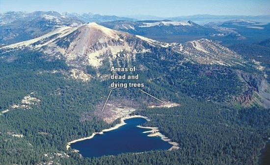
On the trip we encountered only one caldera. Our visit to the Long Valley Caldera was incredibly interesting. In fact, this caldera was my place of residence for 10 days. My relationship with the caldera is very close and we both hold fond memories of one another. It covers an area approximately 10 miles wide and 20 miles long [http://vulcan.wr.usgs.gov/Glossary/Caldera/description_caldera.html]. It is the first area located within the Basin and Range and to the west it is bordered by the Sierra Nevadas. This caldera was formed approximately 760,000 years ago [Francis and Oppenheimer, 1993]. There is still magma that lies beneath the caldera; this magma is the source of energy that heats the water. Because of this activity, geothermal plants have been built to provide energy to the surrounding areas. Another important effect to mention about the caldera is the tree kills. There is a high concentration in the soil that is on Mammoth Mountain . This is causing the tress to die off in the area, this type of location is often referred to as a tree kill. Right now this is not a threat to residents but in the future it could cause a problem. As of recent measurements at Mammoth Mountain the amount of CO 2 being released a day is approximately 300 tons [http://pubs.usgs.gov/fs/fs172-96/].
A picture of the tree kills area located on Mammoth Mountain . http://pubs.usgs.gov/fs/fs172-96The caldera also falls under the category of Volcanic Unrest. This is because of the earthquake activity that has been happening in recent years. This has also had some economic effects for the town of Mammoth Lakes. In May of 1980 after Mt. St. Helens erupted, this area was shook by four big quakes that all reached a magnitude of six [http://pubs.usgs.gov/fs/fs108-96/]. This unrest caused an uplift of a dome within the caldera. As of 2000, this uplift has continued and is now measured at about 2.5 feet. This is a result of magma rising below the surface. It was thought that the caldera might erupt soon so an emergency route was built. It is now known as the scenic route. Unfortunately, this caused the property prices to drop significantly. Mammoth Lakes has made a strong come since then and is now an expensive resort town to which many Californians flock on weekends.
Maars, Tuff Rings & Cones
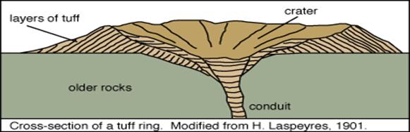
Tuff rings are a close relative to maars. One big distinction between the two is location. The tuff rings are built above the substrate whereas maars are built into the substrate. Tuff rings are made up of extremely fragmented basaltic scoria, also known as surtseyan tephra. Tuff rings are formed from “violent hydromagmatic eruptions with relatively high columns and eruption rates [Francis and Oppenheimer, 1993].” Tuff cones are made up of the same materials but they are quite a bit smaller and steeper. Whether the eruption results in a ring or cone depends on the amount of magma to water interaction. The length of eruption does hold some bearing as well. These eruptions tend to be less violent than those that form rings but the duration tends to be longer. These cones can commonly be mistaken for scoria cones. However, unlike scoria cones, tuff cones can have both outward and inward dips. Tuff cones commonly have layers of tephra surrounding the inner and outer slopes of the cone, as well as the rim. Maars are small craters with soft slopes. They are formed by small phreatic eruptions caused by water and magma interactions forming a crater in the earth. Many maars fill up with water which forms lakes or ponds and some are spring fed. They have low rims and fairly steep sides which erode quickly. Maars are small volcanic features with a diameter of approximately 1km [Francis and Oppenheimer, 1993]. It is not uncommon for one to confuse a maar as an impact crater.
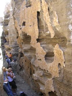
Black Point Fissure. Personal Collection of photosIn the Long Valley caldera I observed at least one tuff ring and many maars. I do not recall finding or observing any tuff cones. Black Point is also a young tuff ring. It is located at the north end of Mono Lake . Black Point was once located underneath Mono Lake . This is where its formation and erupting phases took place. However, due to the recession of Mono Lake , Black Point is now exposed. We were actually able to climb up Black Point and look around at all of its volcanic characteristics. There were several fissures located at Black Point that were thought to be cooling fissures. Some of the fissures go as far down as 80 feet and are as much as 4 to 5 feet wide [http://vulcan.wr.usgs.gov/LivingWith/VolcanicPast/Places/volcanic_past_long_valley.html]. Here, we also found the interesting walls with the mammillak like features. Also, there was a tephra ring was located around Panum Crater. It was like a hill that completed that circumference of the crater and created a moat like area between the two. The ring was half the height as the crater.
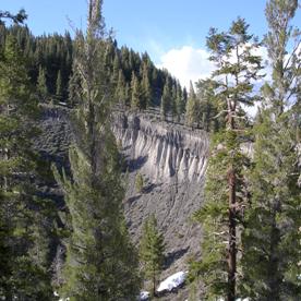
A picture of an Inyo crater showing signs of stratification.
From personal collection of photos .No large chunky rocks where on it and it looked to be mostly loose lapilli, a very sandy area. It had bushy vegetation growing on it and no trees. The maars that I remember most clearly are the Inyo Craters. They were fairly spherical and stratified which is clearly seen in the picture below of one of the Inyo Craters.
http://volcano.und.nodak.edu/vwdocs/volc_images/europe_west_asia/saudi_arabia/harrat.htm
Stratovolcanoes
Stratovolcanoes are the stereotypical volcanoes that are really tall and snow covered. These volcanoes take many years to form, the time spans usually from 100 to many thousands of years. They are built up of many layers of tephra, pyroclastic and lava flows [http://volcanoes.usgs.gov/Products/Pglossary/stratovolcano.html]. This is why sometimes they are referred to as composite volcanoes. These volcanoes erupt many different types of magma for example; rhyolite, basalt, dacite, and andesite [http://volcanoes.usgs.gov/Products/Pglossary/stratovolcano.html]. Basalt is the only one of these for types of magma that does not normally produce violent eruptions. Usually stratovolcanoes are not created from a single vent instead they are formed by vents. These vents are usually found within the crater that it located at the top of the volcano.
In the past 10,000 years 1,511 of the volcanoes that have erupted 699 have been stratovolcanoes [http://volcanoes.usgs.gov/Products/Pglossary/stratovolcano.html]. This includes the eruption of Mount St. Helens in May 18, 1980. In the cascades Mount St. Helens is the most active and youngest stratovolcano. Scientists have uncovered about 35 different layers of tephra, these layers date as far back as 3,500 years [http://volcanoes.usgs.gov/Products/Pglossary/stratovolcano.html]. According to Hamburger [2005 conversation] Mammoth Mountain located in Long Valley would be considered a Stratovolcano.
There are many more volcanic structures that exist; however, the ones that I discuss are the ones that are most relevant to the Long Valley Caldera area. They all are completely different except that, like the others, are formed by volcanic explosions. Some of their differences are their types of rocks and shapes. The magma is still causing new things to happen and form within the Long Valley Caldera. If the Magma decides to come out, at that point it can be studied for amount of silica it contains or maybe what dome shape it has formed. Whatever the case may be the landscape that it will form, will be of great beauty and provides endless fascination.
References
Decker, Robert and Decker, Barbara. Volcanoes .New York: W.H. Freeman and Company,1997
Francis, Peter and Oppenheimer, Clive. Volcanoes . New York : Oxford University Press Inc., 1993
Fisher et al. Volcanoes Crucibles Of Change . Princeton , NJ : Princeton University Press.1998
Schmincke, Hans-Ulrich. Volcanism.New York:Springer. 2004
Environmental Geology. June 16, 2005. http://wapi.isu.edu/envgeo/EG6_volcano/volcanoes.htm
Photo glossary of volcano terms-Stratovolcano. 04-Sep-2000. U.S. Geological Survey, June 16,2005. http://volcanoes.usgs.gov/Products/Pglossary/stratovolcano.html
Photo glossary of volcano terms-Volcanic Dome. 31-Mar-2003 . U.S. Geological Survey. June 16,2005. http://volcanoes.usgs.gov/Products/Pglossary/LavaDome.html
Photos of the Mono Craters, California . 9 October 1999. U.S. Geological Survey, June 16,2005. http://lvo.wr.usgs.gov/gallery/MonoCraters_1.html
Principal Types of Volcanoes. 2/6/97. U.S. Geological Survey, June 16,2005. http://pubs.usgs.gov/gip/volc/types.html
America 's Volcanic Past - Long Valley Vicinity, California . 11/9/01. U.S. Geological Survey, June 16,2005. http://vulcan.wr.usgs.gov/LivingWith/VolcanicPast/Places/volcanic_past_long_valley.html
The Ansel Adams Gallery. June 16, 2005. http://www.anseladams.com/Negit-Island-Mono-Lake-by-TOM-MALLONE--P2052C324.aspx
The Long Valley Caldera GIS Database. U.S. Geological Survey. June 16,2005. http://pubs.usgs.gov/dds/dds-81
Calderas and Caldera Formation. 4/3/03. U.S. Geological Survey, June 16, 2005. http://vulcan.wr.usgs.gov/Glossary/Caldera/description_caldera.html
Invisible CO 2 Gas Killing Trees at Mammoth Mountain , California . 10/14/04. U.S. Geological Survey, June 16,2005. http://pubs.usgs.gov/fs/fs172-96/
Living With a Restless Caldera— Long Valley , California . 10/14/04. U.S. Geological Survey, June 16, 2005. http://pubs.usgs.gov/fs/fs108-96/
Harrat Hutaymah , Saudi Arabia . June 16, 2005. http://volcano.und.nodak.edu/vwdocs/volc_images/europe_west_asia/saudi_arabia/harrat.html