Geology and Natural Heritage of the Long Valley Caldera
Meteoric Water in Hydrothermal Systems
Isaac Simonelli
Meteoric water is the main source of water in a magmatic hydrothermal system. The water is derived from rainwater, rivers, lakes, glaciers, snow and ground water. The water moves through a groundwater system then becomes heated as it approaches the magma chamber or source of heat. The heating process causes it to rise, thus completing the hydrothermal cycle. As the heated water moves through the system it leaches minerals from the rocks it moves through and deposits them elsewhere. The process of leaching the rocks of minerals and chemically changing their composition is called hydrothermal alteration. The process of depositing the minerals is known as mineralization.Both hydrothermal alteration and mineralization are found in hydrothermal systems. The definition of a hydrothermal system according to Franco Pirjno (1939) is a “distribution of hot fluids circulating, laterally and vertically at various temperatures and pressures below the Earth's surface.” These systems can be found all over the world in many different types of places including volcanic areas. An excellent example of such a place is the Long Valley Caldera and the surrounding areas. This volcanically active area exhibits many internal and external features of an active hydrothermal system based on meteoric water. In this essay I will be looking more closely at groundwater cycles moving into hydrothermal systems. I will briefly discus hydrothermal alteration and mineralization. I will also cite examples of and realte these processes to the Long Valley Caldera in California .
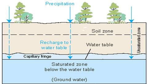
Ground water is the top surface of a water table. Below this plane the ground is saturated with water, making it an aquifer or large storehouse of water. Above the ground water is an unsaturated area known as a capillary fringe. [USGS] The capillary fringe, though unsaturated contains water that is in immediate contact with the water table. Above this is an unsaturated, zone that has a constant flux in the amount of water it contains. [Basic Ground Water Hydrology] It is interesting to note that approximately thirty percent of all the freshwater in the world is in ground water. (USGS) An active groundwater system requires two main points, recharge areas and discharge areas. Recharge areas are where new water enters the system. The factors that impact the efficiency of a recharge area are permeable bedrock, fractures, and precipitation.
Precipitation and other incoming water to the system is the limiting factor of a groundwater system. Even when there is plenty of water, if it enters the system too fast, it is unable to soak into the ground and will run off in the form of rivers and creeks. When there is not enough water either it is unable to soak in deep enough to reach the water table or it evaporates before it has a chance to. This poses a major problem on the East side of the Sierra Nevada Mountain range because very little water is able to traverse the mountains in the form of rain, leaving most areas with less then ten inches of rainfall per year. These areas instead rely on glacier and snow melts from the high Sierra. In the winter snow builds up in the mountains on the west side of the Long Valley Caldera.In the late spring the snow melts and moves down the mountains and seeps into the groundwater system.
The above diagram was created by USGS. It depicts the system tha the water int a recharge area moves through before it becomes part of the saturated water table.
Gravity and topography help with controlling water flow, and in this case guides it toward the Caldera. The permeability of bed rock and fracturing within a system also controls the amount of water that is able to reach the groundwater system. Rock permeability or the ability of water to seep through rock is very important. Many dense un-vascular rocks don't allow water to move through them quickly causing it to run off- much the same problem as when there is too much precipitation. The water is unable to find an easy path to the water table. Volcanic rocks tend to be very vascular and have a high permeability, which allows easy access to the water table. The Long
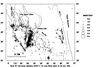
Valley Caldera is mostly composed of volcanic rock. There are some sedimentary layers of rock that have accumulated between various volcanic eruptions. These layers are mostly seen over the layer of Bishop Tuff inside the caldera. This is because of the caldera's role as a lake bed for during the ice age. The other key element to the permeability of bed rock is fracturing. Fractures and faults present natural ways for water to move down toward a discharge point with as little resistance as possible. These faults and fractures can range in size from major faults to hydrothermal fractures. Hydrothermal fractures are created from the heating and cooling of water. As water cools or freezes it expands, fracturing the rock around it. It then melts, leaving behind a larger gap which is filled with new water. This processes continuous, eventually making large fractures in the bedrock. The largest faults come mainly from seismic activity. Earthquakes often create faults by fracturing the surface and dropping it down or moving it horizontally. The Long Valley Caldera is continually exposed to seismic activity, as can be seen from the diagram below
The dots and circles represent earthquakes of different magnitude in 1989. It should be noted that seismic activity in the caldera has decreased since 1999. Even with this decrease there are still many earthquakes every year, allowing more and more paths for water to travel through. [USGS]
The“goal” of water in a ground water system is to reach a discharge point and thus continue in its cycle (The Water Cycle). In the cases we are interested in, this water moves into a hydrothermal system, particularly a volcanic one. The actual discharge of the ground water does not occur in a hydrothermal system until the water has been heated up and reacts within the system. When it finally does rise it comes out in the form of hot springs , fumaroles, mud pots, geysers or mofettes. Some of these end products can be found in the Long Valley Caldera. Mud pots are prevalent in the area surrounding Casa Diablo (a geothermal plant). There are also fumaroles and hot springs present in the Caldera. The most well known of the hot springs is Hot Creek, which accounts for approximately eighty percent of total discharge in the Caldera. [Answers.com (geothermal areas in Long Valley )] As the water travels away from the recharge point it begins to warm up. In fact, the heat flow ( the amount of heat moving through the ground and water) increases. This is true in all ground water systems. Water at recharge points almost always has a lower heat flow than at the recharge point. General global heat flow ranges from 40 to 70 mW/m2. This can be completely different at the recharge and discharge points. Recharge points can be isothermal or even negative, while at discharge points temperature is limited only by the boiling point depth curve. Heat flow, which is in three dimensions, can be calculated with Fourier's Law that states that heat flow is the product of the temperature and a coefficient known as thermal conductivity. This can be represented by the equation qh = - Km ?T, where qh is heat flow, km is thermal conductivity and T is temperature. Km is judged on the porosity of the bedrock. Most heat flow will be seen in a vertical dimension. [Ingebritsen and Sanford, 1998]
All hydrothermal systems require two things: water and heat. The heat in the systems we are interested in comes from magma intrusions. Most high temperature (greater then 150° C) hydrothermal systems are created from these magmatic intrusions.
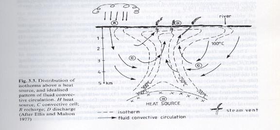
This diagram, taken from Pirajno's book, Hydrothermal Mineral Deposits, clearly shows the way in which cool water moves in on the sides of the hydrothermal system. Then as they are heated it moves up to the discharge point. In the cases we are discussing the heat source (H) represents a magmatic intrusion.
When these intrusions are inner continental they are usually composedof an intermediate to silica magma. The reason for this is that these magmas are less dense, more viscous, and have a lower melting point. All these qualities allow it to accumulate closer to the surface (approximatly10 km in depth.) When the heat source is closer to the surface it allows it to interact with the water table more efficiency. Though it was once thought that the magma chambers actually contributed rocks and minerals to the hydrothermal system, it is now hypothesized that it merely acts as a heat source. [Ingebritsen and Sanford, 1998] The amount of heat produced by a magma chamber depends on its latent heat of crystallization and degree of cooling. The area between the water table and magma chamber is referred to as conductive boundary layer. It might be expected that as heat is transferred from the magma chamber its edges begin to cool and crystallize inward causing a retreat of the magma chamber. [Inebritsen and Sanford, 1998] However, if the amount of magma being created within the chamber is greater than the crystallization it is possible in theory to have ground deformation or a resurgent dome. The resurgent dome in Long Valley is a wonderful example of an actively growing dome. Since 1980 it has been uplifted over 70cm. The Resurgent Dome, though, has an abnormally cool temperature in comparison to other areas with in the Caldera. This was discovered when the Long Valley Exploratory Well (LVEW) drilled 2200m down into the resurgent dome in 1991. They went even deeper in 1998, going all the way down to 3000m still the results where abnormally cool. At 3000m it was nearly isothermal. It is theorized that the dome has cooled down from past hydrothermal activity and is not part of the newer hydrothermal system of the caldera. Another explanation is that the topography of the resurgent dome forces cold water down into the system cooling it off. [Pribnow and Schutze 2003]
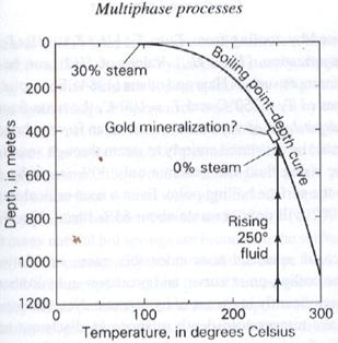
Usually, water enters a hydrothermal system from the edges, moving down to the point that it starts to expand from heat and then rising up through the center of the system. Before it rises it is able to heat up to a much greater temperature than is possible at the surface due to the increase in pressure, making it super heated water. The super heated water rises almost isothermically until it meets the boiling point curve. The boiling point-depth curve represents the temperature at which water boils at specific depths. This curve can change with the presence of salts and non-condensable gases. After rising water hits the depth curve it will continually boil as it rises, thus following the curve until it reaches the surface.
Water, however, cannot entirely be converted to steam through an adiabatic process. In fact, the rising liquid can only convert approximately 30 percent of itself into steam by decompressing and cooling to the surface boiling point. It then leaves the system by way of a discharge area. [Ingebritsen and Sanford]
T his Boiling point-depth curve is for pure water at Yellowstone National Park . It gives a hypothetical trajectory of a rising hydrothermal fluid. [Ingebristen and Sanford]
A hydrothermal system discharges both gases and liquids onto the surface. The gases can be steam or other gases that have come out of solution as the water rises. These gasses are able to come out of solution because as the water rises, pressure is decreased.
Hydrothermal systems have three different types of water discharges: carbonate-rich, acid sulfate, and alkaline-chloride. The carbonate-rich water is created as water moves through limestone or dolomite. When the water reaches the surface it loses its CO 2 causing it to condense. The water in Mono Lake already filled with carbonate rich waters, perhaps from a past hydrothermal system, mixes with calcium-rich waters to create the famous Tuffas. Acid-sulfate waters for the most part have low discharge rates, creating mud pots and small pools. The reason these waters are particularly acidic has to do with the oxidation of H 2 S to H 2 SO 4 . These are usually created from the condensation of steam above the water table. Alkaline-chloride, on the other hand, is mostly liquid water that has worked its way up through the ground. This water is rich in Na, K SO 4 , HCO 3 and CO 3 , all of which are easily dissolved into un-pressurized water. [Hydrothermal Veins and Alterations] and [Bardintzeff and McBirney,2000]
Hydrothermal alteration is a major effect of a hydrothermal system. Essentially, is where the rocks that the super heated hydrothermal fluids flow through are physically and chemically altered. These alterations are caused by the water leaching out certain minerals and rearranging the minerals that are left behind. The leaching of these materials often changes the color to yellows, oranges, reds, whites, and greens. When a rock has turned green from alteration it has usually gone through the processes known as propylitic alteration. [Hydrothermal Veins and Alterations] There are many different types of alteration, each dealing with certain characteristics of the rocks after the hydrothermal fluid moves through them. (Curtis Williams) Hydrothermal fluids heavy with minerals and metals move along fractures and faults. As they move toward the surface the pressure on the water is decreased, thus bringing minerals out of solution. When minerals fall out of solution it is known as mineralization. (Hydrothermal Veins and Alteration) One of the first substances to fall out of solution is gold. It has been suggested that gold is deposited at the point where the water first meets the boiling point-depth curve. [Ingeritsen and Sanford, 1998] Mineral and metal veins are often found in ancient hydrothermal systems. What has happened to these systems is that the fractures or faults the hydrothermal fluid was passing through became filled up with mineral deposits, thus forcing the water to find other routes. These veins have high concentrations of the specific material at which they are made. Often, these areas contain enough material to be economically mined. There are several examples of mines within the Long Valley Caldera. There is still an active kaoline mine there; also there are several deserted gold mines. Just on the outskirts of Long Valley lay the ghost town of Bodie, which was at one point one of the largest gold and silver mines in the west. [Simonelli, personal observation] The reasons behind the large amount of mineral deposits within and around the Long Valley have to do with both recent and ancient hydrothermal systems that have had an abundance of faults and fractures to move through. The importance of the permeability of both a groundwater system and a hydrothermal system cannot be emphasized enough. It is the key factor in allowing water to move easily to the water table and then move easily to a discharge point after leaching and depositing minerals in the hydrothermal system. The Long Valley Caldera is a fascinating example of a diverse and active hydrothermal system.
Bibliography
Ingebritsen, Steven and Sanford, Ward
Groundwater in Geologic Processes
Cambridge University Press, 1998
Pages: 181-188, 199, 200Bardintzeff, Jacques-Marie and McBirney, Alexander
Volcanology second edition
Jones and Bartlett Publishers, 2000
Pages: 213-218Pribnow, Daniel; Schutze, Claudia and others
Journal of Volcanology and Geathermal Research 127
(2003) 329 – 345
Fluid flow in the resurgent dome of Long Valley
Caldera: implications from thermal data and deep
electrical sounding.
Pages: Abstract and introductionHydrothermal Veins and Alteration
http://wwwdmtcalaska.org/course_dev/explogeo/class08/notes08.html\
Washington State , Department of Ecology, Ground Water
Resource Protection Handbook
Published 1986
Chapter 2
http://wwwissaquah.org/COMORG/gwac/Hydro.htmUSGS:
Review of Long Valley Caldera Activity for 1999
http://lvo.wr.usgs.gov/Annual/lvc_99.htmlThe Water cycle: Ground water discharge
http://ga.water.usgs.gov/edu/watercyclegwdischarge.html
Piranjo, Franco
Hydrothermal Mineral Deposits
Library of Congress Cataloging-in-Publications Data 1939
Pages: 45-56
www.http://answer.com Search (Geothermal areas in Long Valley)