Geology and Natural Heritage of the Long Valley Caldera
The Sierra Nevada Batholiths
Ryan Swaffar
Exposures of intrusive rock, greater than 100km2, are called batholiths. The intrusive rocks mentioned are igneous in nature and are primarily phaneritic in texture, coarser grained, due to it being intrusive. In actuality, batholiths are just large plutons; masses of intrusive igneous rock from crystallized magma bodies (solid rock), or possibly a number of plutons that came together in its ductile, or molten, stage. Understanding if this is true is not easy because it is hard to find the actual depths of batholiths. A rough estimate can be found by using gravity measurements and by the use of seismic studies. Batholiths form in mountain belts and can only be exposed through numerous sequences of uplift and erosion; thus they form simultaneously within mountain ranges. (Earth's Dynamic Systems)
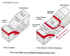
The formation of the Sierra Nevada Mountains can explain the massive exposures of batholiths. During the Jurassic era, 150 million years ago, an island arc collided with the West coast of the North American plate and created a set of mountains and metamorphic rock. At about the same time, a subduction zone occurred along the edge of the continent. This was a result of the oceanic plate, Pacific, colliding with the North American plate. The Pacific plate subducted because it was older, colder, and denser than the younger and less dense North American plate. As the oceanic plate subducted and reached a certain depth of melting, or melting point, magma from such rose towards the surface; the magma was less dense than the surrounding rock. As the magma rose, it created plutons, of a granitic nature, which were located deep beneath the surface. These plutons formed at various ages; from 115 million to 87 million years ago. By around 65 million years ago, the Sierras were merely rolling hills approximately a few thousand feet high. Around 25 million years ago, the Sierras began to rise and then tilt towards the west. (TheFreeDictionary.com)
This uplift and westward tilting is related to the Late Cenozoic extension and deformation affect the Basin and Range province. Granitic Cobbles of conglomerate, at the base of the Minarets sequence, show that plutons of granite were exposed as early as 100 million years ago. Around Eocene time, erosion produced the low topographic relief visible today in interfluvial upland surfaces (Bateman 106). Later in the Eocene period, 40 million years ago, the San Joaquin River drained a large area to the east and flowed across the Sierra Nevada region. As said, about 25 million years ago, the resulted tilting and uplifting began, but two thirds of it took place the last 10 million years. Prior, the tilt did not exceed .03mm and year but has actually exceeded such recently. Due to studies by Crough and Thompson(1977) and Mavko and Thompson(1983), the uplift took place during the Cenozoic era. This is found out to be related to the high heat flow and conversion of upper-mantle lithosphere to lower density asthenosphere. Thus the subducting slab of eclogite (which is a metamorphic rock consisting of garnet and pyroxene) shields the Sierra Nevada from the high asthenospheric heat flow that is affecting the Basin and Range province but allows the upper-mantle lithosphere beneath the Sierra Nevada to be converted to lower density asthenosphere, causing uplift in the Sierra Nevada. (Bateman)
This can also explain certain heat generations and flows throughout the batholith. It is known that the heat increases eastward, near the Sierran Crest. This is also due to the eclogite slab that shields the batholith from the heat derived from the mantle. The slab ends at the Basin and Range where it is evident that the upwelling heat is apparent in the area (due to the uplift and tectonic extension). The upwelling of warmer material replaces that of material moving horizontally in the extending layer which then preserves the isostatic equilibrium (much like buoyancy in a liquid, it is determined on the depth to the mantle, the density of the mantle compared to the density of the mass above, and the resistance to the surrounding material to flex and brittle failure along the boundaries of the region). (Bateman)
Continuing on, because of the tilting, rivers ran and cut into the mountains creating deep canyons. Then, around 2.5 million years ago, the ice ages began as the climate cooled and glaciers formed resulting in U-Shaped valleys, cirques, etc... The combination of the glaciers and the river systems had an extreme impact on erosion and, thus, exposed the plutons yet leaving a trace amount of metamorphic material overlying in some areas. This grotesque amount of exposed plutons became today's batholith.(TheFreeDictionary.com)
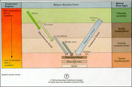
The batholith of the Sierra Nevada is very comprehensive in composition, size, and age. The begin with, its composition, as said before, is not classified as granite but as granitic rock or as other names like granodiorite, quartz monzonite, trondjhemite, and others. This is because of the volatiles, such as silica content, gas content (CO2 and the like), and amount of heat present. For example, more heat could lead to a longer state of cooling thus creating larger crystals; coarser grained, and the opposite can happen with less heat. Also, more silica could result in rhyolitic granite and less would be basaltic granite; there are numerous combinations. If you would take a closer look at the granite you could notice quartz, mica, feldspar, amphibole, pyroxene and more, depending on where it is. Where it is can have a definite impact on composition due to its surroundings, such as what dominant element is in the zone of diffusion (where the magma builds up at) thus possibly altering the composition of the original magma; again, numerous combinations. In the Sierra, it is a theoretical deduction (made by laboratory and field conclusions), that the plutonic rocks were formed within a liquid. This is the possibility: The liquid itself is hot and thick perhaps like mush and crystals continue to form until there is no more liquid, either because it is suddenly chilled to rock or totally crystallized. (Hill 65). By using experiments, geologists have found the minerals succession of crystallization from its hot liquid form. Those minerals which take longer to melt require more heat thus taking shorter amounts of time to crystallize, and vice versa. Therefore, darker colored minerals (those with high calcium, iron, and magnesium) form first and melt last. The orders in which the minerals, in such cases, crystallize are much the same; the darker, low silica minerals (if any silica) form first and the lighter, high silica minerals form last; this is otherwise known as Bowens Reaction Series (Figure 1). Mary Hill says As the minerals form, they tend to settle toward the bottom of the liquid, if it undisturbed. The reason is that the earliest minerals to form are also the heaviest heavier than the liquid itself. The next mineral in order is lighter in weight that the first (usually in color, too), but still heavier than the liquid. It, too, sinks, making a layer on top of the heavier, darker ones already at the bottom. (Hill 67). Because of this succession, in theory, the darker grey ones (heavier; like peridotite) should be overlapped by the intermediate grey ones (lighter; like gabbro and diorite), and those
should be overlapped by the lighter grey (lightest in weight; like granite). Because granite is last to form (therefore coarse-grained); it is composed of more sodium and potassium, it is made up of quartz and feldspar. The only catch in the batholith here is that granite is not necessarily recalled as such; because of the rich amounts of sodium and calcium-rich feldspar (and the below average amount of potassium), the technical area of rocks of this nature would fall into would be either granodiorite or quartz monzonite. This process, where magma crystallizes, is referred to as magmatic differentiation. Certain factors and affect the outcome of rocks: composition of the liquid (magma), movement that takes place within the magma (stirring and sloshing), and the melting of the earth around the liquid mass. Others include the contact with components as the magma reaches the surface (what it gathers up in its route to escape), and the dissolved gases in certain liquids can affect both the chemistry and the physical nature (mass, course of crystallization). (Geology of the Sierra Nevada)When speaking of location, the Sierra Nevada Mountains (Batholith) is about 400 miles long; extending from Tehachapi Pass in the south towards to Mount Lassen in the north, and is around 50-80 miles wide. It is composed of the highest peak in the continental US (Mt. Whitney at 14,494), has one of the youngest volcanic chains in the country (Mono-Inyo Craters), has the southernmost active glacier in the US (Palisade Glacier), and is composed of one of the oldest bodies of water in North America (Mono Lake). (MammothMountain)
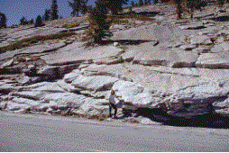
Some landforms of the batholith include that of the domes in Yosemite. Here, the joints of the granitic rock are parallel to the earth's surface. This is a result of sheeting, or the leafing away of layers. The rocks deep in the earth are under great pressure. When that rock reaches the surface, through erosion or uplift, that pressure is removed and the confined rock expands. During the expanding, large fractures (joints) are formed. (Earth's Dynamic Systems) Another name for such a case is called exfoliation. Another way to describe how this occurs could be a result of when the sun heats and expands the rock, then, during cooler seasons, it contracts (frost-wedging), and the split begins.But this theory is not all logical due to the fact that, through experiments, it had very little effect on granite. But, if the combination of heating and cooling occurred, such would happen: feldspar minerals, when water is added, form clay, which not only crumbles away when dry but swells when wet, shouldering other minerals aside. (Hill 74). Another fact would be that feldspar crystals are not equal in length in all 3 directions but instead are longer in one direction than the other two. This could help adjust the direction of sheeting (above: example of sheeting/exfoliation). (Geology of the Sierra Nevada)
The metamorphic rock, mentioned before, which occurred primarily before the uplift of the granitic batholith; today's dominant Sierra Mountains. A prominent metamorphic feature would be the roof pendants. These formed as a result of downward projection of metamorphic rock into the granitic rock (Igneous Intrusion). These are found as a result of an erosional remnant of metamorphosed material introduced by an igneous intrusion, in this case granite (or granitic rock). It is metamorphosed by the intrusion of igneous rock due to heat and pressure. In short, the batholith intruded older volcanic and sedimentary rocks that have been metamorphosed at greenshist to amphibolite facies conditions. These rocks of the Sierra Nevada batholith, account for 10 percent of the area, where they occur as roof pendants. (US Geological Survey 1799)
Multiple mineral products are also associated with the Sierra Nevada Batholith. Copper for example is located in the western to the southeastern portions of the Sierra Nevada. Deposits are found in the southwest corner, west of the Melones fault zone. Another popularly mined mineral is gold. Gold, in the Sierra, is formed primarily due to hydrothermal activity. Gold forms in high temperature hydrothermal quartz veins. These veins carry the gold to the earth's surface through super heated solutions and are eventually deposited in fissures to form ore bodies. Erosion of the host rock by wind and water (by both mechanical and physical weathering) washes away the gold from the ore bodies. Thus, gold is transported downstream where they are found, called placers, and then those that find the gold follow it upstream to its source, called lode gold. A previous locality of gold would be in Bodie of the Sierra Nevada. As mentioned, a lode is the source of gold. In the past, gold was mined along the Mother Lode; a 1 to 6km wide system of en echelon quartz veins and mineralized rock that follows the Melones fault zone. The past production was from quartz veins by recently it has been of interest in mineralized country rock. One can find these country rock sources by finding irregularities in a specific rock compared to the surrounding rock (e.g. color).
The gold in country rock is finely disseminated in altered greenstone and schist. Mineralized greenstone is known as gray ore and consists of ferromagnesian carbonates and lesser amounts of sericite, albite, quartz, pyrite, and arsenopyrite; it is interlaced with veinlets of quartz, carbonate, and albite, says Bateman (107). He continues on about how schist's composition is primarily ferromagnesian carbonate and subordinate sericite, quartz, albite, and pyrite. The exact age of the Mother Lode veins is very controversial but with Isotopic dating (from northwest Marisopa, to western areas like the Alleghany district) the age of the Mother Lode is from the Late Jurassic-Early Cretaceous plutons. This is possibly related to when, 150 million years ago (Jurassic Era), the island arc collided with the westward North American plate. (US Geo Survey 1483)
In conclusion, the Sierra Nevada Batholith is complicated in nature, literally. The stages and processes it came by to become what it is today is still not completely understood and possibly never exactly will due to variety of makeshift natural wonders of mother nature (e.g. weathering of all sorts[fire, wind, water, ice] and multiple tectonic possibilities[seismic activity, volcanic processes, etc...]). Though it seems to be impossible to fully understand, due to scientific evolution and great geologists (like James Hutton, Sir Charles Lyell, Alfred Lothar Wegener, Michael Hamburger, and John Rupp), we can actually find out what is happening and what has happened.
Works Cited
Hamblin, W. Kenneth and Christiansen, Eric H., 10th Ed., Earth's Dynamic Systems. Provo, Utah. 2004. 80-113 252-253 596-631
Bateman, Paul C. et al. Plutonism in the Central Park of the Sierra Nevada Batholith, California U.S. Geological Survey Professional Paper 1483. United States Government Printing Office, Washington: 1992. 1-177
Hill, Mary. Geology of the Sierra Nevada. University of California Press. Berkeley, Los Angeles, London: 1975. 64-79
Du Bray, Edward A. and Dellinger, David A. et al. Potassium-Argon Ages for Plutons in the Eastern and Southern Sierra Nevada Batholith, California U.S. Geological Survey Bulletin 1799. United States Government Printing Office, Washington: 1988. 1-5
TheFreeDictionary.com. Encyclopedia of Sierra Nevada. Copyright 2004. http://encyclopedia.thefreedictionary.com/Sierra%20Nevada%20%28USA%29
Mammoth Mountain Environment. Eastern Sierra Geology. Copyright 2002. http://www.mammothmountain.com/company_info/environment/pdf/Tmpl_geology4.pdf