Geology and Natural Heritage of the Long Valley Caldera
Mono Basin Volcanism
Renee Murdock
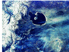
The last basin in the Basin and Range before the Sierra Nevada Mountain range is the Mono Basin. The Mono Basin consists of landforms such as the Mono-Inyo Craters, Black Point, Negit Island, Paoha Island, Mono Lake, Devils Punch Bowl, Panum Crater, and some others (Hamburger et al; 2004). All of these landforms were created by volcanism. Actually, the Mono Basin is in one of the most volcanically active places in the world (Forest Service; 2004). Paoha Island, Negit Island, and Panum Crater are the most recent volcanoes to erupt, which are the furthest north in the basin. The volcanoes' ages tend to get older the further south they are from Panum Crater; with the exception of Paoha. Eruptions in the Mono Basin have tended to occur in five hundred year intervals over the past two thousand to three thousand years (Molossia; 2004). Hot springs and fumeroles and other signs show that this area is still active (USDA; 97). Though there has not been any volcanic eruptions in the last six hundred years, there is still evidence of volcanic unrest in the Mono Basin area. (The Picture above compliments of USGS).
The Mono Craters were all formed within the last forty thousand years. These craters are localized on a north-trending fissure system that starts at the south of Mammoth Mountain up through the western moat to the north shore of Mono Lake; this system extends about fifty kilometers (USGS;2004). There are thirty domes that formed together (Molossia;2004). They were originally formed by the intrusion of a dike. About six hundred years ago when the magma began rising in the southern end of the Mono-Inyo Craters there was a series of eruptions and ground cracking. The dike was spreading both horizontally and vertically; it matured to eleven kilometers long and ten meters wide in some places. The first notable volcanic activity was from a chain of explosive eruptions at three separate vents. The explosions ejected pyroclastic and ground material that created craters. The explosion also created a pyroclastic flow that traveled six kilometers. After these explosions there were smaller phreatic explosions that created the Inyo Craters(USGS;2004).
There are three large craters and two of them are lake filled now. The two craters with lakes are the North and South Craters; which are over one hundred eighty four meters deep. The other crater, which is at the summit of Deer Mountain is about forty-six meters deep. There are nine smaller craters and five volcanic domes included in the Inyo Crater chain (Molossia;2004). (Picture above compliments of Molossia).
After the explosions that formed the Inyo Craters, eruptions started beneath South Deadman Flow. At the South Deadman vent, there were two events where ash and pumice fragments were expelled. Along Deadman Creek there is a pyroclastic flow deposit of about ten meters thick; this was formed by the explosion after the Inyo episode. Before long there was some volcanic activity at the Obsidian vent and Glass Creek vent. When the magma reached the surface at the Obsidian vent there was an explosive eruption that expelled ash and pumice fragments shot high into the atmosphere. After the ash and pumice stopped spewing from the vent, high silica rhyolite seeped out onto the ground. The gas in the magma was released before it had a chance to build up into an explosive violent release of gas, which is why it seeped out. With the combination of high silica and already released gas, the lava formed many thick mounds. Now, both Glass Creek and Obsidian Dome, look like large obsidian rock piles; with interesting rock fragments that looks like bread crust. These volcanoes are in Long Valley Caldera, though they erupted post- caldera, and it is quite possible that they will erupt again, though they are thought to be effusive eruptions again (USGS:2004).
Panum Crater is the northern most volcano of the Mono Craters and the most recent one to erupt. This landform was not created all at once, but in four phases. About six hundred and forty years ago when the magma was rising towards the surface, it heated up the water just below the surface. When the water turned into steam it caused an explosion, otherwise known as a phreatic blast. Following this blast, ash and pumice shot up and as they fell back to earth it formed a pumice ring around the original crater. After this the magma rose to the surface to form a series of domes. The lava was very viscous rhyolite that hardened over the vent very fast to form obsidian. As the magma still tried to push it's way through to the surface it broke the hardened lava and formed new domes. The broken pieces, called breccia, formed large piles. After a final dome was formed, the thick lava squeezed through cracks in the dome to form large spires. Most of these spires collapsed and broke (Molossia; 2004). This crater is famous for being a textbook example of a rhyolitic plug-dome (Topinka; 2001). The entire Mono Crater chain is a series of plug-domes (Monolake;2004). According to the United States Department of Agriculture Forest Service, an eruption is predicted to happen anytime in the near future, but that there will be plenty of warning signs before such would occur (USDA; 2004). (Picture above compliments of Molossia).
Paoha, one of the islands in the Mono Lake, is the youngest formation in the Mono Basin (USDA; 97). This is not a cinder cone like that of Negit Island, but is actually lake sediment from the bottom of Mono Lake. About two hundred and fifty years ago when magma moved up towards the surface, the bottom of Mono Lake upwelled; but it did not fully erupt. There have been a few small lava flows on the north end of the island, but it still has never fully erupted. The fumeroles and steam vents are indications that there is still volcanic activity in the area (Topinka; 2001). (Picture compliments of USGS).
Negit, the smaller black island in Mono Lake, is a cinder cone volcano. It first erupted about seventeen hundred years ago, but it last flowed about two hundred and seventy years ago. The eruptions were effusive, with hardly any ash or pyroclastic material. Basaltic lava is what flowed from this vent, which is what makes up the island now. Future eruptions are predicted here, but they are predicted to be effusive basaltic eruptions (Molossia;2004).
When Mono Lake was much deeper about thirteen thousand years ago, there was an eruption under its waters. The eruption was effusive, with basaltic lava. This eruption created what is now known as Black Point . The large, black hill has a flat top from the weight of all the water that over it from Mono Lake. One thing quite beautiful at Black Point is these large fissures. These fissures are look like large breaks in the land. These breaks can be as wide as four-five feet wide and eighty feet deep. These fissures' origins have been debated over, but are widely agreed that they were formed when the lava was cooling under the deep, cold waters of Mono Lake (Topinka;2001).
Further north of Mono Lake, where the presents of volcanism made many people very rich, is the Bodie volcanic area. Across a span of eighty square kilometers there is a volcanic field that dates from fifteen to eight million years ago. There is evidence of andesite and ash flow tuffs. Over these old volcanoes are some younger andesitic volcanoes that range from four and a half million years to two million years ago. Bodie hills have a basalt layer over the earlier andesite. The gold and silver can be found in the quart veins in the earlier levels of volcanic rocks, but not the latter. This volcanic area has been dormant for a very long time, and it is not predicted that this area will have an eruption any time soon (Wood:2002). (Picture compliments of USGS).
Mammoth Mountain is a very popular ski area; it is also an active volcano. Mammoth Mountain is located at the south end of the Mono-Inyo Craters chain. It is just outside of Long Valley Caldera; it is a composite volcano that is three thousand three hundred eighty nine meters high. The mountain was formed by a series of eruptions that began about two hundred thousand years ago and lasted until about fifty thousand years ago. The mountain is made of mostly rhyolite, which has been altered by some hydrothermal activity. The mountain shows many signs of volcanic activity. On the south side of the mountain by Horseshoe Lake, there is an area where trees have died from carbon dioxide saturation. This carbon dioxide is attributed to the magma that is below. This area is very dangerous, in the eighty's it showed increasing signs of volcanic unrest (Molossia;2004).
One of the most spectacular parts of the Mono Basin is Devil's Postpile. Devil's Postpile originated when basalt lava erupted in the valley of the Middle Fork of the San Joaquin River. Through radiometric dating of the rocks this area was formed less than one hundred thousand years ago. Columnar basalt is the formation that makes this place incredibly interesting. This formation of basalt is formed at the basaltic lava cools. It shrinks and cracks and forms vertical columns. The homogenous lava cools at a uniform rate, ranging from three to seven sides. These look like long post-like columns. There hasn't been any volcanic activity since these eruptions long ago. There are other areas in the world were lava has cooled in this same way, Giant's causeway in Ireland and Fingal's Cave in Scotland (Devil's Postpile;2004). (Pictue of Devil's Postpile is compliments of Devil's Postpile).
The Mono Basin is in one of the most geologically active areas in the United States, and the world. From millions of years ago to two hundred years ago there has been volcanic unrest in this area. Mammoth Mountain reigns a very popular area for tourists though it is quite the site for future volcanic activity. The Mono Basin is about forty kilometers long, with over thirty craters and domes. The Mono Craters are one of the youngest mountain ranges in North America. Specifically the Mono Crater's oldest peak is only forty thousand years old, and the youngest is Panum Crater that is six hundred and forty years old (Topinka:2001). (Picture below compliments of USGS).
Sources
Molossian Institute of Volcanology. Long Valley Caldera. 2004
http://www.molossia.org.org/volcanology/longvalley.htmlTopinka, Lyn. Mono-Inyo Craters. Last updated 11/09/01.
http://vulcan.wr.usgs.gov/livingwith/volcanicpast/places/volcanic_past_long_valey.html.U.S. Department of Agriculture. Mono Basin. National Forest Scenic Area. Inyo National Forest. 11/97.
U.S Geological Survey. Long Valley Observatory Website. Mono Lake Area, California. 2004. http://lvo.wr.usgs.gov/Inyoeruptions/inyoflows.html http://lvo.wr.usgs.gov/history.html
Wood and Kienle, 1990, Volcanoes of North America: United States and Canada:
Cambridge University Press, 354p.,p.256-262.
http://vulcan.wr.usgs.gov/volcanoes/nevada/description_nevada.html