Geology and Natural Heritage of the Long Valley Caldera
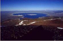
Mono Lake
Emily Avers
1. Mono LakeMono Lake is a unique body of water lying in the Eastern Sierra Nevadas. For decades its water sources were tapped by the Los Angeles Department of Water and Power (DWP) to use for farming because the lake's high elevation would allow them to easily transport the water to the city and because the water was so saline, people believed it was worthless. The normal traits by which people judge lakes were lacking in Mono: fish could not survive in the salty water, the water was harsh to swim in because of the chemicals and salinity, the scenery was unlike other lakes because there were no trees. Mono Lake appeared to be an isolated lake in the middle of the desert, which DWP could use as they wished. What they hadn't known at the time was the rich history of the lake and the important place it held in the biological world. The geological history of the Western United States has shaped Mono and given it the properties it has, while those properties have given it a specific role in the migration of birds.
Plate Tectonics
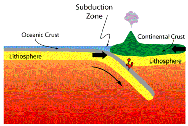
The geological processes that formed and continue to influence Mono Lake began approximately 215 million years ago when the Farallon sea floor plate began subducting, or pushing, under the North American plate. The North American plate was pushed over the sea floor plate by the force of the African and South American plates rifting apart. The friction from the North American plate rubbing against the Farallon plate melted some of the continental rocks, which then erupted in a long volcano chain, the Sierran Arc, stretching from Alaska to Mexico inland from the coast. Over time, the unerupted magma chambers from the Sierran Arc cooled into the granitic batholith that is the Sierra Nevadas (Tierney, 26-27).
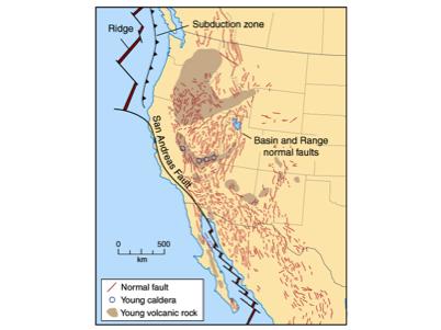
2. Diagram of Subduction ZoneAbout 20 million years ago the last part of the Farallon sea floor plate subducted under the North American plate. This put the North American plate and the Pacific plate into contact, but unlike the Farallon sea floor plate, the Pacific plate sheared against the side of the North American plate. Because there was no plate subducting, the North American plate was in direct contact with the mantle (Tierney, 29). Heat from the mantle made the continental crust more ductile, which allowed the crust to extend and thin. The thinning of the plate caused some thicker areas of crust to tip into thinner areas where there was less support, which caused the Basin and Range region of uplifting mountain ranges and down tipping valleys that extends from Idaho and Utah to California and Oregon. Over long periods, the basins are filled with silt and sediments until the land is flat. The Mono Basin and the Sierra Nevadas are the westernmost-- and youngest-- basin and range, respectively, and have been actively sinking and rising for 3 to 4 million years. During this period, the Sierra Nevadas have risen 4000 feet and the Mono Basin has lowered 6000 feet. The Sierra crest is currently 7000 feet above Mono Lake (Tierney, 32).
3. Diagram of Basin and RangeVolcanism
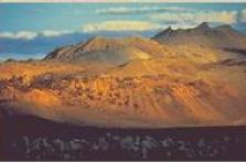
There have been many volcanic chains along the Sierra Nevadas, and even around Mono Lake. The oldest volcanoes created the Bodie hills, which are to the north of the basin. These volcanoes were among the last periods of activity of the Sierran arc in the Sierra Nevada area, although volcanism caused by the arc continues in the northern end of the western coast (Tierney, 44).
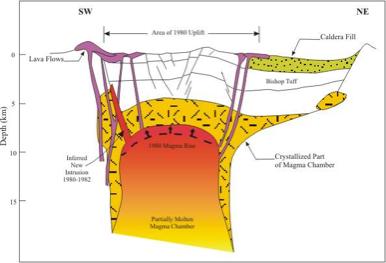
The second wave of volcanoes was caused by the Basin and Range activity. The thinning of the crust allowed magma to work up from the mantle. The beginning activity of this chain did not create many visible landforms, although some of the newer Bodie hills were formed during this time as well as Mount Hicks to the north of Mono Lake (Tierney, 45). Some basalt from this period has been found with the fossils of freshwater fish, which indicates that there was a freshwater lake in the area at the time, although it was not in the same place as Mono (Tierney, 46). One of the most important events of this chain was the Long Valley eruption, a cataclysmic eruption that was fed by an underground magma chamber (Tierney, 46). The magma chamber began forming when basalt from the mantle collected near the surface. The heat from the magma melted other rocks in the crust. As the chamber grew a number of small eruptions occurred to release the excess energy, but these small eruptions could not release enough of the energy from the growing magma chamber and eventually the entire chamber erupted, releasing 150 cubic miles of ash into the air and through the countryside in the form of a nue�Le ardente, or cloud of ash. This ash cooled into rock called tuff, and there is a thick layer of it in the bottom of Mono Lake (www.monolake.org). The area where the chamber was, collapsed and created the bowl shaped Long Valley Caldera. The eruption of the magma chamber was not the end of volcanic activity in the Long Valley area, however. There is currently a resurgent dome that is attributed to a growing magma chamber within the caldera.
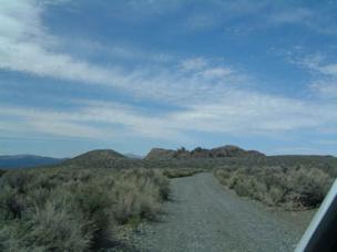
4. Diagram of Magma Chamber in Long Valley CalderaSometime around 100,000 years ago, volcanic activity in the Mono basin area began. It is believed this activity is caused by a magma chamber similar to the Long Valley chamber. The Mono Craters are the site of most of the volcanic activity. They are connected with the Inyo Craters in the south and together are the youngest volcanic chains on the continent. If one were to look at the volcanic activity in the Long Valley and Mono Basin area, one would notice that the volcanic eruptions form a line running from north to south. This line of activity is along a fracture where a granitic magma chamber rose to the surface of the Sierran arc. That activity stopped at the same time the Mono Craters became active, although the craters could have possibly been active as early as 100,000 years ago. If the earlier date is true, the features of the oldest eruptions would be buried under the more recent eruptions (Tierney, 49-51).
5. Mono CratersThe explosions in the Mono Craters were mostly granitic eruptions, although there were some phreatic explosions. An excellent example of a granitic eruption is Panum Crater, a volcano that erupted 630 years ago (Tierney, 50). The outer ring of Panum Crater is a debris ring, which was caused by the ash that was blown into the air by the force of the explosion. Within the debris ring is a crater, called the explosion pit. After the initial blast, the lava is extruded. The great viscosity of the magma makes it almost solid and, because it is unable to flow, it plugs up the vent. If the lava keeps flowing, it eventually overflows the debris ring and forms a coulee, or lava flow.
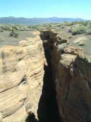
6. Panum CraterThere are several volcanic landforms close to Mono Lake. The oldest, Black Point, erupted underwater 13,300 years ago, during a glaciation when Mono Lake was 800 feet higher than it is currently. This caused the strange, flat-topped volcanic landform and the deep fissures. The fissures are covered with tufa in some places, which indicates that the fissures were formed while the volcano was still underwater. Like many of the volcanic landforms in the Mono Basin region, the fissures, Paoha and Negit islands, and even the ore deposits at Bodie all run in the same direction (Tierney, 53). These similarities in orientation are because the Mono Basin is at the center of two intersecting fault lines (Tierney, 54). The interaction between the faults causes fissures in the crust where magma and hydrothermal water can easily travel, causing the volcanic islands and the ore deposits.
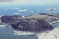
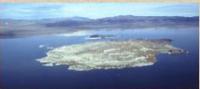
7. Black Point FissuresNegit and Paoha islands are also volcanic. They are the youngest volcanic features in the Mono Basin area. Negit, which means blue-winged goose, was formed 1,600 years ago by an andesitic eruption, which caused the dark color. It has remained active and most recently erupted 270 years ago. Paoha was caused by an upwelling of an unerupted magma chamber. The island is white because it is covered in sediments from the lake's bottom. It was formed 310 years ago and has many signs of volcanic activity including steam vents and hot springs erupting boiling hot water and mud. This event was possibly formed by a volcano (Tierney, 54). In 1890, there was volcanic activity once again in Mono Lake. Clouds of gases rose from the lake and springs bega similar to Negit, that remains under the surface of the water (Hill, 116).
8. Negit Island
9. Paoha IslandThere are many indications that the Mono-Inyo Chain is more likely to erupt than the Long Valley magma chamber. The fact that they have experienced a great amount of recent activity suggests that the area is more likely to undergo an eruption.
Climate
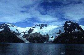
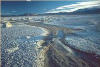
In the ancient history of the Mono Basin, rainfall was common. The Sierra Nevadas were at the end of a plateau and rain fell equally across it. With the start of the rifting of the Basin and Range region, however, the Sierras rose and created a water curtain; most clouds were not high enough to not pass over the mountaintops without raining, thus rising, on the western side (Hart, 8). The rain curtain makes the Eastern Sierras deserts because of the low amount of rain. The eastern part of the range shows many of the landforms associated with deserts, including terminal lakes. Mono Lake is an example of a terminal lake because all the water from snowmelt drains from the mountains and collects in the lake. Because the lake it relies on run-off for its water the lake level fluctuates drastically from year to year and during glaciations. There have been five glaciations in the history of the Mono Basin: The Tioga glaciation 11,000-21,000 years ago, the Tenaya glaciation 24,000-30,000 years ago, the Tahoe glaciation 60,000-75,000 years ago, the Mono Basin glaciation 90,000-120,000 years ago and the Sherwin glaciation 730,000-900,000 years ago (Tierney, 39). During the Tioga glaciation Mono could have been as high as 7,060 feet, which is over 800 feet higher than the current elevation (Hart, 12). The water overflowed the Basin and drained through the Aurora and Adobe Valleys before draining into Death Valley (Tierney, 42). The glaciers in the Mono Basin were among the few that extended past the mountains. These glaciers left 800 foot tall piles of debris that they took down the mountains with them (Hill, 136).
10. Glaciers in Alaska. These glaciers are similar to the ones that were in the Sierras during the glaciations.It was at the same time the area was stretching and thinning that Mono became an isolated basin. There are fossils from before the rifting began of fish fossils, which suggest that the lake was a freshwater lake before the basin, which trapped the water, was formed (Tierney, 9).
Most terminal lakes periodically dry up because of low snowfall years, but Mono has never experienced this. The reason is that Mono is situated under a weather gap, a low crest, which in some places is as low as 9,000 feet. The gaps near Mono are the ancient riverbeds of the San Joaquin River, which had to cut many paths as the mountains moved. The weather gap is low enough that clouds can pass over the mountain without releasing the water on the other side (Tierney, 10). The snow on the Sierran (western) side of the Basin can amount to 45 inches, while on the eastern side it can be less than five inches. This high amount of precipitation feeds the five streams--Mill, Lee Vining, Rush, Parker, and Walker-- that run into Mono Lake (www.monolake.org). During the past 900,000 years, when Mono was close to its present size, the lake level has fluctuated 130 vertical feet (Tierney, 14). Up to four vertical feet can evaporate off the surface of Mono Lake every year. The streams are necessary to help refill the lake, or it would completely evaporate (www.monolake.org).
Salinity
Mono Lake is salty because, unlike freshwater lakes, there are no outlets for the water to run to the ocean. Instead, the water is trapped in the lake until it evaporates; leaving behind the chemicals it dissolved from the rocks it traveled through. Each saline lake, and there are many, including Pyramid Lake in Nevada and the Great Salt Lake in Utah, has its own particular chemical make-up because of the differences in the rocks around the lake.
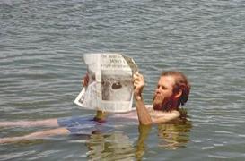
It is estimated that some 280 million tons of solid minerals are dissolved in Mono Lake (www.monolake.org). It is a triple-water lake; high levels of saline, alkaline and sulfurous materials are dissolved in it, as well as borate, fluoride, arsenic, plutonium and uranium in surprising amounts (Hart, 14).. The high amounts of carbonates, which increase alkalinity, make the pH of Mono Lake 10, about the pH of a household glass cleaner. The water is bitter and heavy (www.monolake.org). Some scientists believe that the water in Mono Lake is very similar to the water that would have been in a Pre-Cambrian lake millions of years ago, although there is no way of testing this (Hart, 15).
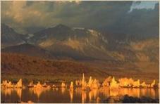
11. David Gaines, from Mono Lake Committee floating in Mono LakeAn interesting side effect of the chemicals in the water are the tufa towers. These towers are calcium carbonates, the same material as limestone. These towers form underground when the calcium from underground springs interacts with the carbonates in the lake water. The calcium carbonates settle into solids around the mouth of the spring and eventually grown into the tufa towers. The towers cannot grow above water, but within the lake they can grow up to 30 feet. When the lake level dropped because of the diversions, the tufa towers near the shore were exposed. The tufa towers can also form in other areas of the lake, as long as they have a nucleus to form around. They have been known to form around beer cans, pumice boulders, and dead plants and animals. They can also form through biogenesis. This occurs when an adult alkali fly emerges from the pupae case. The fly leaves a minute amount of calcium carbonate behind as the waste product from the pupal stage. This calcium carbonate can help form more tufa structures (www.monolake.org).
12. Tufa TowersBiology
While Mono Lake is too saline and alkaline to support fish life it does have two highly specialized inhabitants, the alkali fly and the brine shrimp. Both of these species are unique to Mono Lake. The large numbers of flies and shrimp, and the fact that there are no fish competitors, draw migratory birds from around the world to the area as they fly from North America to South America.
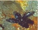
The alkali fly has three life stages, the larval, pupal, and adult stages. The hairs on the adult fly and the thickness of the Mono Lake water allow the adult female flies to walk underwater in a small air bubble to lay their eggs. When they reach the pupal stage, the worm-like larvae attach themselves to the bottom of rocks and make a small pupae case. When the adult fly is ready to emerge it separates its head from the pupal case and then reattaches the head after it is out of the case. The fly then comes to land where it eats algae and decomposing materials on the shoreline (www.monolake.org).
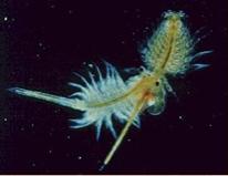
13. Alkali FlyThe brine shrimp also eat the algae of Mono Lake. In the spring, shrimp hatch from cysts at the bottom of the lake, mature and hatch a live brood in the early summer. This generation lays cysts at the end of the summer which live dormant through the winter and hatch in the spring. It has been estimated that during the summer there are seven trillion brine shrimp living in the lake (Hart, 15).
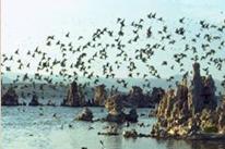
14. Brine ShrimpThe brine shrimp and alkali fly provide enough food to feed nearly 100 species of migratory birds (www.monolake.org). Mono Lake supports from 44,000 to 65,000 California gulls, second only to the Great Salt Lake, as well as 30,000-70,000 Wilson's Phalaropes, and 750,000 Eared Grebes as they migrate to South America (Hart, 18).
15. Wilson�fs PhalaropesPolitical History
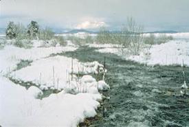
16. Lee Vining Creek after 1994Despite Mono Lake's rich history and importance to migratory birds, from 1941 to 1994 the Los Angeles Department of Water and Power diverted all the water from the three largest streams feeding Mono Lake. During this time, the water level dropped from 6,417 feet above sea level to 6,372 feet above water level at its lowest level. The lowering water level caused the lake's chemical levels to rise drastically. The salinity increased from 51.3 grams per liter to 99.4 grams per liter. This greatly affected the photosynthetic rates of the algae dropped and the reproductive ability of the brine shrimp dropped. The streams dried up, destroying fisheries and habitats near the streams. The water receded, leaving the chemical rich shore bed to dry in the sun. The chemicals in the former lake bottom were picked up in dust storms by the wind, exposing people to harmful chemicals. The lowering lake levels created land bridges to the islands in the lake where the gulls nested and left them vulnerable to coyotes. In 1978, the Mono Lake Committee was formed to help protect the lake. For decades legal battles over the water rights were waged between the DWP, the Mono Lake Committee, the Audubon Society, and the California Trout Committee fought for the water that flows into Mono Lake. In 1994, the State Water Resources Control Board decided that Mono Lake must be kept at 6,392 feet above sea level. It was estimated that this would take 20 years to accomplish with a few diversions to Los Angeles, but growth has been slow because of dry winters. Eventually the water will reach the decreed levels and the DWP will be allowed to divert just enough water that the lake level is maintained (www.monolake.org).
17. Chemical dust on dried shore bedWorks Cited:
1. Hart, John. Storm Over Mono: The Mono Lake Battle and the California Water
Future. Berkeley: University of California Press, 1996.2. Hill, Mary. Geology of the Sierra Nevada. Berkeley: University of California Press: 1975.
3. Mono Lake Committee Web Page. Jun 9, 2004. Mono Lake Committee. Accessed June 10, 2004. {www.monolake.org}
4. Tierney, Timothy. Geology of the Mono Basin. Lee Vining: Mono Lake Committee:1997.
Images:
1. Mono Lake Committee Web Page. Jun 9, 2004. Mono Lake Committee. Accessed June 10, 2004. {www.monolake.org}
2. http://atlas.geo.cornell.edu/education/instructor/tectonics/subduction.html
3. rst.gsfc.nasa.gov/ Sect6/Basin&Range. Carolina Map Distributors.
4. geology.csupomona.edu/ docs/calderaxsecl.jpg
5. Mono Lake Committee Web Page. Jun 9, 2004. Mono Lake Committee. Accessed June 10, 2004. {www.monolake.org}
6. www.indiana.edu/~sierra
7. www.indiana.edu/~sierra
8. Mono Lake Committee Web Page. Jun 9, 2004. Mono Lake Committee. Accessed June 10, 2004. {www.monolake.org}
9. Mono Lake Committee Web Page. Jun 9, 2004. Mono Lake Committee. Accessed June 10, 2004. {www.monolake.org}
10. www.alaska.net/~design/ scenes/kenai/glaciers.jpg
11. Mono Lake Committee Web Page. Jun 9, 2004. Mono Lake Committee. Accessed June 10, 2004. {www.monolake.org}
12. Mono Lake Committee Web Page. Jun 9, 2004. Mono Lake Committee. Accessed June 10, 2004. {www.monolake.org}
13. Mono Lake Committee Web Page. Jun 9, 2004. Mono Lake Committee. Accessed June 10, 2004. {www.monolake.org}
14. Mono Lake Committee Web Page. Jun 9, 2004. Mono Lake Committee. Accessed June 10, 2004. {www.monolake.org}
15. Mono Lake Committee Web Page. Jun 9, 2004. Mono Lake Committee. Accessed June 10, 2004. {www.monolake.org}
16. Mono Lake Committee Web Page. Jun 9, 2004. Mono Lake Committee. Accessed June 10, 2004. {www.monolake.org}
17. Mono Lake Committee Web Page. Jun 9, 2004. Mono Lake Committee. Accessed June 10, 2004. {www.monolake.org}