Geology and Natural Heritage of the Long Valley Caldera
Glacial Geology of the Sierra Nevada Landscape
Robin Hong
California’s Sierra Nevada mountain range has been shaped by various elements since its inception hundreds of millions of years ago. Back then, tectonic processes formed the large granitic Sierra structure, or batholith. In a nutshell, heat generated by decaying radioactive material in the Earth’s core rose to the surface through convection currents, transported upwards through molten rock. The heat caused the crust to melt and plates to jolt at the surface. Cooling rock produced the batholith, and so was the birth of the Sierra Nevada chain, which would be altered through the ages. Today, the Sierra is characterized by dramatic features such as sharp mountain peaks and wide-ranging valleys, as a result of glacial geology. Glacial geology simply refers to the effects of glaciers on a landscape.
During the last Ice Age (also called the Pleistocene Epoch) which ended approximately 10,000 years ago, huge glaciers flowed over entire continents or large areas of them. Covered areas included the eastern U.S., Canada, and the western U.S. though not the Sierra Nevada range. The Sierra, however, was a prime area for forming its own glaciers independent from the ice sheets because of high elevation and close proximity to the ocean. High peaks can contain more snow and hinder snowmelt, the latter of which is more important for glaciers than actual amount of snowfall. Coastal location allows for more evaporation which in turn paves the way for more-than-average accumulation of snow in the mountains. As a result, this area of California produced large mountain and valley glaciers (those which form in an eroded river valley), measuring up to 60 miles in length (Guyton, 1998).
It was discovered in 1931 that at least four major glacial advances occurred in the Sierra Nevada area during the Quaternary Period, the era which encompassed the Pleistocene and Holocene Epochs. (No glaciations had occurred in any Ice Ages prior to the Quaternary Period.) The episodes were named after the locales in which their deposits were discovered: Tioga (about 20,000 years ago), Tahoe (about 100,000 years ago), Sherwin (about 1,000,000 years ago) and McGee (about 1,500,000 years ago) Glaciations. In the 1970s it was discovered that a more recent glaciation, the Recess Peak, had occurred, but contained much smaller glaciers than previous episodes.
On a basic level, a glacier can be defined as a large mass of snow which turns to ice, can flow downhill on its own weight when on a slope, and remains in existence for a considerable amount of time. As stated previously, glacier formation is not dependent on total amount of snowfall, but rather quantity of accumulated snow exceeding snowmelt (thus, glaciers can thrive in mountain areas). As snowflakes fall, they adhere and bond at their surfaces. With time, the accumulated snow becomes denser and stronger and turns into ice. Ice crystals are weak, and therefore it is not difficult for a large glacier to slip and flow on a plane. When flowing downhill, a glacier can slide over an obstacle in its path, unlike water which can only remain behind an obstacle at first. Also, glaciers can float since liquid water is denser than ice (Sugden and John, 1976).
The glacial landforms in the Sierra Nevada region were created by the two basic processes of erosion and deposition. However, these mountain glacier-created landforms differ from those shaped by continental ice sheets. A general overview of glacial processes as well as a closer examination of the Sierra glaciers follows.
Erosion
“A great glacier once formed far back in the mountains and passed down the valley, polishing and grooving the rocks for more than a thousand feet up on each side, rounding the granite hills into domes…”
-How William H. Brewer of the newly founded California Geological Survey described the effects of the Tuolumne Glacier in 1863.
The sheer power and strength of a glacier allows it to corrode rock that it comes in contact with. Ice and rock work as natural chisels which leave behind carved landscapes that are sharper, steeper and more dramatic than before. Many variables affect the erosion process, including quantity and characteristics of debris in a glacier, temperature and meltwater at the base of a glacier, and pressure of ice on bedrock (which is affected by thickness of ice and structure of bedrock). Bedrock touched by a glacier will often have a smooth and polished surface; or, it will be marked by linear scratches. Such observations are evidence of erosional plucking and abrasion.
Plucking refers to when a glacier moves across a slab of rock, ice freezes to portions of the bedrock, and pieces are lifted by the glacier as the glacier moves downwards. When a glacier lays on bedrock, pressure causes melting near any jutting rocks. The meltwater flows into the rock’s pores and freezes again, thereafter splintering the rock. The rocks are then carried off with the glacier (Sharp, 1988). Plucking is more effective with jointed rocks (rocks that have fractures but little displacement) and “roche moutonnee” (French term for an asymmetrical chunk of rock which is smooth by abrasion on one slope and rough and steep on the other due to plucking, and looks like a sheep).
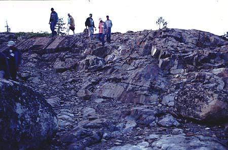
Figure 1. Area in Sierra Nevada that was plucked by a glacier.
http://www.ship.edu/~cjwolt/geology/slides/gl-sum.htmAbrasion occurs when the glacier with its embedded rock fragments smooths or gouges bedrock below it and the fragments in it as well. Small-grained fragments in the glacier polish the rock surface and produce “rock flour,” and larger fragments cause striations in the bedrock. Striations can also provide clues about the direction and pressure of the glacier.
Abrasion is especially affected by the aforementioned factors, according to David Sugden. Debris in the glacier is a requirement for abrasion to occur, as a basal layer of particles will cause more grinding than pure ice. A faster-moving glacier will cause more abrasion due to its velocity. Rock fragments must keep moving downwards to the base of the glacier to be effective abrasives, as moving ice will cause pieces in it to wear down eventually; melting at the glacial base will allow this shifting to occur. Thicker ice will allow more pressure to be exerted onto underlying bedrock. If there is water at the bottom of a glacier, abrasion will be less effective because buoyancy will reduce downward pressure. The hardness of the bedrock relative to the rock fragments affects the style of abrasion. Angular particles will cause more scratching than rounded ones; larger fragments will cause more downward pressure. Rock flour between the base of the glacier and bedrock hinders abrasion. (Sugden and John, 1976)
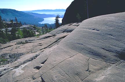
Figure 2. Glacially striated granite at Donner Pass, Tahoe National Forest.
www.geoscapesphotography.com
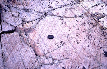
Figure 3. More glacial striated rocks in the Sierra Nevada.
http://www.ship.edu/~cjwolt/geology/slides/gl-sum.htmErosion by valley glaciers is capable of producing very distinct landforms. Valleys were typically V-shaped before the Ice Age, as rivers widened as they flowed downwards. As a glacier moved down a river valley, it smoothed out and deepened the valley into a rounded U-shape. Perhaps the best example of a rounded valley is the Yosemite Valley, which is a half mile deep and is surrounded by mountain peaks. Other features eroded by valley glaciers are cirques (depressions eroded away at the origin of a glacier when moving ice removed jointed rocks, and sometimes contain lakes after the glacier melted), arętes (edges where cirques meet), horns (sharp peaks formed by cirques), and hanging valleys (smaller troughs which “hang” above the main valley, were formed by tributary ice streams and often are a source of waterfalls).
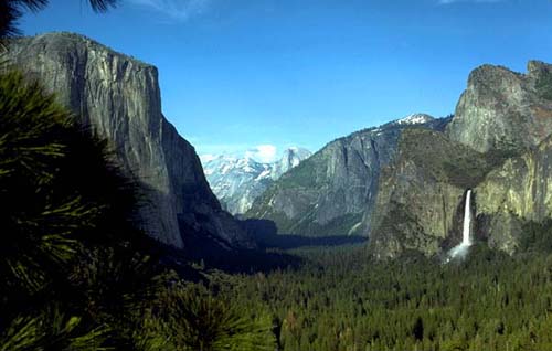
Figure 4. Bridalveil Fall in Yosemite Park, seen here on the right, falls from a hanging valley. http://www.neuswaterfalls.com/bridalveil1.htmThe area around Mt. Lyell, the highest peak in Yosemite Park, was referred to as “biscuit-board topography” because of its many deep cirques. Glaciers formed around the then-rounded mountains, and kept eroding land until the rock between cirques became sharp horns. Around the turn of the century, Willard D. Johnson of the U.S. Geological Survey climbed into a crevasse of the Lyell Glacier to learn about formation of cirques and processes of erosion. As he was between rock and ice near the bottom, he discovered that when meltwater fills a crevasse, it freezes and the resulting ice plucks the adjacent rock. As the rock is eroded, the glacier moves towards it and works the same process. By this means, the glacier continues to move frontward and erode rock, expanding the cirque it has created. This process of creating and expanding a cirque is called basal sapping.
Deposition
Tuolumne Meadows in present-day Yosemite Park, where the Tuolumne Glacier once passed over, is characterized by layers of till. In 1865 Josiah Whitney of the Caifornia Geological Survey stated that “the whole region about the head of the Upper Tuolumne is one of the finest in the State for studying the traces of the ancient glacier system of the Sierra Nevada…All of the phenomena of the moraines – lateral, medial, and terminal – are displayed here on the grandest scale.”
Whether glaciers move across huge areas of land or within mountainous topography, they can lift and carry sizeable amounts of debris from the ground, like a bulldozer. The glacier carries the material usually far from the source; upon the glacier’s melting, the material is deposited into the ground and can accumulate very thickly, covering the ground. Remnants of transport and deposition include unsorted rocks and finer grains, called till, and large boulders referred to as glacial erratics. Such evidence as till and erratics provide clues about stages of glacial progressions. To identify deposits as from different eras, one may observe weathering of rocks, soil development, volcanic ash; use carbon and isotope dating methods measure speed of sound waves through a boulder, or measure sound traveling through a boulder (Guyton, 1998)
A moraine is a ridge of rocky deposited till, and can be classified as end or lateral/medial. End moraines, rather obviously, form at the end of a glacier. Lateral moraines are sediments accumulated by a glacier from the sides of a river valley. Medial moraines form when two glaciers meet to form a single stream. David Sugden describes moraines as being poorly sorted, having clasts of different sizes and composition within a fine matrix, being mostly sub-angular in clast shape because of breakage and abrasion, and as being compact due to pressure from glacial deposition (Sugden and John, 1976).
Glacial deposition can occur between a valley glacier and its trough, on a glacier surface, around the whole glacier, or between a glacier and its underlying water. Sedimentary material can either be deposited by the glacier or its meltwater. Sometimes when a glacier “bulldozes” material which has already been deposited once, mounds up to 100 meters high can be formed (Sharp, 1988).
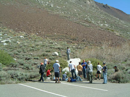
Figure 5. IU class at McGee Creek moraine, site of the oldest glacial deposit in California. http://www.indiana.edu/~sierra/news/day11.html
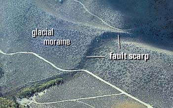
Figure 6. Aerial view of McGee Creek moraine, with visible offset by Hilton Creek Fault. http://lvo.wr.usgs.gov/gallery/30714277-068_caption.html
The Sierra Nevada mountain range and its neighboring areas are a prime example of spectacular natural beauty. The steep mountain peaks, deep valleys and unusual formations are the result of carving by glaciers during the Ice Age. According to Bill Guyton, the world is currently in a state of interglaciation, and another major glaciation is very likely to occur in the future. Another Ice Age as momentous as the most recent Tioga would cause an extreme shift of climate, and devastation to a rapidly growing society.
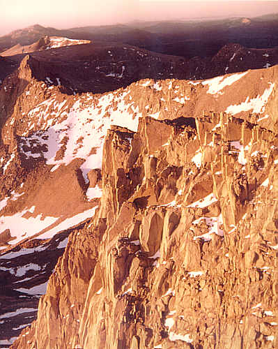
Figure 7. Mt. Whitney's craggy peaks at sunrise.
http://www.sierranevadaphotos.com/gallery/image.asp?mt_whitney_sunriseBibliography
Guyton, Bill (1998), Glaciers of California, Berkeley, California: University of
California Press.Hill, Mary (1975), Geology of the Sierra Nevada, University of California Press. Sharp, Robert (1988), Living Ice: Understanding Glaciers and Glaciation, Cambridge: Cambridge University Press.
Sugden, David E., and John, Brian S. (1976), Glaciers and Landscape: A Geomorphological Approach, New York: Routledge, Chapman and Hall, Inc.
Taber, C.A.M. (1907), The Cause of Geologic Periods, Boston: Geo. H. Ellis Co. Printers. Wright, G. Frederick (1889), The Ice Age in North America and Its Bearings Upon the Antiquity of Man, New York: D. Appleton and Co.