Geology and Natural Heritage of the Long Valley Caldera
Geology of Death Valley
Adam Ganson
The geological formation of the western third of the contiguous United States occurred as a result of plate tectonic movements in the Proterozoic period. The Farralon plate shifted and subducted beneath the North American plate. This movement caused a mountain building process and much volcanic activity in the millions of years to follow. As a result of this mountain building, massive mountains pervade the landscape and between these ranges are basins that internally drain all of the water that precipitates in the mountains. In California this feature is prevalent throughout the landscape. The basin and range landforms are responsible for much of the climate of Eastern California.Deep in one of these basins is the infamous Death Valley. One would assume that by the name of this place it is a relentless desert without life. It is an unforgiving desert, however it is teeming with life, and the geological processes that create the landscape are easily recognizable because of the exposure of the rocks, however very complex in identifying how the formations came to be because of the long and complicated history that formed the desert. Lake sedimentation, plate tectonics, volcanic eruptions, water and wind all played and some still play an integral part in the way that Death Valley was shaped. This diverse history is somewhat difficult to reconstruct, however the diversity makes the place a most interesting place. The mountain ranges that make up Death Valley are the Black Mountains to the east, the Panamint Range to the west, and the Grapevine Mountains lie directly to the north. All of these ranges control the present day geological processes that govern this area.
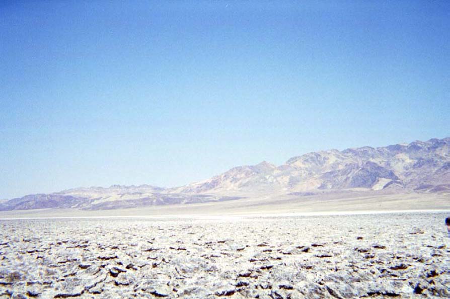
As we drove up the Black Moutains on a switchback road getting closer to the magnificent Dante’s View, we beheld geological processes at work. The length of the valley stretched for 156 miles north to south. The highest peak to the west of the valley is Telescope Peak at 11,049 feet and it is nearly a 15-mile drop to the bottom of the valley. Dante’s View stands at 5,475 feet above the floor of the valley. Both of these peaks stretch down to the lowest point in the contiguous United States 282 feet below sea level at Badwater. The valley floor is covered with white salt that appear as if they are the remnants of sinuous streams or lakes that used to exist in the valley floor. Upon this magnificent perch it is easy to see the fault lines that govern the formation of the heights of these mountains. As a result of plate tectonics and the tension that it created these faults were created as spreading in the region was created. There was then a massive moutain range and a deep hole that was beginning to form deep in the Earth. The mountains started to erode into the hole that the fault lines were creating filling it with the sediments from the mountains. When there was a lake that existed in this basin salts could not precipitate, however when the rain shadow was created by the crustal uplift of the Sierra Nevada mountains the area became a desert and the salt on the valley floor were able to form. (USGS web site) Smaller fault lines that occur everywhere throughout Death Valley compliment the major fault lines. These fault lines are apparent by the shifting of materials within the rocks that make up the mountains. They are created by the tensional activity of the basin and range landscape. Allen van Volkenburg described the geology of Death Valley to a piece of chewed gum. When it was created all of the rocks were very uniform however throughout time, as a result of these fault lines and, erosional factors such a wind and water the piece is very difficult to put together in its original formation. It is thought that the mountain ranges were severely altered when they shifted and the Black Mountains fell from on top of the Amargosa Mountains. This belief dwarfs the mountains of today suggesting that the mountains of the past towered over the valley. The faulting that occurred continues today and the valley continues to drop.
The formation of Death Valley today is only a small amount of the entire history of the landscape. A chain of Volcanoes that erupted caused the earliest evidence of rocks in the region. During the Proterozoic period a sea covered the area. This is also when the continental drift was occurring. During the Cambian era a thick wedge of sediment made its way into the area where Death Valley is today. There were events that interrupted the processes that the area was going through such as a great sheet of pure sand and sediment deposition. During the Jurassic period there was a period of crustal uplift in the area, which created the Sierra Nevada Mountains and also created a chain of volcanoes in the area. (USGS web site and Sharp and Glazner) Evidence of this volcanic area is a cinder cone that exists in the Death Valley. An interesting aspect of the cinder cone is that there is a fault line located in the middle of the geologic structure. As a result the cinder cone is splitting apart and the two sides are being moved lateral to each other. It was during the Tertiary period that Death Valley started to take on the form of how it exists today. The fault lines started to produce drastic difference in elevation and Alluvial fans started to spread out into the valley.
These Alluvial fans are an important formative element to the desert in the present day. As previously stated the rain shadow of the Sierra Nevada captures the amount of rainfall that is allowed into the Death Valley region. The average amount of rainfall that precipitates in the Death Valley region is .1375 inches per year. When rain falls in the region there is very little flora and fauna to capture the water and the erosion that occurs as a result is drastic. At the base of the Panamint Range and the Black Mountains there are Alluvial fans that stretch for miles that were created by the material coming out from the mountains. The coarser grains get caught in the mountains as flash floods rush through canyons and the finer grains are pushed into the valley. When the water source hits an flatter elevation the water loses its single path direction and spreads out creating a fan-like formation. This erosional process is important in the incessant formation of the desert valley.
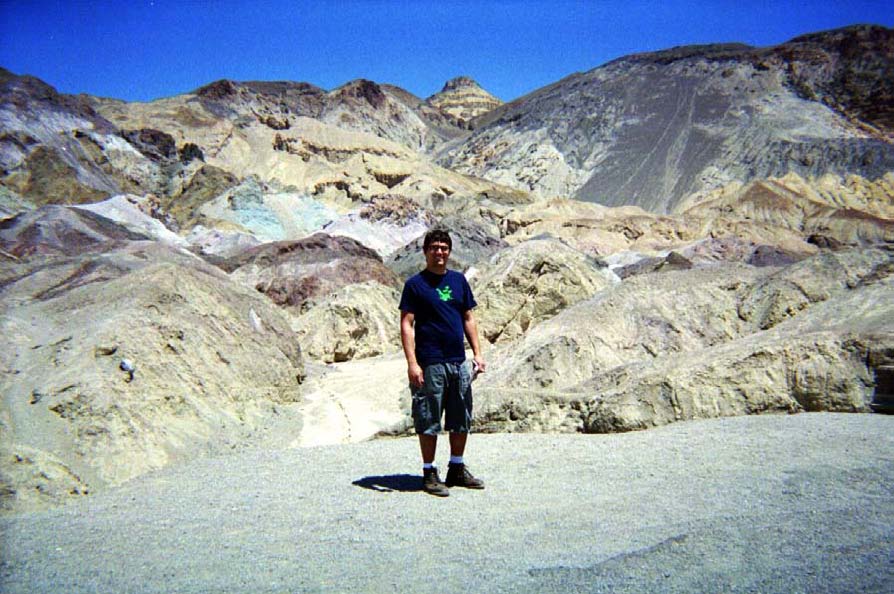
The badlands of Death Valley are another water-oriented formation. The most famous of these formations located at Zabriskie Point is very aesthetically pleasing to the eye and its formation is a wonder to the mind. At first glance the badlands are completely barren, and they are made of a uniform soil that has many divots and pathways along the hills into the valley. These intricately and naturally decorated badlands were once a uniform and level area created by Death Valley’s diverse past. There was once a lake that resided where the badlands now are and this loosely consolidated material was once the bed of the lake. (US GS website) When the rain shadow was cast upon the valley and the lake dried up, this loosely consolidated material began to be influenced by the flash floods that frequented the area. The water cut pathways into the lake sediment and continued to follow those pathways. This is why the badlands have a multitude of creases that follow gravity into the valley.
Upon closer examination of the Valley floor, we discovered that there were saltpans that extended along much of the valley floor. Theses saltpans were shaped hexagonally and the perimeter was raised higher than the rest of the salt deposit. These are formed after a flash flood. The salt is carried down from the mountains and because of the incessant dry heat in the desert the water is quickly evaporated. As a result the salt that is deposited with the water is left behind. The salt expands in different directions as the water evaporates and these mysterious shapes are formed. There is a layer of mud that is kept moist because of the salt insulator on top and when the mud dries and cracks between these shapes the salt fills in the spaces and the sides are raised higher than the rest of the saltpan. Every time that a flash flood occurs, the salt is dissolved in the water and the polygons are destroyed, the process however is started all over. It takes close to 35 years to form one inch of salt on the valley floor.
During World War I when the Germans cut off the supply line from Chile to the United States of Nitrates used in the production of explosives, the federal government turned to the resources of Death Valley. There were holes that we dug in the extreme heat of the area and some nitrates were found, but not a significant and concentrated enough amount for a continued effort of mining in the area. (Miller and Wright) In addition to the nitrates that were found in the desert, there was also a concentration of borate mining plants. These mines were allowed under an 1873 act that said that anyone could claim a piece of land for development without tax paid to the government, so long as they maintained a working operation on the land that they had claimed. When Death Valley became a national monument in 1933 the mines that were already there could stay and the land they were mining was not protected under the newly acquired status. Today the Borate mines are not used for production however when Death Valley became a National Park in 1994 they mines became protected as well as the land that they were standing on.
An area that does not receive the amount of flash flood residue as the saltpans is Devil’s Golf Course. The same process is responsible for the formation of the Devil’s Golf Course, however since water rarely makes its way to the higher elevation where it is located the formations harden with mud and salt and create permanent polygonal shapes of salt deposits.
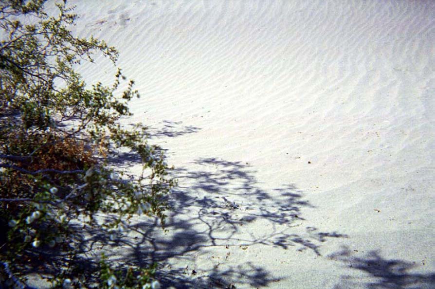
(Death Valley Website)Sand dunes are very popular in Death Valley for the sheer fact that people think of sand when they go to a desert. The sand dunes in Death Valley give visitors all they could want and more. There are two types of sand dunes, crescent sand dunes and star sand dunes. Both are created by wind erosion. Death Valley is a great place for sand dunes to be created. With a range on both sides and one to the north, the wind carries fine material to the north border of the valley. Here when the sand can no longer be carried, the wind deposits the sand in front of the barrier. The wind carries the sand and the will form a ridge on top of the sand dune. This is the crescent sand dune and is usually how people picture how a sand dune should look. There are also star sand dunes. This is a dune with more than 3 arms at the crest of the dune. This is caused by the wind moving material in a different direction than the prevailing winds are moving material. Many microcosms of dunes are created on the sand dune itself creating a rippling effect.
Death Valley’s diverse history has provided geologists with countless hours of trying to reconstruct the history of the region. They have found that many forces came together to form the beautiful landscape. All of these features make this place a favorite spot for people from all over the world. As a result of its ever-changing status it is always a joy and a wonder to lay eyes on the beauties of Death Valley.
References
- Miller, Martin and Lauren Wright Geology of Death Valley National Park Kendall Hunt Publishing 2002
- Sharp Robert and Allen Glazner Geology Underfoot in Death Valley and Owens Valley Mountain Press
- Publishing 1997 http://www.nps.gov/deva/ Official Death Valley
- Website 5/22/03 http://www2.nature.nps.gov/grd/usgsnps/deva.html USGS Death Valley website 6/29/00 Moreno