Geology and Natural Heritage of the Long Valley Caldera
Volcanic Hazards and Activity in the
Sierra Nevadas
Chris Bottorff
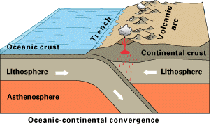
Long Valley may be the ideal setting of the Wild West, outfitting many with horse back riding, fishing, skiing, rock climbing, and hot springs; but few who live and visit there realize the volcanic activity that has shaped it and is continuing to work deep below the surface. The layout of the Sierran volcanic arc reveals a very complex pattern of plate tectonics. The Farillon Plate, which is no longer visible, was pushed down under the North American Plate at a convergent boundary during the Mesozoic era like the one shown here.
(Picture adapted from USGS website)The subduction of the Farillon plate caused the rock to melt and become less dense than the surrounding rock. It was then forced up through cracks in the lithosphere forming intrusions and magma chambers in the continental crust. (Sonoma 2002) This uplift led to the formation of the beautiful mountains that allow for the ski resorts and geological wonders of the Sierras today.
Volcanic HistoryAbout 760,000 years ago, the Bishop Tuff eruption ejected pyroclastic materials that went into the atmosphere and eventually settled all the way into western parts of Nebraska. This was followed by massive amounts of magma flow that covered a large part of the ash fall around the Long Valley Caldera creating the Bishop Tuff. After the series of eruptions the magma chamber was depleted leaving an empty void in the earths crust. The land above this chamber couldn’t support itself and collapsed about a mile down forming the ten by twenty miles Long Valley Caldera. The magma that was left in the chamber is continuing to show its presence through fumaroles (steam vents) and the popular hot springs. About fifty thousand years ago a series of eruptions ended creating the magnificent Mammoth Mountain. (Sonoma 2002)
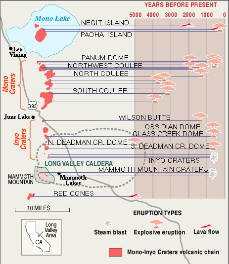
A little more recently, over the past 5,000 to 600 years magma began rising to the surface through dykes (vertical intrusions) along a fault line creating a series of volcanic domes and craters.
Illustration by R. Bailey and D. Hill (USGS Publications)This is an illustration of the recent volcanic activity that has formed into the Mono-Inyo Craters, creating ash falls and flows, fissures (cracks in the earth) and high valued ore. The picture shows highway 395 traveling straight through as it has become a major tourist road connecting the only airport in Mammoth Lakes area to Mono Lakes and the Yosemite Valley.
Drawn to the West
The volcanic activity has created many domes, mountains, and hills with much sought after valuable metals and glasses.
Natives
Many Native Americans like the Piute have occupied the land for many centuries. They found the land useful because of a diversity of life and vast obsidian deposits that were useful for tool making. The obsidian deposits were formed when the magma was forced through the dykes in a highly viscous form creating black glassy rhiolite (obsidian) and pumice solidifying as a concurrent ropy texture. The magmas would also cool at separate times overlapping itself and cracking creating a ‘bread crust’ texture.
Americans
Before the Gold Rush of 1849 few settlers had much interest in California. They wanted to get away from the tensions of the states and maybe find work in San Francisco. San Francisco was formed for Pacific trade to China and other countries and not until a few mill workers discovered some tiny gold nuggets, did Americans see the wealth in California. Soon the news was posted in “the Californian,” a San Francisco paper, and more than half a million people began to migrate into the California hillsides. In 1850 California became a state. (ceres.ca.gov)
The Gold deposits of the Sierra Nevada batholith were formed when the ore was heated into liquid form and seeped up into the cracks and pores in the bedrock. This hydrothermal fluid ran about 50-300 Celsius and had strong concentrations of chlorine, fluorine, and carbon dioxide which held large amounts of gold, silver and some copper and lead.Recent Activity
Earthquake Swarms
In 1978 the people living in the Long Valley area began to get a taste of what was to come in the following years when a 5.4 magnitude earthquake shook the ground. This was the first of what ended a long period of little activity. In 1980 they were struck by a swarm of earthquakes including four magnitude six shocks that appeared around the fault line. After this the USGS began heavily monitoring the Long Valley Caldera. They began to notice that the middle of the caldera was rising due to the increase of magma beneath the surface. From 1979 to 2000 the USGS watched it rise 2.5 feet in an area over 100 square miles. The USGS is now monitoring very closely with seismometers and working with the California Office of Emergency Response and civil authorities to be prepared for a possible eruption and have time to warn the public. (USGS 2000)
Tree Kill
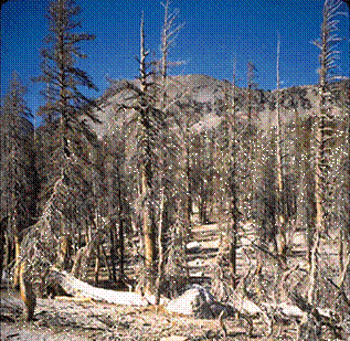
About the same time that the earthquake swarms began, carbon monoxide has been showing it’s presence around Mammoth Mountain. A Penn State researcher noticed that the annual monitoring of the gasses was flawed. He showed that the carbon monoxide measurements changed throughout the day and that the yearly measurements were not significant. (ScienceDaily 1998) The variance of the gasses he measured range from 20% of gas content in the soil to 90%. (USGS Fact Sheet-172-96) The lethal dose is 30% and as one unfortunate skier found out, the gas likes to build up under the snow. This makes the area very dangerous especially in the winter time. The tree kill areas have been closed for camping and totally off limits in the winter.
(Figure reproduced from U.S. Geological Survey Fact Sheet-172-96)The trees in the area are being killed off as the Co2 suffocates them by cutting off the oxygen and nutrients in the soil. It’s possible that the gas is formed from magma that rose through the fault creating cracks that allow the gasses to rise. (USGS Fact Sheet-172-96)
Volcanic Hazards
The possibility of another eruption has increased public awareness and is being heavily researched. Another eruption is anticipated to be less violent than past activity but it is hard to tell with the geologic equipment and technology of today. Based on the previous knowledge of the volcanic activity and the recent unrest, it is likely that the volcanoes are far from becoming dormant and the Mono-Inyo chain is most likely to erupt. The USGS can only predict the eruption days before it happens leaving little time to warn the public.
USGS Response Plan
In 1982 the USGS began installing seismometers to measure earthquake activity and instruments to measure ground swelling after the unrest began. They have also worked with the California Office of Emergency Services to prepare a document on a response plan to a possible eruption. This response plan is to organize and create procedures to respond to different levels of unrest and a brief summary to notify the public of activity taking place.
Planned USGS Response To Unrest In The Long Valley Area Geologic Behavior Condition USGS Response Typical Behavior
(No Immediate Risk)Routine Monitoring Intense Unrest
(Watch)Intensified Monitoring Eruption Likely
Within Hours or Days
(Warning)Geologic Hazard Warning Eruption Underway
(Alert)Sustained Monitoring and Communication (Figure reproduced from U.S. Geological Survey Fact Sheet 108-96)
Green is mainly moderate unrest occurring daily to monthly, yellow is intense unrest usually occurring years to decades and orange levels are set for an eruption that will occur in a matter of days to weeks. The red alert is set into four levels from minor eruption which usually are spaced by centuries and the massive eruptions are spaced by millennia. (USGS Bulletin 2185)
Volcanic Hazard Zones
Using previous knowledge of the last eruptions and their deposits along with eruptions around the world of similar volcanic chains, geologists can identify areas that might be subject to a future eruption. The next eruption is also very likely to be small or moderate, leaving most property and lives a very good chance of survival.
Tephra: The past eruptions ejected volcanic ash and pumice from a distance of 22 miles to 53 measured from 8 to 2 inches thick. The fragments accumulated around the vent averaged about 10 meters. This all varies with wind direction and scientist won’t be able to tell where the wind will blow but they know that historic volcanoes blow to the East more than 80 percent of the time. (USGS)
Pyroclastic Flows and Domes: Volcanic domes are formed when magma begins to build up beneath the earths crust usually formed around a vent or fault line. Up to a ten mile radius of the dome could be covered in an outburst of pyroclastic flow if the dome erupts. These flows consist of basal fragments and a dark cloud that follows it downwind destroying everything in its path.
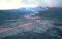
Lava Flows: Most lava flows are predictable and fairly safe as they often follow ravines and stream beds and are slow enough to walk away from, property on the other hand will be sacrificed.
Fluid basalt lava flow Mauna Loa, Hawai`I 1984 eruption
(Picture adapted from USGS Volcanic-Hazard Website)Clouds: The clouds erupted from the volcano sometimes reach the atmosphere and release foreign gasses and drift for miles. They damage airlines by corroding surfaces, causing engine failure and electronic problems which causes delayed or cancel flights. This could affect San Francisco’s and Las Vegas’s airports.
Outlook
May 1980 was the first public warning of an eminent eruption after the series of magnitude 6 earthquakes took place. Since then the resurgent dome has risen by a foot which makes it fairly obvious that the magma under the surface is expanding and increasing. The earthquakes that are accruing are being directly linked to magma movement beneath the surface. The influx of Co2 at horseshoe lake has some even believing that Mammoth Mountain may be on the verge of eruption. Chances are, it won’t, at least not for a very long time. The caldera is pretty active now, but other similar calderas have shown activity and since have not erupted. For now all we can do is just wait and see, keep a good monitor of the activity and evacuate if necessary.
So if you’re in the area, enjoy it and stand in awe as you look at the magnificent Mountains and bathe in the hot springs. Don’t worry too much about volcanic activity because according to the USGS, the chances of an eruption are less than one percent each year.Bibliography
Augusta Chronicle: Technology, “Potential Volcanic Eruption Could Bury California.” 2 Sept. 2001; www.augustachronicle.com/stories/090201/tec_124-6423.shtml
California’s Natural Resources: A Brief History of the Gold Rush. Extracted 5/29/03 http://ceres.ca.gov/ceres/calweb/geology/goldrush.html
Sonoma Libraries; Geography 390: Geography of California. www.sonoma.edu/users/f/fridel/california/390geology.htm Last Updated 3 Sept 2003.
USGS:
Long Term Outlook for Volcanic Activity in Long Valley Caldera and the Mono-Inyo Craters Volcanic Chain. 14 October 1999. http://lvo.wr.usgs.gov/Outlook.html
Volcanic-Hazard Zones for Small- to Moderate Sized Eruptions in the Long Valley—Mono Lake Area, California. 20 August 1999 http://lvo.wr.usgs.gov/zones/
Living With a Restless Caldera-Long Valley, California
USGS Fact Sheet 108-96, version 2.1. Revised May 2000
Response Plan for Volcano Hazards in the Long Valley Caldera and Mono Craters Region, California. Bulletin 2185. Created 2/13/02 http://geopubs.wr.usgs.gov/bulletin/b2185/b2185.pdf Last Modified 2-19-02Potential Hazards From Future Volcanic Eruptions in the Long Valley—Mono Lake Area, California. 30 November 1999. http://lvo.wr.usgs.gov/hazards/index.html
Invisible Co2 Gas Killing Trees at Mammoth Mountain, California. US Geological Fact Sheet -172-96 http://quake.wr.usgs.gov/prepare/factsheets/CO2/
ScienceDaily: Gas Release at Mammoth Mountain More Complex Than Expected. 1998-12-10 www.sciencedaily.com/releases/1998/12/981210082147.htm